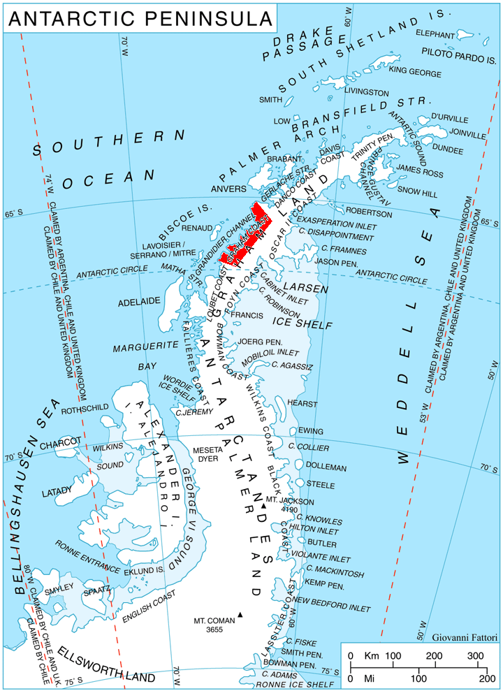
Plas Point on:
[Wikipedia]
[Google]
[Amazon]
 Plas Point ( bg, нос Плас, ‘Nos Plas’ \'nos 'plas\) is the point on the south side of the entrance to
Antarctic Digital Database (ADD).
Scale 1:250000 topographic map of Antarctica. Scientific Committee on Antarctic Research (SCAR). Since 1993, regularly upgraded and updated.
Plas Point.
Bulgarian Antarctic Gazetteer.
Antarctic Place-names Commission. (details in Bulgarian
basic data
in English)
Plas Point.
Copernix satellite image Bulgaria and the Antarctic Headlands of Graham Land Graham Coast {{GrahamCoast-geo-stub
Nevsha Cove
Nevsha Cove ( bg, залив Невша, ‘Zaliv Nevsha’ \'za-liv 'nev-sha\) is the 2.5 km wide cove indenting for 3 km Graham Coast on the Antarctic Peninsula north of Plas Point. It is part of the south arm of Beascochea Bay. The ...
, Graham Coast
Graham Coast is the portion of the west coast of Graham Land in Antarctic Peninsula, extending 172 km between Cape Bellue to the southwest and Cape Renard to the northeast.
The coast is named after Sir James Graham, First Lord of the Admir ...
on the Antarctic Peninsula
The Antarctic Peninsula, known as O'Higgins Land in Chile and Tierra de San Martín in Argentina, and originally as Graham Land in the United Kingdom and the Palmer Peninsula in the United States, is the northernmost part of mainland Antarctic ...
. Its shape was enhanced as a result of the adjacent Funk Glacier
Funk Glacier () is a glacier flowing into the head of Nevsha Cove in Beascochea Bay to the south of Frölich Peak, on the west coast of Graham Land, Antarctica. It was first charted by the French Antarctic Expedition, 1908–10, under Jean-Bapti ...
and Cadman Glacier
Cadman Glacier () is a glacier, wide at its mouth and about long, flowing northwestward into the head of the southern arm of Beascochea Bay south of Plas Point on the west side of the Antarctic Peninsula.
History
The glacier was discovered an ...
retreating during the last decade of 20th century and the first decade of 21st century.
The feature is named after Plas Peak in Pirin Mountain
The Pirin Mountains ( bg, Пирин ) are a mountain range in southwestern Bulgaria, with Vihren at an altitude of 2,914 m being the highest peak.
The range extends about 80 km from the north-west to the south-east and is about 40 ...
, Bulgaria.
Location
Plas Point is located at , which is 11.65 km southeast of Chiloé Point and 6.15 km south-southeast ofHolst Point Holst Point () is a point at the head of Beascochea Bay which divides it into two arms, on the west coast of Graham Land, Antarctica. It was first charted by the British Graham Land Expedition under John Rymill, 1934–37, and was named by the UK A ...
.
Maps
Antarctic Digital Database (ADD).
Scale 1:250000 topographic map of Antarctica. Scientific Committee on Antarctic Research (SCAR). Since 1993, regularly upgraded and updated.
References
Plas Point.
SCAR
A scar (or scar tissue) is an area of fibrous tissue that replaces normal skin after an injury. Scars result from the biological process of wound repair in the skin, as well as in other organs, and tissues of the body. Thus, scarring is a n ...
Composite Antarctic Gazetteer
The Composite Gazetteer of Antarctica (CGA) of the Scientific Committee on Antarctic Research (SCAR) is the authoritative international gazetteer containing all Antarctic toponyms published in national gazetteers, plus basic information about ...
.
Bulgarian Antarctic Gazetteer.
Antarctic Place-names Commission. (details in Bulgarian
basic data
in English)
External links
Plas Point.
Copernix satellite image Bulgaria and the Antarctic Headlands of Graham Land Graham Coast {{GrahamCoast-geo-stub