Pharr Mounds on:
[Wikipedia]
[Google]
[Amazon]
Pharr Mounds is a

Pharr Mounds on Flickr
Archaeology of prehistoric native America: an encyclopedia
{{Protected Areas of Mississippi Archaeological sites on the National Register of Historic Places in Mississippi Miller culture Mounds in Mississippi National Register of Historic Places in Itawamba County, Mississippi National Register of Historic Places in Prentiss County, Mississippi Protected areas of Itawamba County, Mississippi Protected areas of Mississippi Protected areas of Prentiss County, Mississippi
Middle Woodland period
In the classification of :category:Archaeological cultures of North America, archaeological cultures of North America, the Woodland period of North American pre-Columbian cultures spanned a period from roughly 1000 BC to European contact i ...
archaeological site
An archaeological site is a place (or group of physical sites) in which evidence of past activity is preserved (either prehistoric or recorded history, historic or contemporary), and which has been, or may be, investigated using the discipline ...
located near Tupelo
Tupelo commonly refers to:
* Tupelo (tree), a small genus of deciduous trees with alternate, simple leaves
* Tupelo, Mississippi, the county seat and the largest city of Lee County, Mississippi
Tupelo may also refer to:
Places
* Tupelo, Arka ...
in parts of Itawamba and Prentiss counties in northern Mississippi
Mississippi ( ) is a U.S. state, state in the Southeastern United States, Southeastern and Deep South regions of the United States. It borders Tennessee to the north, Alabama to the east, the Gulf of Mexico to the south, Louisiana to the s ...
. This complex was made of earthwork mounds.
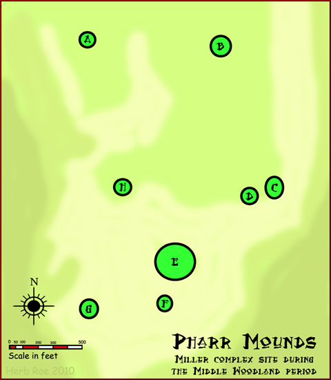
The complex of eight dome-shaped, tumulus burial mounds
A tumulus (: tumuli) is a mound of earth and stones raised over a grave or graves. Tumuli are also known as barrows, burial mounds, mounds, howes, or in Siberia and Central Asia as ''kurgans'', and may be found throughout much of the world. ...
was in use during the Miller 1 phase of the Miller culture. These were constructed as earthwork mounds between 1 and 200 CE. The complex is considered to be one of the largest and most important sites from this era. It was listed on the National Register of Historic Places in 1978 as part of the Natchez Trace Parkway
The Natchez Trace Parkway is a limited-access national parkway in the Southeastern United States that commemorates the historic Natchez Trace and preserves sections of that original trail. Its central feature is a two-lane road that extends 44 ...
at milepost 286.7.
Site description
The site is located at the headwaters of theTombigbee River
The Tombigbee River is a tributary of the Mobile River, approximately 200 mi (325 km) long, in the U.S. states of Mississippi and Alabama. Together with the Alabama, it merges to form the short Mobile River before the latter empties i ...
, a rugged, hilly area with many broad, swampy streams. It is named for "Pharr Flats", a wide, gently rolling terrace overlooking the confluence of Little Brown and Mackeys creeks. The site features eight dome-shaped mounds of differing sizes, several of which have been nearly flattened by plowing and cultivation during European-American farming. The mounds in the Pharr Mounds site are found over an area of 90 acres of land.

Archaeology
In 1966 Charles Bohannon, an archaeologist for theNational Park Service
The National Park Service (NPS) is an List of federal agencies in the United States, agency of the Federal government of the United States, United States federal government, within the US Department of the Interior. The service manages all List ...
, supervisedExcavation at the Pharr Mounds, US Department of Interior. July, 1972 an excavation of four of the mounds. The excavators found fire pits and low clay platforms at the base of the mounds. They also found human remains, some cremated, as well as various ceremonial artifacts.
Many of the artifacts were made from non-local materials, such as Great Lakes
The Great Lakes, also called the Great Lakes of North America, are a series of large interconnected freshwater lakes spanning the Canada–United States border. The five lakes are Lake Superior, Superior, Lake Michigan, Michigan, Lake Huron, H ...
copper and greenstone, galena
Galena, also called lead glance, is the natural mineral form of lead(II) sulfide (PbS). It is the most important ore of lead and an important source of silver.
Galena is one of the most abundant and widely distributed sulfide minerals. It crysta ...
, and mica
Micas ( ) are a group of silicate minerals whose outstanding physical characteristic is that individual mica crystals can easily be split into fragile elastic plates. This characteristic is described as ''perfect basal cleavage''. Mica is co ...
, demonstrating the reach of trading through the Hopewell exchange system. These artifacts, which include copper ear-spools and a greenstone platform pipe, show the connection of the local peoples with the larger Middle Woodland period world of the time, reaching to the Great Lakes.
See also
* Bynum Mound and Village Site * Grand Gulf Mound *Woodland period
In the classification of :category:Archaeological cultures of North America, archaeological cultures of North America, the Woodland period of North American pre-Columbian cultures spanned a period from roughly 1000 BC to European contact i ...
References
External links
Pharr Mounds on Flickr
Archaeology of prehistoric native America: an encyclopedia
{{Protected Areas of Mississippi Archaeological sites on the National Register of Historic Places in Mississippi Miller culture Mounds in Mississippi National Register of Historic Places in Itawamba County, Mississippi National Register of Historic Places in Prentiss County, Mississippi Protected areas of Itawamba County, Mississippi Protected areas of Mississippi Protected areas of Prentiss County, Mississippi