Mount Perchot on:
[Wikipedia]
[Google]
[Amazon]
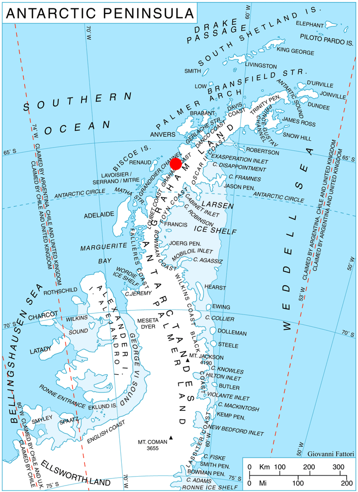
 Mount Perchot () is a
SCAR Composite Gazetteer of Antarctica
Mountains of Graham Land Graham Coast {{GrahamCoast-geo-stub
mountain
A mountain is an elevated portion of the Earth's crust, generally with steep sides that show significant exposed bedrock. Although definitions vary, a mountain may differ from a plateau in having a limited summit area, and is usually higher t ...
, 2,040 m, surmounted by Lisiya Ridge
Lisiya Ridge (, ‘Lisiyski Hrebet’ \li-'siy-ski 'hre-bet\) is the ice-covered ridge rising to over 2100 mMagnier Peaks
The Magnier Peaks () are two mountain peaks, the higher at , surmounting the peninsula between Leroux Bay and Bigo Bay on the west coast of Graham Land, Antarctica. These peaks were discovered and named by the Fourth French Antarctic Expedition, 19 ...
on Magnier Peninsula
Magnier Peninsula is the mostly ice-covered peninsula projecting 18 km in northwest direction from Graham Coast in Graham Land, Antarctica. It is 17 km wide between Leroux Bay to the northeast and Bigo Bay to the southwest. Magnier Peaks rise ...
, Graham Coast
Graham Coast is the portion of the west coast of Graham Land in Antarctic Peninsula
The Antarctic Peninsula, known as O'Higgins Land in Chile and Tierra de San Martin in Argentina, and originally as Graham Land in the United Kingdom and the Palm ...
in Graham Land
Graham Land is the portion of the Antarctic Peninsula that lies north of a line joining Cape Jeremy and Cape Agassiz. This description of Graham Land is consistent with the 1964 agreement between the British Antarctic Place-names Committee ...
, Antarctica
Antarctica () is Earth's southernmost and least-populated continent. Situated almost entirely south of the Antarctic Circle and surrounded by the Southern Ocean (also known as the Antarctic Ocean), it contains the geographic South Pole. ...
. Discovered by the French Antarctic Expedition
The French Antarctic Expedition is any of several French expeditions in Antarctica.
1837–1840
In 1837, during an 1837–1840 expedition across the deep southern hemisphere, Captain Jules Dumont d'Urville sailed his ship ''Astrolabe'' alo ...
, 1908–10, and named by Charcot for Monsieur Perchot
( ; ; pl. ; ; 1512, from Middle French , literally "my lord") is an honorific title that was used to refer to or address the eldest living brother of the king in the French royal court. It has now become the customary French title of respe ...
, an acquaintance who donated seventy pairs of boots to the expedition.
Maps
*British Antarctic Territory
The British Antarctic Territory (BAT) is a sector of Antarctica claimed by the United Kingdom as one of its 14 British Overseas Territories, of which it is by far the largest by area. It comprises the region south of 60°S latitude and betwee ...
. Scale 1:200000 topographic map
In modern mapping, a topographic map or topographic sheet is a type of map characterized by large- scale detail and quantitative representation of relief features, usually using contour lines (connecting points of equal elevation), but histori ...
. DOS 610 Series, Sheet W 65 64. Directorate of Overseas Surveys
The Ordnance Survey International or Ordnance Survey Overseas Directorate its predecessors built an archive of air photography, map and survey records for the United Kingdom from 1946 to 1999. The Ordnance Survey International Collection (formerly ...
, Tolworth, UK, 1971.
References
SCAR Composite Gazetteer of Antarctica
Mountains of Graham Land Graham Coast {{GrahamCoast-geo-stub