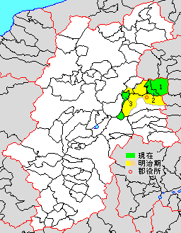
Kitasaku District, Nagano on:
[Wikipedia]
[Google]
[Amazon]
is a

district
A district is a type of administrative division that in some countries is managed by the local government. Across the world, areas known as "districts" vary greatly in size, spanning regions or county, counties, several municipality, municip ...
located in Nagano Prefecture
is a Landlocked country, landlocked Prefectures of Japan, prefecture of Japan located in the Chūbu region of Honshu. Nagano Prefecture has a population of 2,007,682 () and has a geographic area of . Nagano Prefecture borders Niigata Prefecture ...
, Japan
Japan is an island country in East Asia. Located in the Pacific Ocean off the northeast coast of the Asia, Asian mainland, it is bordered on the west by the Sea of Japan and extends from the Sea of Okhotsk in the north to the East China Sea ...
.
As of 2023, the district has an estimated population
Population is a set of humans or other organisms in a given region or area. Governments conduct a census to quantify the resident population size within a given jurisdiction. The term is also applied to non-human animals, microorganisms, and pl ...
of 41,894 with a density
Density (volumetric mass density or specific mass) is the ratio of a substance's mass to its volume. The symbol most often used for density is ''ρ'' (the lower case Greek letter rho), although the Latin letter ''D'' (or ''d'') can also be u ...
of 149 persons per km2. The total area is 281.69 km2.
Municipalities
The district consists of three towns: * Karuizawa * Miyota * Tateshina ;Notes:History

District Timeline
Recent mergers
* On April 1, 2004 - The village of Kitamimaki was merged with the town of Tōbu (from Chiisagata District) to form the new city of Tōmi. * On April 1, 2005 - The town of Mochizuki and the village of Asashina were merged with the town of Usuda (from Minamisaku District) and the old city of Saku to form the new city of Saku.References
Districts in Nagano Prefecture {{Nagano-geo-stub