Jesus Lock on:
[Wikipedia]
[Google]
[Amazon]

 Jesus Lock is a
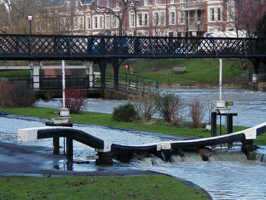
TL4459: View across Jesus Lock bridge

 Jesus Lock is a
 lock
Lock(s) may refer to:
Common meanings
*Lock and key, a mechanical device used to secure items of importance
*Lock (water navigation), a device for boats to transit between different levels of water, as in a canal
Arts and entertainment
* ''Lock ...
on the River Cam
The River Cam () is the main river flowing through Cambridge in eastern England. After leaving Cambridge, it flows north and east before joining the River Great Ouse to the south of Ely, at Pope's Corner. The total distance from Cambridge to ...
in the north of central Cambridge
Cambridge ( ) is a university city and the county town in Cambridgeshire, England. It is located on the River Cam approximately north of London. As of the 2021 United Kingdom census, the population of Cambridge was 145,700. Cambridge beca ...
, England. This is Lock No. 1 on the navigable portion of the River Cam.Jock LockWikimapia
Wikimapia is a geographic online encyclopedia project. The project implements an interactive "clickable" web map that utilizes Google Maps with a geographically-referenced wiki system, with the aim to mark and describe all geographical objects ...
. It was built in 1836 and is the only lock in the city. Jesus Green Lock Cottage, the former lock-keeper's cottage, is by the lock on Jesus Green. It is owned by the Conservators of the River Cam
The Conservators of the River Cam are the navigation authority for the River Cam in Cambridgeshire and were founded in 1702.
History
Cambridge had been a major inland port as a result of its position on the navigable River Cam for centuries, ...
and is rented out to students.
The lock is located north of Jesus Green
Jesus Green is a park in the north of central Cambridge, Cambridgeshire, England, north of Jesus College. Jesus Ditch runs along the southern edge Jesus Green. On the northern edge of Jesus Green is the River Cam, with Chesterton Road (the ...
, which itself is north of Jesus College, hence the name. To the north of Jesus Lock is Chesterton Road
Chesterton Road (part of the A1303) is a road in the north of Cambridge, England.Chest ...
(the A1303). To the east (downstream) is Victoria Avenue Bridge on Victoria Avenue and beyond that Midsummer Common, common land
Common land is land owned by a person or collectively by a number of persons, over which other persons have certain common rights, such as to allow their livestock to graze upon it, to collect wood, or to cut turf for fuel.
A person who has ...
still used for grazing
In agriculture, grazing is a method of animal husbandry whereby domestic livestock are allowed outdoors to roam around and consume wild vegetations in order to convert the otherwise indigestible (by human gut) cellulose within grass and other ...
. Close by just downstream is Jesus Green Swimming Pool, a very long outdoor lido.
The stretch of river northeast (downstream) of Jesus Lock is sometimes called the lower river. The stretch between Jesus Lock and Baits Bite Lock is much used for rowing
Rowing is the act of propelling a human-powered watercraft using the sweeping motions of oars to displace water and generate reactional propulsion. Rowing is functionally similar to paddling, but rowing requires oars to be mechanically at ...
. There are also many residential boats on this stretch, their occupants forming a community who call themselves the Camboaters. The stretch above Jesus Lock is sometimes known as the middle river.
Footbridge
Jesus Lock footbridge on the Cam links Chesterton Road withJesus Green
Jesus Green is a park in the north of central Cambridge, Cambridgeshire, England, north of Jesus College. Jesus Ditch runs along the southern edge Jesus Green. On the northern edge of Jesus Green is the River Cam, with Chesterton Road (the ...
for pedestrians next to the lock.Geograph
Geograph Britain and Ireland is a Web application, web-based project, begun in March 2005, to create a freely accessible archive of geographically located photographs of Great Britain and Ireland. Photographs in the Geograph collection are cho ...
. The bridge has metal trellis railings and a wooden surface for walking. Cyclists are advised to dismount when crossing the bridge.
The bridge was built c.1892, soon after Victoria Avenue Bridge, close by downstream at the northeast corner of Jesus Green. The next bridge to the southwest (upstream) is Magdalene Bridge
Magdalene Street is a street in the north of central Cambridge, England. It runs between Castle Street, by Castle Hill, at the junction with Northampton Street and Chesterton Lane, then Chesterton Road (the A1303), to the northwest and Br ...
.
See also
*List of bridges in Cambridge
The following is a list and brief history of the bridges in Cambridge, England, principally those over the River Cam of which there are 25, soon to be 26.
The River Cam enters Cambridge from the south west of the city and heads north past many ...
References
{{authority control Buildings and structures in Cambridge Locks of Cambridgeshire 1836 establishments in England Jesus College, Cambridge Bridges in Cambridge Bridges across the River Cam Bridges completed in 1892 River Cam