Hersbrucker Alb on:
[Wikipedia]
[Google]
[Amazon]
 The Hersbrucker Alb ("Hersbruck Jura") – also called ''Hersbrucker Schweiz'' ("Hersbruck Switzerland") or ''Pegnitz-Alb'' ("Pegnitz Jura") – is the northeastern part of the
Tourism portal for the Hersbrucker Schweiz: natural monuments
Central Uplands Regions of Bavaria Mountain ranges of Bavaria {{Bavaria-geo-stub
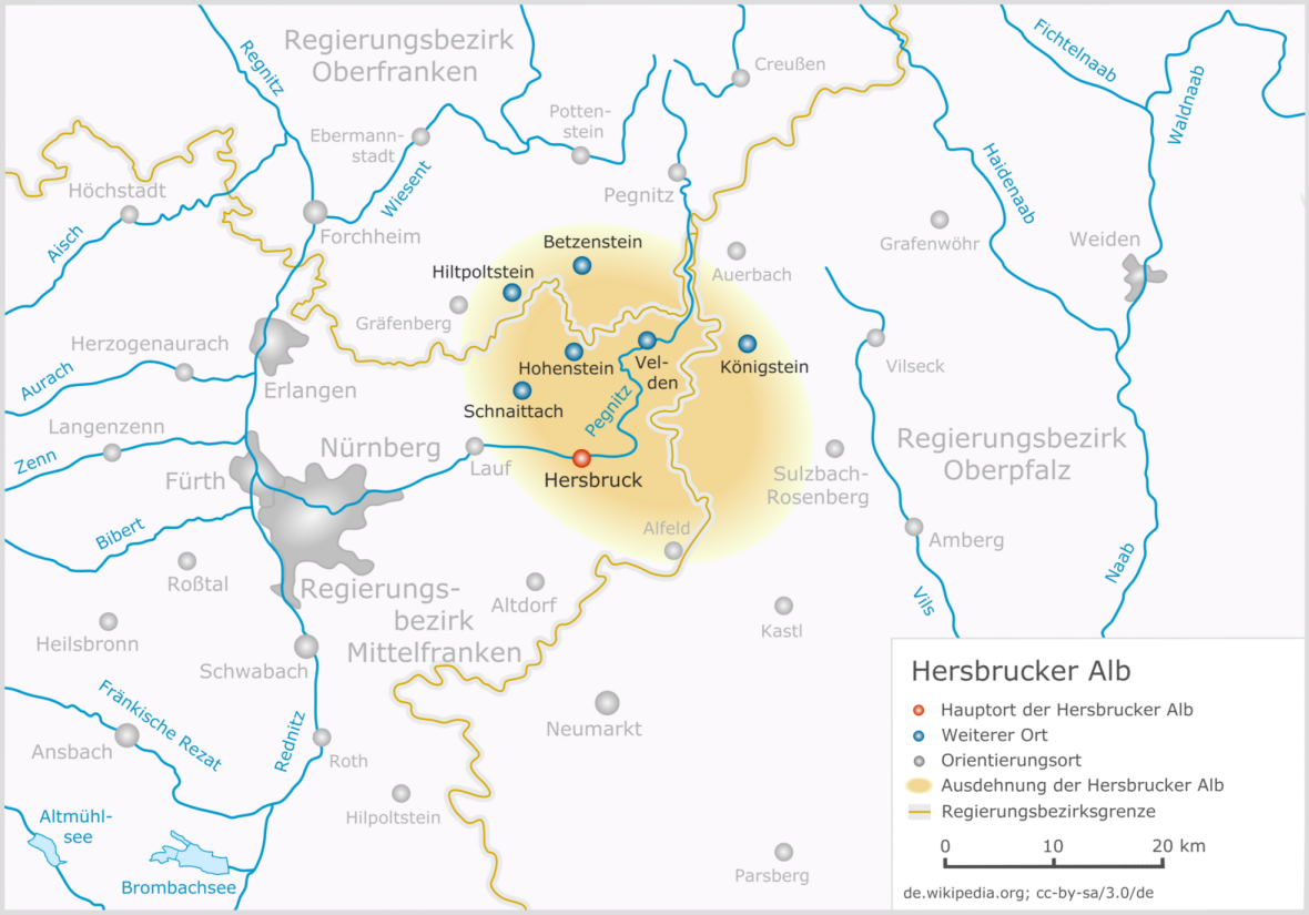
 The Hersbrucker Alb ("Hersbruck Jura") – also called ''Hersbrucker Schweiz'' ("Hersbruck Switzerland") or ''Pegnitz-Alb'' ("Pegnitz Jura") – is the northeastern part of the
 Franconian Jura
The Franconian Jura ( , , or ) is an upland in Franconia, Bavaria, Germany. Located between two rivers, the Danube in the south and the Main in the north, its peaks reach elevations of up to and it has an area of some 7053.8 km2. Emil Mey ...
near the town of Hersbruck
Hersbruck () is a small town in Middle Franconia, Bavaria, Germany, belonging to the district Nürnberger Land. It is best known for the late-gothic artwork of the Hersbruck altar, the "Hirtenmuseum" and the landscape of Hersbruck Switzerland.
...
. The River Pegnitz and its tributaries flow through the region.
Location
In the west the Hersbrucker Alb reaches the valley of theSchnaittach
Schnaittach is a market town in Middle Franconia, Bavaria, Germany.
Geography
Schnaittach is on the river Schnaittach, a tributary of the Pegnitz.
History
Schnaittach was first mentioned in 1011. Until 1806 the Christian population of ...
. It is bounded by the course of the Pegnitz and Hiltpoltstein
Hiltpoltstein is a market village in the district of Forchheim in Bavaria in Germany
Germany, officially the Federal Republic of Germany, is a country in Central Europe. It lies between the Baltic Sea and the North Sea to the north and the ...
to the west, Betzenstein
Betzenstein () is a town in the district of Bayreuth, in Bavaria, Germany. It is situated in the Franconian Switzerland, 35 km northeast of Nuremberg
Nuremberg (, ; ; in the local East Franconian dialect: ''Nämberch'' ) is the Francon ...
to the north, Auerbach in der Oberpfalz
Auerbach in der Oberpfalz (, ) is a town in the Amberg-Sulzbach district, Bavaria, Germany. In the subdivision Michelfeld there was a Michelfeld Abbey, Benedictine monastery which is now a nursing home.
Geography
It is located 45 km northeas ...
and Sulzbach-Rosenberg
Sulzbach-Rosenberg () is a municipality in the Amberg-Sulzbach district, in Bavaria, Germany. It is situated approximately 14 km northwest of Amberg, and 50 km east of Nuremberg. The town consists of two parts: Sulzbach in the west, and ...
to the east and Alfeld (Mittelfranken) to the south. Much of it lies within the Bavarian provinces of Middle Franconia
Middle Franconia (, ) is one of the three administrative regions of Franconia, Germany, in the west of Bavaria bordering the state of Baden-Württemberg. The administrative seat is Ansbach; the most populous and largest city is Nuremberg.
Subdi ...
and the Upper Palatinate
The Upper Palatinate (; , , ) is an administrative district in the east of Bavaria, Germany. It consists of seven districts and 226 municipalities, including three cities.
Geography
The Upper Palatinate is a landscape with low mountains and nume ...
; a small part is in Upper Franconia
Upper Franconia (, ) is a (administrative 'Regierungs''region 'bezirk'' of the state of Bavaria, southern Germany. It forms part of the historically significant region of Franconia, the others being Middle Franconia and Lower Franconia, wh ...
.
The Hersbrucker Alb is formed from the White Jura
The White Jurassic or White Jura ( or ''Weißjura'') in earth history refers to the upper of the three lithostratigraphic units of the South German Jurassic, the latter being understood not as a geographical, but a geological term in the sense of ...
platform of hard, brittle and karstified
Karst () is a topography formed from the dissolution of soluble carbonate rocks such as limestone and dolomite. It is characterized by features like poljes above and drainage systems with sinkholes and caves underground. There is some eviden ...
massive and Corallian Limestone
The Corallian Group or Corallian Limestone is a geologic group in England. It is predominantly a coralliferous sedimentary rock, laid down in the Oxfordian stage of the Jurassic. It is a hard variety of " coral rag". Building stones from this g ...
s and the Franconian dolomite together with their more recent depositions. Numerous cave
Caves or caverns are natural voids under the Earth's Planetary surface, surface. Caves often form by the weathering of rock and often extend deep underground. Exogene caves are smaller openings that extend a relatively short distance undergrou ...
s and a striking rock landscape have resulted in the area being referred to as "Hersbruck Switzerland" (''Hersbrucker Schweiz'', formerly ''Nürnberger Schweiz''). The Hersbrucker Alb is part of the Northern Franconian Jura climbing area. The term ''Alb'' may come from the Latin ''montes albi'' ("white mountains"). The term is however probably an old Celtic
Celtic, Celtics or Keltic may refer to:
Language and ethnicity
*pertaining to Celts, a collection of Indo-European peoples in Europe and Anatolia
**Celts (modern)
*Celtic languages
**Proto-Celtic language
*Celtic music
*Celtic nations
Sports Foot ...
word meaning "mountain meadow".
The Ossinger is the highest point of the Hersbrucker Alb.
Literature
* Eckhardt Pfeiffer: ''Hersbrucker Alb'' (2001), Pfeiffer Verlag, 2001, * Friedrich Herrmann: ''Höhlen der Fränkischen und Hersbrucker Schweiz.'' Regensburg, 1980 * Hardy Schabdach: ''Unterirdische Welten - Höhlen der Fränkischen und Hersbrucker Schweiz.'' Verlag Reinhold Lippert, Ebermannstadt, 2000Maps
* No.53 Sheet South. ''Veldensteiner Forst, Hersbrucker Alb.'' * No.72 ''Hersbrucker Alb in der Frankenalb, Pegnitz- und Hirschbachtal. ''External links
Tourism portal for the Hersbrucker Schweiz: natural monuments
Central Uplands Regions of Bavaria Mountain ranges of Bavaria {{Bavaria-geo-stub