Gatiali on:
[Wikipedia]
[Google]
[Amazon]
 Gatiali (or ''Patan Gatiali'' or ''Gatiyalian'') is a village in
 Gatiali (or ''Patan Gatiali'' or ''Gatiyalian'') is a village in
 Jhelum District
Jhelum District (Urdu and pnb, ), is partially in Pothohar Plateau, and partially in Punjab Plain of the Punjab province of Pakistan. Jhelum is one of the oldest districts of Punjab. It was established on 23 March 1849. According to the 1998 ...
, Punjab, Pakistan
Punjab (; , ) is one of the four provinces of Pakistan. Located in central-eastern region of the country, Punjab is the second-largest province of Pakistan by land area and the largest province by population. It shares land borders with the P ...
. is north of Jhelum City and South of Mangla Dam
The Mangla Dam ( ur, ) is a multipurpose dam situated on the Jhelum River in the Mirpur District of Azad Kashmir. It is the sixth-largest dam in the world. The village of Mangla, which sits at the mouth of the dam, serves as its namesake. In ...
.
Today a small village on the west Jhelum River
The Jhelum River (/dʒʰeːləm/) is a river in the northern Indian subcontinent. It originates at Verinag and flows through the Indian administered territory of Jammu and Kashmir, to the Pakistani-administered territory of Kashmir, and the ...
bank in Punjab, in fact in east of Gatiali's land there is only border of Azad Kashmir
Azad Jammu and Kashmir (; ), abbreviated as AJK and colloquially referred to as simply Azad Kashmir, is a region administered by Pakistan as a nominally self-governing entitySee:
*
*
* and constituting the western portion of the larger K ...
. Importance of this small village in the history is not known but the Road from Jhelum to Mangla on the River Jhelum's West bank Called Jhelum
Jhelum (Punjabi and ur, ) is a city on the east bank of the Jhelum River, which is located in the district of Jhelum in the north of Punjab province, Pakistan. It is the 44th largest city of Pakistan by population. Jhelum is known for pr ...
- Gatiali-Shekhupura Road (Shekhupura is a village on Mangla Dina Road where is the link).
The famous project of bridge on Jhelum River to link the Azad Kashmir
Azad Jammu and Kashmir (; ), abbreviated as AJK and colloquially referred to as simply Azad Kashmir, is a region administered by Pakistan as a nominally self-governing entitySee:
*
*
* and constituting the western portion of the larger K ...
with Pakistan directly is located near to Gatiali Village and Called Pull Patan Gatyalian.
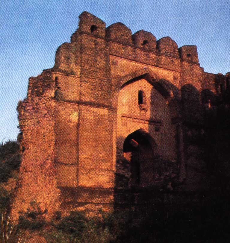
Another evidence is the Gatiali Gate in Rohtas Fort
Rohtas Fort or Rotas Ghur (Punjabi, ur, ; ''Qila Rohtas'') is a 16th-century fortress located near the city of Dina in Jhelum district of the Punjab province of Pakistan. An Afghan warlord turned Padishah, Sher Shah Suri built the fort, wh ...
. It is a single gate 9.15 metres high and 6.1 metres deep. This gate faces to the village Gatali Ford (ravine) which is called also Patan Gatiali or Gatiyalian, the important point to cross the River Jhelum for the Kashmir Valley, thus the name.
Castes and clans
Rajput
Rajput (from Sanskrit ''raja-putra'' 'son of a king') is a large multi-component cluster of castes, kin bodies, and local groups, sharing social status and ideology of genealogical descent originating from the Indian subcontinent. The term Ra ...
s of the Sohlan
Sohlan is a village of Abbottabad District in Khyber-Pakhtunkhwa province of Pakistan. It is located at 34°6'25N 73°8'0E with an altitude of . Neighbouring settlements include Dhoba, Baghati and Chhar
Chhar is a village of Abbottabad District ...
are Muslims and basic residents and proprietors of the village. Kashmiries they are living in the village since 1920. There was some evidence of presence of some Hindu (Khatri) families but at the time of the partition of India
The Partition of British India in 1947 was the Partition (politics), change of political borders and the division of other assets that accompanied the dissolution of the British Raj in South Asia and the creation of two independent dominions: ...
, they left the Village.
{{Neighbourhoods of Jhelum
Populated places in Jhelum District