Filchner–Ronne Ice Shelf on:
[Wikipedia]
[Google]
[Amazon]


 The Filchner–Ronne Ice Shelf or Ronne–Filchner Ice Shelf is an Antarctic ice shelf bordering the
/ref> In May 2021,6.2.1. Filchner-Ronne Ice Shelf Programme
. WAIS: The
A study published in ''
Big Antarctic ice sheet appears doomed; Warming climate predicted to trigger collapse of Filchner-Ronne shelf by 2100
June 2, 2012; Vol.181 #11 (p. 5)


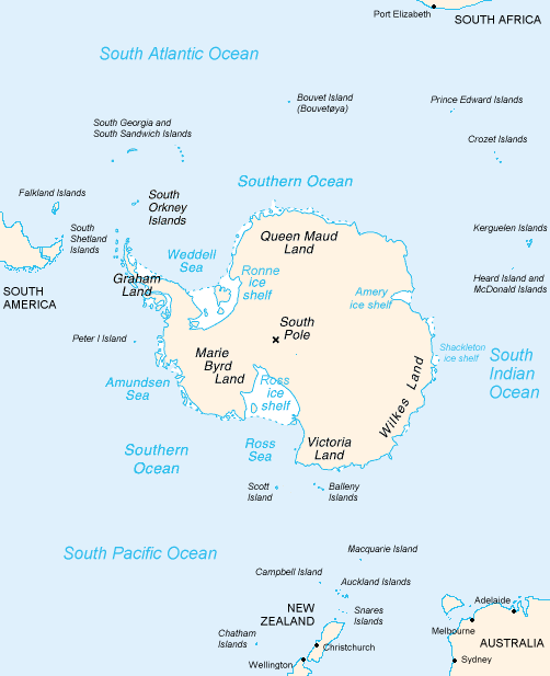
 The Filchner–Ronne Ice Shelf or Ronne–Filchner Ice Shelf is an Antarctic ice shelf bordering the
 Weddell Sea
The Weddell Sea is part of the Southern Ocean and contains the Weddell Gyre. Its land boundaries are defined by the bay formed from the coasts of Coats Land and the Antarctic Peninsula. The easternmost point is Cape Norvegia at Princess Martha C ...
.
Description
The seaward side of the Filchner–Ronneice shelf
An ice shelf is a large platform of glacial ice floating on the ocean, fed by one or multiple tributary glaciers. Ice shelves form along coastlines where the ice thickness is insufficient to displace the more dense surrounding ocean water. T ...
is divided into Eastern (Filchner) and the larger Western (Ronne) sections by Berkner Island
Berkner Island (also known as the Berkner Ice Rise or as Hubley Island) is an Antarctic ice rise, where bedrock below sea level has caused the surrounding ice sheet to create a dome. If the ice cap were removed, the island would be underwater. B ...
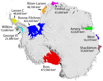
. The whole ice shelf covers some 430,000 km2, making it the second largest ice shelf in Antarctica (and on Earth), after the Ross Ice Shelf
The Ross Ice Shelf is the largest ice shelf of Antarctica (, an area of roughly and about across: about the size of France). It is several hundred metres thick. The nearly vertical ice front to the open sea is more than long, and between high ...
. It grows perpetually due to a flow of inland ice sheets. From time to time, when the shearing stresses exceed the strength of the ice, cracks form and large parts of the ice sheet separate from the ice shelf and float off and disperse as iceberg
An iceberg is a piece of fresh water ice more than long that has broken off a glacier or an ice shelf and is floating freely in open water. Smaller chunks of floating glacially derived ice are called "growlers" or "bergy bits". Much of an i ...
s. This is known as calving.
The Ronne ice shelf is the larger and western part of the Filchner–Ronne ice shelf. It is bounded on the west by the base of the Antarctic Peninsula
The Antarctic Peninsula, known as O'Higgins Land in Chile and Tierra de San Martin in Argentina, and originally as Graham Land in the United Kingdom and the Palmer Peninsula in the United States, is the northernmost part of mainland Antarctica.
...
(Graham Land
Graham Land is the portion of the Antarctic Peninsula that lies north of a line joining Cape Jeremy and Cape Agassiz. This description of Graham Land is consistent with the 1964 agreement between the British Antarctic Place-names Committee ...
with Zumberge Coast
Zumberge Coast is that portion of the southeast coast of Ellsworth Land between Cape Zumberge and the south entrance point to Hercules Inlet. Overlooking the west part of Ronne Ice Shelf, this coast was mapped by United States Geological Survey ( ...
and Orville Coast
Orville Coast is that portion of the coast of Antarctica lying west of Ronne Ice Shelf between Cape Adams and Cape Zumberge. It was discovered by the Ronne Antarctic Research Expedition (RARE), 1947–48, under Ronne, who named this coast for Capta ...
) and Ellsworth Land
Ellsworth Land is a portion of the Antarctica, Antarctic continent bounded on the west by Marie Byrd Land, on the north by the Bellingshausen Sea, on the northeast by the base of the Antarctic Peninsula, and on the east by the western margin of t ...
. Commander Finn Ronne
Finn Ronne (December 20, 1899 – January 12, 1980) was a Norwegian-born U.S. citizen and Antarctic explorer.
Background
Finn Ronne was born in Horten, in Vestfold county, Norway. His father, Martin Rønne (1861–1932), was a polar explorer ...
, USNR, leader of the Ronne Antarctic Research Expedition
The Ronne Antarctic Research Expedition (RARE) was an expedition from 1947–1948 which researched the area surrounding the head of the Weddell Sea in Antarctica.
Background
Finn Ronne led the RARE which was the final privately sponsored exp ...
(RARE) in 1947–48, discovered and photographed a strip along the entire northern portion of this ice shelf in two aircraft flights in November and December 1947. He named it the "Lassiter Shelf Ice" and gave the name "Edith Ronne Land" to the land presumed to lie south of it. In 1957–58, the US-IGY
Immunoglobulin Y (abbreviated as IgY) is a type of immunoglobulin which is the major antibody in bird, reptile, and lungfish blood. It is also found in high concentrations in chicken egg yolk. As with the other immunoglobulins, IgY is a class of pr ...
party at Ellsworth Station
Ellsworth Scientific Station (, or simply ''Estación Ellsworth'' or ''Base Ellsworth'') was a permanent, all year-round originally American, then Argentine Antarctic scientific research station named after American polar explorer Lincoln Ellswo ...
, under now Captain Ronne, determined that the ice shelf was larger than previously charted, that it extends southward to preempt most of "Edith Ronne Land
Edith Ronne Land was the unofficial name of that portion of Antarctica which is bordered by Palmer Land and Ellsworth Land to the West, Coats Land to the East, and the Filchner-Ronne Ice Shelf to the North. In December 2012, this region was offic ...
". Inasmuch as Capt. James Lassiter's name has been assigned to a coast of Palmer Land
Palmer Land () is the portion of the Antarctic Peninsula, Antarctica that lies south of a line joining Cape Jeremy and Cape Agassiz. This application of Palmer Land is consistent with the 1964 agreement between the Advisory Committee on Antarctic N ...
, the Advisory Committee on Antarctic Names
The Advisory Committee on Antarctic Names (ACAN or US-ACAN) is an advisory committee of the United States Board on Geographic Names responsible for recommending commemorative names for features in Antarctica.
History
The committee was established ...
(US-ACAN) approved the name Ronne Ice Shelf for this large ice shelf, on the basis of first sighting and exploration of the ice shelf by Ronne and parties under his leadership. The shelf is therefore named for Edith Ronne
Edith Jackie Ronne (October 13, 1919 – June 14, 2009) was an American explorer of Antarctica and the first woman in the world to be a working member of an Antarctic expedition (1947–48). The Ronne Ice Shelf was named by her husband after her ...
, the wife of Finn Ronne and RARE Expedition member.
The Filchner ice shelf is the eastern part of the Filchner–Ronne ice shelf. It is bounded on the west by Berkner Island and on the east by Coats Land
Coats Land is a region in Antarctica which lies westward of Queen Maud Land and forms the eastern shore of the Weddell Sea, extending in a general northeast–southwest direction between 20°00′W and 36°00′W. The northeast part was discover ...
. The east part of this shelf was discovered in January–February 1912 by the German Antarctic Expedition under Wilhelm Filchner
Wilhelm Filchner (13 September 1877 – 7 May 1957) was a German army officer, scientist and explorer. He conducted several surveys and scientific investigations in China, Tibet and surrounding regions, and led the Second German Antarctic Expedit ...
. Filchner named the feature for Kaiser Wilhelm Kaiser Wilhelm is a common reference to two German emperors:
* Wilhelm I, German Emperor (1797–1888)
* Wilhelm II, German Emperor (1859–1941)
Kaiser Wilhelm may also refer to:
* Kaiser Wilhelm (baseball) (1874–1936), early 20th century baseba ...
, but the Emperor requested it be named for its discoverer. The shelf is nourished primarily by the Slessor Glacier, the Recovery Glacier
The Recovery Glacier () is a glacier, at least long and wide at its mouth, flowing west along the southern side of the Shackleton Range in Antarctica.
Discovery and name
The Recovery Glacier was first seen from the air and examined from the ...
, and the Support Force Glacier
The Support Force Glacier () is a major glacier in the Pensacola Mountains, draining northward between the Forrestal Range and Argentina Range to the Filchner-Ronne Ice Shelf.
Mapping and name
The Support Force Glacier was mapped by the United ...
, all located east of Berkner Island.
In 2021, sponges
Sponges or sea sponges are primarily marine invertebrates of the animal phylum Porifera (; meaning 'pore bearer'), a basal clade and a sister taxon of the diploblasts. They are sessile filter feeders that are bound to the seabed, and ar ...
and other unidentified suspension feeders were reported to have been found growing on a boulder under the western margin of the Filchner ice shelf, close to Berkner Island, at a depth of 1,233 m (872 of which were ice), 260 km from open water.
Disintegration (calving)
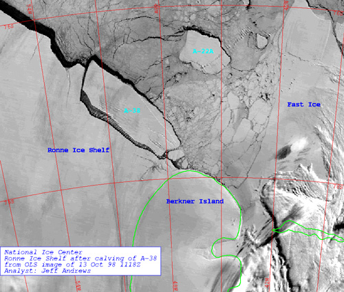
In October 1998, theiceberg A-38
A-38 was a large iceberg that split from the Filchner-Ronne Ice Shelf in Antarctica in October 1998. Soon after formation it split into two pieces, A-38A and A-38B, which drifted westwards on the Weddell Gyre. The icebergs moved north along the ...
broke off the Filchner–Ronne ice shelf. It had an extent of roughly 150 by 50 km and was thus larger than Delaware
Delaware ( ) is a U.S. state, state in the Mid-Atlantic (United States), Mid-Atlantic and South Atlantic states, South Atlantic regions of the United States. It borders Maryland to its south and west, Pennsylvania to its north, New Jersey ...
. It later broke up again into three parts. A similar-sized calving in May 2000 created an iceberg 167 by 32 km in extent, dubbed A-43 – the disintegration of this is thought to have been responsible for the November 2006 sighting of several large icebergs from the coast of the South Island
The South Island ( , 'the waters of Pounamu, Greenstone') is the largest of the three major islands of New Zealand by surface area, the others being the smaller but more populous North Island and Stewart Island. It is bordered to the north by ...
of New Zealand
New Zealand () is an island country in the southwestern Pacific Ocean. It consists of two main landmasses—the North Island () and the South Island ()—and List of islands of New Zealand, over 600 smaller islands. It is the List of isla ...
, the first time since 1931 that any icebergs had been observed from the New Zealand mainland. A large group of small icebergs (the largest some 1000 metres in length), were seen off the south-east coast of the island, with one of them drifting close enough to shore to be visible from the hills above the city of Dunedin
Dunedin ( ; ) is the second-most populous city in the South Island of New Zealand (after Christchurch), and the principal city of the Otago region. Its name comes from ("fort of Edin"), the Scottish Gaelic name for Edinburgh, the capital of S ...
. If these were indeed the remnants of this calving, then over the course of five and a half years they had travelled slowly north and also east around over half the globe, a journey of some 13,500 km.NIWA reportNational Institute of Water and Atmospheric Research
The National Institute of Water and Atmospheric Research or NIWA (), is a Crown Research Institute of New Zealand. Established in 1992, NIWA conducts research across a broad range of disciplines in the environmental sciences. It also maintai ...
From January 12 and January 13, 2010, an area of sea ice larger than the state of Rhode Island
Rhode Island ( ) is a state in the New England region of the Northeastern United States. It borders Connecticut to its west; Massachusetts to its north and east; and the Atlantic Ocean to its south via Rhode Island Sound and Block Is ...
, or one-seventh the size of Wales
Wales ( ) is a Countries of the United Kingdom, country that is part of the United Kingdom. It is bordered by the Irish Sea to the north and west, England to the England–Wales border, east, the Bristol Channel to the south, and the Celtic ...
, broke away from the Ronne–Filchner Ice Shelf and shattered into many smaller pieces. The Moderate-Resolution Imaging Spectroradiometer
The Moderate Resolution Imaging Spectroradiometer (MODIS) is a satellite-based sensor used for earth and climate measurements. There are two MODIS sensors in Geocentric orbit, Earth orbit: one on board the Terra (satellite), Terra (Earth ...
(MODIS) on NASA's Aqua
Aqua is the Latin word for water. As such, it is often used in many words which relate to water, such as aquatic life. In English, it may also refer to:
Arts
* Aqua (color), a greenish-blue color
Business
* Aqua (Chicago), an 82-story resid ...
and Terra
Terra may often refer to:
* Terra (mythology), primeval Roman goddess
* An alternate name for planet Earth, as well as the Latin name for the planet
Terra may also refer to: Geography Astronomy
* Terra (satellite), a multi-national NASA scient ...
satellites captured this event in this series of photo-like images.Rapid Sea Ice Breakup along the Ronne-Filchner Ice Shelf/ref> In May 2021,
Iceberg A-76
Iceberg A-76 was a large iceberg which briefly held the title for the world's largest floating iceberg. It calved from the Filchner–Ronne Ice Shelf in Antarctica.
A-76, effectively a piece of floating ice shelf, detached from the western s ...
broke off the northwest corner of the shelf. At 4320 km2, it is larger than Majorca
Mallorca, or Majorca, is the largest of the Balearic Islands, which are part of Spain, and the List of islands in the Mediterranean#By area, seventh largest island in the Mediterranean Sea.
The capital of the island, Palma, Majorca, Palma, i ...
, several times larger than Iceberg A-74
Iceberg A-74 is an iceberg that calved from the north side of the Antarctic Brunt Ice Shelf in February 2021. Its calving had been anticipated due to large ice rifts that opened up in September 2019 and spread in the Antarctic summer of 2020� ...
which calved in the same year, or approximately 14% the size of Belgium
Belgium, officially the Kingdom of Belgium, is a country in Northwestern Europe. Situated in a coastal lowland region known as the Low Countries, it is bordered by the Netherlands to the north, Germany to the east, Luxembourg to the southeas ...
.
The ice of the Filchner–Ronne ice shelf can be as thick as 600 m; the water below is about 1400 m deep at the deepest point.
The international Filchner–Ronne Ice Shelf Programme (FRISP) was initiated in 1973 to study the ice shelf.. WAIS: The
West Antarctic Ice Sheet
The West Antarctic Ice Sheet (WAIS) is the segment of the Antarctic ice sheet, continental ice sheet that covers West Antarctica, the portion of Antarctica on the side of the Transantarctic Mountains that lies in the Western Hemisphere. It is cla ...
Initiative.Nature
Nature is an inherent character or constitution, particularly of the Ecosphere (planetary), ecosphere or the universe as a whole. In this general sense nature refers to the Scientific law, laws, elements and phenomenon, phenomena of the physic ...
'' in 2012 by scientists from the Alfred Wegener Institute for Polar and Marine Research
The Alfred Wegener Institute, Helmholtz Centre for Polar and Marine Research (German: ''Alfred-Wegener-Institut, Helmholtz-Zentrum für Polar- und Meeresforschung'') is located in Bremerhaven, Germany, and a member of the Helmholtz Association ...
in Germany, and funded by the Ice2Sea
Ice2sea was a program of scientific research funded by the European Union'Framework 7 Programmeto study the effects of climate change on glaciation and the melting of ice caps and glaciers on sea level. The ice2sea project, a collaborative of 24 re ...
initiative, predicts the disappearance of the vast ice shelf in Antarctica by the end of the century which could – indirectly – add up to of rise of sea level each year.
See also
*Belgrano I Base
Belgrano I Base () was a permanent, all year-round Argentine Antarctic base and scientific research station, located on Piedrabuena Bay on the Filchner Ice Shelf. It was named after General Manuel Belgrano, one of the Libertadores and the creator ...
*Ellsworth Station
Ellsworth Scientific Station (, or simply ''Estación Ellsworth'' or ''Base Ellsworth'') was a permanent, all year-round originally American, then Argentine Antarctic scientific research station named after American polar explorer Lincoln Ellswo ...
* Filchner Trough
* Grand Chasms
*Weddell Gyre
The Weddell Gyre is one of the two gyres that exist within the Southern Ocean. The gyre is formed by interactions between the Antarctic Circumpolar Current (ACC) and the Antarctic Continental Shelf. The gyre is located in the Weddell Sea, and ...
References
External links
* *Big Antarctic ice sheet appears doomed; Warming climate predicted to trigger collapse of Filchner-Ronne shelf by 2100
June 2, 2012; Vol.181 #11 (p. 5)
Science News
''Science News'' (''SN'') is an American monthly magazine devoted to articles about new scientific and technical developments, typically gleaned from recent scientific and technical journals. The periodical has been described as having a scop ...
.
{{DEFAULTSORT:Filchner-Ronne Ice Shelf
British Antarctic Territory
Ice shelves of Antarctica
Argentine Antarctica
Chilean Antarctic Territory
*
Bodies of ice of Queen Elizabeth Land