Elevation Point on:
[Wikipedia]
[Google]
[Amazon]
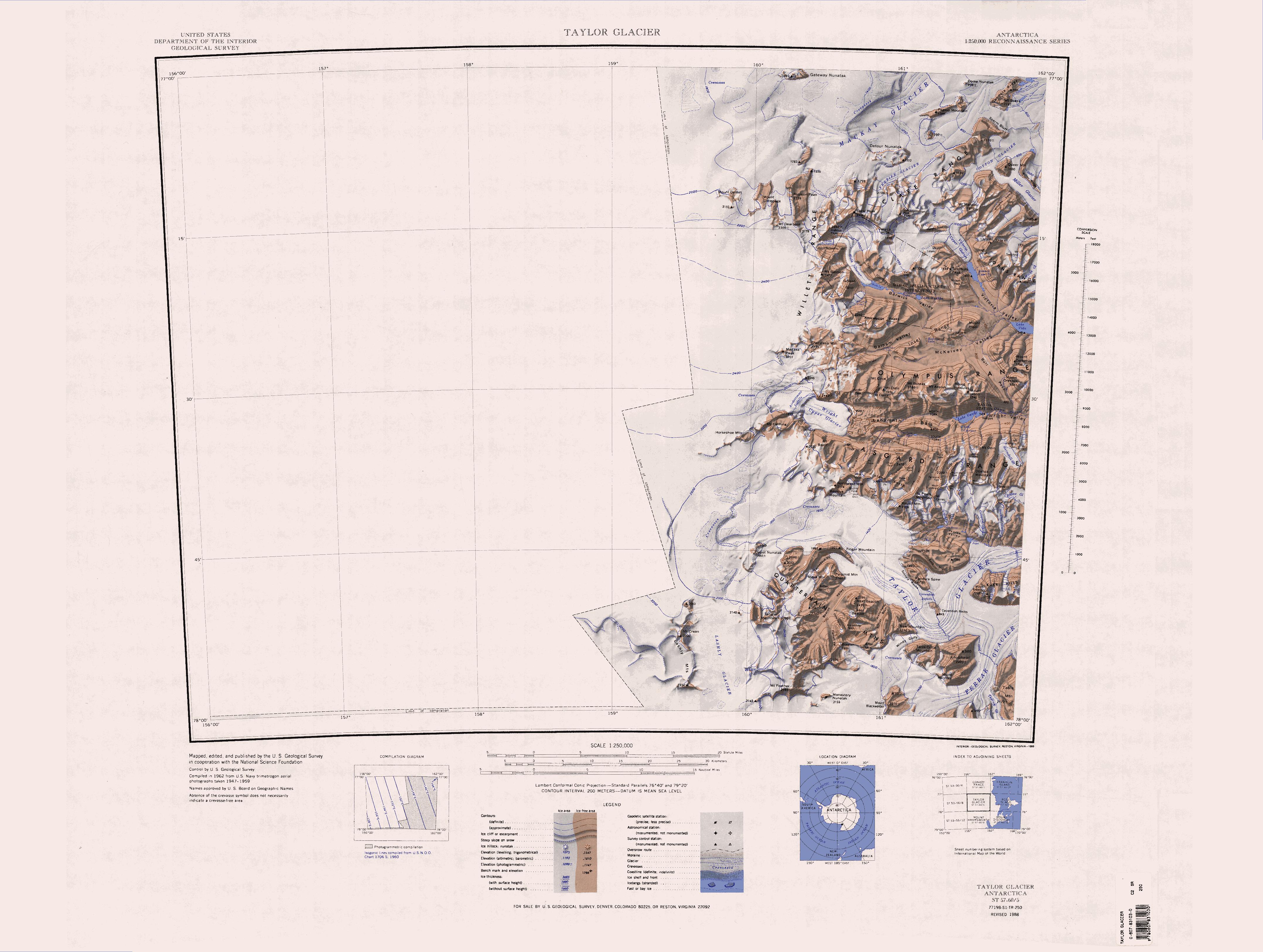
Kukri Hills () is a prominent east-west trending range, about long and over high, forming the divide between

 Peaks and other features, from west to east, include:
 .
Small alpine glacier flowing toward Lake Bonney in Taylor Valley from the Kukri Hills on the south, in Victoria Land.
Mapped by the Western Geological Party led by Taylor of the BrAE (1910–13) and named for Prof. McKenny Hughes, geologist, of Cambridge.
 .
Glacier between Marr and Hughes Glaciers, flowing from the Kukri Hills toward the east end of Lake Bonney in Taylor Valley.
Charted and named by the BrAE under Scott, 1910–13, for William J. Sollas, professor of geology at Oxford.
Ferrar Glacier
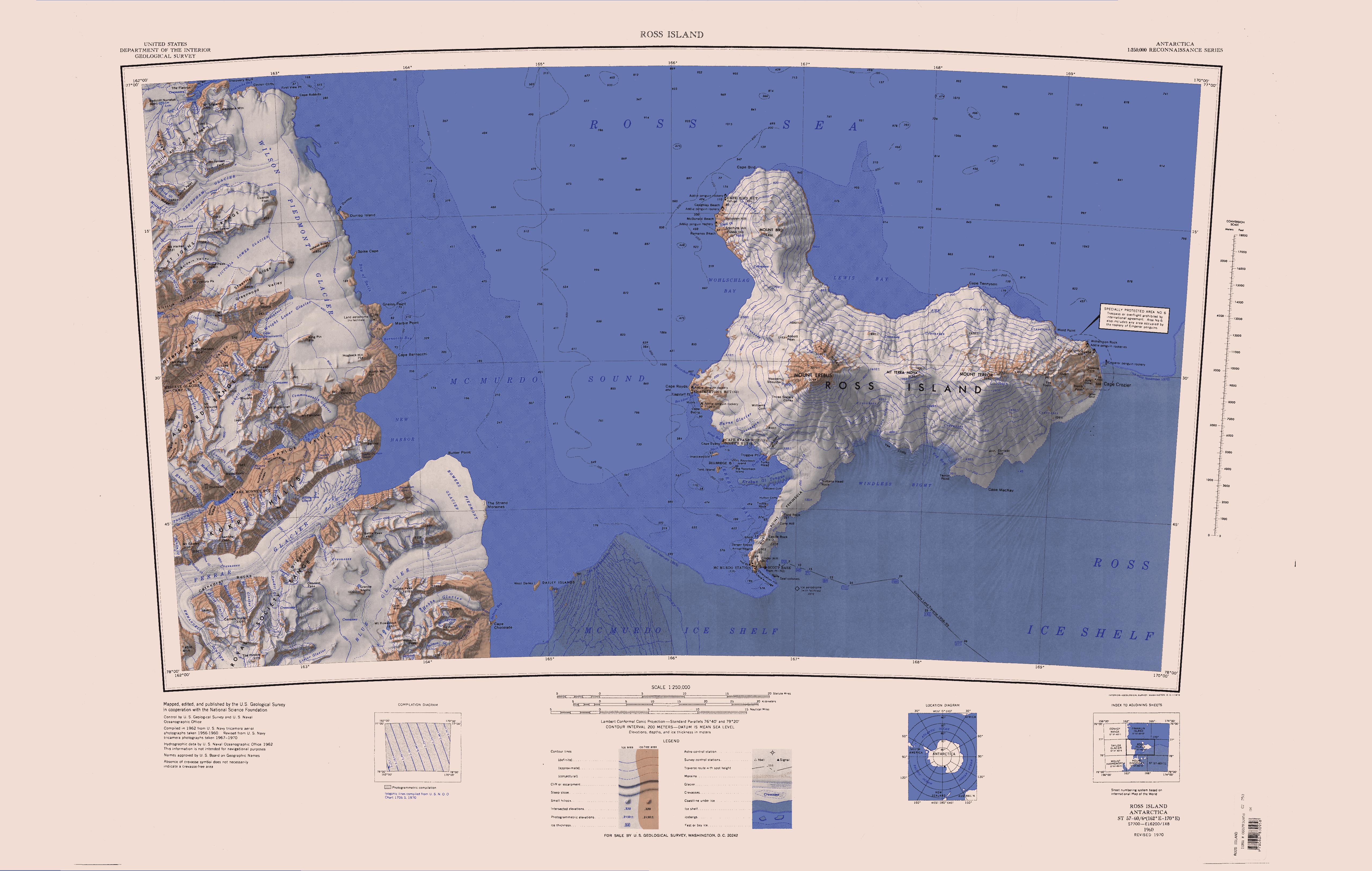
Ferrar Glacier ()is a glacier in Antarctica. It is about long, flowing from the plateau of Victoria Land west of the Royal Society Range to New Harbour in McMurdo Sound.
The glacier makes a right (east) turn northeast of Knobhead, where it whe ...
on the south and Taylor Glacier
The Taylor Glacier () is a glacier in Antarctica about long, flowing from the plateau of Victoria Land into the western end of Taylor Valley, north of the Kukri Hills.
It flows to the south of the Asgard Range. The middle part of the glacier is ...
and Taylor Valley
Taylor Valley is an ice-free valley about long, once occupied by the receding Taylor Glacier.
It lies north of the Kukri Hills between the Taylor Glacier and New Harbour in Victoria Land, Antarctica.
Taylor Valley is the southernmost of the ...
on the north, in Victoria Land
Victoria Land is a region in eastern Antarctica which fronts the western side of the Ross Sea and the Ross Ice Shelf, extending southward from about 70°30'S to 78th parallel south, 78°00'S, and westward from the Ross Sea to the edge of the Ant ...
, Antarctica.
They are south of the Asgard Range
The Asgard Range () is a mountain range in Victoria Land, Antarctica.
It divides Wright Valley from Taylor Glacier and Taylor Valley.
It is south of the Olympus Range and north of the Quartermain Mountains and the Kukri Hills.
Name
The Asga ...
, east of the Quartermain Mountains
The Quartermain Mountains ( ) are a group of exposed mountains in Antarctica, about long, typical of ice-free features of the McMurdo Dry Valleys, Victoria Land.
They are east of the Lashly Mountains, south of the Asgard Range, west of the Kukr ...
and north of the Royal Society Range
The Royal Society Range () is a majestic range of mountains in Victoria Land, Antarctica, rising to along the west shore of McMurdo Sound between the Koettlitz, Skelton and Ferrar Glaciers.
They are south of the Kukri Hills, southeast of the Q ...
.
The hills were discovered by the Discovery Expedition
The ''Discovery'' Expedition of 1901–1904, known officially as the British National Antarctic Expedition, was the first official British exploration of the Antarctic regions since the voyage of James Clark Ross sixty years earlier (1839–184 ...
(1901–04) and probably so named because its shape resembles that of the Kukri
The kukri () or khukuri (, ) is a type of knife or short sword with a distinct recurve in its blade that originated in the Indian subcontinent. It serves multiple purposes as a melee weapon and also as a regular cutting/chopping tool throughout ...
, a Gurkha knife.
Topography
The western tip of the Kukri Hills is Mount Brearley, where theTaylor Glacier
The Taylor Glacier () is a glacier in Antarctica about long, flowing from the plateau of Victoria Land into the western end of Taylor Valley, north of the Kukri Hills.
It flows to the south of the Asgard Range. The middle part of the glacier is ...
separates from the Ferrar Glacier
Ferrar Glacier ()is a glacier in Antarctica. It is about long, flowing from the plateau of Victoria Land west of the Royal Society Range to New Harbour in McMurdo Sound.
The glacier makes a right (east) turn northeast of Knobhead, where it whe ...
, with the Taylor Glacier flowing north east and the Ferrar glacier flowing southeast.
The hills stretch east with, with prominent peaks from west to east including Mount Coates, Sentinel Peak, Bonney Riegel, Nussbaum Regel, Andrew's Ridge, and Mount Barnes where the hills terminate in New Harbor.
The Taylor Glacier and Taylor Valley run along the north side, while the Ferrar Glacier runs along the south side.
There are several small glaciers in the hills, including Borns Glacier, Calkin Glacier, Hughes Glacier, Sollas Glacier, Marr Glacier, Calamon Glacier, Howard Glacier, Crescent Glacier and Wales Glacier.
Features

 Peaks and other features, from west to east, include:
Elevation Point
. A bold rock point which forms the west end of Kukri Hills, overlooking Taylor Glacier. The name is one of a group in the area associated with surveying applied by NZGB in 1993.Eyeglass Cirque
Acirque
A (; from the Latin word ) is an amphitheatre-like valley formed by Glacier#Erosion, glacial erosion. Alternative names for this landform are corrie (from , meaning a pot or cauldron) and ; ). A cirque may also be a similarly shaped landform a ...
east of South America Glacier on the southern cliffs of the Kukri Hills.
The name is one of a group in the area associated with surveying
Surveying or land surveying is the technique, profession, art, and science of determining the land, terrestrial Plane (mathematics), two-dimensional or Three-dimensional space#In Euclidean geometry, three-dimensional positions of Point (geom ...
applied in 1993 by the New Zealand Geographic Board
The New Zealand Geographic Board Ngā Pou Taunaha o Aotearoa (NZGB) is the authority over geographical and hydrographic names within New Zealand and its territorial waters. This includes the naming of small urban settlements, localities, mounta ...
; "eyeglass" refers to the eyepiece of a surveying telescope
A telescope is a device used to observe distant objects by their emission, Absorption (electromagnetic radiation), absorption, or Reflection (physics), reflection of electromagnetic radiation. Originally, it was an optical instrument using len ...
..
Mount Brearley
. A sharp peak, high, which is the westernmost summit of the Kukri Hills. Named by the Western Journey Party, led byThomas Griffith Taylor
Thomas Griffith "Grif" Taylor (1 December 1880 – 5 November 1963) was an English-born geographer, anthropologist and world explorer. He was a survivor of Captain Robert Scott's Terra Nova Expedition to Antarctica (1910–1913). Taylor was a ...
, of the British Antarctic Expedition, 1910–13.
Mount Coates
Peak, high, just east of Borns Glacier in the Kukri Hills. Named by the Western Journey Party, led by Taylor, of the BrAE, 1910–13.Sentinel Peak
. A conspicuous, pointed peak over high, standing at the north side ofFerrar Glacier
Ferrar Glacier ()is a glacier in Antarctica. It is about long, flowing from the plateau of Victoria Land west of the Royal Society Range to New Harbour in McMurdo Sound.
The glacier makes a right (east) turn northeast of Knobhead, where it whe ...
and forming the highest point in the south-central part of the Kukri Hills.
Discovered and named by the ''Discovery'' expedition 1901–04 under Scott.
Duff Peak
. A peak east-southeast of Sentinel Peak, rising to at the head of Hughes Glacier in Kukri Hills. Named in 1992 by US-ACAN after Roger S. Duff (d. 1978), for 30 years director of the Canterbury Museum, Christchurch, New Zealand. To celebrate the Museum's centenary in 1970, a Hundredth Anniversary Wing was planned which would incorporate a National Antarctic Exhibition, Research and Reference Center. A landmark of Dr. Duff's administration, the Antarctic wing was opened on March 4, 1977.Rahi Peak
. A prominentmountain
A mountain is an elevated portion of the Earth's crust, generally with steep sides that show significant exposed bedrock. Although definitions vary, a mountain may differ from a plateau in having a limited summit area, and is usually higher t ...
rising to between the head of Moa Glacier and Goldman Glacier. The word "rahi" is Māori
Māori or Maori can refer to:
Relating to the Māori people
* Māori people of New Zealand, or members of that group
* Māori language, the language of the Māori people of New Zealand
* Māori culture
* Cook Islanders, the Māori people of the Co ...
in origin, meaning "big". The name was applied by the New Zealand Geographic Board
The New Zealand Geographic Board Ngā Pou Taunaha o Aotearoa (NZGB) is the authority over geographical and hydrographic names within New Zealand and its territorial waters. This includes the naming of small urban settlements, localities, mounta ...
(NZGB) in 1998.
Young Hill
. An ice-free hill about high, northeast of Hallam Peak. It was named by theNew Zealand Geographic Board
The New Zealand Geographic Board Ngā Pou Taunaha o Aotearoa (NZGB) is the authority over geographical and hydrographic names within New Zealand and its territorial waters. This includes the naming of small urban settlements, localities, mounta ...
(NZGB) in 1998 for New Zealand
New Zealand () is an island country in the southwestern Pacific Ocean. It consists of two main landmasses—the North Island () and the South Island ()—and List of islands of New Zealand, over 600 smaller islands. It is the List of isla ...
ornithologist Euan C. Young, whose Antarctic research spanned 30 years, beginning in the 1959–60 field season.
Hallam Peak
. A distinctive rock peak in the Kukri Hills. The peak rises to between the heads of Von Guerard Glacier and Aiken Glacier and provides an unobstructed view of the Lake Fryxell locality of Taylor Valley. Named by Advisory Committee on Antarctic Names (US-ACAN) (1997) after Dr. Cheryl A. Hallam, geographer, U.S. Geological Survey (USGS), who specializes in geographic information systems; worked four summer seasons in Antarctica, 1994–95, 1995–96, 1996–97 and 1999–00.Mount Barnes
. A peak, high, surmounting the west-central side of New Harbour and marking the east end of the Kukri Hills. Discovered by the ''Discovery'' expedition, 1901–04, underRobert Falcon Scott
Captain Robert Falcon Scott (6 June 1868 – ) was a British Royal Navy officer and explorer who led two expeditions to the Antarctic regions: the Discovery Expedition, ''Discovery'' expedition of 1901–04 and the Terra Nova Expedition ...
, and named New Harbour Heights.
It was renamed Mount Barnes after a Canadian ice physicist by Scott's second expedition, the British Antarctic Expedition, 1910–13.
Glaciers
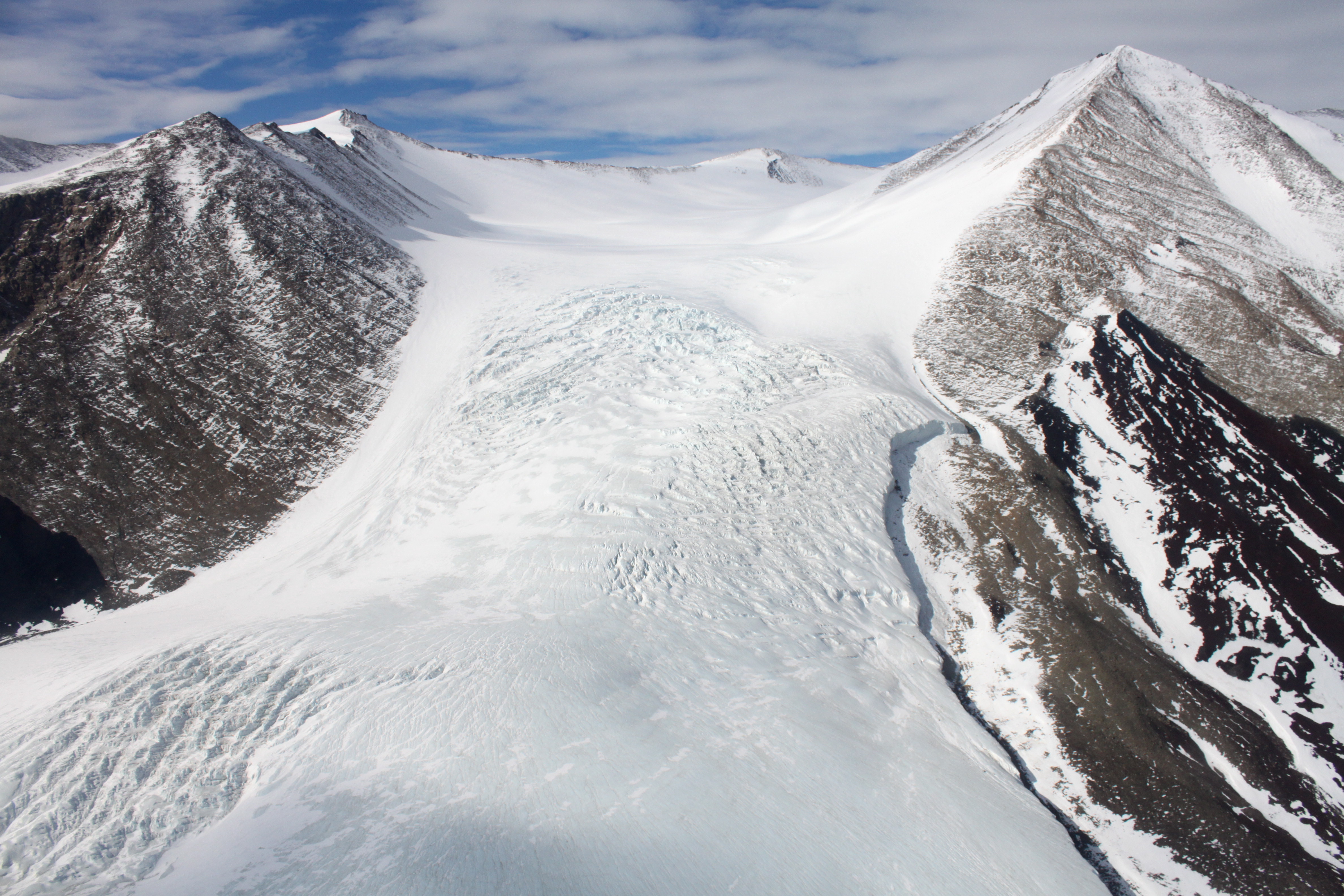
There are a number of small glaciers, mostly flowing north towards Taylor Valley. Most do not reach the valley floor. From west to east they are:South America Glacier
. Small glacier near the southwest corner of the Kukri Hills. The ice hangs down a cliff 2,000 m high, and takes a form similar to the continent for which it is named. Named by the Western Journey Party, led by Taylor, of the BrAE, 1910–13.Borns Glacier
. Glacier immediately W of Mount Coates, flowing north from the Kukri Hills. Charted by the BrAE under Scott, 1910–13. Named by the US-ACAN for Harold W. Borns, Jr., USARP geologist who made investigations in the area during 1960–61.Hughes Glacier
 .
Small alpine glacier flowing toward Lake Bonney in Taylor Valley from the Kukri Hills on the south, in Victoria Land.
Mapped by the Western Geological Party led by Taylor of the BrAE (1910–13) and named for Prof. McKenny Hughes, geologist, of Cambridge.
Sollas Glacier
 .
Glacier between Marr and Hughes Glaciers, flowing from the Kukri Hills toward the east end of Lake Bonney in Taylor Valley.
Charted and named by the BrAE under Scott, 1910–13, for William J. Sollas, professor of geology at Oxford.
Marr Glacier
. Glacier west of Goldman Glacier, flowing north from the Kukri Hills into Taylor Valley. Charted by the BrAE under Scott, 1910–13, who it appears also applied the name.Moa Glacier
. A valley glacier between Marr Glacier and Goldman Glacier in Kukri Hills. It flows north into Taylor Valley but terminates midway down the south wall of the valley. Named by New Zealand Geographic Board (NZGB) (1998) after an extinct New Zealand bird.Goldman Glacier
. Glacier east of Marr Glacier, flowing north from the Kukri Hills into Taylor Valley. Named by the US-ACAN for USARP biologist Charles R. Goldman, who made studies in the area in the 1962–63 season.Kitticarrara Glacier
. Short, steep glacier south of Howard Glacier in the Kukri Hills, flowing east-southeast into Ferrar Glacier. }Named by the Western Journey Party, led by Taylor, of the BrAE, 1910–13. The name was suggested by F. Debenham after a sheep station in New South Wales.Howard Glacier
. Small alpine glacier just west of Crescent Glacier, flowing into Taylor Valley on the north from the Kukri Hills. The glacier was studied in December 1957 by U.S. geologist T.L. Péwé, who named it for Arthur D. Howard, geomorphologist of Stanford University, and glaciologist in Antarctica during USN OpHjp, 1946–47.Crescent Glacier
. Small alpine glacier just east of Howard Glacier in the Kukri Hills, flowing north into Taylor Valley. The glacier was studied by U.S. geologist Troy L. Péwé in December 1957, and was so named by him because of its crescent shape when viewed from the floor of Taylor Valley.Von Guerard Glacier
. A glacier between Crescent Glacier and Aiken Glacier on the north slope of Kukri Hills. Named by Advisory Committee on Antarctic Names (US-ACAN) (1997) from association with Von Guerard Creek, which flows N from this glacier into Taylor Valley.Aiken Glacier
. A small glacier between Von Guerard Glacier and Wales Glacier on the N slope of Kukri Hills. Named by the Advisory Committee on Antarctic Names (US-ACAN) (1997) from association with Aiken Creek, which flows north from this glacier into Taylor Valley.Wales Glacier
. Short alpine glacier just west of Mount Barnes at the east end of the Kukri Hills. It drains north into Taylor Valley. Named.by the BrAE (1910–13) under Scott.Dun Glacier
. A short, steep tributary to the Ferrar Glacier. It descends the southern side of Kukri Hills midway between Mount Coates and Sentinel Peak. Named by the Western Journey Party led by Griffith Taylor of the BrAE (1910–13) under Scott.Double Curtain Glacier
. Small glacier on the south slope of the Kukri Hills, just southwest of Mount Barnes, flowing toward the mouth of Ferrar Glacier. Mapped by the BrAE under Scott, 1910–13, and so named by them because of its shape.References
Sources
* * * * * * * * * *{{Include-USGov , agency=United States Geological Survey Mountains of Victoria Land McMurdo Dry Valleys