D23 Road (Croatia) on:
[Wikipedia]
[Google]
[Amazon]


 D23 state road, connects cities and towns of


 D23 state road, connects cities and towns of
 Duga Resa
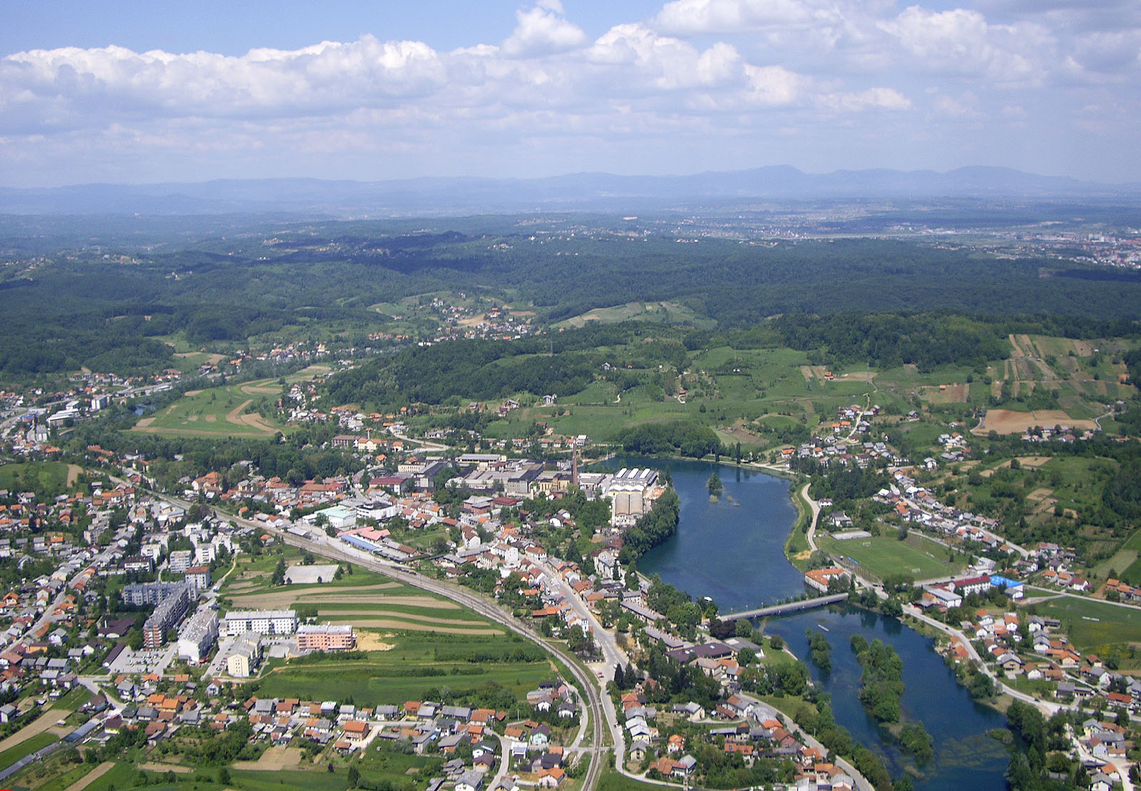
Duga Resa is a town in Karlovac County, Croatia. It is located about 65 km southwest of Zagreb and 100 km east of Rijeka.
Name
The earliest reference to Duga Resa is from the year 1380. There are several theories on how the then-villag ...
, Josipdol
Josipdol is a village and municipality in Karlovac County, Croatia. It is part of Lika region.
Geography
Josipdol is situated in the Ogulin-Plaški valley which together with Lika and Gorski Kotar forms Mountainous Croatia. The town is located ...
and Senj
Senj is a town on the upper Adriatic coast in Croatia, in the foothills of the Mala Kapela and Velebit mountains.
The symbol of the town is the Nehaj Fortress () which was completed in 1558. For a time this was the seat of the Uskoks, who were ...
, to the state road network of Croatia, and most notably to A1 motorway in Žuta Lokva
Žuta Lokva is a village in Croatia
Croatia, officially the Republic of Croatia, is a country in Central Europe, Central and Southeast Europe, on the coast of the Adriatic Sea. It borders Slovenia to the northwest, Hungary to the northeast ...
interchange, as well as two major state roads - D3 and D8, located at the northern terminus and the southern terminus of the road respectively. The road is long. The route comprises a significant number of urban intersections, in segments of the road running through Duga Resa and Senj.
The D23 state road runs parallel to a section of the A1 motorway between Karlovac
Karlovac () is a city in central Croatia. In the 2021 census, its population was 49,377.
Karlovac is the administrative centre of Karlovac County. The city is located southwest of Zagreb and northeast of Rijeka, and is connected to them via the ...
and Žuta Lokva
Žuta Lokva is a village in Croatia
Croatia, officially the Republic of Croatia, is a country in Central Europe, Central and Southeast Europe, on the coast of the Adriatic Sea. It borders Slovenia to the northwest, Hungary to the northeast ...
interchanges, thus serving as an alternate or backup route for the motorway. Additionally, A7 motorway route is planned along the D23 road between Senj
Senj is a town on the upper Adriatic coast in Croatia, in the foothills of the Mala Kapela and Velebit mountains.
The symbol of the town is the Nehaj Fortress () which was completed in 1558. For a time this was the seat of the Uskoks, who were ...
and Žuta Lokva. Once that motorway is completed, the D23 road shall run parallel to either A1 or A7 motorway along its entire length.
The road, as well as all other state roads in Croatia, is managed and maintained by Hrvatske ceste
Hrvatske ceste (lit. ''Croatian roads'') is a Croatian state-owned company pursuant to provisions of the Croatian Public Roads Act ( enacted by the Parliament of the Republic of Croatia.
The tasks of the company are defined by the Public Roads A ...
, a state-owned company.
History
Vratnik pass, currently a part of the D23 road, was already in use during Roman time as asalt road
A salt road (also known as a salt route, salt way, saltway, or salt trading route) refers to any of the Prehistory, prehistoric and Recorded history, historical trade routes by which essential salt was transported to regions that lacked it.
Fro ...
,
and it became important for timber and other goods in the Middle Ages. However, the first well documented road built along the route was ''Via Josephina'' named after Joseph II, Holy Roman Emperor
Joseph II (13 March 1741 – 20 February 1790) was Holy Roman Emperor from 18 August 1765 and sole ruler of the Habsburg monarchy from 29 November 1780 until his death. He was the eldest son of Empress Maria Theresa and her husband, Francis I, ...
who commissioned its construction in 1775. Latin inscriptions carved in rock along the original Via Josephina route completed in 1779 testify that the Emperor travelled through the Vratnik pass on horseback when he realized that the route between Senj
Senj is a town on the upper Adriatic coast in Croatia, in the foothills of the Mala Kapela and Velebit mountains.
The symbol of the town is the Nehaj Fortress () which was completed in 1558. For a time this was the seat of the Uskoks, who were ...
, as a major fortress on Adriatic
The Adriatic Sea () is a body of water separating the Italian Peninsula from the Balkans, Balkan Peninsula. The Adriatic is the northernmost arm of the Mediterranean Sea, extending from the Strait of Otranto (where it connects to the Ionian Se ...
coast, and the hinterland was nearly impassable. Legend has it that this happened when he fell from his horse near Vratnik Pass. Even though the incident is impossible to verify, the town of Josipdol
Josipdol is a village and municipality in Karlovac County, Croatia. It is part of Lika region.
Geography
Josipdol is situated in the Ogulin-Plaški valley which together with Lika and Gorski Kotar forms Mountainous Croatia. The town is located ...
to the east of the mountain pass is named after the Holy Roman Emperor.
In 1775, Joseph II indeed commissioned construction of the route, exactly long, from Vinko Struppi
Vinko is a masculine name related to Vincent, and may refer to:
Given name
* Frane Vinko Golem (1938–2007), Croatian diplomat and politician
*Vinko Begović (born 1948), Croatian football coach
* Vinko Bogataj (born 1950), former ski jumper fro ...
, a military engineer, and the road, named after the Emperor, was completed in 1779. The original route comprised very steep sections and 20% inclines were not uncommon. There was even one climb at a 30% grade. Because of this the road was modified and extended by , in order to remove such steep sections. The first reconstruction was carried out as early as late 18th century, and another one between 1833 and 1845 managed by Field Marshal Josef Philipp Vukassovich
Baron Josef Philipp Vukassovich (; 1755 – 9 August 1809) was a Croatian soldier who joined the army of Habsburg monarchy and fought against both Ottoman Empire and the First French Republic. During the French Revolutionary Wars, he comma ...
() and Josip Kajetan Knežić Josip () is a male given name largely found among Croats and Slovenes, a cognate of Joseph.
In Croatia, the name Josip was the second most common masculine given name in the decades up to 1959, and has stayed among the top ten most common ones thro ...
respectively. Subsequent modifications were not as significant. The road was paved in 1950, when the last minor modifications of the route were executed.
The route was distinguished by mile markers along the route, an obelisk in Karlovac
Karlovac () is a city in central Croatia. In the 2021 census, its population was 49,377.
Karlovac is the administrative centre of Karlovac County. The city is located southwest of Zagreb and northeast of Rijeka, and is connected to them via the ...
marking the beginning of the road and a specially built gate in Senj
Senj is a town on the upper Adriatic coast in Croatia, in the foothills of the Mala Kapela and Velebit mountains.
The symbol of the town is the Nehaj Fortress () which was completed in 1558. For a time this was the seat of the Uskoks, who were ...
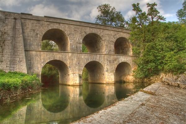
marking its end. Most remarkably the original road included a stone bridge across three spans in Tounj
Tounj is a village and a municipality in Karlovac County, Croatia.
In the 2011 census, the total population was 1,150, in the following settlements:
The fountain near the bridge has provided water continuously since 1847 without interruption a ...
, which was expanded during the reconstruction of 1845 and now has two levels. The upper level was destroyed during World War II
World War II or the Second World War (1 September 1939 – 2 September 1945) was a World war, global conflict between two coalitions: the Allies of World War II, Allies and the Axis powers. World War II by country, Nearly all of the wo ...
, but it was rebuilt in the 1950s.
Traffic volume
Traffic is regularly counted and reported byHrvatske ceste
Hrvatske ceste (lit. ''Croatian roads'') is a Croatian state-owned company pursuant to provisions of the Croatian Public Roads Act ( enacted by the Parliament of the Republic of Croatia.
The tasks of the company are defined by the Public Roads A ...
, operator of the road. Substantial variations between annual (AADT
Annual average daily traffic (AADT) is a measure used primarily in transportation planning, transportation engineering and retail location selection. Traditionally, it is the total volume of vehicle traffic of a highway or road for a year divided ...
) and summer (ASDT) traffic volumes are attributed to the fact that the road serves as a connection to A1 motorway and D8 state road carrying substantial tourist traffic.
Road junctions and populated areas
See also
*Highways in Croatia
Highways in Croatia are the main transport network in Croatia.
The Croatian classification includes several categories of highways:
* The main #Motorways, motorway routes are prefixed with an A (for ''autocesta'') followed by one or two digits ...
* Autocesta Rijeka - Zagreb
Highways in Croatia are the main transport network in Croatia.
The Croatian classification includes several categories of highways:
* The main #Motorways, motorway routes are prefixed with an A (for ''autocesta'') followed by one or two digits ...
* Hrvatske autoceste
Hrvatske autoceste (HAC) or Croatian Motorways Ltd is a Croatian state-owned limited liability company tasked with management, construction and maintenance of motorways in Croatia pursuant to provisions of the Croatian Public Roads Act () enacted ...
Maps
Sources
{{State roads in Croatia D023 D023 D023