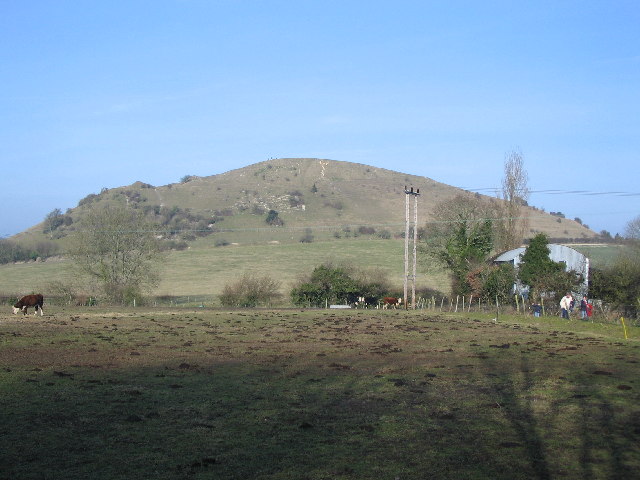
Cley Hill on:
[Wikipedia]
[Google]
[Amazon]
 Cley Hill () is a prominent hill to the west of
 There is a legend that the hill was formed by the devil, when he dropped a sack of earth with which he had planned to bury the town of
Natural England website
(SSSI information)
SSSI boundary at Defras Magic Map website
Sites of Special Scientific Interest in Wiltshire Sites of Special Scientific Interest notified in 1975 Hills of Wiltshire Hill forts in Wiltshire National Trust properties in Wiltshire Scheduled monuments in Wiltshire {{England-SSSI-stub
 Cley Hill () is a prominent hill to the west of
 Warminster
Warminster () is a historic market town and Civil parishes in England, civil parish in south-west Wiltshire, England, on the western edge of Salisbury Plain. The parish had a population of 18,173 in 2021.
The name ''Warminster'' occurs first i ...
in Wiltshire
Wiltshire (; abbreviated to Wilts) is a ceremonial county in South West England. It borders Gloucestershire to the north, Oxfordshire to the north-east, Berkshire to the east, Hampshire to the south-east, Dorset to the south, and Somerset to ...
, England. Its summit has a commanding view of the Wiltshire / Somerset county boundary, at elevation. The land is in Corsley parish and is owned by the National Trust
The National Trust () is a heritage and nature conservation charity and membership organisation in England, Wales and Northern Ireland.
The Trust was founded in 1895 by Octavia Hill, Sir Robert Hunter and Hardwicke Rawnsley to "promote the ...
.
A area of chalk grassland at Cley Hill was notified as a biological Site of Special Scientific Interest
A Site of Special Scientific Interest (SSSI) in Great Britain, or an Area of Special Scientific Interest (ASSI) in the Isle of Man and Northern Ireland, is a conservation designation denoting a protected area in the United Kingdom and Isle ...
in 1975. The land is managed by the National Trust, having been donated to the charity in 1954 by the 6th Marquess of Bath.
Archaeological features include a large univallate Iron Age
The Iron Age () is the final epoch of the three historical Metal Ages, after the Chalcolithic and Bronze Age. It has also been considered as the final age of the three-age division starting with prehistory (before recorded history) and progre ...
hill fort
A hillfort is a type of fortification, fortified refuge or defended settlement located to exploit a rise in elevation for defensive advantage. They are typical of the late Bronze Age Europe, European Bronze Age and Iron Age Europe, Iron Age. So ...
, two bowl barrow
A bowl barrow is a type of burial mound or tumulus. A barrow is a mound of earth used to cover a tomb. The bowl barrow gets its name from its resemblance to an upturned bowl. Related terms include ''cairn circle'', ''cairn ring'', ''howe'', ''ker ...
s and medieval strip lynchets. In 1812, local antiquarian
An antiquarian or antiquary () is an aficionado or student of antiquities or things of the past. More specifically, the term is used for those who study history with particular attention to ancient artefacts, archaeological and historic si ...
Sir Richard Hoare attempted to excavate the mound at the top of the hill – leaving a hole which is still visible – but found that it had been looted by grave robbers.
The south west side of the hill was quarried
A quarry is a type of open-pit mining, open-pit mine in which dimension stone, rock (geology), rock, construction aggregate, riprap, sand, gravel, or slate is excavated from the ground. The operation of quarries is regulated in some juri ...
significantly in the 19th century.
Mythology
 There is a legend that the hill was formed by the devil, when he dropped a sack of earth with which he had planned to bury the town of
 Devizes
Devizes () is a market town and civil parish in Wiltshire, England. It developed around Devizes Castle, an 11th-century Norman architecture, Norman castle, and received a charter in 1141. The castle was besieged during the Anarchy, a 12th-cent ...
. He had retrieved the earth from Somerset and was travelling to Devizes when he stopped to ask an old man the distance to the town. The man replied that he had been walking for years to reach Devizes, so the devil abandoned his plan.
In 1924, V.S. Manley wrote in his book, ''Folklore of the Warminster District: a supplement to the History of Warminster and the Official Guide'':
Since the 1965 sighting of the " Warminster thing", Cley Hill has been a hotspot of UFO sightings and crop circles
A crop circle, crop formation, or corn circle is a pattern created by flattening a crop, usually a cereal. The term was first coined in the early 1980s. Crop circles have been described as all falling "within the range of the sort of thing ...
. Sightings were documented in 1967, 1996, 2001, 2005 and 2017.
References
External links
Natural England website
(SSSI information)
SSSI boundary at Defras Magic Map website
Sites of Special Scientific Interest in Wiltshire Sites of Special Scientific Interest notified in 1975 Hills of Wiltshire Hill forts in Wiltshire National Trust properties in Wiltshire Scheduled monuments in Wiltshire {{England-SSSI-stub