Cape Bellue on:
[Wikipedia]
[Google]
[Amazon]
 Cape Bellue is a
Cape Bellue
on
Cape Bellue
on AADC website
Cape Bellue
on
headland
A headland, also known as a head, is a coastal landform, a point of land usually high and often with a sheer drop, that extends into a body of water. It is a type of promontory. A headland of considerable size often is called a cape.Whittow, Joh ...
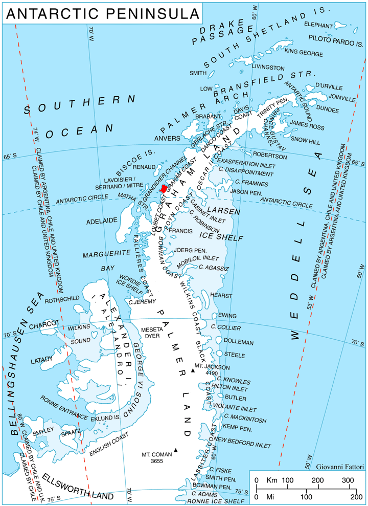
on the north side of the entrance to Darbel Bay, which forms the west extremity of Stresher Peninsula on the west coast of Graham Land
Graham Land is the portion of the Antarctic Peninsula that lies north of a line joining Cape Jeremy and Cape Agassiz. This description of Graham Land is consistent with the 1964 agreement between the British Antarctic Place-names Committee a ...
, Antarctica
Antarctica () is Earth's southernmost and least-populated continent. Situated almost entirely south of the Antarctic Circle and surrounded by the Southern Ocean, it contains the geographic South Pole. Antarctica is the fifth-largest co ...
. It separates Graham Coast
Graham Coast is the portion of the west coast of Graham Land in Antarctic Peninsula, extending 172 km between Cape Bellue to the southwest and Cape Renard to the northeast.
The coast is named after Sir James Graham, First Lord of the Admir ...
to the northeast from Loubet Coast
Loubet Coast is the portion of the west coast of Graham Land in Antarctic Peninsula, extending 158 km between Cape Bellue to the northeast and Bourgeois Fjord to the southwest. South of Loubet Coast is Fallières Coast, north is Graham Coast. ...
to the southwest. Discovered by the French Antarctic Expedition
The French Antarctic Expedition is any of several French expeditions in Antarctica.
First expedition
In 1772, Yves-Joseph de Kerguelen-Trémarec and the naturalist Jean Guillaume Bruguière sailed to the Antarctic region in search of the fabl ...
, 1908–10, under Charcot, and named by him for Admiral Bellue, Superintendent of the Dockyard at Cherbourg
Cherbourg (; , , ), nrf, Chèrbourg, ) is a former commune and subprefecture located at the northern end of the Cotentin peninsula in the northwestern French department of Manche. It was merged into the commune of Cherbourg-Octeville on 28 ...
, France
France (), officially the French Republic ( ), is a country primarily located in Western Europe. It also comprises of overseas regions and territories in the Americas and the Atlantic, Pacific and Indian Oceans. Its metropolitan ar ...
. The cape was roughly mapped by BGLE in August-September 1935 and called in error " Cape Evensen". The cape was photographed from the air by FIDASE and surveyed from the ground by FIDS from Detaille Island
Detaille Island is a small island off the northern end of the Arrowsmith Peninsula in Graham Land, Antarctica. From 1956 to 1959 it was home to "Base W" of the British Antarctic Survey and closed after the end of the International Geophysical ...
, 1956-57
External links
Cape Bellue
on
USGS
The United States Geological Survey (USGS), formerly simply known as the Geological Survey, is a scientific agency of the United States government. The scientists of the USGS study the landscape of the United States, its natural resources, ...
website
Cape Bellue
on AADC website
Cape Bellue
on
SCAR
A scar (or scar tissue) is an area of fibrous tissue that replaces normal skin after an injury. Scars result from the biological process of wound repair in the skin, as well as in other organs, and tissues of the body. Thus, scarring is a n ...
website
References
Headlands of Graham Land Loubet Coast {{LoubetCoast-geo-stub