Berwyn Range on:
[Wikipedia]
[Google]
[Amazon]


 The Berwyn range ( Welsh: ''Y Berwyn'' or ''Mynydd y Berwyn'') is an isolated and sparsely populated area of moorland in the northeast of


 The Berwyn range ( Welsh: ''Y Berwyn'' or ''Mynydd y Berwyn'') is an isolated and sparsely populated area of moorland in the northeast of
 Wales
Wales ( ) is a Countries of the United Kingdom, country that is part of the United Kingdom. It is bordered by the Irish Sea to the north and west, England to the England–Wales border, east, the Bristol Channel to the south, and the Celtic ...
, roughly bounded by Llangollen
Llangollen () is a town and community (Wales), community, situated on the River Dee, Wales, River Dee, in Denbighshire, Wales. Its riverside location forms the edge of the Berwyn range, and the Dee Valley section of the Clwydian Range and Dee Val ...
in the northeast, Corwen
Corwen is a town and community in the county of Denbighshire in Wales. Historically, Corwen was part of the county of Merionethshire. Corwen stands on the banks of the River Dee beneath the Berwyn mountains. The town is situated west of Llang ...
in the northwest, Bala
Bala may refer to:
Films
* ''Bala'' (1976 film), an English-language dance documentary
* ''Bala'' (2002 film), a Tamil-language action film
* ''Bala'' (2019 film), a Hindi-language black comedy
Life forms
*Bala shark (''Balantiocheilos melano ...
in the southwest, and Oswestry
Oswestry ( ; ) is a market town, civil parish and historic railway town in Shropshire, England, close to the England–Wales border, Welsh border. It is at the junction of the A5 road (Great Britain), A5, A483 road, A483 and A495 road, A495 ro ...
in the southeast.
Description
The area is wild and largely vegetated by heather about one metre thick, with some acidic grassland andbracken
Bracken (''Pteridium'') is a genus of large, coarse ferns in the family (biology), family Dennstaedtiaceae. Ferns (Pteridophyta) are vascular plants that undergo alternation of generations, having both large plants that produce spores and small ...
. It is not very popular for hill-walking
Walking is one of the most popular outdoor recreational activities in the United Kingdom, and within England and Wales there is a comprehensive network of rights of way that permits access to the countryside. Furthermore, access to much uncultiva ...
or scrambling
Scrambling is a mountaineering term for ascending steep terrain using one's hands to assist in holds and balance.''New Oxford American Dictionary''. It can be described as being between hiking and climbing, rock climbing. "A scramble" is a relat ...
since the peaks are lower than those in nearby Snowdonia
Snowdonia, or Eryri (), is a mountainous region and National parks of the United Kingdom, national park in North Wales. It contains all 15 mountains in Wales Welsh 3000s, over 3000 feet high, including the country's highest, Snowdon (), which i ...
. However, the topmost peaks are rugged and have a distinctive character. Nearby towns include Llangollen
Llangollen () is a town and community (Wales), community, situated on the River Dee, Wales, River Dee, in Denbighshire, Wales. Its riverside location forms the edge of the Berwyn range, and the Dee Valley section of the Clwydian Range and Dee Val ...
and Corwen
Corwen is a town and community in the county of Denbighshire in Wales. Historically, Corwen was part of the county of Merionethshire. Corwen stands on the banks of the River Dee beneath the Berwyn mountains. The town is situated west of Llang ...
, which are popular tourist destinations.
The main summits are Cadair Berwyn at above sea level, Moel Sych at and Cadair Bronwen
Cadair Bronwen is a mountain in North Wales and forms part of the Berwyn range. To the south are the higher Berwyn summits, including Cadair Berwyn. To the north lies Moel yr Henfaes and Moel Fferna, which top the north end of the Berwyn range. ...
at above sea level.
The Berwyn range is crossed to the southwest by the B4391 Milltir Cerrig mountain pass
A mountain pass is a navigable route through a mountain range or over a ridge. Since mountain ranges can present formidable barriers to travel, passes have played a key role in trade, war, and both Human migration, human and animal migration t ...
at an elevation of .
Cadair Berwyn is the highest point in the Berwyn range, and the highest point in Wales outside the National Parks. Cadair Bronwen and Foel Cedig to the west are the two Marilyns that form the Berwyn range.
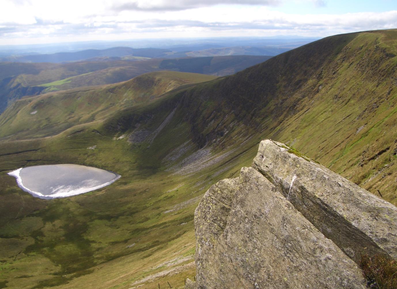
The mountain lies on main ridge of the Berwyn range which runs north–south. The eastern side of the ridge is characterised by steep drops and crags including Craig Berwyn north of the summit and Craig y Llyn to the south. Craig y Llyn forms the headwall of a cwm, and it is to this that the word cadair (chair in Welsh) presumably refers. Further north along the ridge is Cadair Bronwen, whilst to south the ridge continues to Moel Sych (Welsh pronunciation: �mɔil ˈsɨːx meaning "dry hill").
It is often reported that Moel Sych, along the ridge, is of equal height, but Cadair Berwyn's spot height
A spot height is an exact point on a map with an elevation recorded beside it that represents its height above a given datum.Whittow, John (1984). ''Dictionary of Physical Geography''. London: Penguin, 1984, p. 506. .
In the UK this is the Ordnan ...
on the Ordnance Survey maps, where the trig point stands, is not the true summit. Cadair Berwyn's summit, south of the trig point, is three metres taller than Moel Sych. This summit is listed as Cadair Berwyn New Top on the Nuttall list.
Several other summits in the area are listed as Hewitts or Nuttalls, including Foel Wen ( �vɔil ˈwɛn Welsh for white hill) and Mynydd Tarw ( �mɐnɨð ˈtæɾu bull mountain).
The summit lies on the border between Powys
Powys ( , ) is a Principal areas of Wales, county and Preserved counties of Wales, preserved county in Wales. It borders Gwynedd, Denbighshire, and Wrexham County Borough, Wrexham to the north; the English Ceremonial counties of England, ceremo ...
and Denbighshire
Denbighshire ( ; ) is a county in the north-east of Wales. It borders the Irish Sea to the north, Flintshire to the east, Wrexham to the southeast, Powys to the south, and Gwynedd and Conwy to the west. Rhyl is the largest town, and Ruthi ...
, and is the highest point in Denbighshire. The northern end of Craig Berwyn is the highest point in Wrexham County Borough
Wrexham County Borough () is a Principal areas of Wales, county borough, with city status in the United Kingdom, city status, in the North East Wales, north-east of Wales. It borders the English ceremonial counties of Cheshire and Shropshire to ...
.
History
There is astanding stone
A menhir (; from Brittonic languages: ''maen'' or ''men'', "stone" and ''hir'' or ''hîr'', "long"), standing stone, orthostat, or lith is a large upright rock (geology), stone, emplaced in the ground by humans, typically dating from the Eur ...
at SJ080337 near the summit between Cadair Berwyn and Tomle. It was re-erected in June 2008 by High Sports.
The Berwyn range also played its part in causing King Henry II of England
Henry II () was King of England
The monarchy of the United Kingdom, commonly referred to as the British monarchy, is the form of government used by the United Kingdom by which a hereditary monarch reigns as the head of state, with the ...
to turn back during his invasion of Gwynedd
Gwynedd () is a county in the north-west of Wales. It borders Anglesey across the Menai Strait to the north, Conwy, Denbighshire, and Powys to the east, Ceredigion over the Dyfi estuary to the south, and the Irish Sea to the west. The ci ...
in 1165. Rather than taking the usual route along the northern coastal plain, his army invaded from Oswestry and took a route over the Berwyns. The English invasion faced an alliance of Welsh princes led by King Owain Gwynedd
Owain ap Gruffudd ( – 23 or 28 November 1170) was King of Gwynedd, North Wales, from 1137 until his death in 1170, succeeding his father Gruffudd ap Cynan. He was called Owain the Great () and the first to be styled "Prince of Wales" and th ...
, but there was little fighting – endless days of heavy rain forced the English to retreat.
Alleged UFO crash
At 8.38 pm on 23 January 1974, an earthquake of magnitude 3.5 was felt over a wide area of north Wales and as far as Liverpool. Since earthquakes are uncommon in the UK, it was not generally recognized for what it was, and since a number of unusual lights in the sky had been observed the same evening, it was considered possible that an aircraft had crashed, or a meteorite had impacted. Further confusion was caused by lights seen on the Berwyn Mountains, which subsequently turned out to have belonged to poachers.Ecology
The area supports substantial populations of upland birds including raptors, such as thehen harrier
The hen harrier (''Circus cyaneus'') is a bird of prey. It breeds in Palearctic, Eurasia. The term "hen harrier" refers to its former habit of preying on free-ranging fowl.
It bird migration, migrates to more southerly areas in winter. Eurasian ...
(''Circus cyaneus''), merlin
The Multi-Element Radio Linked Interferometer Network (MERLIN) is an interferometer array of radio telescopes spread across England. The array is run from Jodrell Bank Observatory in Cheshire by the University of Manchester on behalf of UK Re ...
(''Falco columbarius''), and peregrine (''Falco peregrinus'') (about 14–18 breeding pairs of each species, 1%–2% of the total British population), and for this reason it is a Special Protection Area
A special protection area (SPA) is a designation under the European Union Directive on the Conservation of Wild Birds. Under the Directive, Member States of the European Union (EU) have a duty to safeguard the habitats of migratory birds and cer ...
classified in accordance with the European Union's Birds Directive
The Birds Directive (formally known as Council Directive 2009/147/EC on the conservation of wild birds) is the oldest piece of EU legislation on the environment and one of its cornerstones which was unanimously adopted in April 1979 as the Dir ...
. Much of the area is also designated a national nature reserve and a Site of Special Scientific Interest
A Site of Special Scientific Interest (SSSI) in Great Britain, or an Area of Special Scientific Interest (ASSI) in the Isle of Man and Northern Ireland, is a conservation designation denoting a protected area in the United Kingdom and Isle ...
and forms part of the Berwyn and South Clwyd Mountains Special Area of Conservation
A special area of conservation (SAC) is defined in the European Union's Habitats Directive (92/43/EEC), also known as the ''Directive on the Conservation of Natural Habitats and of Wild Fauna and Flora''. They are to protect the 220 habitats and ap ...
. Other wildlife include short-eared owl
The short-eared owl (''Asio flammeus'') is a widespread grassland species in the family Strigidae. Owls belonging to genus ''Asio'' are known as the eared owls, as they have tufts of feathers resembling mammalian ears. These "ear" tufts may or ...
, raven
A raven is any of several large-bodied passerine bird species in the genus '' Corvus''. These species do not form a single taxonomic group within the genus. There is no consistent distinction between crows and ravens; the two names are assigne ...
, buzzard
Buzzard is the common name of several species of birds of prey.
''Buteo'' species
* Archer's buzzard (''Buteo archeri'')
* Augur buzzard (''Buteo augur'')
* Broad-winged hawk (''Buteo platypterus'')
* Common buzzard (''Buteo buteo'')
* Easte ...
, polecat
Polecat is a common name for several mustelid species in the order Carnivora and subfamilies Ictonychinae and Mustelinae. Polecats do not form a single taxonomic rank (i.e. clade). The name is applied to several species with broad similarities t ...
and golden plover.
Etymology
The scholar T. Gwynn Jones suggested that a possible origin of the term "Berwyn" was "Bryn(iau) Gwyn (ap Nudd)", where the Middle Welsh word ''"bre"'' (hill) had mutated to ''Ber'' + ''Gwyn'',Gwyn ap Nudd
Gwyn ap Nudd (, sometimes found with the antiquated spelling Gwynn ap Nudd) is a Welsh mythological figure, the king of the '' Tylwyth Teg'' or " fair folk" and ruler of the Welsh Otherworld, Annwn, and whose name means “Gwyn, son of Nudd”. D ...
being the mythological King of the Tylwyth Teg
(Middle Welsh for "Fair Family"; ) is the most usual term in Wales for the mythological creatures corresponding to the fairy folk of Welsh and Irish folklore . Other names for them include ("Blessing of the Mothers"), and .
Origins
The ter ...
(Fair Folk, or fairies). A more likely etymology is ''"bar"'' (summit, crest) + ''"gwyn"'' (white),D. Geraint Lewis, ''Y Llyfr Enwau – Enwau'r Wlad: A check-list of Welsh Place Names'' (2007). with the ''"a"'' in ''"bar"'' showing i-affection as a result of the ''"y"'' in ''"gwyn"'', therefore changing from ''"a"'' to ''"e"''; the word also shows '' soft mutation'' of the letter ''"g"'' (which is deleted under soft mutation).
Peaks

References
{{coord, 52, 55, 16, N, 3, 25, 26, W, region:GB_source:kolossus-eswiki, display=title Landforms of Denbighshire Landforms of Wrexham County Borough Landforms of Powys Landforms of Gwynedd Mountain ranges of Wales National nature reserves in Wales Special Protection Areas in Wales Sites of Special Scientific Interest in Clwyd Sites of Special Scientific Interest in East Gwynedd Sites of Special Scientific Interest in Montgomery