Ambrose Channel on:
[Wikipedia]
[Google]
[Amazon]


 Ambrose Channel is the only shipping channel in and out of the
National Data Buoy Center
- Station ALSN6 - Ambrose Light, NY
New York Harbor Approaches
NOAA Chart 12326 online.
Sandy Hook Pilots
South Street Seaport Museum
- Current location of the Ambrose Lightship Port of New York and New Jersey Bodies of water of Queens, New York Bodies of water of Monmouth County, New Jersey Shipping channels {{MonmouthCountyNJ-geo-stub

Port of New York and New Jersey
The Port of New York and New Jersey is the port district of the New York metropolitan area, New York-Newark metropolitan area, encompassing the region within approximately a radius of the Statue of Liberty National Monument.
It includes the sy ...
. The channel is considered to be part of Lower New York Bay and is located several miles off the coasts of Sandy Hook, New Jersey, and Breezy Point, New York. Ambrose Channel terminates at Ambrose Anchorage, just south of the Verrazzano Narrows Bridge, the gateway to New York Harbor
New York Harbor is a bay that covers all of the Upper Bay. It is at the mouth of the Hudson River near the East River tidal estuary on the East Coast of the United States.
New York Harbor is generally synonymous with Upper New York Bay, ...
, where it becomes known as the Anchorage Channel. It is named for John Wolfe Ambrose, an engineer from New York.
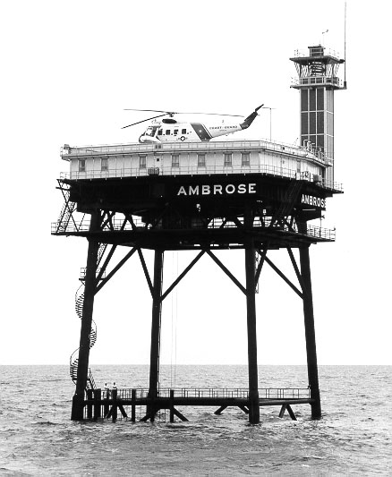
The entrance to the channel was marked by Ambrose Light which doubled as a staging area for pilot boat
A pilot boat is a type of boat used to transport maritime pilots between land and the inbound or outbound ships that they are piloting. Pilot boats were once sailing boats that had to be fast because the first pilot to reach the incoming ship ...
s, most notably the Sandy Hook Pilots. Prior to the construction of the light tower in 1967 the channel was marked by the Ambrose Lightship, one of a class of lightships
A lightvessel, or lightship, is a ship that acts as a lighthouse. It is used in waters that are too deep or otherwise unsuitable for lighthouse construction. Although some records exist of fire beacons being placed on ships in Roman times, the ...
operated and maintained by the United States Coast Guard
The United States Coast Guard (USCG) is the maritime security, search and rescue, and Admiralty law, law enforcement military branch, service branch of the armed forces of the United States. It is one of the country's eight Uniformed services ...
for the express purpose of marking main shipping channels for major ports. After being struck by small boats on a number of occasions, the light tower was redesigned and relocated in 1999, and finally decommissioned and removed in 2008.
Once inside the Narrows, Ambrose becomes the Anchorage Channel which splits into channels to marine terminals. Connecting channels are the Bay Ridge, the Red Hook, the Buttermilk
Buttermilk is a fermented dairy drink. Traditionally, it was the liquid left behind after churning butter out of cultured cream. As most modern butter in Western countries is not made with cultured cream but uncultured sweet cream, most mode ...
, the Claremont, the Port Jersey, the Kill Van Kull
__NOTOC__
The Kill Van Kull is a tidal strait between Staten Island, New York (state), New York, and Bayonne, New Jersey, Bayonne, New Jersey, in the United States. It is approximately long and wide and connects Newark Bay with Upper New York ...
, the Newark Bay
Newark Bay is a tidal bay at the confluence of the Passaic and Hackensack Rivers in northeastern New Jersey. It is home to the Port Newark-Elizabeth Marine Terminal, the largest container shipping facility in Port of New York and New Jerse ...
, the Port Newark
A port is a maritime facility comprising one or more wharves or loading areas, where ships load and discharge cargo and passengers. Although usually situated on a sea coast or estuary, ports can also be found far inland, such as Hamburg, Manche ...
, the Elizabeth, and the Arthur Kill
The Arthur Kill (sometimes referred to as the Staten Island Sound) is a tidal strait in the New York–New Jersey Harbor Estuary between Staten Island (also known as Richmond County), New York, and Union and Middlesex counties, New Jersey. It ...
. Anchorages are known as Stapleton, Bay Ridge and Gravesend
Gravesend is a town in northwest Kent, England, situated 21 miles (35 km) east-southeast of Charing Cross (central London) on the Bank (geography), south bank of the River Thames, opposite Tilbury in Essex. Located in the diocese of Roche ...
.
See also
* Ambrose Channel pilot cable * Hudson Canyon * New York BightReferences
Notes Further reading *National Data Buoy Center
- Station ALSN6 - Ambrose Light, NY
New York Harbor Approaches
NOAA Chart 12326 online.
External links
Sandy Hook Pilots
South Street Seaport Museum
- Current location of the Ambrose Lightship Port of New York and New Jersey Bodies of water of Queens, New York Bodies of water of Monmouth County, New Jersey Shipping channels {{MonmouthCountyNJ-geo-stub