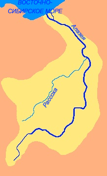
Alazeya on:
[Wikipedia]
[Google]
[Amazon]
The Alazeya (; ) is a river in the northeastern part of
in the
Yakutia
Sakha, officially the Republic of Sakha (Yakutia), is a republics of Russia, republic of Russia, and the largest federal subject of Russia by area. It is located in the Russian Far East, along the Arctic Ocean, with a population of one million ...
, Russia
Russia, or the Russian Federation, is a country spanning Eastern Europe and North Asia. It is the list of countries and dependencies by area, largest country in the world, and extends across Time in Russia, eleven time zones, sharing Borders ...
which flows into the Arctic between the basins of the larger Indigirka
The Indigirka (; ) is a river in the Sakha Republic in Russia between the Yana to the west and the Kolyma to the east. It is long. The area of its basin is .
History
The isolated village of Russkoye Ustye, located on the delta of the Indigi ...
to the west and the Kolyma
Kolyma (, ) or Kolyma Krai () is a historical region in the Russian Far East that includes the basin of Kolyma River and the northern shores of the Sea of Okhotsk, as well as the Kolyma Mountains (the watershed of the two). It is bounded to ...
to the east.
Mount Kisilyakh-Tas is a notable kigilyakh site on the right bank of the Alazeya River at .
Geography
The river is long. The area of its basin is . The Alazeya is formed at the confluence of the Nelkan and Kadylchan rivers in the slopes of the Alazeya Plateau. It crosses roughly northwards through the tundra meandering among the flat, marshy areas of the Kolyma Lowland, part of the greater East Siberian Lowland. Finally the Alazeya drains into the Kolyma Bay of theEast Siberian Sea
The East Siberian Sea (; ) is a marginal sea in the Arctic Ocean. It is located between the Arctic Cape to the north, the coast of Siberia to the south, the New Siberian Islands to the west and Cape Billings, close to Chukchi Peninsula, Chukotka, ...
, close to Logashkino
Logashkino () was a types of inhabited localities in Russia, settlement in Nizhnekolymsky Ulus of the Sakha Republic, Russia, which was abolished in 1998.Resolution #443 of September 29, 1998 ''On Exclusion of Inhabited Localities from the Recor ...
. The river freezes in late September through early October and stays icebound until late May through early June. There are more than 24,000 lakes in its basin.Google Earth
Google Earth is a web mapping, web and computer program created by Google that renders a 3D computer graphics, 3D representation of Earth based primarily on satellite imagery. The program maps the Earth by superimposition, superimposing satelli ...
Алазеяin the
Great Soviet Encyclopedia
The ''Great Soviet Encyclopedia'' (GSE; , ''BSE'') is one of the largest Russian-language encyclopedias, published in the Soviet Union from 1926 to 1990. After 2002, the encyclopedia's data was partially included into the later ''Great Russian Enc ...
.

Tributaries
The biggest tributaries of the Alazeya are the long Rassokha and long Buor-Yuryakh from the left, as well as the long Sloboda River and the long Buor-Yuryakh from the right.History
Dmitrii Zyryan was the first Russian to reach the Alazeya in 1641, but did not found a permanent settlement.See also
*List of rivers of Russia
Russia can be divided into a European and an Asian part. The dividing line is generally considered to be the Ural Mountains. The European part is drained into the Arctic Ocean, Baltic Sea, Black Sea, and Caspian Sea. The Asian part is drained i ...
References
Rivers of the Sakha Republic East Siberian Lowland {{FarEast-Russia-river-stub