|
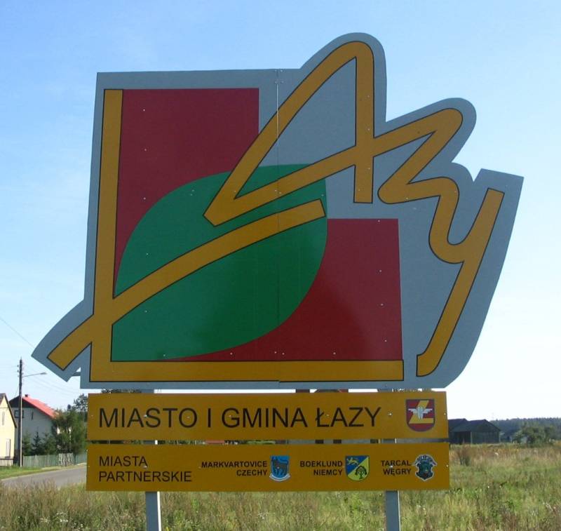
Łazy
┼üazy is a town in Zawiercie County, Silesian Voivodeship, Poland. Until 1947 the town was the seat of the Rokitno Szlacheckie municipality. In the years 1975ŌĆō1998 the town administratively belonged to the Katowice province. As of 2019, the town has 6,811 inhabitants. During World War II, German occupiers changed the name to ''Lazy'' then to ''Lasern'' without a legislative decree. ┼üazy belongs to the province of Lesser Poland, and since its foundation until the Partitions of Poland, it was part of Krakow Voivodeship. History In the Middle Ages, in the area of today's ┼üazy were five settlements: Grabowa, Niegowonice, Wiesiolka, Wysoka and Ciagowice. Another village, which today is located within boundaries of ┼üazy, Chruszczobrod, belonged to the Duchy of Siewierz, which was incorporated into the PolishŌĆōLithuanian Commonwealth in 1790. In the year 1386, King Wladyslaw Jagiello granted the villages of Niegowonice, Wiesiolka, Wysoka, Grabowa and Rokitno Szlacheckie ... [...More Info...] [...Related Items...] OR: [Wikipedia] [Google] [Baidu] |
Gmina Łazy
__NOTOC__ Gmina ┼üazy is an urban-rural gmina (administrative district) in Zawiercie County, Silesian Voivodeship, in southern Poland. Its seat is the town of ┼üazy, which lies approximately south of Zawiercie and north-east of the regional capital Katowice. The gmina covers an area of , and as of 2019 its total population is 15,923. The gmina contains part of the protected area called Eagle Nests Landscape Park. Villages Apart from the town of ┼üazy, Gmina ┼üazy contains the villages and settlements of K─ģdziel├│w, Ku┼║nica Mas┼éo┼äska, Rokitno Szlacheckie and Turza. Neighbouring gminas Gmina ┼üazy is bordered by the towns of D─ģbrowa G├│rnicza, Por─Öba and Zawiercie, and by the gminas of Klucze, Ogrodzieniec and Siewierz Siewierz is a town in southern Poland, in the B─Ödzin County in the Silesian Voivodeship, seat of Gmina Siewierz. History Siewierz was first mentioned in 1125, and was administered by the Castellan of Bytom. In 1177, Casimir II of Poland grant .. ... [...More Info...] [...Related Items...] OR: [Wikipedia] [Google] [Baidu] |
Zawiercie County
__NOTOC__ Zawiercie County ( pl, powiat zawiercia┼äski) is a unit of territorial administration and local government (powiat) in Silesian Voivodeship, southern Poland. It came into being on January 1, 1999, as a result of the Polish local government reforms passed in 1998. Its administrative seat and largest town is Zawiercie, which lies north-east of the regional capital Katowice. The county contains five other towns: Por─Öba, west of Zawiercie, ┼üazy, south of Zawiercie, Ogrodzieniec, south-east of Zawiercie, Szczekociny, north-east of Zawiercie, and Pilica, east of Zawiercie. The county covers an area of . As of 2019 its total population is 118,020. The most populated towns are Zawiercie with 49,334 inhabitants and Por─Öba with 8,525 inhabitants. Neighbouring counties Zawiercie County is bordered by Cz─Östochowa County to the north, W┼éoszczowa County to the north-east, J─Ödrzej├│w County and Miech├│w County to the east, Olkusz County and the city of D─ģbrowa G├│rnicza ... [...More Info...] [...Related Items...] OR: [Wikipedia] [Google] [Baidu] |
Silesian Voivodeship
Silesian Voivodeship, or Silesia Province ( pl, wojew├│dztwo ┼øl─ģskie ) is a voivodeship, or province, in southern Poland, centered on the historic region known as Upper Silesia ('), with Katowice serving as its capital. Despite the Silesian Voivodeship's name, most of the historic Silesia region lies outside the present Silesian Voivodeship ŌĆō divided among Lubusz, Lower Silesian, and Opole Voivodeships. The eastern half of Silesian Voivodeship (and, notably, Cz─Östochowa in the north) was historically part of Lesser Poland. The Voivodeship was created on 1 January 1999 out of the former Katowice, Cz─Östochowa and Bielsko-Bia┼éa Voivodeships, pursuant to the Polish local government reforms adopted in 1998. It is the most densely populated voivodeship in Poland. Within the area of 12,300 square kilometres, there are almost 5 million inhabitants. It is also the largest urbanised area in Central and Eastern Europe. In relation to economy, over 13% of Poland's gross d ... [...More Info...] [...Related Items...] OR: [Wikipedia] [Google] [Baidu] |
Kingdom Of Prussia
The Kingdom of Prussia (german: K├Čnigreich Preu├¤en, ) constituted the German state of Prussia between 1701 and 1918. Marriott, J. A. R., and Charles Grant Robertson. ''The Evolution of Prussia, the Making of an Empire''. Rev. ed. Oxford: Clarendon Press, 1946. It was the driving force behind the unification of Germany in 1866 and was the leading state of the German Empire until its dissolution in 1918. Although it took its name from the region called Prussia, it was based in the Margraviate of Brandenburg. Its capital was Berlin. The kings of Prussia were from the House of Hohenzollern. Brandenburg-Prussia, predecessor of the kingdom, became a military power under Frederick William, Elector of Brandenburg, known as "The Great Elector". As a kingdom, Prussia continued its rise to power, especially during the reign of Frederick II "the Great".Horn, D. B. "The Youth of Frederick the Great 1712ŌĆō30." In Frederick the Great and the Rise of Prussia, 9ŌĆō10. 3rd ed. Lon ... [...More Info...] [...Related Items...] OR: [Wikipedia] [Google] [Baidu] |

