|
The Brisons
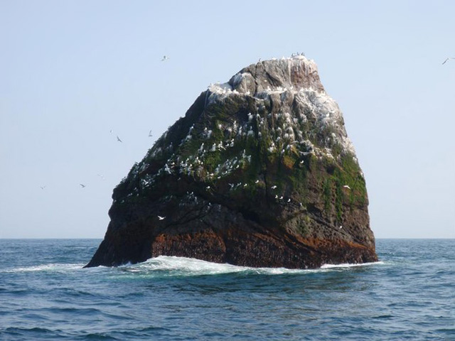
The Brisons (, meaning ''breaker island'') is a twin-peaked islet in the Celtic Sea situated 1 mile (1.6 km) offshore from Cape Cornwall in Cornwall, on the south-western coast of Great Britain. Geography The Brisons (the name is French: brisant, 'reef, breaker') are and high and are said to resemble General Charles de Gaulle lying on his back ("General de Gaulle in his bath"). The rocks are connected to Gribba Point (, meaning ''head of the reefs'') by the Guthen Gwidden reef (, meaning ''white hidden one''). The gap in the reef is called the Adgiwar Gap (, meaning ''green gap''). In 1878, an article in the Cornishman newspaper names the reef between the ″Brissons″ and the land as Bridges, and the reef had three gaps; the nearest known as Rose-an-pons. Wildlife and ecology In 2016 the rocks were visited by the West Cornwall Ringing Group where they heard at least two European storm petrel (''Hydrobates pelagicus'') calling; an indication of breeding on the only ... [...More Info...] [...Related Items...] OR: [Wikipedia] [Google] [Baidu] |
Islet
An islet ( ) is generally a small island. Definitions vary, and are not precise, but some suggest that an islet is a very small, often unnamed, island with little or no vegetation to support human habitation. It may be made of rock, sand and/or hard coral; may be permanent or tidal (i.e. surfaced reef or seamount); and may exist in the sea, lakes, rivers or any other sizeable bodies of water. Definition As suggested by its origin ''islette'', an Old French diminutive of "isle", use of the term implies small size, but little attention is given to drawing an upper limit on its applicability. The World Landforms website says, "An islet landform is generally considered to be a rock or small island that has little vegetation and cannot sustain human habitation", and further that size may vary from a few square feet to several square miles, with no specific rule pertaining to size. Other terms * Ait (/eɪt/, like eight) or eyot (/aɪ(ə)t, eɪt/), a small island. It is espe ... [...More Info...] [...Related Items...] OR: [Wikipedia] [Google] [Baidu] |
Common Murre
The common murre or common guillemot (''Uria aalge'') is a large auk. It has a Subarctic, circumpolar distribution, occurring in low-Arctic and boreal waters in the North Atlantic and North Pacific. It spends most of its time at sea, only coming to land to breed on rocky cliff shores or islands. Common murres are fast in direct flight but are not very agile. They are highly mobile underwater using their wings to 'fly' through the water column, where they typically dive to depths of . Depths of up to have been recorded. Common murres breed in Bird colony, colonies at high densities. Nesting pairs may be in bodily contact with their neighbours. They make no nest; their single egg is Avian incubation, incubated between the adult's feet on a bare rock ledge on a cliff face. Eggs hatch after ~30 days incubation. The chick is born Down feather, downy and can regulate its body temperature after 10 days. Some 20 days after hatching, the chick leaves its nesting ledge and heads for the s ... [...More Info...] [...Related Items...] OR: [Wikipedia] [Google] [Baidu] |
Uninhabited Islands Of Cornwall
The list of uninhabited regions includes a number of places around the globe. The list changes year over year as human beings migrate into formerly uninhabited regions, or migrate out of formerly inhabited regions. Definitions The exact definition of what makes a place "uninhabited" is not simple. Nomadic hunter-gather and pastoral societies live in extremely low population densities and range across large territories where they camp, rather than staying in any one place year-round. During the height of settler colonialism many European governments declared huge areas of the New World and Australia to be ''Terra nullius'' (land belonging to no one), but this was done to create a legal pretext to annex them to European empires; these lands were not, and are not uninhabited. While some communities are still nomadic, there are many remote and isolated communities in the less populated parts of the world that are separated from each other by hundreds or thousands kilometres ... [...More Info...] [...Related Items...] OR: [Wikipedia] [Google] [Baidu] |
Seabird Colonies
Seabirds (also known as marine birds) are birds that are adapted to life within the marine environment. While seabirds vary greatly in lifestyle, behaviour and physiology, they often exhibit striking convergent evolution, as the same environmental problems and feeding niches have resulted in similar adaptations. The first seabirds evolved in the Cretaceous period, while modern seabird families emerged in the Paleogene. Seabirds generally live longer, breed later and have fewer young than other birds, but they invest a great deal of time in their young. Most species nest in colonies, varying in size from a few dozen birds to millions. Many species are famous for undertaking long annual migrations, crossing the equator or circumnavigating the Earth in some cases. They feed both at the ocean's surface and below it, and even on each other. Seabirds can be highly pelagic, coastal, or in some cases spend a part of the year away from the sea entirely. Seabirds and humans have ... [...More Info...] [...Related Items...] OR: [Wikipedia] [Google] [Baidu] |
Reefs Of England
A reef is a ridge or shoal of rock, coral, or similar relatively stable material lying beneath the surface of a natural body of water. Many reefs result from natural, abiotic (non-living) processes such as deposition of sand or wave erosion planning down rock outcrops. However, reefs such as the coral reefs of tropical waters are formed by biotic (living) processes, dominated by corals and coralline algae. Artificial reefs, such as shipwrecks and other man-made underwater structures, may occur intentionally or as the result of an accident. These are sometimes designed to increase the physical complexity of featureless sand bottoms to attract a more diverse range of organisms. They provide shelter to various aquatic animals which help prevent extinction. Another reason reefs are put in place is for aquaculture, and fish farmers who are looking to improve their businesses sometimes invest in them. Reefs are often quite near to the surface, but not all definitions require this. ... [...More Info...] [...Related Items...] OR: [Wikipedia] [Google] [Baidu] |
Penwith
Penwith (; ) is an area of Cornwall, England, located on the peninsula of the same name. It is also the name of a former Non-metropolitan district, local government district, whose council was based in Penzance. The area is named after one of the ancient administrative hundreds of Cornwall which derives from two Cornish language, Cornish words, ''penn'' meaning 'headland' and ''wydh'' meaning 'at the end'. Natural England have designated the peninsula as national character area 156 and named it West Penwith. It is also known as the Land's End Peninsula. Geography The Penwith peninsula sits predominantly on granite bedrock that has led to the formation of a rugged coastline with many fine beaches. The contact between the granite and the adjoining sedimentary rock (mostly shales) is most clearly seen forming the cliffs at Land's End, the most westerly point in the district and this geology has resulted in the mining that has made Cornwall famous. Tin and copper have been min ... [...More Info...] [...Related Items...] OR: [Wikipedia] [Google] [Baidu] |
Landforms Of Cornwall
A landform is a land feature on the solid surface of the Earth or other planetary body. They may be natural or may be anthropogenic (caused or influenced by human activity). Landforms together make up a given terrain, and their arrangement in the landscape is known as topography. Landforms include hills, mountains, canyons, and valleys, as well as shoreline features such as bays, peninsulas, and seas, including submerged features such as mid-ocean ridges, volcanoes, and the great oceanic basins. Physical characteristics Landforms are categorized by characteristic physical attributes such as elevation, slope, orientation, structure stratification, rock exposure, and soil type. Gross physical features or landforms include intuitive elements such as berms, cliffs, hills, mounds, peninsulas, ridges, rivers, valleys, volcanoes, and numerous other structural and size-scaled (e.g. ponds vs. lakes, hills vs. mountains) elements including various kinds of inland and oceanic waterbodi ... [...More Info...] [...Related Items...] OR: [Wikipedia] [Google] [Baidu] |
The Brisons
The Brisons (, meaning ''breaker island'') is a twin-peaked islet in the Celtic Sea situated 1 mile (1.6 km) offshore from Cape Cornwall in Cornwall, on the south-western coast of Great Britain. Geography The Brisons (the name is French: brisant, 'reef, breaker') are and high and are said to resemble General Charles de Gaulle lying on his back ("General de Gaulle in his bath"). The rocks are connected to Gribba Point (, meaning ''head of the reefs'') by the Guthen Gwidden reef (, meaning ''white hidden one''). The gap in the reef is called the Adgiwar Gap (, meaning ''green gap''). In 1878, an article in the Cornishman newspaper names the reef between the ″Brissons″ and the land as Bridges, and the reef had three gaps; the nearest known as Rose-an-pons. Wildlife and ecology In 2016 the rocks were visited by the West Cornwall Ringing Group where they heard at least two European storm petrel (''Hydrobates pelagicus'') calling; an indication of breeding on the only ... [...More Info...] [...Related Items...] OR: [Wikipedia] [Google] [Baidu] |
Sennen Cove
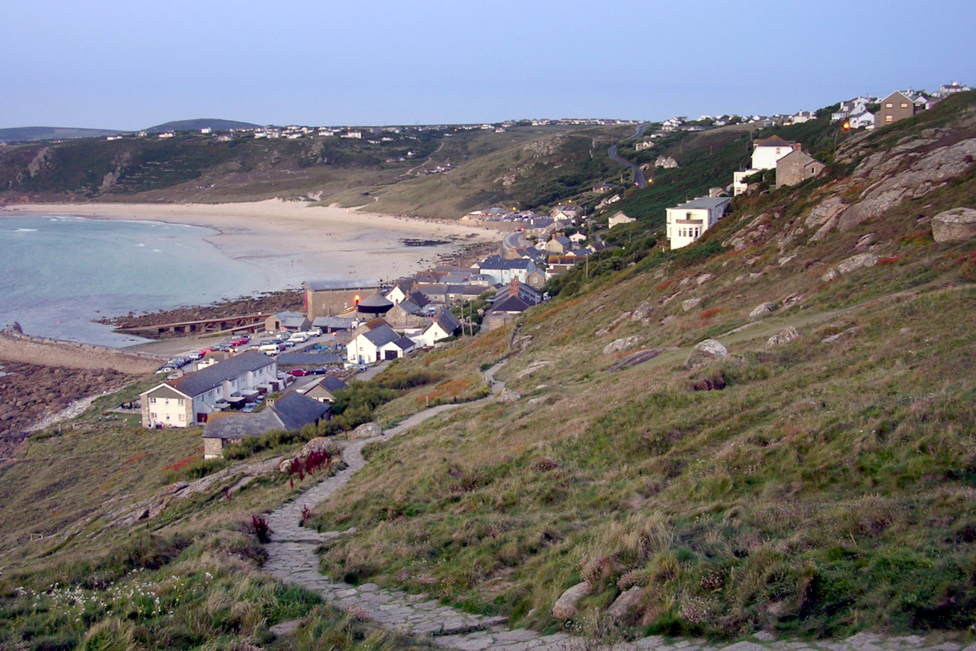
Sennen Cove () () is a small coastal village in the parish of Sennen in Cornwall, England, United Kingdom. According to the Penwith District Council, the population of this settlement was estimated at 180 persons in 2000. The South West Coast Path passes through Sennen Cove. Geography The village of Sennen Cove overlooks the southern end of Whitesand Bay. There is not a cove in the usual geological sense. The village (as distinct from Sennen, Sennen Churchtown), is on a spur road which joins the A30 road, A30 trunk road about two miles (3 km) from Land's End. Thus it is the first village from Land's End along the north coast. The road descends gently for about 300 yards and then steeply for another 300 yards to the village which lies above the beach. The beach extends further north along Whitesand Bay. There are a few dozen houses built primarily of granite and some of concrete, arranged mainly in Terraced house, terraces, typical of many of the villages in Cornwall. Seve ... [...More Info...] [...Related Items...] OR: [Wikipedia] [Google] [Baidu] |
Sennen Cove Lifeboat Station
Sennen Cove Lifeboat Station is the base for Royal National Lifeboat Institution (RNLI) search and rescue operations for the sea around Land's End, Cornwall in the United Kingdom. The first lifeboat was stationed at Sennen Cove in 1853. Since 2009 it has operated a all-weather boat (ALB) and a inshore lifeboat (ILB). History Sennen Cove is situated just to the north of Land's End, the most westerly point in mainland England. Following the loss of the ''New Commercial'' on the Brisons in January 1851, the RNLI built a boathouse at the top of the beach in 1853 and extended it in 1864 when a larger lifeboat was sent to the station. In 1876 a new boathouse was built on the landward side of the road, but in 1896 it was replaced by a new one on the site of the original building. A motor lifeboat was sent to the station in 1922. In preparation for this, the boathouse was given a new slipway in 1919 and a turntable was provided inside so that the lifeboat could be hauled up the slip ... [...More Info...] [...Related Items...] OR: [Wikipedia] [Google] [Baidu] |
RNLI
The Royal National Lifeboat Institution (RNLI) is the largest of the lifeboat services operating around the coasts of the United Kingdom, Ireland, the Channel Islands, and the Isle of Man, as well as on some inland waterways. Founded in 1824 as the National Institution for the Preservation of Life from Shipwreck, it soon afterwards became the Royal National Institution for the Preservation of Life from Shipwreck because of the patronage of King George IV. Royal patronage has continued up to the present day with King Charles III. The organisation changed its name to the Royal National Lifeboat Institution on 5 October 1854 and was granted a royal charter in 1860. The RNLI is a charity based in Poole, Dorset. It is principally funded by legacies (65%) and donations (30%). Most of its lifeboat crews are unpaid volunteers. They operate more than 400 lifeboats from 238 stations. Paid lifeguards provide services at nearly 250 beaches. The RNLI also provides free safety advice to ... [...More Info...] [...Related Items...] OR: [Wikipedia] [Google] [Baidu] |


