|
Submarine Channel
Abyssal channels (also, deep-sea channels, underwater channels) are channels in Earth's sea floor. They are formed by fast-flowing floods of turbid water caused by avalanches near the channel's head, with the sediment carried by the water causing a build-up of the surrounding abyssal plains. Submarine channels and the turbidite systems which form them are responsible for the accumulation of most sandstone deposits found on continental slopes and have proven to be one of the most common types of hydrocarbon reservoirs found in these regions. Submarine channels and their flanking levees are commonly referred to as ''channel levee systems''. They are significant geomorphological features that may run for thousands of kilometres across the ocean floor. Often, they coalesce and overlap to form channel levee complexes which are the building blocks of many major submarine fans. This makes them one of several geological processes responsible for the transport of coarse-grained sedimen ... [...More Info...] [...Related Items...] OR: [Wikipedia] [Google] [Baidu] |
Channel (geography)
In physical geography and hydrology, a channel is a landform on which a relatively narrow body of water is situated, such as a river, river delta or strait. While ''channel'' typically refers to a natural formation, the cognate term ''canal'' denotes a similar artificial structure. Channels are important for the functionality of ports and other bodies of water used for Navigability, navigability for shipping. Naturally, channels will change their depth and capacity due to erosion and Deposition (geology), deposition processes. Humans maintain navigable channels by dredging and other engineering processes. By extension, the term also applies to fluids other than water, e.g., lava channels. The term is also traditionally used to describe the Venusian channels, waterless surface features on Venus. Formation Channel initiation refers to the site on a mountain slope where water begins to flow between identifiable banks.Bierman, R. B, David R. Montgomery (2014). Key Concepts in Geom ... [...More Info...] [...Related Items...] OR: [Wikipedia] [Google] [Baidu] |
Canyon
A canyon (; archaic British English spelling: ''cañon''), gorge or chasm, is a deep cleft between escarpments or cliffs resulting from weathering and the erosive activity of a river over geologic time scales. Rivers have a natural tendency to cut through underlying surfaces, eventually wearing away rock layers as sediments are removed downstream. A river bed will gradually reach a baseline elevation, which is the same elevation as the body of water into which the river drains. The processes of weathering and erosion will form canyons when the river's headwaters and estuary are at significantly different elevations, particularly through regions where softer rock layers are intermingled with harder layers more resistant to weathering. A canyon may also refer to a rift between two mountain peaks, such as those in ranges including the Rocky Mountains, the Alps, the Himalayas or the Andes. Usually, a river or stream carves out such splits between mountains. Examples of mountain- ... [...More Info...] [...Related Items...] OR: [Wikipedia] [Google] [Baidu] |
Underwater Wave
A seiche ( ) is a standing wave in an enclosed or partially enclosed body of water. Seiches and seiche-related phenomena have been observed on lakes, reservoirs, swimming pools, bays, harbors, caves, and seas. The key requirement for formation of a seiche is that the body of water be at least partially bounded, allowing the formation of the standing wave. The term was promoted in 1890 by the Swiss hydrologist François-Alphonse Forel, who was the first to make scientific observations of the effect in Lake Geneva. The word had apparently long been used in the region to describe oscillations in alpine lakes. According to Wilson (1972), this Swiss French dialect word comes from the Latin word meaning "dry", i.e., as the water recedes, the beach dries. The French word or (dry) descends from the Latin. Seiches in harbours can be caused by ''long-period'' or '' infragravity waves'', which are due to subharmonic nonlinear wave interaction with the wind waves, having periods longer th ... [...More Info...] [...Related Items...] OR: [Wikipedia] [Google] [Baidu] |
Diapir
A diapir (; , ) is a type of intrusion in which a more mobile and ductilely deformable material is forced into brittle overlying rocks. Depending on the tectonic environment, diapirs can range from idealized mushroom-shaped Rayleigh–Taylor instability structures in regions with low tectonic stress such as in the Gulf of Mexico to narrow dikes of material that move along tectonically induced fractures in surrounding rock. The term was introduced by Romanian geologist Ludovic Mrazek, who was the first to understand the principle of salt tectonics and plasticity. The term ''diapir'' may be applied to '' igneous intrusions'', but it is more commonly applied to non-igneous, relatively cold materials, such as salt domes and mud diapirs. If a salt diapir reaches the surface, it can flow because salt becomes ductile with a small amount of moisture, forming a salt glacier. Occurrence Differential loading causes salt deposits covered by overburden (sediment) to rise upward tow ... [...More Info...] [...Related Items...] OR: [Wikipedia] [Google] [Baidu] |
Turbidite Channel
A turbidity current is most typically an underwater current of usually rapidly moving, sediment-laden water moving down a slope; although current research (2018) indicates that water-saturated sediment may be the primary actor in the process. Turbidity currents can also occur in other fluids besides water. Researchers from the Monterey Bay Aquarium Research Institute found that a layer of water-saturated sediment moved rapidly over the seafloor and mobilized the upper few meters of the preexisting seafloor. Plumes of sediment-laden water were observed during turbidity current events but they believe that these were secondary to the pulse of the seafloor sediment moving during the events. The belief of the researchers is that the water flow is the tail-end of the process that starts at the seafloor. In the most typical case of oceanic turbidity currents, sediment laden waters situated over sloping ground will flow down-hill because they have a higher density than the adjacen ... [...More Info...] [...Related Items...] OR: [Wikipedia] [Google] [Baidu] |
Froude Number
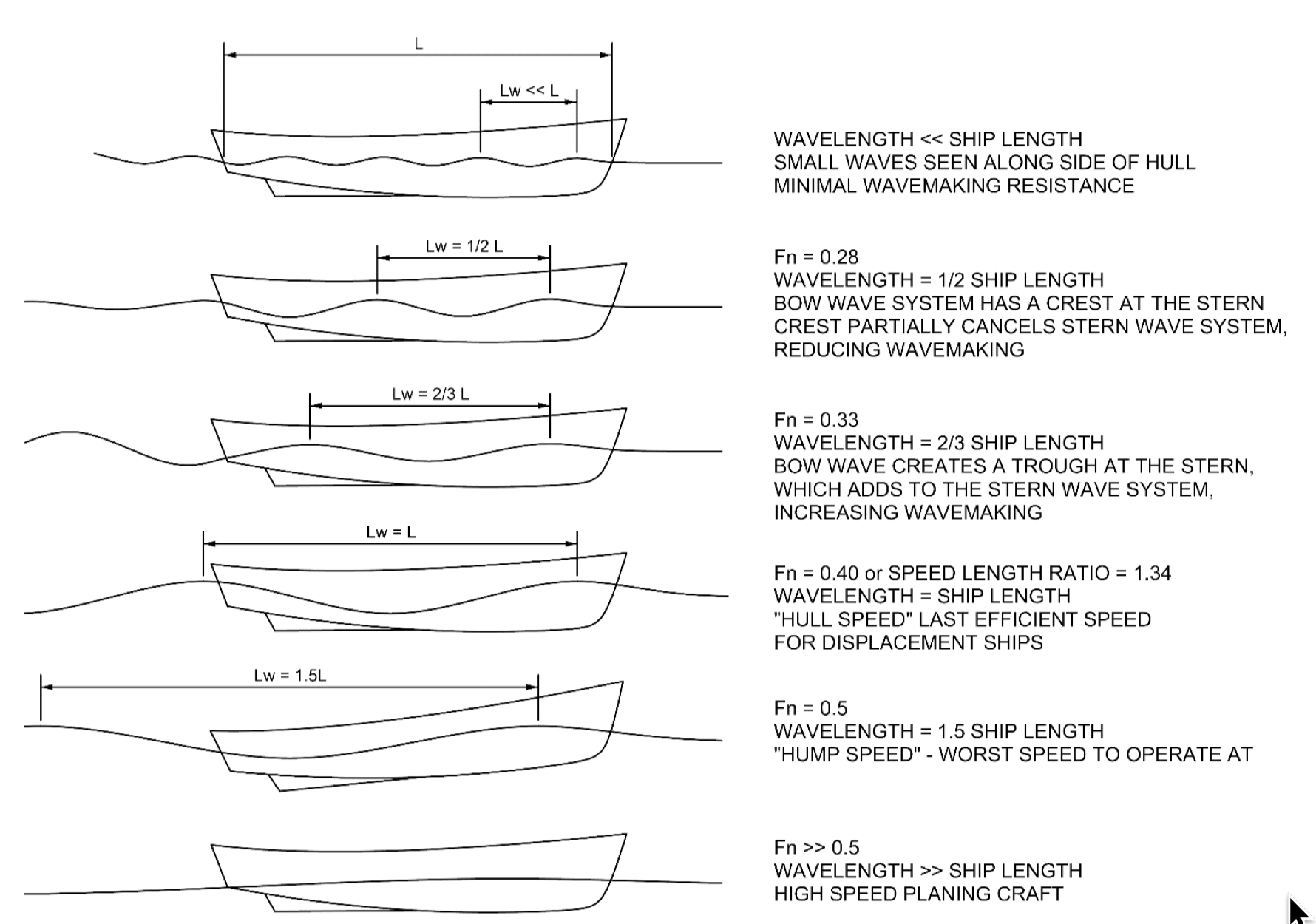
In continuum mechanics, the Froude number (, after William Froude, ) is a dimensionless number defined as the ratio of the flow inertia to the external force field (the latter in many applications simply due to gravity). The Froude number is based on the speed–length ratio which he defined as: \mathrm = \frac where is the local flow velocity (in m/s), is the local gravity field (in m/s2), and is a characteristic length (in m). The Froude number has some analogy with the Mach number. In theoretical fluid dynamics the Froude number is not frequently considered since usually the equations are considered in the high Froude limit of negligible external field, leading to homogeneous equations that preserve the mathematical aspects. For example, homogeneous Euler equations are conservation equations. However, in naval architecture the Froude number is a significant figure used to determine the resistance of a partially submerged object moving through water. Origins In open c ... [...More Info...] [...Related Items...] OR: [Wikipedia] [Google] [Baidu] |
Aggradation
Aggradation (or alluviation) is the term used in geology for the increase in land elevation, typically in a river system, due to the deposition of sediment. Aggradation occurs in areas in which the supply of sediment is greater than the amount of material that the system is able to transport. The mass balance between sediment being transported and sediment in the bed is described by the Exner equation. Typical aggradational environments include lowland alluvial rivers, river deltas, and alluvial fans. Aggradational environments are often undergoing slow subsidence which balances the increase in land surface elevation due to aggradation. After millions of years, an aggradational environment will become a sedimentary basin, which contains the deposited sediment, including paleochannels and ancient floodplains. Aggradation can be caused by changes in climate, land use, and geologic activity, such as volcanic eruption, earthquake An earthquakealso called a quake, tr ... [...More Info...] [...Related Items...] OR: [Wikipedia] [Google] [Baidu] |
Accretion (geology)
In geology, accretion is a process by which material is added to a tectonic plate at a subduction zone, frequently on the edge of existing continental landmasses. The added material may be sediment, volcanic arcs, seamounts, oceanic crust or other igneous features. Description Accretion involves the addition of material to a tectonic plate via subduction, the process by which one plate is forced under the other when two plates collide. The plate which is being forced down, the subducted plate, is pushed against the upper, over-riding plate. Sediment on the ocean floor of the subducting plate is often scraped off as the plate descends. This accumulated material is called an accretionary wedge (or accretionary prism), which is pushed against and attaches to the upper plate. In addition to accumulated ocean sediments, volcanic island arcs or seamounts present on the subducting plate may be amalgamated onto existing continental crust on the upper plate, increasing the contine ... [...More Info...] [...Related Items...] OR: [Wikipedia] [Google] [Baidu] |
Cross Section (geometry)
In geometry and science, a cross section is the non-empty intersection (set theory), intersection of a solid body in three-dimensional space with a Plane (geometry), plane, or the analog in higher-dimensional spaces. Cutting an object into slices creates many parallel cross-sections. The boundary of a cross-section in three-dimensional space that is parallel to two of the Cartesian coordinate system, axes, that is, parallel to the plane determined by these axes, is sometimes referred to as a contour line; for example, if a plane cuts through mountains of a raised-relief map parallel to the ground, the result is a contour line in two-dimensional space showing points on the surface of the mountains of equal elevation. In technical drawing a cross-section, being a Planar projection, projection of an object onto a plane that intersects it, is a common tool used to depict the internal arrangement of a 3-dimensional object in two dimensions. It is traditionally crosshatched with th ... [...More Info...] [...Related Items...] OR: [Wikipedia] [Google] [Baidu] |
Topographic
Topography is the study of the forms and features of land surfaces. The topography of an area may refer to the landforms and features themselves, or a description or depiction in maps. Topography is a field of geoscience and planetary science and is concerned with local detail in general, including not only relief, but also natural, artificial, and cultural features such as roads, land boundaries, and buildings. In the United States, topography often means specifically relief, even though the USGS topographic maps record not just elevation contours, but also roads, populated places, structures, land boundaries, and so on. Topography in a narrow sense involves the recording of relief or terrain, the three-dimensional quality of the surface, and the identification of specific landforms; this is also known as geomorphometry. In modern usage, this involves generation of elevation data in digital form ( DEM). It is often considered to include the graphic representation of the lan ... [...More Info...] [...Related Items...] OR: [Wikipedia] [Google] [Baidu] |
Sinuosity
Sinuosity, sinuosity index, or sinuosity coefficient of a continuously differentiable curve having at least one inflection point is the ratio of the curvilinear length (along the curve) and the Euclidean distance ( straight line) between the end points of the curve. This dimensionless quantity can also be rephrased as the "actual path length" divided by the "shortest path length" of a curve. The value ranges from 1 (case of straight line) to infinity (case of a closed loop, where the shortest path length is zero for an infinitely-long actual path). Interpretation The curve must be continuous (no jump) between the two ends. The sinuosity value is really significant when the line is continuously differentiable (no angular point). The distance between both ends can also be evaluated by a plurality of segments according to a broken line passing through the successive inflection points (sinuosity of order 2). The calculation of the sinuosity is valid in a 3-dimensional space (e. ... [...More Info...] [...Related Items...] OR: [Wikipedia] [Google] [Baidu] |
Fluvial
A river is a natural stream of fresh water that flows on land or inside caves towards another body of water at a lower elevation, such as an ocean, lake, or another river. A river may run dry before reaching the end of its course if it runs out of water, or only flow during certain seasons. Rivers are regulated by the water cycle, the processes by which water moves around the Earth. Water first enters rivers through precipitation, whether from rainfall, the runoff of water down a slope, the melting of glaciers or snow, or seepage from aquifers beneath the surface of the Earth. Rivers flow in channeled watercourses and merge in confluences to form drainage basins, or catchments, areas where surface water eventually flows to a common outlet. Rivers have a great effect on the landscape around them. They may regularly overflow their banks and flood the surrounding area, spreading nutrients to the surrounding area. Sediment or alluvium carried by rivers shapes the landscape a ... [...More Info...] [...Related Items...] OR: [Wikipedia] [Google] [Baidu] |


