|
Red-throated Piping Guan
The red-throated piping guan (''Pipile cujubi'') is a species of bird in the chachalaca, guan, and curassow family Cracidae. It is found in Bolivia and Brazil. Taxonomy and systematics The taxonomies of the International Ornithological Committee (IOC), ''The Clements Checklist of Birds of the World'', and ''Handbook of the Birds of the World'' treat the red-throated piping guan as one of four species in genus Pipile.Clements, J. F., T. S. Schulenberg, M. J. Iliff, S. M. Billerman, T. A. Fredericks, J. A. Gerbracht, D. Lepage, B. L. Sullivan, and C. L. Wood. 2021. The eBird/Clements checklist of Birds of the World: v2021. Downloaded from https://www.birds.cornell.edu/clementschecklist/download/ Retrieved August 25, 2021HBW and BirdLife International (2020) ''Handbook of the Birds of the World and BirdLife International digital checklist of the birds of the world'' Version 5. Available at: http://datazone.birdlife.org/userfiles/file/Species/Taxonomy/HBW-BirdLife_Checklist_v5_Dec ... [...More Info...] [...Related Items...] OR: [Wikipedia] [Google] [Baidu] |
Mato Grosso
Mato Grosso ( – ) is one of the states of Brazil, the List of Brazilian states by area, third largest by area, located in the Central-West Region, Brazil, Central-West region. The state has 1.66% of the Brazilian population and is responsible for 1.9% of the Brazilian GDP. Neighboring states (from west clockwise) are: Rondônia, Amazonas State, Brazil, Amazonas, Pará, Tocantins, Goiás and Mato Grosso do Sul. It is divided into 142 municipalities and covers an area of 903,357 square kilometers, consequently the state is roughly 82.2% of the size of its southwest neighbor, the nation of Bolivia. A state with a flat landscape that alternates between vast ''chapadas'' and plain areas, Mato Grosso contains three main ecosystems: the Cerrado, the Pantanal and the Amazon rainforest. The Chapada dos Guimarães National Park, with its caves, grottoes, tracks, and waterfalls, is one of its tourist attractions. The extreme northwest of the state has a small part of the Amazonian fores ... [...More Info...] [...Related Items...] OR: [Wikipedia] [Google] [Baidu] |
Gular Skin
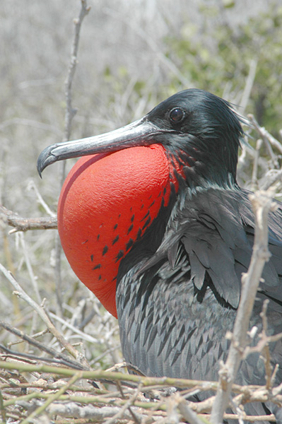
Gular skin (throat skin), in ornithology, is an area of featherless skin on birds that joins the lower mandible of the beak (or ''bill'') to the bird's neck. Other vertebrate taxa may have a comparable anatomical structure that is referred to as either a gular sac, throat sac, vocal sac or gular fold. In birds Gular skin can be very prominent, for example in members of the order Suliformes (gannets, frigatebirds, and cormorants) as well as in pelicans (which likely share a common ancestor). In many species, the gular skin forms a flap, or gular pouch, which is generally used to store fish and other prey while hunting. In cormorants, the gular skin is often brightly coloured, contrasting with the otherwise plain black or black-and-white appearance of the bird. This serves a function in social signalling, since it becomes more pronounced in breeding adults. In frigatebirds, the gular skin (or gular sac or throat sac) is used dramatically. During courtship display, the male for ... [...More Info...] [...Related Items...] OR: [Wikipedia] [Google] [Baidu] |
Birds Described In 1858
Birds are a group of warm-blooded vertebrates constituting the class Aves (), characterised by feathers, toothless beaked jaws, the laying of hard-shelled eggs, a high metabolic rate, a four-chambered heart, and a strong yet lightweight skeleton. Birds live worldwide and range in size from the bee hummingbird to the common ostrich. There are over 11,000 living species and they are split into 44 orders. More than half are passerine or "perching" birds. Birds have wings whose development varies according to species; the only known groups without wings are the extinct moa and elephant birds. Wings, which are modified forelimbs, gave birds the ability to fly, although further evolution has led to the loss of flight in some birds, including ratites, penguins, and diverse endemic island species. The digestive and respiratory systems of birds are also uniquely adapted for flight. Some bird species of aquatic environments, particularly seabirds and some waterbirds, have furthe ... [...More Info...] [...Related Items...] OR: [Wikipedia] [Google] [Baidu] |
IUCN
The International Union for Conservation of Nature (IUCN) is an international organization working in the field of nature conservation and sustainable use of natural resources. Founded in 1948, IUCN has become the global authority on the status of the natural world and the measures needed to safeguard it. It is involved in data gathering and Data analysis, analysis, research, field projects, advocacy, and education. IUCN's mission is to "influence, encourage and assist societies throughout the world to conserve nature and to ensure that any use of natural resources is equitable and ecologically sustainable". Over the past decades, IUCN has widened its focus beyond conservation ecology and now incorporates issues related to sustainable development in its projects. IUCN does not itself aim to mobilize the public in support of nature conservation. It tries to influence the actions of governments, business and other stakeholders by providing information and advice and through buildin ... [...More Info...] [...Related Items...] OR: [Wikipedia] [Google] [Baidu] |
Phenology
Phenology is the study of periodic events in biological life cycles and how these are influenced by seasonal and interannual variations in climate, as well as habitat factors (such as elevation). Examples include the date of emergence of leaves and flowers, the first flight of butterflies, the first appearance of migratory birds, the date of leaf colouring and fall in deciduous trees, the dates of egg-laying of birds and amphibia, or the timing of the developmental cycles of temperate-zone honey bee colonies. In the scientific literature on ecology, the term is used more generally to indicate the time frame for any seasonal biological phenomena, including the dates of last appearance (e.g., the seasonal phenology of a species may be from April through September). Because many such phenomena are very sensitive to small variations in climate, especially to temperature, phenological records can be a useful proxy for temperature in historical climatology, especially in the ... [...More Info...] [...Related Items...] OR: [Wikipedia] [Google] [Baidu] |
Santa Cruz Department (Bolivia)
Santa Cruz () is the largest of the Departments of Bolivia, nine constituent departments of Bolivia, occupying about one-third (33.74%) of the country's territory. With an area of , it is slightly smaller than Japan or the United States, US state of Montana. It is located in the eastern part of the country, sharing borders in the north and east with Brazil and with Paraguay in the south. In the 2024 census, it reported a population of 3,115,386 , making it the most populated department. The Capital (political), capital is the city of Santa Cruz de la Sierra. The department is one of the wealthiest departments in Bolivia, with huge reserves of natural gas. Besides, it has experienced the highest increase of economic growth during the last 50 years in Bolivia and South America. Government and administration According to the current Constitution of Bolivia, Constitution, the highest authority in the department lies with the governor. The former figure of prefect was appointed by ... [...More Info...] [...Related Items...] OR: [Wikipedia] [Google] [Baidu] |
Rondônia
Rondônia () is one of the 26 states of Brazil, located in the northern subdivision of the country (central-western part). It is bordered by Acre (state), Acre in the west, Amazonas, Brazil, Amazonas in the north, Mato Grosso in the east, and Bolivia in the south. Rondônia has a population of 1,815,000 as of 2021. It is the fifth least populated state. Its capital and largest city is Porto Velho, bathed by the Madeira River. The state was named after Cândido Rondon, who explored the north of the country during the 1910s. The state, which is home to c. 0.7% of the Brazilian population, is responsible for c. 0.3% of the Brazilian GDP. The state has 52 municipalities and occupies an area of 237,590.547 Square kilometre, km2, equivalent to the territory of Romania and almost five times larger than Croatia. In addition to this, there are other important cities such as Ariquemes, Cacoal, Guajará-Mirim, Ji-Paraná, Rolim de Moura and Vilhena. Geography Rondonia used to be home to ... [...More Info...] [...Related Items...] OR: [Wikipedia] [Google] [Baidu] |
Amazonas (Brazilian State)
Amazonas () is a federative units of Brazil, state of Brazil, located in the North Region, Brazil, North Region in the north-western corner of the country. It is the Federative units of Brazil#List, largest Brazilian state by area and the list of the largest country subdivisions by area, ninth-largest country subdivision in the world with an area of 1,570,745.7 square kilometers. It is the largest country subdivision in South America, being greater than the areas of Chile, Paraguay, and Uruguay combined. Neighbouring states are (from the north clockwise) Roraima, Pará, Mato Grosso, Rondônia, and Acre (state), Acre. It also borders the nations of Peru, Colombia and Venezuela. This includes the departments of Colombia, Departments of Amazonas (Colombian department), Amazonas, Vaupés Department, Vaupés and Guainía Department, Guainía in Colombia, as well as the Amazonas State, Venezuela, Amazonas state in Venezuela, and the Loreto Region in Peru. Amazonas is named after the A ... [...More Info...] [...Related Items...] OR: [Wikipedia] [Google] [Baidu] |
Goiás
Goiás () is a Brazilian States of Brazil, state located in the Central-West Region, Brazil, Central-West region. Goiás borders the Federal District (Brazil), Federal District and the states of (from north clockwise) Tocantins, Bahia, Minas Gerais, Mato Grosso do Sul and Mato Grosso. The state capital is Goiânia. With 7.2 million inhabitants, Goiás is the most populous state in the Central-West region and the List of Brazilian states by population, 11th most populous in the country. It has the List of Brazilian federative units by gross regional product, ninth largest economy among Brazilian federative units. In Brazil's geoeconomic division, Goiás belongs to the Centro-Sul (Center-South), being the northernmost state of the southern portion of Brazil. The state has 3.3% of the Brazilian population and is responsible for 2.7% of the Brazilian GDP. The history of Goiás dates back to the beginning of the 18th century, with the arrival of pioneers from São Paulo. The Rio Verm ... [...More Info...] [...Related Items...] OR: [Wikipedia] [Google] [Baidu] |
Pará
Pará () is a Federative units of Brazil, state of Brazil, located in northern Brazil and traversed by the lower Amazon River. It borders the Brazilian states of Amapá, Maranhão, Tocantins (state), Tocantins, Mato Grosso, Amazonas (Brazilian state), Amazonas and Roraima. To the northwest are the borders of Guyana and Suriname, to the northeast of Pará is the Atlantic Ocean. The capital and largest city is Belém, which is located at the Marajó bay, near the estuary of the Amazon river. The state, which is home to 4.1% of the Brazilian population, is responsible for just 2.2% of the Brazilian GDP. Pará is the most populous state of the North Region, Brazil, North Region, with a population of over 8.6 million, being the ninth-most populous state in Brazil. It is the second-largest state of Brazil in area, at , second only to Amazonas (Brazilian state), Amazonas upriver. Its most famous icons are the Amazon River and the Amazon rainforest. Pará produces Natural rubber, rubber ( ... [...More Info...] [...Related Items...] OR: [Wikipedia] [Google] [Baidu] |
Madeira River
The Madeira River ( ) is a major waterway in South America. It is estimated to be in length, while the Madeira-Mamoré is estimated near or in length depending on the measuring party and their methods. The Madeira is the biggest tributary of the Amazon, accounting for about 15% of the water in the basin. A map from Emanuel Bowen in 1747, held by the David Rumsey Map Collection, refers to the Madeira by the pre-colonial, indigenous name Cuyari. The River of Cuyari, called by the Portuguese Madeira or the Wood River, is formed by two great rivers, which join near its mouth. It was by this River, that the Nation of Topinambes passed into the River Amazon. Climate The mean inter-annual precipitations on the great basins vary from , the entire upper Madeira basin receiving . The greatest extremes of rainfall are between . Even just below the confluence that forms it, the Madeira is one of the largest rivers by discharge of the world, with a mean inter-annual discharge of , i.e ... [...More Info...] [...Related Items...] OR: [Wikipedia] [Google] [Baidu] |


