|
Provinces Of Ireland
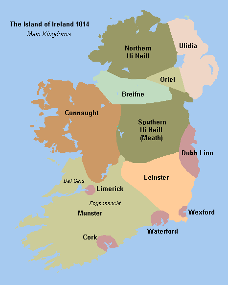
There are four provinces of Ireland: Connacht, Leinster, Munster and Ulster. The Irish language, Irish word for this territorial division, , meaning "fifth part", suggests that there were once five, and at times Kingdom of Meath, Meath has been considered to be the fifth province. In the medieval period, however, there were often more than five. The number of provinces and their delimitation fluctuated until 1610, when they were permanently set by the English administration of James VI and I, James I. The provinces of Ireland no longer serve administrative or political purposes but function as historical and cultural entities. Etymology In modern Irish language, Irish, the word for province is (pl. ). The modern Irish term derives from the Old Irish (pl. ) which literally meant "a fifth". This term appears in 8th-century law texts such as and in the legendary tales of the Ulster Cycle where it refers to the five kingdoms of the "Pentarchy". MacNeill enumerates the five earl ... [...More Info...] [...Related Items...] OR: [Wikipedia] [Google] [Baidu] |
Connacht
Connacht or Connaught ( ; or ), is the smallest of the four provinces of Ireland, situated in the west of Ireland. Until the ninth century it consisted of several independent major Gaelic kingdoms (Uí Fiachrach, Uí Briúin, Uí Maine, Conmhaícne, and Delbhna). Between the reigns of Conchobar mac Taidg Mór (died 882) and his descendant, Aedh mac Ruaidri Ó Conchobair (reigned 1228–33), it became a kingdom under the rule of the Uí Briúin Aí dynasty, whose ruling sept adopted the surname Ua Conchobair. At its greatest extent, it incorporated the often independent Kingdom of Breifne, as well as vassalage from the lordships of western Mide and west Leinster. Two of its greatest kings, Tairrdelbach Ua Conchobair (1088–1156) and his son Ruaidri Ua Conchobair (c. 1115–1198) greatly expanded the kingdom's dominance, so much so that both became High King of Ireland. The Kingdom of Connacht collapsed in the 1230s because of civil war within the royal dynasty, which enab ... [...More Info...] [...Related Items...] OR: [Wikipedia] [Google] [Baidu] |
Corcu Loígde
The Corcu Loígde (Corcu Lóegde, Corco Luigde, Corca Laoighdhe, Laidhe), meaning Gens of the Calf Goddess, also called the Síl Lugdach meic Itha, were a kingdom centred in West County Cork who descended from the proto-historical rulers of Munster, the Dáirine, of whom they were the central royal sept. They took their name from Lugaid Loígde "Lugaid of the Calf Goddess", a King of Tara and High King of Ireland, son of the great Dáire Doimthech (a quo Dáirine). A descendant of Lugaid Loígde, and their most famous ancestor, is the legendary Lugaid Mac Con, who is listed in the Old Irish '' Baile Chuinn Chétchathaig''. Closest kin to the Corcu Loígde were the Dál Fiatach princes of the Ulaid. Overview The Corcu Loígde were the rulers of Munster, and likely of territories beyond the province, until the early 7th century AD, when their ancient alliance with the Kingdom of Osraige fell apart as the Eóganachta rose to power. Many peoples formerly subject to the Co ... [...More Info...] [...Related Items...] OR: [Wikipedia] [Google] [Baidu] |
Osraige
Osraige (Old Irish) or Osraighe (Classical Irish), Osraí (Modern Irish), anglicized as Ossory, was a medieval Irish kingdom comprising what is now County Kilkenny and western County Laois, corresponding to the Diocese of Ossory. The home of the Osraige people, it existed from around the first century until the Norman invasion of Ireland in the 12th century. It was ruled by the Dál Birn dynasty, whose medieval descendants assumed the surname Mac Giolla Phádraig. According to tradition, Osraige was founded by Óengus Osrithe in the 1st century and was originally within the province of Leinster. In the 5th century, the Corcu Loígde of Munster displaced the Dál Birn and brought Osraige under Munster's direct control. The Dál Birn returned to power in the 7th century, though Osraige remained nominally part of Munster until 859, when it achieved formal independence under the powerful king Cerball mac Dúnlainge. Osraige's rulers remained major players in Irish politics ... [...More Info...] [...Related Items...] OR: [Wikipedia] [Google] [Baidu] |
Leth Cathail
Lecale (, ) is a peninsula in the east of County Down, Northern Ireland. It lies between Strangford Lough and Dundrum Bay. In the Middle Ages it was a district or '' túath'' in the Gaelic Irish kingdom of Ulaid, then became a county in the Anglo-Norman Earldom of Ulster. Later it became a barony, which was split into Lecale Lower and Lecale Upper by 1851. Its largest settlement is the town of Downpatrick. Other settlements include Ardglass, Killough and Strangford. The peninsula has a high concentration of tower houses. Much of it is part of the 'Strangford and Lecale' Area of Outstanding Natural Beauty. History Leath Cathail Leath Cathail is said to consist of the present-day baronies of Lecale Lower and Lecale Upper, and was a subdivision of the ancient kingdom of Ulaid. It gets its name from Cathal, a prince of Ulaid about 700 A.D. who was a descendant of Fiachna, a son of Deaman, a king of Ulaid. Hence, Leath Cathail literally means "Cathal's half of Dál Fi ... [...More Info...] [...Related Items...] OR: [Wikipedia] [Google] [Baidu] |
Trícha Cét
The , also known as , meaning "thirty hundreds", was a unit of land-holding in eleventh and twelfth century Ireland.Place Names NI - Land units The term appears to relate to the number of troops an area could raise. Background Described as a "spatial unit of royal tenure, taxation, local government, and military levy", largely corresponded to a local petty kingdom ruled by a petty king. A minority, however, were ruled by a (leader) or an (governor), appointed by a superi ...[...More Info...] [...Related Items...] OR: [Wikipedia] [Google] [Baidu] |
Dál Fiatach
Dál Fiatach was a Gaelic Ireland, Gaelic dynastic-grouping and the name of their territory in the north-east of Ireland, which lasted throughout the Middle Ages until their demise in the 13th century at the hands of Normans in Ireland, Normans. It was part of the over-kingdom of Ulaid, and they were its main ruling dynasty for most of Ulaid's history. Their territory lay in eastern County Down. Their capital was Dún Lethglaise (Downpatrick) and from the 9th century their main religious site was Bangor Abbey. Description The Dál Fiatach are claimed as being descended from Fiatach Finn, Fiatach Finn mac Dáire, a legendary King of Ulaid and High King of Ireland, and are thought to be related to both the Voluntii and Darini of Ptolemy's ''Geographia (Ptolemy), Geographia''. They are also perhaps more directly related to the pre-historic Dáirine, and the later Corcu Loígde of Munster. Kinship with the Osraige is also supported, and more distantly with the Dál Riata. The Ulaid ... [...More Info...] [...Related Items...] OR: [Wikipedia] [Google] [Baidu] |
Desmumu
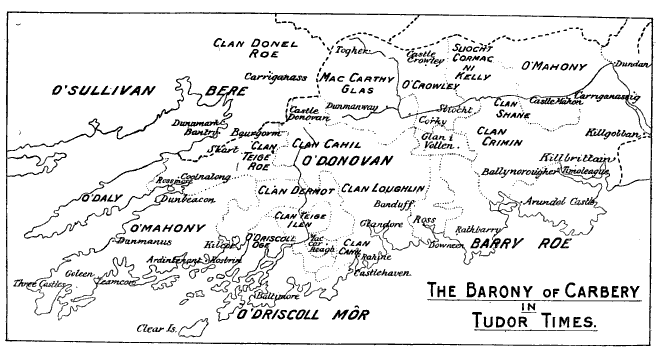
The Kingdom of Desmond () was a historic kingdom in southwestern Ireland. It was founded in 1118 by Tadhg Mac Cárthaigh, King of Munster when the Cormac Mac Cárthaigh#The Treaty of Glanmire, Treaty of Glanmire formally divided the Kingdom of Munster into Desmond and Thomond (, "North Munster"). It comprised all of what is now County Cork and most of County Kerry. Desmond was ruled by the MacCarthy dynasty, Mac Cárthaigh (MacCarthy) dynasty. Other clans within the kingdom included the O'Sullivan family, O'Sullivans and O'Donovan family, O'Donovans. Following the Norman invasion of Ireland in the late 12th century, the eastern half of Desmond was conquered by the Anglo-Normans and became the Earl of Desmond, Earldom of Desmond, ruled by the Fitzmaurices and FitzGerald (surname), FitzGeralds—the famous Irish family known as the Geraldines. The king of Desmond, Diarmaid Mac Cárthaigh submitted to Henry II of England, but the western half of Desmond lived on as a semi-independ ... [...More Info...] [...Related Items...] OR: [Wikipedia] [Google] [Baidu] |
Baronies Of Ireland
In Ireland, a barony (, plural ) is a historical subdivision of a county, analogous to the hundreds into which the counties of England were divided. Baronies were created during the Tudor reconquest of Ireland, replacing the earlier cantreds formed after the original Norman invasion.Mac Cotter 2005, pp.327–330 Some early baronies were later subdivided into half baronies with the same standing as full baronies. Baronies were mainly cadastral rather than administrative units. They acquired modest local taxation and spending functions in the 19th century before being superseded by the Local Government (Ireland) Act 1898. Subsequent adjustments of county boundaries mean that some baronies now straddle two counties. The final catalogue of baronies numbered 331, with an average area of ; each county was divided, on average, into 10 or 11 baronies. Creation The island of Ireland was "shired" into counties in two distinct periods: the east and south during the Anglo-Norman peri ... [...More Info...] [...Related Items...] OR: [Wikipedia] [Google] [Baidu] |
Túath
''Túath'' (plural ''túatha'') is the Old Irish term for the basic political and jurisdictional unit of Gaelic Ireland. ''Túath'' can refer to both a geographical territory as well the people who lived in that territory. The smallest ''túath'' controlled by a king was about the size of a later Irish barony (about 177sq miles) and kings with greater power would have two or more ''túatha'' under their control, according to ''A Smaller Social History of Ancient Ireland.'' '' Social structure In ancient Irish terms, a household was reckoned at about 30 people per dwelling. A ''trícha cét'' ("thirty hundreds"), was an area comprising 100 dwellings or, roughly, 3,000 people. A ''túath'' consisted of a number of allied ''trícha céta'', and therefore referred to no fewer than 6,000 people. Probably a more accurate number for a ''túath'' would be no fewer than 9,000 people. Each ''túath'' was a self-contained unit, with its own executive, assembly, courts system and defence ... [...More Info...] [...Related Items...] OR: [Wikipedia] [Google] [Baidu] |


