|
Progradation
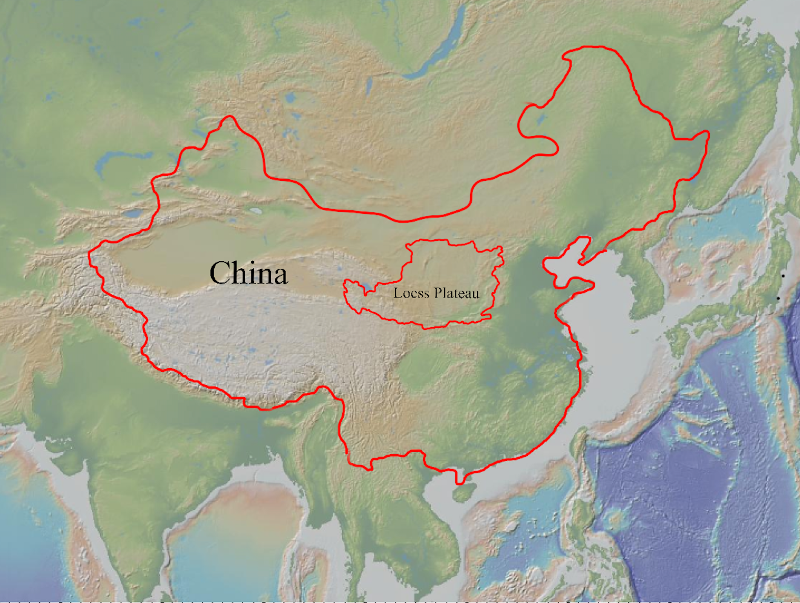
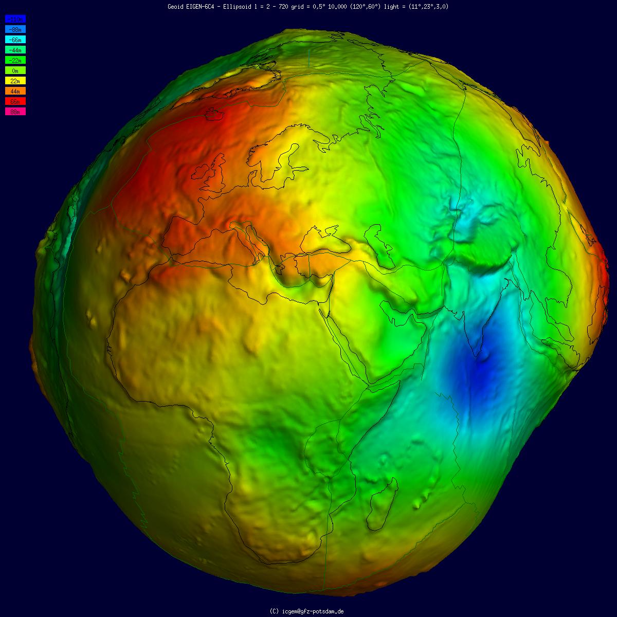
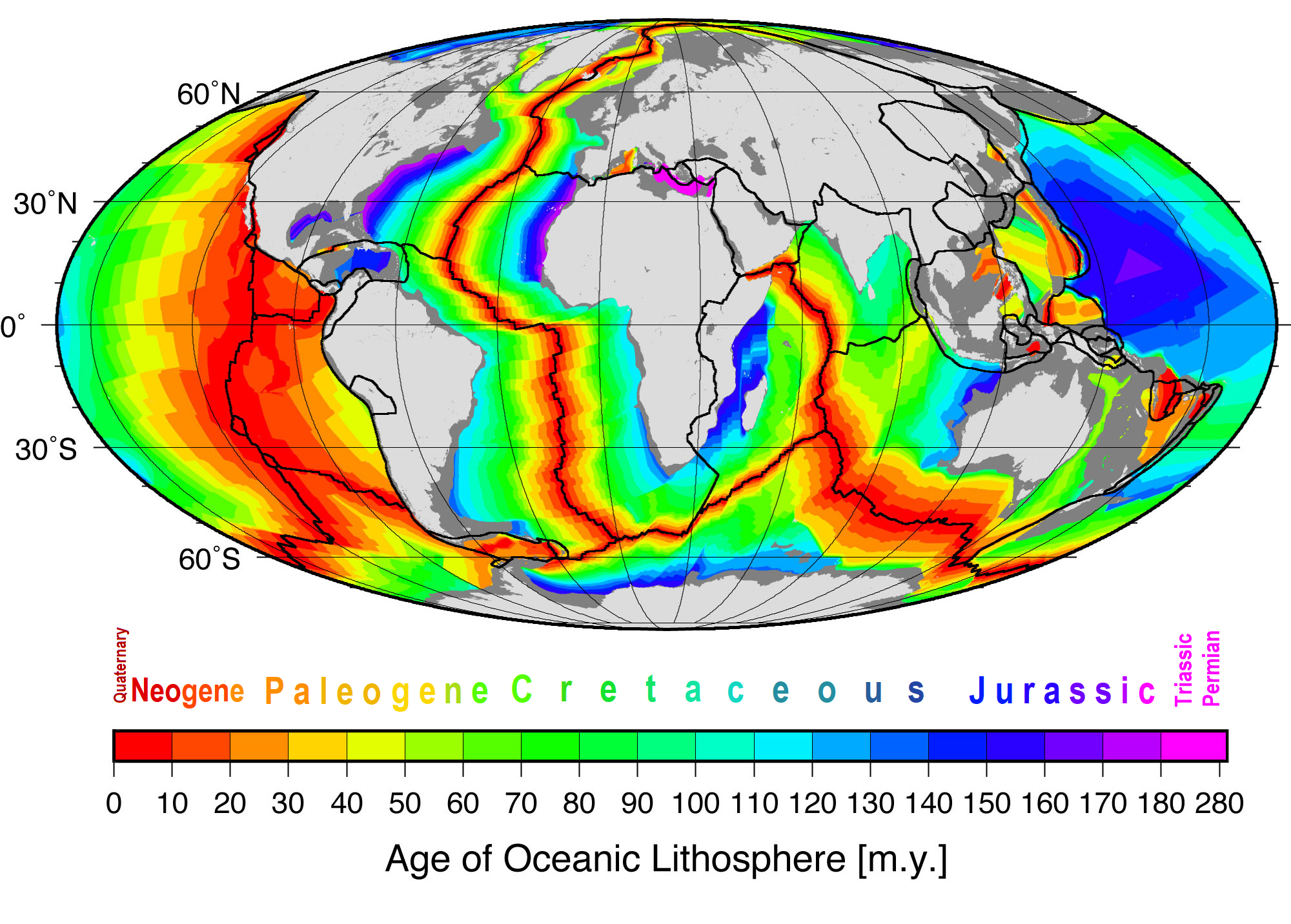
In sedimentary geology and geomorphology, the term progradation refers to the growth of a river delta farther out into the sea over time. This occurs when the volume of incoming sediment is greater than the volume of the delta that is lost through subsidence, sea-level rise, or erosion. Progradation can be caused by: * Periods of sea-level fall which result in marine regression. This can occur during major continental glaciations within ice ages, be caused by changes in the rates of seafloor spreading that affects the volume of the ocean basins, or tectonic effects on the regional mantle density structure that can change the geoid elevation. * Extremely high sediment input, such as by the Huang He (Yellow River) in China, which drains the Loess plateau The Chinese Loess Plateau, or simply the Loess Plateau, is a plateau in north-central China formed of loess, a clastic silt-like sediment formed by the accumulation of wind-blown dust. It is located southeast of the Gob ... [...More Info...] [...Related Items...] OR: [Wikipedia] [Google] [Baidu] |
Sedimentary Geology
''Sedimentary Geology'' is a peer-reviewed scientific journal about sediments in a geological context published by Elsevier Elsevier () is a Dutch academic publishing company specializing in scientific, technical, and medical content. Its products include journals such as '' The Lancet'', '' Cell'', the ScienceDirect collection of electronic journals, '' Trends'', .... About its scope the journal states it ranges "from techniques of sediment analysis to geodynamical aspects of sedimentary-basin evolution.". External links * {{Official website, http://www.journals.elsevier.com/sedimentary-geology/ Geology journals English-language journals Sedimentology Sedimentary rocks Sedimentary basins ... [...More Info...] [...Related Items...] OR: [Wikipedia] [Google] [Baidu] |
Glaciation
A glacial period (alternatively glacial or glaciation) is an interval of time (thousands of years) within an ice age that is marked by colder temperatures and glacier advances. Interglacials, on the other hand, are periods of warmer climate between glacial periods. The Last Glacial Period ended about 15,000 years ago. The Holocene is the current interglacial. A time with no glaciers on Earth is considered a greenhouse climate state. Quaternary Period Within the Quaternary, which started about 2.6 million years before present, there have been a number of glacials and interglacials. At least eight glacial cycles have occurred in the last 740,000 years alone. Penultimate Glacial Period The Penultimate Glacial Period (PGP) is the glacial period that occurred before the Last Glacial Period. It began about 194,000 years ago and ended 135,000 years ago, with the beginning of the Eemian interglacial. Last Glacial Period The last glacial period was the most recent glacial peri ... [...More Info...] [...Related Items...] OR: [Wikipedia] [Google] [Baidu] |
Proglacial River
A proglacial river is a river that flows from the margin of a glacier. These rivers are strongly affected by the highly-seasonal water supply from the glacier and by the large supply of sediment that arrives at the glacier terminus. This high sediment supply often makes them steep and braided. Many modern proglacial rivers drain glaciers in the mountain ranges of Alaska and the Himalayas. Past and present proglacial rivers in front of large ice sheets deposited large outwash plain An outwash plain, also called a sandur (plural: ''sandurs''), sandr or sandar, is a plain formed of glaciofluvial deposits due to meltwater outwash at the terminus of a glacier. As it flows, the glacier grinds the underlying rock surface and ca ...s of sediment. References {{geology-stub Fluvial geomorphology River morphology Glacial landforms ... [...More Info...] [...Related Items...] OR: [Wikipedia] [Google] [Baidu] |
Loess Plateau
The Chinese Loess Plateau, or simply the Loess Plateau, is a plateau in north-central China formed of loess, a clastic silt-like sediment formed by the accumulation of wind-blown dust. It is located southeast of the Gobi Desert and is surrounded by the Yellow River. It includes parts of the Chinese provinces of Gansu, Shaanxi and Shanxi. The depositional setting of the Chinese Loess Plateau was shaped by the tectonic movement in the Neogene period, after which strong southeast winds caused by the East Asian Monsoon transported sediment to the plateau during the Quaternary period. The three main morphological types in the Loess Plateau are loess platforms, ridges and hills, formed by the deposition and erosion of loess. Most of the loess comes from the Gobi Desert and other nearby deserts. The sediments were transported to the Loess Plateau during interglacial periods by southeasterly prevailing winds and winter monsoon winds. After the deposition of sediments on the plateau ... [...More Info...] [...Related Items...] OR: [Wikipedia] [Google] [Baidu] |
China
China, officially the People's Republic of China (PRC), is a country in East Asia. It is the world's List of countries and dependencies by population, most populous country, with a Population of China, population exceeding 1.4 billion, slightly ahead of India. China spans the equivalent of five time zones and Borders of China, borders fourteen countries by land, the List of countries and territories by land borders, most of any country in the world, tied with Russia. Covering an area of approximately , it is the world's third List of countries and dependencies by area, largest country by total land area. The country consists of 22 provinces of China, provinces, five autonomous regions of China, autonomous regions, four direct-administered municipalities of China, municipalities, and two special administrative regions of China, Special Administrative Regions (Hong Kong and Macau). The national capital is Beijing, and the List of cities in China by population, most populous cit ... [...More Info...] [...Related Items...] OR: [Wikipedia] [Google] [Baidu] |
Yellow River
The Yellow River or Huang He (Chinese: , Mandarin: ''Huáng hé'' ) is the second-longest river in China, after the Yangtze River, and the sixth-longest river system in the world at the estimated length of . Originating in the Bayan Har Mountains in Qinghai province of Western China, it flows through nine provinces, and it empties into the Bohai Sea near the city of Dongying in Shandong province. The Yellow River basin has an east–west extent of about and a north–south extent of about . Its total drainage area is about . The Yellow River's basin was the birthplace of ancient Chinese, and, by extension, Far Eastern civilization, and it was the most prosperous region in early Chinese history. There are frequent devastating floods and course changes produced by the continual elevation of the river bed, sometimes above the level of its surrounding farm fields. Etymology Early Chinese literature including the '' Yu Gong'' or ''Tribute of Yu'' dating to the ... [...More Info...] [...Related Items...] OR: [Wikipedia] [Google] [Baidu] |
Geoid
The geoid () is the shape that the ocean surface would take under the influence of the gravity of Earth, including gravitational attraction and Earth's rotation, if other influences such as winds and tides were absent. This surface is extended through the continents (such as with very narrow hypothetical canals). According to Gauss, who first described it, it is the "mathematical figure of the Earth", a smooth but irregular surface whose shape results from the uneven distribution of mass within and on the surface of Earth. It can be known only through extensive gravitational measurements and calculations. Despite being an important concept for almost 200 years in the history of geodesy and geophysics, it has been defined to high precision only since advances in satellite geodesy in the late 20th century. All points on a geoid surface have the same geopotential (the sum of gravitational potential energy and centrifugal potential energy). The force of gravity acts everywher ... [...More Info...] [...Related Items...] OR: [Wikipedia] [Google] [Baidu] |
Seafloor Spreading
Seafloor spreading or Seafloor spread is a process that occurs at mid-ocean ridges, where new oceanic crust is formed through volcanic activity and then gradually moves away from the ridge. History of study Earlier theories by Alfred Wegener and Alexander du Toit of continental drift postulated that continents in motion "plowed" through the fixed and immovable seafloor. The idea that the seafloor itself moves and also carries the continents with it as it spreads from a central rift axis was proposed by Harold Hammond Hess from Princeton University and Robert Dietz of the U.S. Naval Electronics Laboratory in San Diego in the 1960s. The phenomenon is known today as plate tectonics. In locations where two plates move apart, at mid-ocean ridges, new seafloor is continually formed during seafloor spreading. Significance Seafloor spreading helps explain continental drift in the theory of plate tectonics. When oceanic plates diverge, tensional stress causes fractures to occu ... [...More Info...] [...Related Items...] OR: [Wikipedia] [Google] [Baidu] |
Ice Age
An ice age is a long period of reduction in the temperature of Earth's surface and atmosphere, resulting in the presence or expansion of continental and polar ice sheets and alpine glaciers. Earth's climate alternates between ice ages and greenhouse periods, during which there are no glaciers on the planet. Earth is currently in the Quaternary glaciation. Individual pulses of cold climate within an ice age are termed '' glacial periods'' (or, alternatively, ''glacials, glaciations, glacial stages, stadials, stades'', or colloquially, ''ice ages''), and intermittent warm periods within an ice age are called ''interglacials'' or ''interstadials''. In glaciology, ''ice age'' implies the presence of extensive ice sheets in both northern and southern hemispheres. By this definition, Earth is currently in an interglacial period—the Holocene. The amount of anthropogenic greenhouse gases emitted into Earth's oceans and atmosphere is predicted to prevent the next glacial period for t ... [...More Info...] [...Related Items...] OR: [Wikipedia] [Google] [Baidu] |
Marine Regression
A marine regression is a geological process occurring when areas of submerged seafloor are exposed above the sea level. The opposite event, marine transgression, occurs when flooding from the sea covers previously-exposed land. Evidence of marine regressions and transgressions occurs throughout the fossil record, and the fluctuations are thought to have caused or contributed to several mass extinctions, such as the Permian-Triassic extinction event (250 million years ago) and Cretaceous–Paleogene extinction event (66 Ma). During the Permian-Triassic extinction, the largest extinction event in the Earth's history, the global sea level fell 250 m (820 ft). A major regression could itself cause marine organisms in shallow seas to go extinct, but mass extinctions tend to involve both terrestrial and aquatic species, and it is harder to see how a marine regression could cause widespread extinctions of land animals. Regressions are, therefore, seen as correlates or symptoms of maj ... [...More Info...] [...Related Items...] OR: [Wikipedia] [Google] [Baidu] |
Geomorphology
Geomorphology (from Ancient Greek: , ', "earth"; , ', "form"; and , ', "study") is the scientific study of the origin and evolution of topographic and bathymetric features created by physical, chemical or biological processes operating at or near Earth's surface. Geomorphologists seek to understand why landscapes look the way they do, to understand landform and terrain history and dynamics and to predict changes through a combination of field observations, physical experiments and numerical modeling. Geomorphologists work within disciplines such as physical geography, geology, geodesy, engineering geology, archaeology, climatology, and geotechnical engineering. This broad base of interests contributes to many research styles and interests within the field. Overview Earth's surface is modified by a combination of surface processes that shape landscapes, and geologic processes that cause tectonic uplift and subsidence, and shape the coastal geography. Surface proc ... [...More Info...] [...Related Items...] OR: [Wikipedia] [Google] [Baidu] |
Sea Level
Mean sea level (MSL, often shortened to sea level) is an average surface level of one or more among Earth's coastal bodies of water from which heights such as elevation may be measured. The global MSL is a type of vertical datuma standardised geodetic datum A geodetic datum or geodetic system (also: geodetic reference datum, geodetic reference system, or geodetic reference frame) is a global datum reference or reference frame for precisely representing the position of locations on Earth or other p ...that is used, for example, as a chart datum in cartography and Navigation, marine navigation, or, in aviation, as the standard sea level at which atmospheric pressure is measured to Calibration, calibrate altitude and, consequently, aircraft flight levels. A common and relatively straightforward mean sea-level standard is instead the midpoint between a Tide, mean low and mean high tide at a particular location. Sea levels can be affected by many factors and are known to hav ... [...More Info...] [...Related Items...] OR: [Wikipedia] [Google] [Baidu] |


