|
Marine Stratocumulus
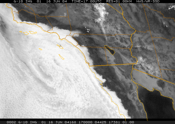
Marine stratocumulus is a type of stratocumulus cloud that form in the stable air off the west coast of major land masses. The Earth spins on its axis, which results in the Coriolis force pushing the ocean surface water away from the coast in the mid-latitudes. This results in upwelling of cold water from below that creates a pool of cool water at the surface, which in turn cools the air directly above it. The surface cooling results in a large temperature inversion at the top of the marine layer. As the temperature is cooled to the dewpoint, water vapor condenses upon available cloud condensation nuclei, and forms a cloud. The stability of the marine layer prevents deep convection, and thus stratiform clouds are formed. Climate scientists are currently investigating the detailed structure of marine stratocumulus clouds in an attempt to understand their effect on the climate. See also * Oceanic climate * Actinoform cloud * June Gloom June Gloom is a mainly Southern Califor ... [...More Info...] [...Related Items...] OR: [Wikipedia] [Google] [Baidu] |
Drizzle
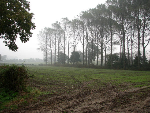
Drizzle is a light precipitation which consists of liquid water drops that are smaller than those of rain – generally smaller than in diameter. Drizzle is normally produced by low stratiform clouds and stratocumulus clouds. Precipitation rates from drizzle are on the order of a millimetre (0.04 in) per day or less at the ground. Owing to the small size of drizzle drops, under many circumstances drizzle largely evaporates before reaching the surface, and so may be undetected by observers on the ground. The METAR code for drizzle is DZ and for freezing drizzle is FZDZ. Effects While most drizzle has only a minor immediate impact upon humans, freezing drizzle can lead to treacherous conditions. Freezing drizzle occurs when supercooled drizzle drops land on a surface whose temperature is below freezing. These drops immediately freeze upon impact, leading to the buildup of sheet ice (sometimes called black ice) on the surface of roads. Occurrence Drizzle tends to ... [...More Info...] [...Related Items...] OR: [Wikipedia] [Google] [Baidu] |
Stratocumulus Cloud
A stratocumulus cloud, occasionally called a cumulostratus, belongs to a genus-type of clouds characterized by large dark, rounded masses, usually in groups, lines, or waves, the individual elements being larger than those in altocumulus, and the whole being at a lower height, usually below . Weak convective currents create shallow cloud layers (see also: sea of clouds) because of drier, stable air above preventing continued vertical development. Historically, in English, this type of cloud has been referred to as a twain cloud for being a combination of two types of clouds. Description Stratocumulus clouds are rounded clumps or patches of white to dark gray clouds that normally form in groups. The individual cloud elements, which cover more than 5 degrees of arc each, can connect with each other and are sometimes arranged in a regular pattern. Occurrence Vast areas of subtropical and polar ocean The ocean is the body of salt water that covers approximately 70.8% of E ... [...More Info...] [...Related Items...] OR: [Wikipedia] [Google] [Baidu] |
Coriolis Force
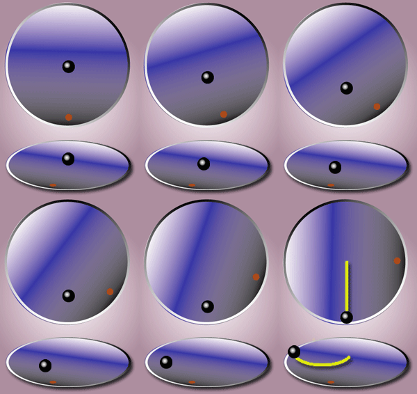
In physics, the Coriolis force is a pseudo force that acts on objects in motion within a frame of reference that rotates with respect to an inertial frame. In a reference frame with clockwise rotation, the force acts to the left of the motion of the object. In one with anticlockwise (or counterclockwise) rotation, the force acts to the right. Deflection of an object due to the Coriolis force is called the Coriolis effect. Though recognized previously by others, the mathematical expression for the Coriolis force appeared in an 1835 paper by French scientist Gaspard-Gustave de Coriolis, in connection with the theory of water wheels. Early in the 20th century, the term ''Coriolis force'' began to be used in connection with meteorology. Newton's laws of motion describe the motion of an object in an inertial (non-accelerating) frame of reference. When Newton's laws are transformed to a rotating frame of reference, the Coriolis and centrifugal accelerations appear. When applied ... [...More Info...] [...Related Items...] OR: [Wikipedia] [Google] [Baidu] |
Mid-latitudes
The middle latitudes, also called the mid-latitudes (sometimes spelled midlatitudes) or moderate latitudes, are spatial regions on either hemisphere of Earth, located between the Tropic of Cancer (latitude ) and the Arctic Circle () in the northern hemisphere and between the Tropic of Capricorn (-) and the Antarctic Circle (-) in the southern hemisphere. They include Earth's subtropical and temperate zones, which lie between the two tropics and the polar circles. Weather fronts and extratropical cyclones are usually found in this area, as well as occasional tropical cyclones or subtropical cyclones, which have traveled from their areas of formation closer to the Equator. The prevailing winds in the middle latitudes are often very strong. These parts of the world also see a wide variety of fast-changing weather as cold air masses from the poles and warm air masses from the tropics constantly push up and down over them against each other, sometimes alternating within hours of eac ... [...More Info...] [...Related Items...] OR: [Wikipedia] [Google] [Baidu] |
Upwelling
Upwelling is an physical oceanography, oceanographic phenomenon that involves wind-driven motion of dense, cooler, and usually nutrient-rich water from deep water towards the ocean surface. It replaces the warmer and usually nutrient-depleted surface water. The nutrient-rich upwelled water stimulates the growth and reproduction of primary producers such as phytoplankton. The biomass of phytoplankton and the presence of cool water in those regions allow upwelling zones to be identified by cool sea surface temperatures (SST) and high concentrations of chlorophyll a. The increased availability of nutrients in upwelling regions results in high levels of primary production and thus fishery production. Approximately 25% of the total global marine fish catches come from five upwellings, which occupy only 5% of the total ocean area.Jennings, S., Kaiser, M.J., Reynolds, J.D. (2001) "Marine Fisheries Ecology." Oxford: Blackwell Science Ltd. Upwellings that are driven by coastal ocean curr ... [...More Info...] [...Related Items...] OR: [Wikipedia] [Google] [Baidu] |
Temperature Inversion
In meteorology, an inversion (or temperature inversion) is a phenomenon in which a layer of warmer air overlies cooler air. Normally, air temperature gradually decreases as altitude increases, but this relationship is reversed in an inversion. An inversion traps air pollution, such as smog, near the ground. An inversion can also suppress convection by acting as a "cap". If this cap is broken for any of several reasons, convection of any humidity can then erupt into violent thunderstorms. Temperature inversion can cause freezing rain in cold climates. Normal atmospheric conditions Usually, within the lower atmosphere (the troposphere) the air near the surface of the Earth is warmer than the air above it, largely because the atmosphere is heated from below as solar radiation warms the Earth's surface, which in turn then warms the layer of the atmosphere directly above it, e.g., by thermals ( convective heat transfer). Air temperature also decreases with an increase in al ... [...More Info...] [...Related Items...] OR: [Wikipedia] [Google] [Baidu] |
Marine Layer
A marine layer is an air mass that develops over the surface of a large body of water, such as an ocean or large lake, in the presence of a Inversion (meteorology), temperature inversion. The inversion itself is usually initiated by the cooling effect caused when cold water on the surface of the ocean interacts with a comparatively warm air mass. Elements A marine layer can come in a number of different forms depending on the atmospheric conditions. It may manifest itself as merely a cool, humid air mass without any cloud cover, or it may be accompanied by clouds. In many cases, marine layers can consist of dense fog. Often associated with marine layers are Stratus cloud, stratus clouds, which are lumpy, often uniform clouds that form at low elevations (less than 3000 feet). Since marine layers are pushed ashore by westward winds, wind will almost always be present in one. Ultimately, the marine layer is a medium within which clouds may form under the right conditions; it is not ... [...More Info...] [...Related Items...] OR: [Wikipedia] [Google] [Baidu] |
Dewpoint
The dew point is the temperature the air needs to be cooled to (at constant pressure) in order to produce a relative humidity of 100%. This temperature depends on the pressure and water content of the air. When the air at a temperature above the dewpoint is cooled, its moisture capacity is reduced and airborne water vapor will condense to form liquid water known as dew. When this occurs through the air's contact with a colder surface, dew will form on that surface. The dew point is affected by the air's humidity. The more moisture the air contains, the higher its dew point. When the temperature is below the freezing point of water, the dew point is called the frost point, as frost is formed via deposition rather than condensation. In liquids, the analog to the dew point is the cloud point. Humidity If all the other factors influencing humidity remain constant, at ground level the relative humidity rises as the temperature falls; this is because the air's capacity to hold wa ... [...More Info...] [...Related Items...] OR: [Wikipedia] [Google] [Baidu] |
Stratus Cloud
Stratus clouds are low-level clouds characterized by horizontal layering with a uniform base, as opposed to convective or cumuliform clouds formed by rising thermals. The term ''stratus'' describes flat, hazy, featureless clouds at low altitudes varying in color from dark gray to nearly white. The word ''stratus'' comes from the Latin prefix ''Strato-'', meaning "layer" or "sheet". Stratus clouds may produce a light drizzle or a small amount of snow. These clouds are essentially above-ground fog formed either through the lifting of morning fog or through cold air moving at low altitudes. Some call these clouds "high fog" for their fog-like form. Formation Stratus clouds form when weak vertical currents lift a layer of air off the ground and it depressurizes, following the lapse rate. This causes the relative humidity to increase due to the adiabatic cooling. This occurs in environments where atmospheric ''stability'' is abundant. Description Stratus clouds look like ... [...More Info...] [...Related Items...] OR: [Wikipedia] [Google] [Baidu] |
Oceanic Climate
An oceanic climate, also known as a marine climate or maritime climate, is the temperate climate sub-type in Köppen climate classification, Köppen classification represented as ''Cfb'', typical of west coasts in higher middle latitudes of continents, generally featuring cool to warm summers and cool to mild winters (for their latitude), with a relatively narrow annual temperature range and few extremes of temperature. Oceanic climates can be found in both hemispheres generally between 40 and 60 degrees latitude, with subpolar versions extending to 70 degrees latitude in some coastal areas. Other varieties of climates usually classified together with these include subtropical highland climates, represented as ''Cwb'' or ''Cfb'', and subpolar oceanic or cold subtropical highland climates, represented as ''Cfc'' or ''Cwc''. Subtropical highland climates occur in some mountainous parts of the subtropics or tropics, some of which have monsoon influence, while their cold variants an ... [...More Info...] [...Related Items...] OR: [Wikipedia] [Google] [Baidu] |
Actinoform Cloud
An actinoform or actiniform describes a collection of marine low clouds that takes a distinct shape. They are named after the Greek word for "ray" due to their radial structure. Actinoform clouds can spread out over across and thus cannot be easily seen with the naked eye. In addition, actinoform clouds can form "trains" that are up to six times the length of the original cloud field, yet they maintain their own distinct identity. Description In a satellite image, they look like distinct leaf-like or spokes-on-a-wheel patterns that stand out from the rest of the low-lying cloud field. However, why they have this shape or how they are formed is not known, but recent evidence suggests that the interaction of both radiation and precipitation may help to organize them on the mesoscale. The individual convective cells that collectively make up an actinoform cloud are quite shallow, with heights generally less than , and would be classified as stratocumulus clouds by an observer on ... [...More Info...] [...Related Items...] OR: [Wikipedia] [Google] [Baidu] |
June Gloom
June Gloom is a mainly Southern California term for a weather pattern that results in cloud cover, cloudy, overcast skies with cool temperatures during the late spring and early summer. While the marine layer is most common in the month of June, it can occur in surrounding months, giving rise to other colloquialisms, such as Graypril, May Gray, No-Sky July, and Summer Bummer and Junuary in the Puget Sound region. Low-altitude stratus clouds form over the cool water of the California Current, and spread overnight into the coastal regions of California. The overcast skies often are accompanied by fog and drizzle, though usually not rain. June Gloom usually clears up between mid-morning and early afternoon, depending on the strength of the marine layer and the distance of the location from the Pacific Ocean, and gives way to sunny skies. May and June together are usually the cloudiest months in coastal California. June Gloom is stronger in years associated with a La Niña, and wea ... [...More Info...] [...Related Items...] OR: [Wikipedia] [Google] [Baidu] |


