|
County Of Kinross
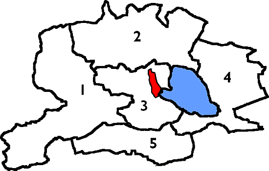
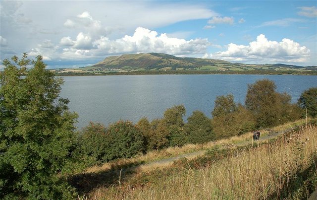
The County of Kinross or Kinross-shire is a Counties of Scotland, historic county and registration county in eastern Scotland, administered as part of Perth and Kinross since 1975. Surrounding its largest settlement and county town of Kinross, the county borders Perthshire to the north and Fife to the east, south and west. Scotland's second smallest county, Kinross-shire is dominated by Loch Leven (Kinross), Loch Leven, a large inland loch, with two islands and an internationally important nature reserve. One of the islands contains a castle, where Mary, Queen of Scots was once held prisoner. Much of the land in Kinross-shire is fertile agricultural land and most of the inhabitants were originally employed in farming. The gently-rolling farmland surrounding Loch Leven gives way to steep, more rugged terrain at the outskirts of the county. History Administrative history The Kinross-shire area was anciently part of the provinces of Scotland, province of Fothriff. By the early thir ... [...More Info...] [...Related Items...] OR: [Wikipedia] [Google] [Baidu] [Amazon] |
Shires Of Scotland
The counties or shires of Scotland () were historic subdivisions of Scotland. The shires were originally established in the Middle Ages for judicial purposes, being territories over which a Sheriff principal, sheriff had jurisdiction. They were distinct from the various older mormaerdoms, earldoms and other territories into which Scotland was also divided, which are collectively termed the provinces of Scotland by modern historians. The provinces gradually lost their functions, whereas the shires gradually gained functions. From the 16th century, the shires served as county constituency, constituencies, electing shire commissioners to the Parliament of Scotland. From 1667 each shire had Commissioners of Supply, commissioners of supply responsible for collecting local taxes; the commissioners of supply were subsequently given various local government functions as well. From 1797, the shires also served as areas for organising the militia, which was the responsibility of a lord-li ... [...More Info...] [...Related Items...] OR: [Wikipedia] [Google] [Baidu] [Amazon] |
Earl Of Fife
The Earl of Fife or Mormaer of Fife was the ruler of the province of Fife in medieval Scotland, which encompassed the modern counties of Fife and Kinross. Due to their royal ancestry, the earls of Fife were the highest ranking nobles in the realm, and had the right to crown the king of Scots. Held by the MacDuff family until it passed by resignation to the Stewarts, the earldom ended on the forfeiture and execution of Murdoch Stewart in 1425. The earldom was revived in 1759 with the style of Earl Fife for William Duff, a descendant of the MacDuffs. His great-great-grandson, the 6th Earl Fife, was made Earl of Fife in 1885 and Duke of Fife in 1889. Medieval earldom Mormaer of Fife The mormaers of Fife, by the 12th century, had established themselves as the highest ranking native nobles in Scotland. They frequently held the office of Justiciar of Scotia - highest brithem in the land - and enjoyed the right of crowning the kings of the Scots. The Mormaer's function, a ... [...More Info...] [...Related Items...] OR: [Wikipedia] [Google] [Baidu] [Amazon] |
County Buildings, Kinross
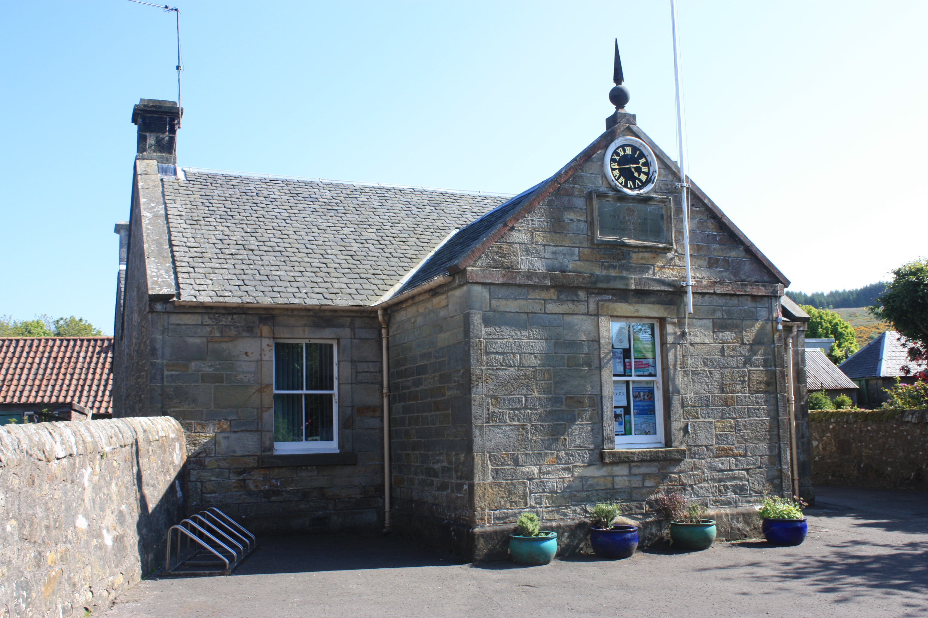
County Buildings is a municipal structure in the High Street in Kinross, Perth and Kinross Perth and Kinross (; ) is one of the 32 council areas of Scotland, and a Lieutenancy areas of Scotland, lieutenancy area. It is bordered by Highland (council area), Highland and Aberdeenshire to the north, Angus, Scotland, Angus, Dundee, and F ..., Scotland. The structure, which accommodates the local area offices for Perth and Kinross Council, is a Category B listed building. History The first county hall in Kinross-shire was a modest structure in the High Street which was completed in around 1600. It was primarily used as a courthouse and was repaired to a design by the architect and local Member of Parliament (United Kingdom), member of parliament, Robert Adam, in 1771. The design involved a prominent bowed frontage facing south down the High Street. In the 1820s, the local sheriff decided that a more substantial courthouse was needed: a suitable site, further north along the Hig ... [...More Info...] [...Related Items...] OR: [Wikipedia] [Google] [Baidu] [Amazon] |
Local Government (Scotland) Act 1889
The Local Government (Scotland) Act 1889 ( 52 & 53 Vict. c. 50) is an act of the Parliament of the United Kingdom which was passed on 26 August 1889. The main effect of the act was to establish elected county councils in Scotland. In this it followed the pattern introduced in England and Wales by the Local Government Act 1888 ( 51 & 52 Vict. c. 41). County councils The act provided that a county council should be established in each county, consisting of elected councillors. The term "county" was defined as excluding any royal burgh or parliamentary burgh, but with provisions that the county council would have powers over such burghs which met certain criteria, principally being those burghs which had fewer than 7,000 people at the time of the 1881 census. The burghs which remained independent of county council control were not listed in the act, but it was subsequently determined that there were 26 such burghs: *Aberdeen * Airdrie *Arbroath * Ayr *Brechin *Dumbarton *Dumfries ... [...More Info...] [...Related Items...] OR: [Wikipedia] [Google] [Baidu] [Amazon] |
Kinross-shire Offices And War Memorial (geograph 2406703)
The County of Kinross or Kinross-shire is a historic county and registration county in eastern Scotland, administered as part of Perth and Kinross since 1975. Surrounding its largest settlement and county town of Kinross, the county borders Perthshire to the north and Fife to the east, south and west. Scotland's second smallest county, Kinross-shire is dominated by Loch Leven, a large inland loch, with two islands and an internationally important nature reserve. One of the islands contains a castle, where Mary, Queen of Scots was once held prisoner. Much of the land in Kinross-shire is fertile agricultural land and most of the inhabitants were originally employed in farming. The gently-rolling farmland surrounding Loch Leven gives way to steep, more rugged terrain at the outskirts of the county. History Administrative history The Kinross-shire area was anciently part of the province of Fothriff. By the early thirteenth century, Fothriff had been joined to the earldom of Fife ... [...More Info...] [...Related Items...] OR: [Wikipedia] [Google] [Baidu] [Amazon] |
Acts Of Union 1707
The Acts of Union refer to two acts of Parliament, one by the Parliament of Scotland in March 1707, followed shortly thereafter by an equivalent act of the Parliament of England. They put into effect the international Treaty of Union agreed on 22 July 1706, which politically joined the Kingdom of England and Kingdom of Scotland into a single "political state" named Kingdom of Great Britain, Great Britain, with Anne, Queen of Great Britain, Queen Anne as its sovereign. The English and Scottish acts of ratification took effect on 1 May 1707, creating the new kingdom, with Parliament of Great Britain, its parliament based in the Palace of Westminster. The two countries had shared a monarch since the "personal" Union of the Crowns in 1603, when James VI of Scotland inherited the English throne from his cousin Elizabeth I to become (in addition) 'James I of England', styled James VI and I. Attempts had been made to try to unite the two separate countries, in 1606, 1667, and in ... [...More Info...] [...Related Items...] OR: [Wikipedia] [Google] [Baidu] [Amazon] |
Tullibole Castle
Tullibole Castle is a 17th-century castle in Crook of Devon, a village in Perth and Kinross Perth and Kinross (; ) is one of the 32 council areas of Scotland, and a Lieutenancy areas of Scotland, lieutenancy area. It is bordered by Highland (council area), Highland and Aberdeenshire to the north, Angus, Scotland, Angus, Dundee, and F .... It was built by John Halliday in 1608 and is currently owned by the Moncreiff family. The castle was designated a Category A listed building in 1971. History The first evidence of a building on the site was in 1304. The current castle began as a 16th-century tower house before it was expanded in 1608 by John Halliday who bought the land in 1589 from the Herring family. The castle was extended again later in the 18th century before it was passed by marriage to the Moncreiff family in around 1740. The interior of the castle and the gardens were renovated in the late 1950s. The name of the castle changed from Tulliebole Castle to Tullibole ... [...More Info...] [...Related Items...] OR: [Wikipedia] [Google] [Baidu] [Amazon] |
Portmoak
Portmoak is a Civil parishes in Scotland, parish in Kinross-shire, Scotland. It consists of a group of settlements running north to south: Glenlomond, Wester Balgedie, Easter Balgedie, Kinnesswood, Kilmagadwood and Scotlandwell. The name derives from the Port of St Moak (an alternative name for St Monan), being a port in relation to Loch Leven (Kinross), Loch Leven The main villages are Kinnesswood (where the Post Office is situated) and Scotlandwell. Geography The parish is on the east side of Kinross-shire lying between Loch Leven (Kinross), Loch Leven and Fife. It is bounded by the parishes of Cleish, Kinross, Orwell, Strathmiglo, Falkland, Leslie, Fife, Leslie, Kinglassie, Auchterderran and Ballingry. The area is a rich landscape of braes, crags, fine meadows, fertile fields and plantations. Bishop Hill The entire area of Portmoak is dominated by Bishop Hill, 1,512 ft (461 m) high, one of the Lomond Hills, known locally as "the bishop". On its lower reaches are ... [...More Info...] [...Related Items...] OR: [Wikipedia] [Google] [Baidu] [Amazon] |
Cleish
Cleish is a rural hamlet off the B9097 between Crook of Devon and the M90 motorway, three miles south-west of Kinross in central Scotland. It lies in the historic county of Kinross-shire. At the last census (2011), the population of the civil parish was 685.Census of Scotland 2011, Table KS101SC – Usually Resident Population, publ. by National Records of Scotland, web site www.scotlandscensus.gov.uk - See "Standard Outputs", Table KS101SC, Area type: Civil Parish Retrieved April 2021. The village is mentioned in Sir Walter Scott's novel ''The Abbot''. The majority of buildings date from the 18th century and the village retains much charm. The school dates from 1835. It is a designated conservation area. Cleish Castle lies to the west of the hamlet. Cleish Church The church can trace its roots to the 13th century and was originally dedicated to St. Cuthbert. The current church was built in 1775 by John Adam who lived nearby at Blair Adam. The church was again rebu ... [...More Info...] [...Related Items...] OR: [Wikipedia] [Google] [Baidu] [Amazon] |
Commissioners Of Supply
Commissioners of Supply were local administrative bodies in Scotland from 1667 to 1930. Originally established in each sheriffdom to collect tax, they later took on much of the responsibility for the local government of the counties of Scotland. In 1890 they ceded most of their duties to the county councils created by the Local Government (Scotland) Act 1889. They were finally abolished in 1930. Creation The Parliament of Scotland passed legislation creating Commissioners of Supply for each of the shires or sheriffdoms in 1667. The act specified that the commissioners for each sheriffdom should consist partly of ''ex officio'' members: all privy councillors and senators of the College of Justice "within the severall respective shyres wher any part of ther lands and estates doeth ly", and partly of nominated members: a number of named prominent landowners in each shire.The sheriffdoms listed were Edinburgh (i.e. Midlothian), Hadingtoun (i.e. East Lothian), Berwick, Roxburgh, ... [...More Info...] [...Related Items...] OR: [Wikipedia] [Google] [Baidu] [Amazon] |
Clackmannanshire
Clackmannanshire (; ; ), or the County of Clackmannan, is a Shires of Scotland, historic county, Council areas of Scotland, council area, registration counties, registration county and Lieutenancy areas of Scotland, lieutenancy area in Scotland, bordering the council areas of Stirling (council area), Stirling, Fife, and Perth and Kinross. To the south, it is separated from Falkirk (council area), Falkirk by the Firth of Forth. In terms of historic counties it borders Perthshire, Stirlingshire and Fife. The name consists of elements from three languages. The first element is from meaning "Stone". Mannan is a derivative of the Celtic mythology, Brythonic name of the Manaw Gododdin, Manaw, the Iron Age tribe who inhabited the area. The final element is the English word shire. As Britain's smallest historic county, it is often nicknamed "The Wee County". When written, Clackmannanshire is commonly abbreviated to Clacks. History Clackmannanshire takes its name from the original co ... [...More Info...] [...Related Items...] OR: [Wikipedia] [Google] [Baidu] [Amazon] |
Orwell, Kinross-shire
Orwell is a parish in Kinross-shire, Scotland. It contains the market town of Milnathort, as well as the hamlet of Middleton. The name comes from the Gaelic ''iubhar coille'' meaning "yew wood". The parish has an area of about . In the south it is quite flat, gradually becoming hillier further north, until one reaches the Ochil Hills at the northern boundary. In addition to Milnathort and Middleton, it contains several farms, some standing stones and Burleigh Castle. Its population was 3005 in 1831, dropped to 1983 in 1911, and rose to 2043 in 1951. The Church of Scotland parish of Orwell and Portmoak includes Orwell church in Milnathort and Portmoak church in Scotlandwell Scotlandwell is a village in Portmoak, Kinross-shire, Scotland. It is within the Perth and Kinross council area. It lies to the east of Loch Leven (Kinross), Loch Leven, at the junction of the A911 road, A977 and B920 roads, approximately west .... See also * Thomas Mair References External link ... [...More Info...] [...Related Items...] OR: [Wikipedia] [Google] [Baidu] [Amazon] |


