|
Canton Of St. Gallen
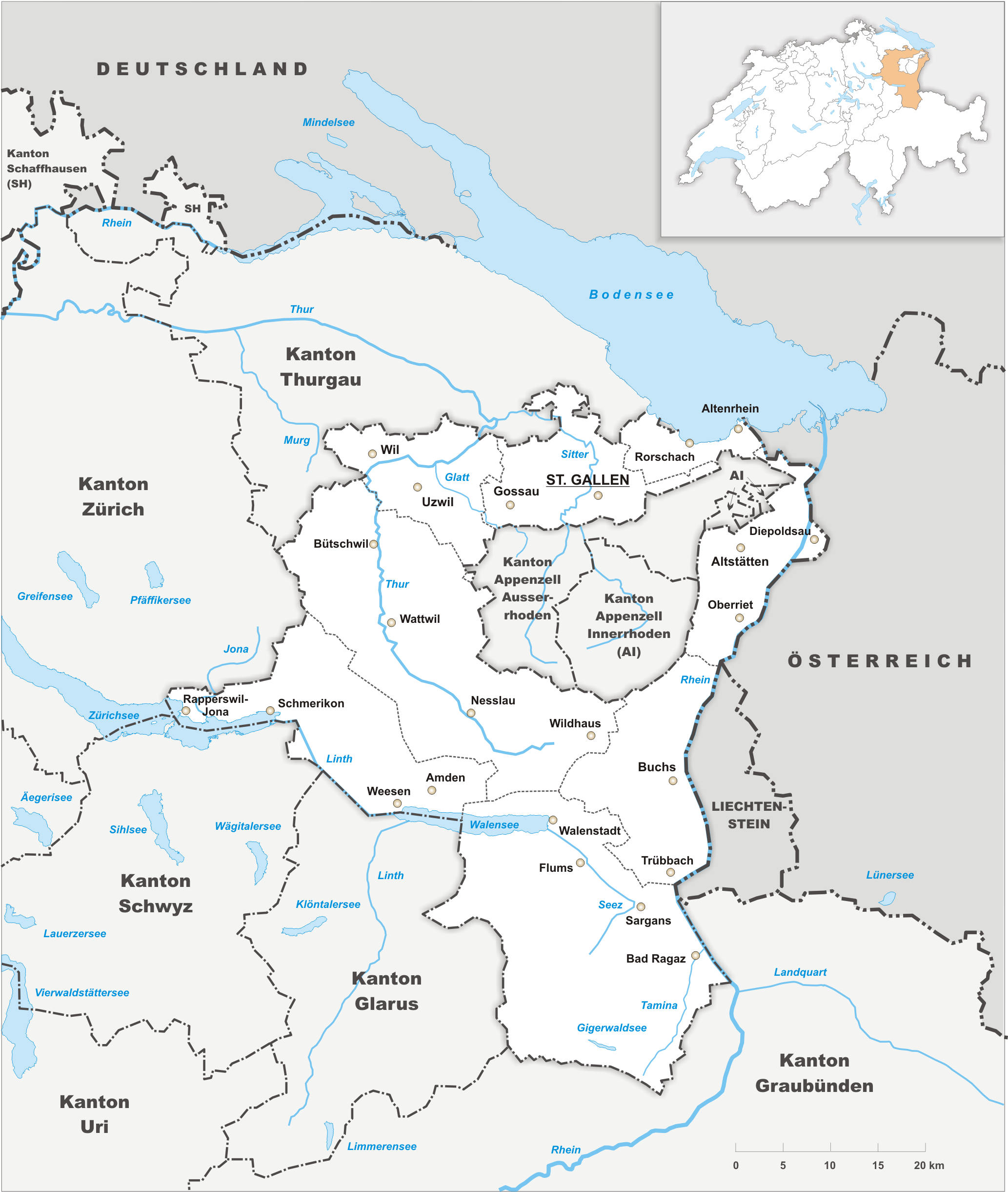
The canton of St. Gallen or St Gall ( ; ; ; ) is a canton of Switzerland. Its capital is St. Gallen. Located in northeastern Switzerland, the canton has an area of (5% of Switzerland) and a resident population close to half a million as of 2015 (6% of Switzerland). It was formed in 1803 as a conflation of the city of St. Gallen, the territories of the Abbey of St. Gall and various former subject territories of the Old Swiss Confederacy. History The canton of St. Gallen is an artificial construct of various historical territories, defined by Napoleon Bonaparte in the Act of Mediation in 1803. About half of the canton's area corresponds to the acquisitions of the abbey of St. Gallen over centuries. The city of St. Gallen became independent of the abbey in 1405. At the same time, the abbey lost control of Appenzell. Conversely, the Toggenburg was acquired by the Abbey in 1468. Both the city and the abbey were associates ('' Zugewandte Orte'') of the Old Swiss Confederac ... [...More Info...] [...Related Items...] OR: [Wikipedia] [Google] [Baidu] |
Cantons Of Switzerland
The 26 cantons of Switzerland are the Federated state, member states of the Switzerland, Swiss Confederation. The nucleus of the Swiss Confederacy in the form of the first three confederate allies used to be referred to as the . Two important periods in the development of the Old Swiss Confederacy are summarized by the terms ('Eight Cantons'; from 1353 to 1481) and ('Thirteen Cantons', from 1513 to 1798).rendered "the 'confederacy of eight'" and "the 'Thirteen-Canton Confederation'", respectively, in: Each canton of the Old Swiss Confederacy, formerly also ('lieu/locality', from before 1450), or ('estate', from ), was a fully sovereignty, sovereign state with its own border controls, army, and currency from at least the Treaty of Westphalia (1648) until the establishment of the Swiss federal state in 1848, with a brief period of centralised government during the Helvetic Republic (1798–1803). The term has been widely used since the 19th century. "" The number of canton ... [...More Info...] [...Related Items...] OR: [Wikipedia] [Google] [Baidu] |
Canton Of Linth
Linth was a canton of the Helvetic Republic from 1798 to 1803, consisting of Glarus and its subject County of Werdenberg, the Höfe and March districts of Schwyz and the Züricher subject Lordship of Sax, along with a handful of shared territories. Its capital was Glarus. The canton was named after the Linth river. Administration The canton contained approximately 78,500 inhabitants. Like all the cantons of the Helvetic Republic, Linth was established and administered on a French Revolutionary model. Linth and was divided administratively into seven districts * Werdenberg: ::capital Werdenberg, 30 electors, approx. 10,500 inhabitants * Neu St. Johann: ::capital Neu St. Johann, 30 electors, approx. 11,600 inhabitants * Mels: ::capital Mels, 25 electors, approx. 9,800 inhabitants * Schwanden: ::capital Schwanden, 29 electors, approx. 10,100 inhabitants * Glarus: ::capital Glarus, 38 electors, 12,700 inhabitants * Schänis ( Gaster): ::capital Schänis, 29 electors, 11,900 ... [...More Info...] [...Related Items...] OR: [Wikipedia] [Google] [Baidu] |
Glarus
Glarus (; ; ; ; ) is the capital of the canton of Glarus in Switzerland. Since 1 January 2011, the municipality of Glarus incorporates the former municipalities of Ennenda, Netstal and Riedern.Amtliches Gemeindeverzeichnis der Schweiz published by the Swiss Federal Statistical Office accessed 18 February 2011 Glarus lies on the river Linth between the foot of the Glärnisch (part of the Schwyzer Alps) to the west and the Schilt (Glarus Alps) to the east. Very few buildings built before the fire of 1861 remain. Wood, textile, and plastics, as well as printing, are the dominant industries. The symbol of the city is the neo-romanesque city church. History [...More Info...] [...Related Items...] OR: [Wikipedia] [Google] [Baidu] |
Canton Of Säntis
Säntis was the name of a canton of the Helvetic Republic from 1798 to 1803, consisting of the territory of St. Gallen, Appenzell Appenzell () was a cantons of Switzerland, canton in the northeast of Switzerland, and entirely surrounded by the canton of St. Gallen, in existence from 1403 to 1597. Appenzell became independent of the Abbey of Saint Gall in 1403 and entered ..., and Rheintal. Its capital was St. Gallen. References Cantons of the Helvetic Republic History of the canton of St. Gallen Appenzell Innerrhoden Appenzell Ausserrhoden {{Switzerland-hist-stub ... [...More Info...] [...Related Items...] OR: [Wikipedia] [Google] [Baidu] |
Rheintal (Wahlkreis)
The Wahlkreis Rheintal () is a constituency (''Wahlkreis'') of the canton of St. Gallen, Switzerland, formed under the new constitution of the canton on 10 June 2001. It consists largely of the former districts of Oberrheintal and Unterrheintal. The Wahlrkreis covers almost all the region of Vogtei Rheintal and later Rheintal District. Demographics Rheintal has a population of (as of ). Of the foreign population, (), 1,118 are from Germany, 1,978 are from Italy, 6,222 are from ex-Yugoslavia, 1,684 are from Austria, 850 are from Turkey, and 1,925 are from another country.Der Kanton St. Gallen und seine Menschen in Zahlen - Ausgabe 2009 accessed 30 December 2009 Of the Swiss national languages (), 54,669 speak |
Walensee
Lake Walen, also known as Lake Walenstadt or (), is one of the larger lakes in Switzerland. Located in the east of the country, about two thirds of its area are in the canton of St. Gallen and about one third in the canton of Glarus. Its name means 'Lake of the Walhaz' (), since in the early Middle Ages Lake Walen formed the linguistic border between the Alemanni, who settled in the west, and the Romansh people, the Walhaz (), in the east. Geography The lake lies in a valley between the Appenzell Alps to the north and the Glarus Alps to the south. It has a long east-west extension but is relatively narrow in north-south direction, with a surface area of . It has a maximum depth of . The three main tributaries of the lake are the Seez, Murgbach and Linth. The latter continues its course from Walensee to Obersee (Lake Zurich) through the Linth canal. Until the regulation of the Linth during the early 19th century, the Linth bypassed Walensee west of it and the lake's o ... [...More Info...] [...Related Items...] OR: [Wikipedia] [Google] [Baidu] |
Lake Zürich
Lake Zurich (, ; ) is a lake in Switzerland, extending southeast of the city of Zurich. Depending on the context, Lake Zurich or can be used to describe the lake as a whole, or just that part of the lake downstream of the Hurden peninsula and Seedamm causeway (between Pfäffikon, Schwyz, Pfäffikon and Rapperswil). In the latter case, the upstream part of the lake is called ''Obersee (Lake Zurich), Obersee'' (), while the lower part is sometimes also referred to as the Lower Lake (), respectively. Geography Lake Zurich is a glacial lake that was formed by the . Its main tributary is the River Linth, which rises in the glaciers of the Glarus Alps. The Linth originally flew directly into Lake Zurich, but was later diverted by the Hans Conrad Escher von der Linth, Escher canal (completed in 1811) into Lake Walen () from where its waters are now carried to the east end of Lake Zurich (near Schmerikon) by means of the straightened Linth canal (completed in 1816). Until the early ... [...More Info...] [...Related Items...] OR: [Wikipedia] [Google] [Baidu] |
Old Swiss Confederacy
The Old Swiss Confederacy, also known as Switzerland or the Swiss Confederacy, was a loose confederation of independent small states (, German or ), initially within the Holy Roman Empire. It is the precursor of the modern state of Switzerland. It formed at the end of the 13th century, from foundation of the Old Swiss Confederacy, a nucleus in what is now Central Switzerland, growth of the Old Swiss Confederacy, expanding to include the cities of Zurich and Bern by the middle of the 14th century. This formed a rare union of rural and urban medieval commune, communes, all of which enjoyed imperial immediacy in the Holy Roman Empire. This confederation of eight cantons () was politically and militarily successful for more than a century, culminating in the Burgundy Wars of the 1470s which established it as a power in the complicated political landscape dominated by Early modern France, France and the Habsburg monarchy, Habsburgs. Its success resulted in the addition of more con ... [...More Info...] [...Related Items...] OR: [Wikipedia] [Google] [Baidu] |
Zugewandte Orte
Swiss Associates, also known as Associated Places, Zugewandte Orte (Facing Places),Andreas Würgler: "Facing Places", in: ''Historical Lexicon of Switzerland (HLS)'' , version from February 26, 2014. Online: https://hls-dhs-dss.ch/de/articles/009815/2014-02-26/ , consulted on January 9, 2024. or Pays Alliés (Allied Countries), were associate states of the Old Swiss Confederacy, with some form of alliance agreement with either the entire Confederation or individual cantons. The associates were extremely heterogeneous. They had no institution that bound them together, other than their alliances with the Swiss Confederacy. Some had extremely close bonds with the Confederation, whereas others were only bound with one or two cantons. Generally, all nations that were related to the Confederation that were not subjects nor fully fledged cantons were considered associates. Whereas members of the Swiss Confederacy were not permitted to form alliances or ties with outside states without ... [...More Info...] [...Related Items...] OR: [Wikipedia] [Google] [Baidu] |
Toggenburg
Toggenburg is a region of Switzerland. It corresponds to the upper valley of the River Thur (Switzerland), Thur and that of the Necker (river), Necker, one of its afluents. Since 1 January 2003, Toggenburg has been a constituency (''Wahlkreis'') of the canton of St. Gallen (Community Identification Number#Switzerland, SFOS number 1727). Geography The valley descends in a northwestern direction from the watershed between the Rhine and the Thur, and is enclosed on the northeast by the chain of the Säntis () and on the southwest by that of the Churfirsten () and of the Speer (mountain), Speer (). It is a fertile valley of about in length from the source of the river to Wil. At Wildhaus, the highest village (), the house wherein Huldrych Zwingli, the Swiss Reformer, was born in 1484, is still shown. Other villages are Lichtensteig, Kirchberg, St. Gallen, Kirchberg and Wattwil. History There are traces of the Paleolithic Mousterian Industry throughout the Appenzell Alps, in the ... [...More Info...] [...Related Items...] OR: [Wikipedia] [Google] [Baidu] |
Appenzell
Appenzell () was a cantons of Switzerland, canton in the northeast of Switzerland, and entirely surrounded by the canton of St. Gallen, in existence from 1403 to 1597. Appenzell became independent of the Abbey of Saint Gall in 1403 and entered a league with the Old Swiss Confederacy in 1411, becoming a full member in 1513. It was partition (politics), divided into Appenzell Innerrhoden and Appenzell Ausserrhoden in 1597 (in a process called the :de:Landteilung_(Appenzell), Landteilung) as a result of the Swiss Reformation. The territory of Appenzell as a geographical entity is known as . While in political contexts, the two cantons (until 1999 half-cantons) are referred to as ('both Appenzells'). History Foundation The name ''Appenzell'' derives from 'cell (i.e., estate) of the abbot'. This refers to the Abbey of St. Gall, which exerted a great influence on the area. By the middle of the 11th century the abbots of St Gall had established their power in the land later calle ... [...More Info...] [...Related Items...] OR: [Wikipedia] [Google] [Baidu] |


