|
Alfisols
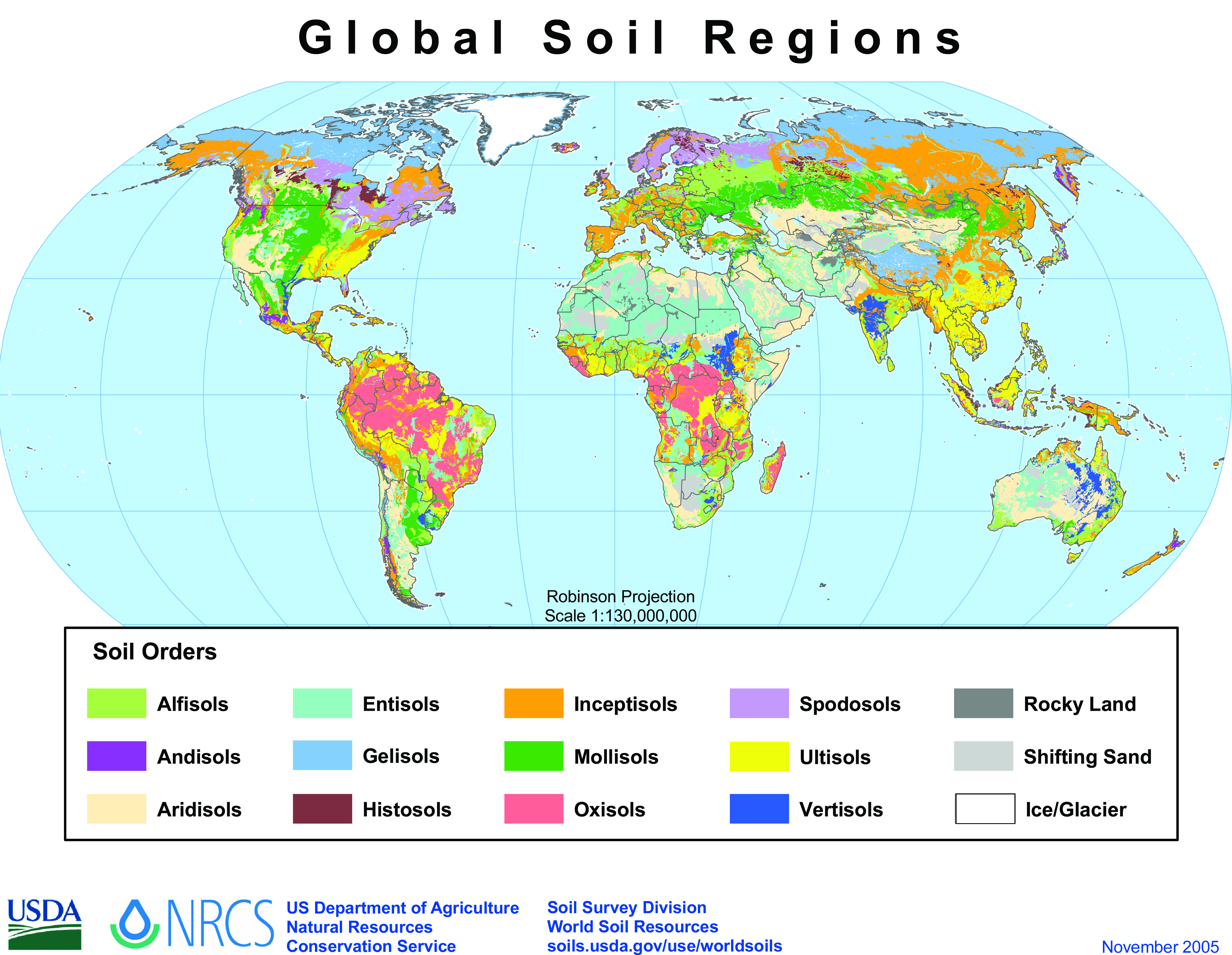
Alfisols are a soil order in USDA soil taxonomy. Alfisols form in semi-arid to humid areas, typically under a hardwood forest cover. They have a clay-enriched subsoil and relatively high native fertility. "Alf" refers to aluminium (Al) and iron (Fe). Because of their productivity and abundance, Alfisols represent one of the more important soil orders for food and fiber production. They are widely used both in agriculture and forestry, and are generally easier to keep fertile than other humid-climate soils, though those in Australia and Africa are still very deficient in nitrogen and available phosphorus. Those in monsoonal tropical regions, however, have a tendency to acidify when heavily cultivated, especially when nitrogenous fertilizers are used. In the World Reference Base for Soil Resources (WRB), most Alfisols are classified as Luvisols or Lixisols, but some are classed as Retisols or Nitisols. Aqualfs are mainly Stagnosols or Planosols. Alfisols with a natric horizon ar ... [...More Info...] [...Related Items...] OR: [Wikipedia] [Google] [Baidu] |
Nitisol
Nitisol, in the World Reference Base for Soil Resources (WRB), is a deep, red, well-drained soil with a clay content of at least 30% and a polyhedral structure or a blocky structure, breaking into a polyhedral or a flat-edged structure. The soil aggregates show pressure faces. Nitisols correlate with the kandic alfisols, ultisols and inceptisols of the USDA soil taxonomy. These soils are found in the tropics and subtropics; there are extensive areas of them in the tropical highlands of Ethiopia, Kenya, Democratic Republic of the Congo and Cameroon. Nitisols form from fine-textured material weathered from intermediate to basic parent rock and kaolinite, halloysite and iron oxides dominate their clay mineralogy. Nitisols are technically defined by a significant accumulation of clay (30 percent or more by mass and extending as much as 150 cm feetbelow the surface) and by a blocky aggregate structure. Iron oxides and high-water content are believed to play important roles in creat ... [...More Info...] [...Related Items...] OR: [Wikipedia] [Google] [Baidu] |
Oxisol
Oxisols are a soil order in USDA soil taxonomy, best known for their occurrence in tropical rain forest within 25 degrees north and south of the Equator. In the World Reference Base for Soil Resources (WRB), they belong mainly to the ferralsols, but some are plinthosols or nitisols. Some oxisols have been previously classified as laterite soils. Formation The main processes of soil formation of oxisols are weathering, humification and pedoturbation due to animals. These processes produce the characteristic soil profile. They are defined as soils containing ''at all depths'' no more than ten percent weatherable minerals, and low cation exchange capacity. Oxisols are always a red or yellowish color, due to the high concentration of iron(III) and aluminium oxides and hydroxides. They also contain quartz and kaolin, plus small amounts of other clay minerals and organic matter. Etymology The word "oxisol" comes from ''"oxide"'' in reference to the dominance of oxide mineral ... [...More Info...] [...Related Items...] OR: [Wikipedia] [Google] [Baidu] |
USDA Soil Taxonomy
USDA soil taxonomy (ST) developed by the United States Department of Agriculture and the National Cooperative Soil Survey provides an elaborate Soil classification, classification of soil types according to several parameters (most commonly their properties) and in several levels: ''Order'', ''Suborder'', ''Great Group'', ''Subgroup'', ''Family'', and ''Soil series, Series''. The classification was originally developed by Guy D. Smith, Guy Donald Smith, former director of the U.S. Department of Agriculture's soil survey investigations. Discussion A taxonomy is an arrangement in a systematic manner; the United States Department of Agriculture, USDA soil taxonomy has six levels of classification. They are, from most general to specific: order, suborder, great group, subgroup, family and series. Soil properties that can be measured quantitatively are used in this classification system – they include: depth, moisture, temperature, texture, structure, cation exchange capacity, base ... [...More Info...] [...Related Items...] OR: [Wikipedia] [Google] [Baidu] |
Solonetz
Solonetz (, rus, Солоне́ц, p=səlɐˈnʲɛts) is a Reference Soil Group of the World Reference Base for Soil Resources (WRB). They have, within the upper 100 cm of the soil profile, a so-called "natric horizon" ("natrium" is the Latin term for sodium). A subsurface horizon (subsoil), higher in clay content than the upper horizon, has more than 15% exchangeable sodium. The name is based on the Russian соль (sol, meaning salt). The Ukrainian folk word "solontsi" means salty soil. In Ukraine, many villages are called Solontsі. Solonetz zones are associated with Gleysols, Solonchaks and Kastanozems. In USDA soil taxonomy, Solonetz corresponds to sodium-rich Alfisols. See also * Chott *Salt marsh *Soil salinity Soil salinity is the salt (chemistry), salt content in the soil; the process of increasing the salt content is known as salinization (also called salination in American and British English spelling differences, American English). Salts occur nat ... * ... [...More Info...] [...Related Items...] OR: [Wikipedia] [Google] [Baidu] |
Guadalupian
The Guadalupian is the second and middle Series (stratigraphy), series/Epoch (geology), epoch of the Permian. The Guadalupian was preceded by the Cisuralian and followed by the Lopingian. It is named after the Guadalupe Mountains of New Mexico and Texas, and dates between 272.95 ± 0.5 – 259.1 ± 0.4 Mya. The series saw the rise of the therapsids, a minor extinction event called Olson's Extinction and a significant Extinction event, mass extinction called the end-Capitanian extinction event. The Guadalupian is also known as the Middle Permian. Name and background The Guadalupian is the second and middle series or epoch of the Permian. Previously called Middle Permian, the name of this epoch is part of a revision of Permian stratigraphy for standard global correlation. The name "Guadalupian" was first proposed in the early 1900s, and approved by the International Subcommission on Permian Stratigraphy in 1996. References to the Middle Permian still exist. The Guadalupian was p ... [...More Info...] [...Related Items...] OR: [Wikipedia] [Google] [Baidu] |
Devonian
The Devonian ( ) is a period (geology), geologic period and system (stratigraphy), system of the Paleozoic era (geology), era during the Phanerozoic eon (geology), eon, spanning 60.3 million years from the end of the preceding Silurian period at million years ago (Megaannum, Ma), to the beginning of the succeeding Carboniferous period at Ma. It is the fourth period of both the Paleozoic and the Phanerozoic. It is named after Devon, South West England, where rocks from this period were first studied. The first significant evolutionary radiation of history of life#Colonization of land, life on land occurred during the Devonian, as free-spore, sporing land plants (pteridophytes) began to spread across dry land, forming extensive coal forests which covered the continents. By the middle of the Devonian, several groups of vascular plants had evolved leaf, leaves and true roots, and by the end of the period the first seed-bearing plants (Pteridospermatophyta, pteridospermatophyt ... [...More Info...] [...Related Items...] OR: [Wikipedia] [Google] [Baidu] |
Paleopedological Record
{{inline citations, date=June 2013 The paleopedological record is, essentially, the fossil record of soils. The paleopedological record consists chiefly of paleosols buried by flood sediments, or preserved at geological unconformities, especially plateau escarpments or sides of river valleys. Other fossil soils occur in areas where volcanic activity has covered the ancient soils. Problems of recognition After burial, soil fossils tend to be altered by various chemical and physical processes. These include: * Decomposition of organic matter that was once present in the old soil. This hinders the recognition of vegetation that was in the soil when it was present. * Oxidation of iron from Fe2+ to Fe3+ by O2 as the former soil becomes dry and more oxygen enters the soil. * Drying out of hydrous ferric oxides to anhydrous oxides - again due to the presence of more available O2 in the dry environment. The keys to recognising fossils of various soils include: * Tubular structures th ... [...More Info...] [...Related Items...] OR: [Wikipedia] [Google] [Baidu] |
North America
North America is a continent in the Northern Hemisphere, Northern and Western Hemisphere, Western hemispheres. North America is bordered to the north by the Arctic Ocean, to the east by the Atlantic Ocean, to the southeast by South America and the Caribbean Sea, and to the south and west by the Pacific Ocean. The region includes Middle America (Americas), Middle America (comprising the Caribbean, Central America, and Mexico) and Northern America. North America covers an area of about , representing approximately 16.5% of Earth's land area and 4.8% of its total surface area. It is the third-largest continent by size after Asia and Africa, and the list of continents and continental subregions by population, fourth-largest continent by population after Asia, Africa, and Europe. , North America's population was estimated as over 592 million people in list of sovereign states and dependent territories in North America, 23 independent states, or about 7.5% of the world's popula ... [...More Info...] [...Related Items...] OR: [Wikipedia] [Google] [Baidu] |
Ultisols
Ultisol, commonly known as red clay soil, is one of twelve soil orders in the United States Department of Agriculture soil taxonomy. The word "Ultisol" is derived from "ultimate", because Ultisols were seen as the ultimate product of continuous weathering of minerals in a humid, temperate climate without new soil formation via glaciation. They are defined as mineral soils which contain no calcareous (calcium carbonate containing) material anywhere within the soil, have less than 10% weatherable minerals in the extreme top layer of soil, and have less than 35% base saturation throughout the soil. Ultisols occur in humid temperate or tropical regions. While the term is usually applied to the red clay soils of the Southern United States, Ultisols are also found in regions of Africa, Asia, Australia and South America. In the World Reference Base for Soil Resources (WRB), most Ultisols are known as Acrisols and Alisols. Some belong to the Retisols or to the Nitisols. Aquults are ... [...More Info...] [...Related Items...] OR: [Wikipedia] [Google] [Baidu] |
South America
South America is a continent entirely in the Western Hemisphere and mostly in the Southern Hemisphere, with a considerably smaller portion in the Northern Hemisphere. It can also be described as the southern Subregion#Americas, subregion of the Americas. South America is bordered on the west by the Pacific Ocean, on the north and east by the Atlantic Ocean, and to the south by the Drake Passage; North America and the Caribbean Sea lie to the northwest. The continent includes twelve sovereign states: Argentina, Bolivia, Brazil, Chile, Colombia, Ecuador, Guyana, Paraguay, Peru, Suriname, Uruguay, and Venezuela; two dependent territory, dependent territories: the Falkland Islands and South Georgia and the South Sandwich Islands; and one administrative division, internal territory: French Guiana. The Dutch Caribbean ABC islands (Leeward Antilles), ABC islands (Aruba, Bonaire, and Curaçao) and Trinidad and Tobago are geologically located on the South-American continental shel ... [...More Info...] [...Related Items...] OR: [Wikipedia] [Google] [Baidu] |
Sudan
Sudan, officially the Republic of the Sudan, is a country in Northeast Africa. It borders the Central African Republic to the southwest, Chad to the west, Libya to the northwest, Egypt to the north, the Red Sea to the east, Eritrea and Ethiopia to the southeast, and South Sudan to the south. Sudan has a population of 50 million people as of 2024 and occupies 1,886,068 square kilometres (728,215 square miles), making it Africa's List of African countries by area, third-largest country by area and the third-largest by area in the Arab League. It was the largest country by area in Africa and the Arab League until the 2011 South Sudanese independence referendum, secession of South Sudan in 2011; since then both titles have been held by Algeria. Sudan's capital and most populous city is Khartoum. The area that is now Sudan witnessed the Khormusan ( 40000–16000 BC), Halfan culture ( 20500–17000 BC), Sebilian ( 13000–10000 BC), Qadan culture ( 15000–5000 BC), the war of Jebel ... [...More Info...] [...Related Items...] OR: [Wikipedia] [Google] [Baidu] |
Peninsular India
South India, also known as Southern India or Peninsular India, is the southern part of the Deccan Peninsula in India encompassing the states of Andhra Pradesh, Karnataka, Kerala, Tamil Nadu and Telangana as well as the Union territories of India, union territories of Lakshadweep and Puducherry (union territory), Puducherry, occupying 19.31% of India's area () and 20% of India's population. It is bound by the Bay of Bengal in the east, the Arabian Sea in the west and the Indian Ocean in the south. The geography of the region is diverse, with two mountain ranges, the Western Ghats, Western and Eastern Ghats, bordering the plateau heartland. The Godavari River, Godavari, Krishna River, Krishna, Kaveri River, Kaveri, Penna River, Penna, Tungabhadra River, Tungabhadra and Vaigai River, Vaigai rivers are important non-Perennial stream, perennial sources of water. Chennai, Bengaluru, Hyderabad, Telangana, Hyderabad, Coimbatore and Kochi are the List of million-plus urban agglomeration ... [...More Info...] [...Related Items...] OR: [Wikipedia] [Google] [Baidu] |


