|
Al-Nuqayb
Al-Nuqayb was a Palestinian Arab village in the Tiberias Subdistrict. It was depopulated during the 1948 Arab-Israeli War on May 15, 1948. It was located 10 km east across the lake from Tiberias. bordering the Wadi al-Muzaffar and Wadi Samakh. al-Nuqayb was named after the Bedouin tribe of 'Arab al-Nuqayb. Location The village was located on the eastern shore of Lake Tiberias, with the fortress Qal'at al-Hisn located just to the east. History In the 1880s most of the village land was purchased by the Bahá'u'lláh, while the villagers continued to farm as tenant farmers. British Mandate era In the 1920s, the land the Bahá'u'lláh had purchased was sold to the JNF. At the time of the 1922 census of Palestine conducted by the British Mandate authorities, Nuqhaib had a population of 103 Muslims,Barron, 1923, Table XI, p 39/ref> increasing in the 1931 census to 287 Muslims, in 60 houses.Mills, 1932, p 84/ref> The Kibbutz of Ein Gev was established in 1937, 1,5 km sout ... [...More Info...] [...Related Items...] OR: [Wikipedia] [Google] [Baidu] [Amazon] |
Tiberias Subdistrict, Mandatory Palestine
Tiberias Subdistrict (; ) was one of the subdistricts of Mandatory Palestine, and as of 1945 it was part of the Galilee District. According to the 1947 partition plan, the district was to belong entirely to the Jewish state. After the 1948 Arab-Israeli War, small areas south and east of the Sea of Galilee were conquered by the Syrian Army and became No Man's Land, while the whole of the sub-district became the modern Kineret sub-district Kinneret County in the North District Borders * Safad Subdistrict (North) * Acre Subdistrict (West) * Beisan Subdistrict (South) * Nazareth Subdistrict (West) * Syria (East) Depopulated towns and villages * Awlam * al-Dalhamiyya * Ghuwayr Abu Shusha * Hadatha * al-Hamma * Hittin * Kafr Sabt * Lubya * Ma'dhar * al-Majdal * al-Manara * al-Manshiyya * al-Mansura * Nasir ad-Din * Nimrin * al-Nuqayb * Samakh * al-Samakiyya * al-Samra * al-Shajara * Tabgha * Al-'Ubaydiyya * Khirbat al-Wa'ra al-Sawda' * Yaquq Yaquq () ... [...More Info...] [...Related Items...] OR: [Wikipedia] [Google] [Baidu] [Amazon] |
Mandatory Palestine
Mandatory Palestine was a British Empire, British geopolitical entity that existed between 1920 and 1948 in the Palestine (region), region of Palestine, and after 1922, under the terms of the League of Nations's Mandate for Palestine. After an Arab Revolt, Arab uprising against the Ottoman Empire during the First World War in 1916, British Empire, British Egyptian Expeditionary Force, forces drove Ottoman Empire, Ottoman forces out of the Levant. The United Kingdom had agreed in the McMahon–Hussein Correspondence that it would honour Arab independence in case of a revolt but, in the end, the United Kingdom and French Third Republic, France divided what had been Ottoman Syria under the Sykes–Picot Agreement—an act of betrayal in the eyes of the Arabs. Another issue was the Balfour Declaration of 1917, in which Britain promised its support for the establishment of a Homeland for the Jewish people, Jewish "national home" in Palestine. Mandatory Palestine was then establishe ... [...More Info...] [...Related Items...] OR: [Wikipedia] [Google] [Baidu] [Amazon] |
1931 Census Of Palestine
The 1931 census of Palestine was the second census carried out by the authorities of Mandatory Palestine. It was carried out on 18 November 1931 under the direction of Major E. Mills after the 1922 census of Palestine. * Census of Palestine 1931, Volume I. Palestine Part I, Report. Alexandria, 1933 (349 pages). * Census of Palestine 1931, Volume II. Palestine, Part II, Tables. Alexandria, 1933 (595 pages). References Further reading * Miscellaneous short extracts from the census reports at Emory University * J. McCarthy, The Population of Palestine, Columbia University Press (1988). This contains many pages of tables extracted from the census reports. {{Authority control Censuses in Mandatory Palestine Census Of Palestine, 1931 Documents of Mandatory Palestine Palestine Palestine, officially the State of Palestine, is a country in West Asia. Recognized by International recognition of Palestine, 147 of the UN's 193 member states, it encompasses the Israeli-occupie ... [...More Info...] [...Related Items...] OR: [Wikipedia] [Google] [Baidu] [Amazon] |
Sha'ab, Israel
Sha'ab (; ; meaning "The spur") is an Arab localities in Israel, Arab town and local council (Israel), local council in the Northern District (Israel), Northern District of Israel. It has an area of 5,442 dunams () of land under its jurisdiction. In its population was . History French scholar Victor Guérin associated Sha'ab with ''Saab'', a place mentioned by 1st-century Jewish historian Josephus. The ''Midrash Rabba'' (Leviticus Rabba s. 20,9) mentions a certain Rabbi Mani of Sha'ab, together with Yehoshua of Sakhnin and Rabbi Johanan bar Nappaha. In the 14th century, the tax income from the village was given to the wakf of the madrasah and mausoleum of the Shafi'i Manjaq in Egypt. Ottoman era In 1517, Sha'ab was incorporated into the Ottoman Empire along with the rest of Palestine (region), Palestine. In 1573 (981 Hijri year, AH) Sha'ab was one of several villages in Galilee which rebelled against the Ottomans. In 1596, the village appeared in Ottoman Defter, tax registers a ... [...More Info...] [...Related Items...] OR: [Wikipedia] [Google] [Baidu] [Amazon] |
Syria
Syria, officially the Syrian Arab Republic, is a country in West Asia located in the Eastern Mediterranean and the Levant. It borders the Mediterranean Sea to the west, Turkey to Syria–Turkey border, the north, Iraq to Iraq–Syria border, the east and southeast, Jordan to Jordan–Syria border, the south, and Israel and Lebanon to Lebanon–Syria border, the southwest. It is a republic under Syrian transitional government, a transitional government and comprises Governorates of Syria, 14 governorates. Damascus is the capital and largest city. With a population of 25 million across an area of , it is the List of countries and dependencies by population, 57th-most populous and List of countries and dependencies by area, 87th-largest country. The name "Syria" historically referred to a Syria (region), wider region. The modern state encompasses the sites of several ancient kingdoms and empires, including the Eblan civilization. Damascus was the seat of the Umayyad Caliphate and ... [...More Info...] [...Related Items...] OR: [Wikipedia] [Google] [Baidu] [Amazon] |
Demilitarized Zone
A demilitarized zone (DMZ or DZ) is an area in which treaties or agreements between states, military powers or contending groups forbid military installations, activities, or personnel. A DZ often lies along an established frontier or boundary between two or more military powers or alliances. A DZ may sometimes form a ''de facto'' international border, such as the Korean Demilitarized Zone. Other examples of demilitarized zones are a wide area between Iraq and Kuwait; Antarctica (preserved for scientific exploration and study); and outer space (space more than from the Earth's surface). Some zones remain demilitarized after an agreement has awarded control to a state which (under the DZ terms) had originally ceded its right to maintain military forces in the disputed territory. It is also possible for powers to agree on the demilitarization of a zone without formally settling their respective territorial claims, enabling the dispute to be resolved by peaceful means such as d ... [...More Info...] [...Related Items...] OR: [Wikipedia] [Google] [Baidu] [Amazon] |
Safad Subdistrict, Mandatory Palestine
The Safad Subdistrict (; ) was one of the subdistricts of Mandatory Palestine before it was captured by Israel in 1948. It was located around the city of Safad. After the 1948 Arab-Israeli War, the subdistrict, which fell entirely within modern-day Israel, became the modern-day Safed Subdistrict in the Northern District (Israel). Borders * Acre Subdistrict (South West) * Tiberias Subdistrict (South) * Lebanon (North) * Syria (East) Depopulated towns and villages (current localities in parentheses) * Abil al-Qamh ( Yuval) * al-'Abisiyya * 'Akbara * Alma (Alma) * Ammuqa ('Ammuqa) * Arab al-Shamalina ( Almaghor) * Arab al-Zubayd * Baysamun * Biriyya ( Birya) * al-Butayha ( Almagor) * al-Buwayziyya * Dallata ( Dalton) * al-Dawwara ( 'Ammir, Sde Nehemia) * Dayshum (Dishon) * al-Dirbashiyya * al-Dirdara * Ein al-Zeitun * Fara * Farradiyya ( Parod, Shefer) * Fir'im ( Hatzor HaGlilit) * Ghabbatiyya * Ghuraba * al-Hamra' * Harrawi * Hunin ( Margaliot) * ... [...More Info...] [...Related Items...] OR: [Wikipedia] [Google] [Baidu] [Amazon] |
Kirad Al-Ghannama
Kirad al-Ghannama was a Palestinian Arab village in the Safad Subdistrict. It was depopulated during the 1947–1948 Civil War in Mandatory Palestine on April 22, 1948, by the Palmach's First Battalion of Operation Yiftach. It was located 11 km northeast of Safad. Wadi Mushayrifa ran between the two Kirad villages (al-Ghannama and al-Baqqara) and Wadi Waqqas supplied the village with its water requirements. The village contained the following khirbas: Khirbat Nijmat al-Subh, Tall al-Qadah, and Tall al-Safa. History By the 1931 census ''Arab Ghannameh'' had 265 Muslims inhabitants, in a total of 54 houses.Mills, 1932, p106/ref> In the 1945 statistics, its population was 350 Muslims, and the total land area were 3,975 dunams. Of this, 77 dunams were for citrus and bananas, 20 dunams were irrigated or used for plantations, 3,451 for cereals,Government of Palestine, Department of Statistics. Village Statistics, April, 1945. Quoted in Hadawi, 1970 p.119/ref> while 6 ... [...More Info...] [...Related Items...] OR: [Wikipedia] [Google] [Baidu] [Amazon] |
Kirad Al-Baqqara
Kirad al-Baqqara () was a Palestinian Arab village in the Safad Subdistrict. It was depopulated during the 1947–1948 Civil War in Mandatory Palestine on April 22, 1948, by the Palmach's First Battalion of Operation Yiftach. It was located 11 km northwest of Safad and Wadi Mushayrifa ran between the two Kirad villages (al-Ghannama and al-Baqqara). History British Mandate era In the British Mandate period, in the 1931 census Arab al-Baqqara had a population of 245 Muslims, in 34 houses.Mills, 1932, p105/ref> By the 1945 statistics the population was 360 Muslims, with a total of 2,262 dunams of land, according to an official land and population survey. Of this, a total of 1,961 dunums were used for cereals; 60 dunums were irrigated or used for plantations, while 120 dunams were non-cultivable area. 1948, aftermath In April 1948, large part of the population left the village after full-scale hostilities broke out. After the 1948 Palestine war, according to the armis ... [...More Info...] [...Related Items...] OR: [Wikipedia] [Google] [Baidu] [Amazon] |
Al-Samra
Al-Samra () was a Palestinian Arab village in the Tiberias Subdistrict. It was depopulated on April 21, 1948, during the 1947–1948 Civil War in Mandatory Palestine. It was located 10 km southeast of Tiberias. History The village had a mosque and several ''khirbas'' (ruined sites) including ''Khirbat al-Tawafiq'' and ''Khirbat Duwayraban''. Late Ottoman period In the early 19th century, Johann Ludwig Burckhardt noted it as the only village on the eastern shore of Lake Tiberias, and that it had some ancient buildings. In 1838, Edward Robinson was told that the village, ''Khurbet es-Sumrah'', was on the eastern shore of the lake. The villagers were Muslim. In 1875, Victor Guérin found here large ruins, which he misidentified as Hippos. A population list from about 1887 showed ''es Samr (east shore)'' to have about 180 inhabitants; 20 Druze and 160 Muslims. In 1914, an Ottoman airplane, on its way from Istanbul to Cairo, crashed by the village. Two pilots were killed. ... [...More Info...] [...Related Items...] OR: [Wikipedia] [Google] [Baidu] [Amazon] |
Al-Hamma, Tiberias
Al-Hamma () was a Palestinian Arab village in the Tiberias Subdistrict, southeast of Tiberias. It was situated on a narrow salient in the Yarmouk Valley bounded by Syria to the north and Transjordan to the south and east. Al-Hamma was one of the stations on the Jezreel Valley railway, linking the Hejaz Railway to Haifa. It was depopulated twice, once in July 1949, and again between 1949 and 1956. Etymology The name indicates the presence of hot water springs, as ''hammah'' is Arabic for "hot spring". History Emmatha, Roman and Byzantine periods During the Roman Empire it was known as Emmatha. During this period, Al-Hamma belonged to the district of Gadara. Early Muslim period Recent excavations have revealed a large Umayyad public building comprising several rooms with mosaic floors, set with red, black and white tesserae. The building seems to have been destroyed by the 749 Golan earthquake, but was rebuilt and used until finally abandoned after the earthquake of 10 ... [...More Info...] [...Related Items...] OR: [Wikipedia] [Google] [Baidu] [Amazon] |
Israel–Syria Mixed Armistice Commission
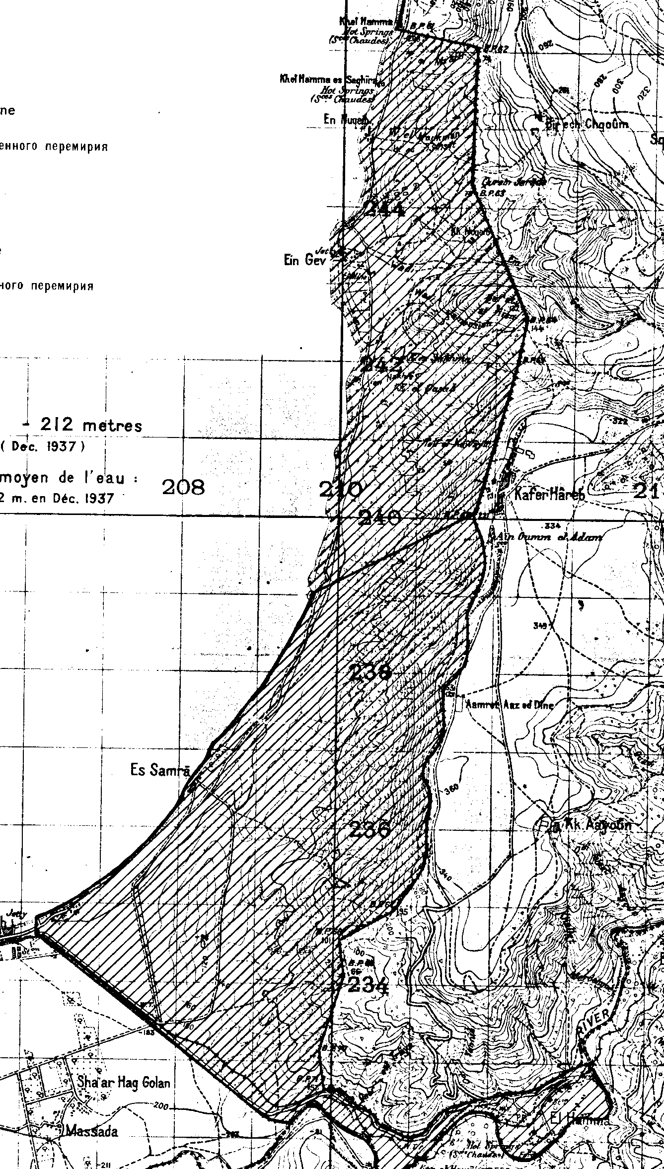
The Israel–Syria Mixed Armistice Commission (ISMAC) was the United Nations commission for observing the armistice between Israel and Syria after the 1948 Arab–Israeli War, as part of the Mixed Armistice Commissions (MAC). The fourth and last truce agreement, the 1949 armistice agreement, was signed between Israel and Syria on 20 July 1949 on Hill 232 near Mahanayim, ending the formal conflict in the former Mandatory Palestine. The Israeli side was represented by Lieutenant Colonel Mordechai Maklef, Yehoshua Penman and Shabtai Rosenne, while the Syrian side was represented by Colonel Fawzi Selo, Lieutenant Colonel Mohamed Nasser and Captain Afif Sizri. While the armistice agreements with Syria concluded the 1948 Arab–Israeli War, they did not mark the end of the Arab–Israeli conflict. A feature of the Israeli-Syrian General Armistice Agreement (GAA) was the provision for the establishment of a special demilitarized zone (DMZ) between the countries. The DMZ establish ... [...More Info...] [...Related Items...] OR: [Wikipedia] [Google] [Baidu] [Amazon] |


