|
Al-Fashir
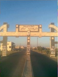
Al-Fashir or El Fasher () is the capital city of North Darfur, Sudan. It is a city in the Darfur region of southwestern Sudan, northeast of Nyala, Sudan. "Al-Fashir" (description) ''Encyclopædia Britannica'', 2007, webpage: A historical Caravan (travellers), caravan post, Al-Fashir is located at an elevation of about . The city serves as an agricultural marketing point for the cereals and fruits grown in the surrounding region. Al-Fashir is linked by road with both Geneina and Umm Keddada. Al-Fashir had 264,734 residents , an increase from 2001, when the population was estimated to be 178,500. UN Habitat reported a population of 500,000 for al-Fashir in 2009, attributing the increase to refugees and economic migrants. Al Fashir University was created in 1990 by decree of President Omar Hassan Ahmed Bashir, and was officially opened in February 1991 in premises west of El Fasher Airport and south of the El Fashir School. History Late in the 18th century, Sultan Abd-er-R ... [...More Info...] [...Related Items...] OR: [Wikipedia] [Google] [Baidu] |
Darfur Crisis
The War in Darfur, also nicknamed the Land Cruiser War, was a major armed conflict in the Darfur region of Sudan that began in February 2003 when the Sudan Liberation Movement (SLM) and the Justice and Equality Movement (JEM) rebel groups began fighting against the government of Sudan, which they accused of oppressing Darfur's non-Arab population. The government responded to attacks by carrying out a campaign of ethnic cleansing against Darfur's non-Arabs. This resulted in the death of hundreds of thousands of civilians and the indictment of Sudan's president, Omar al-Bashir, for genocide, war crimes, and crimes against humanity by the International Criminal Court. One side of the conflict is mainly composed of the Sudanese military, police, and the Janjaweed, a Sudanese militia group whose members are mostly recruited among Arabized indigenous Africans and a small number of Bedouin of the northern Rizeigat; the majority of other Arab groups in Darfur remained uninvolved. ... [...More Info...] [...Related Items...] OR: [Wikipedia] [Google] [Baidu] |
North Darfur
North Darfur State ( Wilāyat Šamāl Dārfūr; ''Shamal Darfor'') is one of the wilayat or states of Sudan. It is one of the five states composing the Darfur region. It has an area of 296,420 km2 and an estimated population of approximately 2,304,950 in 2018. Al-Fashir is the capital of the state. Other significant towns include Ailliet, Kebkabiya,"ولاية شمال دارفور (The state of North Darfur)" Sudanese Government site, in Arabic, accessed 9 September 2010 Kutum, Mellit (Malit), Tawilah and [...More Info...] [...Related Items...] OR: [Wikipedia] [Google] [Baidu] |
Geneina
Geneina (sometimes Al-Junaynah or ElGeneina; , lit. ''the little garden'') is a city in West Darfur, part of the dar Masalit region, in Sudan. It joined British Sudan at the end of 1919 through the Gilani Agreement, signed between the Masalit Sultanate and the United Kingdom, according to which it became a territory. Geneina is now the capital of the Sudanese state of West Darfur. As of 2022, it had a population of 538,390 pre-war being one of the most populated cities within the country. According to the UNICEF nearly the entire population are IDPs and a large part are still young children. During the 2023 Sudan conflict, the Battle of Geneina was fought. This event included the deadly Geneina massacre, in which, as of 19 August 2023, thousands of civilians were killed, mainly Masalits and other non-Arab tribes. The RSF took control of the city by 22 June. History The city has the biggest group of Masalit people in Sudan and Darfur. This group was heavily targ ... [...More Info...] [...Related Items...] OR: [Wikipedia] [Google] [Baidu] |
Darfur
Darfur ( ; ) is a region of western Sudan. ''Dār'' is an Arabic word meaning "home f – the region was named Dardaju () while ruled by the Daju, who migrated from Meroë , and it was renamed Dartunjur () when the Tunjur ruled the area. Darfur was an independent sultanate for several hundred years until 1874, when it fell to the Sudanese warlord Rabih az-Zubayr. The region was later invaded and incorporated into Sudan by Anglo-Egyptian forces in 1916. Richard Cockett Sudan: Darfur and the failure of an African state. 2010. Hobbs the Printers Ltd., Totten, Hampshire. As an administrative region, Darfur is divided into five federal states: Central Darfur, East Darfur, North Darfur, South Darfur and West Darfur. Because of the War in Darfur between Sudanese government forces and the indigenous population, the region has been in a state of humanitarian emergency and genocide since 2003. The factors include religious and ethnic rivalry, and the rivalry between farm ... [...More Info...] [...Related Items...] OR: [Wikipedia] [Google] [Baidu] |
Battle Of El Fasher
The siege of El Fasher is an ongoing battle for control of the town of El Fasher in North Darfur during the Sudan conflict. The first battle for the city took place between 15 and 20 April 2023, and resulted in a ceasefire that held until 12 May. Clashes broke out again between 12 and 29 May, and ended with a more stable ceasefire that lasted until August. By September, the city had become a haven for refugees across the region, without enough food and water. By December 2023, the United Nations was preparing to withdraw its political mission from Sudan. Nathaniel Raymond, a UN human rights investigator, said "if El Fasher falls, the RSF will be able to complete the genocide begun by the Janjaweed through ethnic cleansing of those they have not displaced or killed so far". Background War in Darfur In 2003, rebel movements in Southern Sudan, the predominantly non-Arab Justice and Equality Movement and Sudan People's Liberation Movement launched attacks against Sudanese A ... [...More Info...] [...Related Items...] OR: [Wikipedia] [Google] [Baidu] |
Flag Of Sudan
The flag of Sudan () was adopted on 20 May 1970 and consists of a horizontal red-white-black Triband (flag), tricolour with a green triangle at the hoist. The flag is based on the Arab Liberation Flag of the Egyptian Revolution of 1952. Whereas there is no fixed order for the Pan-Arab Colours of black, white, red, and green, flags using the Arab Liberation Colours (a subset of the Pan-Arab Colours) maintain a horizontal triband of equal stripes of red, white, and black, with green being used to distinguish the different flags from each other by way of green stars, Arabic script, or, in the case of Sudan, the green triangle along the hoist. In the original Arab Liberation Flag, green was used in the form of the flag of the Kingdom of Egypt and Sudan emblazoned on the breast of the Eagle of Saladin in the middle stripe. For 13 years from Sudan's independence in 1956 to History of Sudan (1969–85), the 1969 military coup of Gaafar Nimeiry, Sudan used a tricolour flag of blue-yell ... [...More Info...] [...Related Items...] OR: [Wikipedia] [Google] [Baidu] |
Wet Season
The wet season (sometimes called the rainy season or monsoon season) is the time of year when most of a region's average annual rainfall occurs. Generally, the season lasts at least one month. The term ''green season'' is also sometimes used as a euphemism by tourist authorities. Areas with wet seasons are dispersed across portions of the tropics and subtropics. Under the Köppen climate classification, for tropical climates, a wet season month is defined as a month where average precipitation is or more. In contrast to areas with savanna climates and monsoon regimes, Mediterranean climates have wet winters and dry summers. Dry and rainy months are characteristic of tropical seasonal forests: in contrast to tropical rainforests, which do not have dry or wet seasons, since their rainfall is equally distributed throughout the year.Elisabeth M. Benders-Hyde (2003)World Climates.Blue Planet Biomes. Retrieved on 2008-12-27. Some areas with pronounced rainy seasons will see a break ... [...More Info...] [...Related Items...] OR: [Wikipedia] [Google] [Baidu] |
Köppen Climate Classification
The Köppen climate classification divides Earth climates into five main climate groups, with each group being divided based on patterns of seasonal precipitation and temperature. The five main groups are ''A'' (tropical), ''B'' (arid), ''C'' (temperate), ''D'' (continental), and ''E'' (polar). Each group and subgroup is represented by a letter. All climates are assigned a main group (the first letter). All climates except for those in the ''E'' group are assigned a seasonal precipitation subgroup (the second letter). For example, ''Af'' indicates a tropical rainforest climate. The system assigns a temperature subgroup for all groups other than those in the ''A'' group, indicated by the third letter for climates in ''B'', ''C'', ''D'', and the second letter for climates in ''E''. Other examples include: ''Cfb'' indicating an oceanic climate with warm summers as indicated by the ending ''b.'', while ''Dwb'' indicates a semi-Monsoon continental climate, monsoonal continental climate ... [...More Info...] [...Related Items...] OR: [Wikipedia] [Google] [Baidu] |
Sahel
The Sahel region (; ), or Sahelian acacia savanna, is a Biogeography, biogeographical region in Africa. It is the Ecotone, transition zone between the more humid Sudanian savannas to its south and the drier Sahara to the north. The Sahel has a Semi-arid climate#Hot semi-arid climates, hot semi-arid climate and stretches across the tropics, southernmost latitudes of North Africa between the Atlantic Ocean and the Red Sea. Although geographically located in the tropics, the Sahel does not have a tropical climate. Especially in the western Sahel, there are droughts in the Sahel, frequent shortages of food and water due to its very high Corruption Perceptions Index, government corruption and the semi-arid climate. This is exacerbated by very high list of countries by birth rate, birthrates across the region, resulting in a rapid increase in population. In recent times, various Coup Belt, coups, Foreign internal defense#Preemptive counterinsurgency in Africa, insurgencies, terrorism ... [...More Info...] [...Related Items...] OR: [Wikipedia] [Google] [Baidu] |
Monsoon
A monsoon () is traditionally a seasonal reversing wind accompanied by corresponding changes in precipitation but is now used to describe seasonal changes in Atmosphere of Earth, atmospheric circulation and precipitation associated with annual latitudinal oscillation of the Intertropical Convergence Zone (ITCZ) between its limits to the north and south of the equator. Usually, the term monsoon is used to refer to the Wet season, rainy phase of a seasonally changing pattern, although technically there is also a dry phase. The term is also sometimes used to describe locally heavy but short-term rains. The major monsoon systems of the world consist of the Monsoon#Africa (West African and Southeast African), West African, Asian–Australian monsoon, Australian, the North American monsoon, North American, and South American monsoons. The term was first Glossary of the British Raj, used in English in British India and neighboring countries to refer to the big seasonal winds blowin ... [...More Info...] [...Related Items...] OR: [Wikipedia] [Google] [Baidu] |
National Oceanic And Atmospheric Administration
The National Oceanic and Atmospheric Administration (NOAA ) is an American scientific and regulatory agency charged with Weather forecasting, forecasting weather, monitoring oceanic and atmospheric conditions, Hydrography, charting the seas, conducting deep-sea exploration, and managing fishing and protection of marine mammals and endangered species in the US exclusive economic zone. The agency is part of the United States Department of Commerce and is headquartered in Silver Spring, Maryland. History NOAA traces its history back to multiple agencies, some of which are among the earliest in the federal government: * United States Coast and Geodetic Survey, formed in 1807 * National Weather Service, Weather Bureau of the United States, formed in 1870 * United States Fish Commission, Bureau of Commercial Fisheries, formed in 1871 (research fleet only) * NOAA Commissioned Corps, Coast and Geodetic Survey Corps, formed in 1917 The most direct predecessor of NOAA was the Enviro ... [...More Info...] [...Related Items...] OR: [Wikipedia] [Google] [Baidu] |


