|
Usa-224
__NOTOC__ USA-224, also known as NROL-49, is an American reconnaissance satellite. Launched in 2011 to replace the decade-old USA-161 satellite, it is the fifteenth KH-11 optical imaging satellite to reach orbit. Project history and cost After the Boeing-led Future Imagery Architecture program failed in 2005, the National Reconnaissance Office ordered two more KH-11s. Critics worried that each of these "exquisite-class" satellites would cost more than the Navy's latest aircraft carrier ( in 2005, or about $ today). Instead, USA-224–the first of these two–was completed by Lockheed under the initial budget estimate and two years ahead of schedule. Launch USA-224 was launched atop a Delta IV Heavy rocket from Vandenberg AFB Space Launch Complex 6 in California. The launch was conducted by United Launch Alliance, and was the first flight of a Delta IV Heavy from Vandenberg. Liftoff occurred on 20 January 2011 at 21:10:30 UTC. Upon reaching orbit, the satellite received th ... [...More Info...] [...Related Items...] OR: [Wikipedia] [Google] [Baidu] |
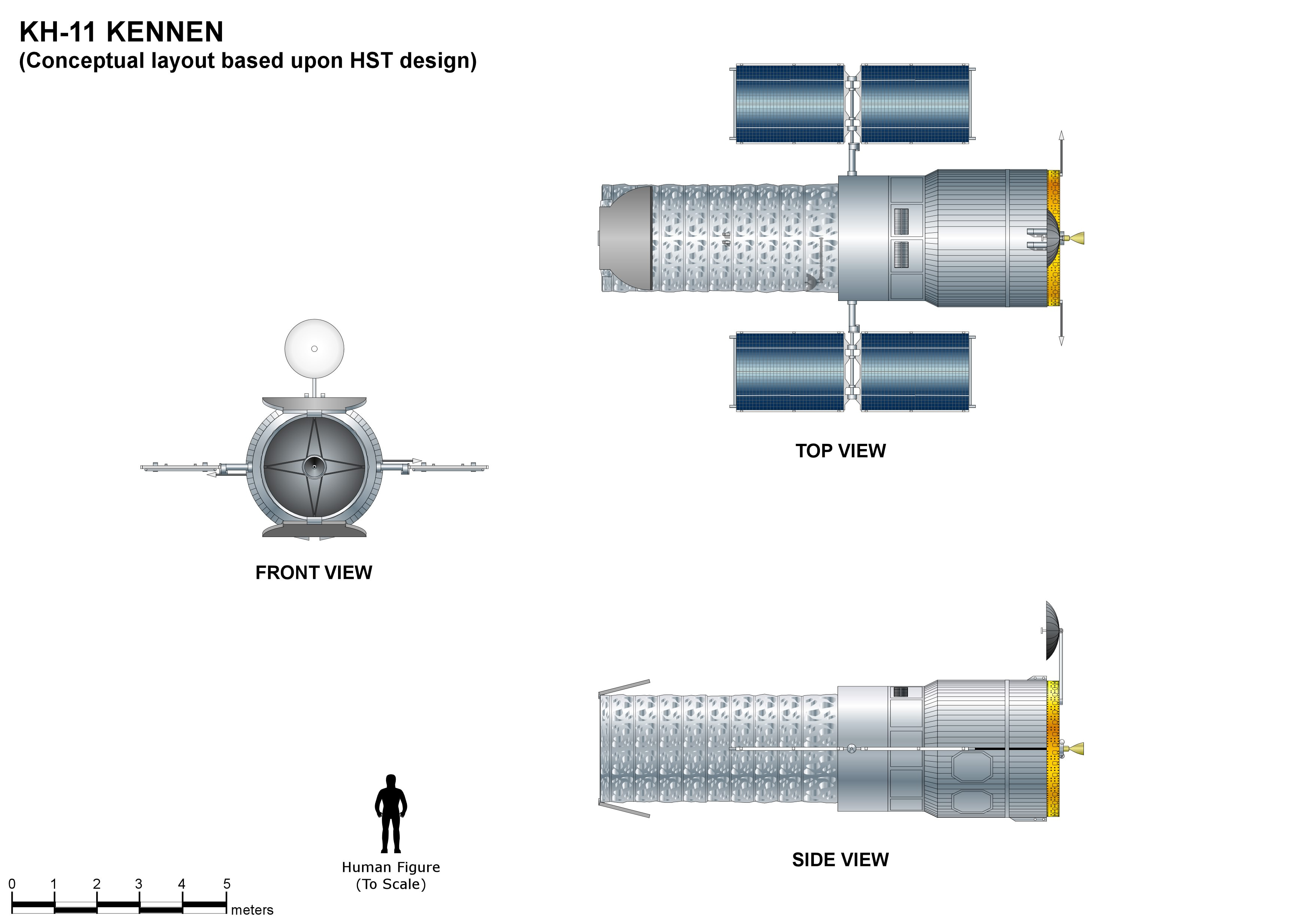
KH-11 Kennen
The KH-11 KENNEN (later renamed CRYSTAL,p.199-200 then Evolved Enhanced CRYSTAL System, and codenamed 1010 and Key Hole) is a type of reconnaissance satellite first launched by the American National Reconnaissance Office (NRO) in December 1976. Manufactured by Lockheed Corporation, Lockheed in Sunnyvale, California, the KH-11 was the first American spy satellite to use Optoelectronics, electro-optical digital imaging, and to offer real-time optical observations. Later KH-11 satellites have been referred to by outside observers as KH-11B or KH-12, and by the names "Advanced KENNEN", "Improved Crystal" and "Ikon". Official budget documents refer to the latest generation of electro-optical satellites as ''Evolved Enhanced CRYSTAL System''. The Key Hole series was officially discontinued in favor of a random numbering scheme after repeated public references to KH-7 Gambit, KH-7 GAMBIT, KH-8 Gambit 3, KH-8 GAMBIT 3, KH-9 Hexagon, KH-9 HEXAGON, and KH-11 KENNEN satellites. The ca ... [...More Info...] [...Related Items...] OR: [Wikipedia] [Google] [Baidu] |
National Reconnaissance Office
The National Reconnaissance Office (NRO) is a member of the United States Intelligence Community and an agency of the United States Department of Defense which designs, builds, launches, and operates the reconnaissance satellites of the U.S. federal government. It provides satellite intelligence to several government agencies, particularly signals intelligence (SIGINT) to the National Security Agency (NSA), imagery intelligence (IMINT) to the National Geospatial-Intelligence Agency (NGA), and measurement and signature intelligence (MASINT) to the Defense Intelligence Agency (DIA). The NRO announced in 2023 that it plans within the following decade to quadruple the number of satellites it operates and increase the number of signals and images it delivers by a factor of ten. NRO is considered, along with the Central Intelligence Agency (CIA), NSA, DIA, and NGA, to be one of the "big five" U.S. intelligence agencies. The NRO is headquartered in Chantilly, Virginia, south of Wa ... [...More Info...] [...Related Items...] OR: [Wikipedia] [Google] [Baidu] |
Classified Information In The United States
The United States government classification system is established under Executive Order 13526, the latest in a long series of executive orders on the topic of classified information beginning in 1951. Issued by President Barack Obama in 2009, Executive Order 13526 replaced earlier executive orders on the topic and modified the regulations codified to 32 C.F.R. 2001. It lays out the system of classification, declassification, and handling of national security information generated by the U.S. government and its employees and contractors, as well as information received from other governments. The desired degree of secrecy about such information is known as its sensitivity. Sensitivity is based upon a calculation of the damage to national security that the release of the information would cause. The United States has three levels of classification: Confidential, Secret, and Top Secret. Each level of classification indicates an increasing degree of sensitivity. Thus, if one holds ... [...More Info...] [...Related Items...] OR: [Wikipedia] [Google] [Baidu] |
Twitter
Twitter, officially known as X since 2023, is an American microblogging and social networking service. It is one of the world's largest social media platforms and one of the most-visited websites. Users can share short text messages, images, and videos in Microblogging, short posts commonly known as "Tweet (social media), tweets" (officially "posts") and Like button, like other users' content. The platform also includes direct message, direct messaging, video and audio calling, bookmarks, lists, communities, a chatbot (Grok (chatbot), Grok), job search, and Spaces, a social audio feature. Users can vote on context added by approved users using the Community Notes feature. Twitter was created in March 2006 by Jack Dorsey, Noah Glass, Biz Stone, and Evan Williams (Internet entrepreneur), Evan Williams, and was launched in July of that year. Twitter grew quickly; by 2012 more than 100 million users produced 340 million daily tweets. Twitter, Inc., was based in San Francisco, C ... [...More Info...] [...Related Items...] OR: [Wikipedia] [Google] [Baidu] |
Donald Trump
Donald John Trump (born June 14, 1946) is an American politician, media personality, and businessman who is the 47th president of the United States. A member of the Republican Party (United States), Republican Party, he served as the 45th president from 2017 to 2021. Born into a wealthy family in the New York City borough of Queens, Trump graduated from the University of Pennsylvania in 1968 with a bachelor's degree in economics. He became the president of his family's real estate business in 1971, renamed it the Trump Organization, and began acquiring and building skyscrapers, hotels, casinos, and golf courses. He launched side ventures, many licensing the Trump name, and filed for six business bankruptcies in the 1990s and 2000s. From 2004 to 2015, he hosted the reality television show ''The Apprentice (American TV series), The Apprentice'', bolstering his fame as a billionaire. Presenting himself as a political outsider, Trump won the 2016 United States presidential e ... [...More Info...] [...Related Items...] OR: [Wikipedia] [Google] [Baidu] |
National Geospatial-Intelligence Agency
The National Geospatial-Intelligence Agency (NGA) is a combat support agency within the United States Department of Defense whose primary mission is collecting, analyzing, and distributing geospatial intelligence (GEOINT) to support national security. Founded in 1996 as the National Imagery and Mapping Agency (NIMA), it changed names in 2003. It is a member of the United States Intelligence Community. NGA headquarters, also known as NGA Campus East or NCE, is located at Fort Belvoir North Area in Springfield, Virginia. At , it is the third-largest government building in the Washington metropolitan area after the Pentagon and the Ronald Reagan Building and International Trade Center, Ronald Reagan Building. The agency also operates NGA Campus West, or NCW, in St. Louis, Missouri, and support and liaison offices worldwide. NGA also helps respond to natural and manmade disasters, helps with security planning for major events such as the Olympic Games, disseminates maritime safety ... [...More Info...] [...Related Items...] OR: [Wikipedia] [Google] [Baidu] |
GEOINT
In the United States, geospatial intelligence (GEOINT) is intelligence about the human activity on Earth derived from the exploitation and analysis of imagery, signals, or signatures with geospatial information. GEOINT describes, assesses, and visually depicts physical features and geographically referenced activities on the Earth. GEOINT, as defined in US Code, consists of imagery, imagery intelligence (IMINT) and geospatial information. GEOINT knowledge and related tradecraft is no longer confined to the U.S. government, or even the world's leading military powers. Additionally, countries such as India are holding GEOINT-specific conferences. While other countries may define geospatial intelligence somewhat differently than does the U.S., the use of GEOINT data and services is the same. Geospatial Intelligence can also be referred to as "Location Intelligence". Although GEOINT is inclusive, HYDROSPATIAL is preferably used to refer and to focus on the aquatic and coastal zones ... [...More Info...] [...Related Items...] OR: [Wikipedia] [Google] [Baidu] |
SeeSat-L
Satellite watching or satellite spotting is a hobby which consists of the observation and tracking of artificial satellites that are orbiting Earth. People with this hobby are variously called satellite watchers, trackers, spotters, observers, etc. Since satellites outside Earth's shadow reflect sunlight, those especially in low Earth orbit may visibly glint (or "flare") as they traverse the observer's sky, usually during twilight. History Amateur satellite spotting traces back to the days of early artificial satellites when the Smithsonian Astrophysical Observatory launched the Operation Moonwatch program in 1956 to enlist amateur astronomers in an early citizen science effort to track Soviet ''sputniks''. The program was an analog to the World War II Ground Observer Corps citizen observation program to spot enemy bombers. Moonwatch was crucial until professional stations were deployed in 1958. The program was discontinued in 1975. The people who had been involved continued ... [...More Info...] [...Related Items...] OR: [Wikipedia] [Google] [Baidu] |
Orbital Inclination
Orbital inclination measures the tilt of an object's orbit around a celestial body. It is expressed as the angle between a reference plane and the orbital plane or axis of direction of the orbiting object. For a satellite orbiting the Earth directly above the Equator, the plane of the satellite's orbit is the same as the Earth's equatorial plane, and the satellite's orbital inclination is 0°. The general case for a circular orbit is that it is tilted, spending half an orbit over the northern hemisphere and half over the southern. If the orbit swung between 20° north latitude and 20° south latitude, then its orbital inclination would be 20°. Orbits The inclination is one of the six orbital elements describing the shape and orientation of a celestial orbit. It is the angle between the orbital plane and the plane of reference, normally stated in degrees. For a satellite orbiting a planet, the plane of reference is usually the plane containing the planet's equator. For pla ... [...More Info...] [...Related Items...] OR: [Wikipedia] [Google] [Baidu] |
Apsis
An apsis (; ) is the farthest or nearest point in the orbit of a planetary body about its primary body. The line of apsides (also called apse line, or major axis of the orbit) is the line connecting the two extreme values. Apsides pertaining to orbits around different bodies have distinct names to differentiate themselves from other apsides. Apsides pertaining to geocentric orbits, orbits around the Earth, are at the farthest point called the ''apogee'', and at the nearest point the ''perigee'', like with orbits of satellites and the Moon around Earth. Apsides pertaining to orbits around the Sun are named ''aphelion'' for the farthest and ''perihelion'' for the nearest point in a heliocentric orbit. Earth's two apsides are the farthest point, ''aphelion'', and the nearest point, ''perihelion'', of its orbit around the host Sun. The terms ''aphelion'' and ''perihelion'' apply in the same way to the orbits of Jupiter and the other planets, the comets, and the asteroids of t ... [...More Info...] [...Related Items...] OR: [Wikipedia] [Google] [Baidu] |


