|
Tymfi (municipal Unit)
Tymfi () is a former municipality in the Ioannina regional unit, Epirus, Greece. Since the 2011 local government reform it is part of the Zagori municipality. Population 847 (2021). The seat of the municipality was in Tsepelovo. It took its name from the Tymfi Tymphe (in Latin and English usage) or Tymfi (in the Greek government's preferred transliteration), Timfi, also Tymphi (, ) is a mountain in the northern Pindus mountain range, in northwestern Greece. It is part of the regional units of Greece, ... mountain. Subdivisions The municipal unit Tymfi is subdivided into the following communities: * Tsepelovo * Vradeto * Vrysochori * Iliochori * Kapesovo * Kipoi * Koukouli * Laista * Leptokarya * Negades * Skamneli * Fragkades References Zagori Populated places in Ioannina (regional unit) {{Epirus-geo-stub ... [...More Info...] [...Related Items...] OR: [Wikipedia] [Google] [Baidu] |
Epirus (region)
Epirus ( ; , ) is a traditional geographic regions of Greece, geographic and modern administrative regions of Greece, administrative region in northwestern Greece.Π.Δ. 51/87 "Καθορισμός των Περιφερειών της Χώρας για το σχεδιασμό κ.λ.π. της Περιφερειακής Ανάπτυξης" (''Determination of the Regions of the Country for the planning etc. of the development of the regions, Efimeris tis Kyverniseos ΦΕΚ A 26/06.03.1987'' It borders the regions of Western Macedonia and Thessaly to the east, West Greece to the south, the Ionian Sea and Ionian Islands (region), Ionian Islands to the west and Albania to the north. The region has an area of about . It is part of the wider historical region of Epirus, which overlaps modern Albania and Greece but lies mostly within Greek territory. Geography and ecology Greek Epirus, like the region as a whole, is rugged and mountainous. It comprises the land of the ancient Moloss ... [...More Info...] [...Related Items...] OR: [Wikipedia] [Google] [Baidu] |
Kapesovo
Kapesovo () is a village in the Zagori region (Epirus region), it is 43 km north of Ioannina. The name Kapesovo is Slavic and means garden. The village used to be more south near Baya (Kipi), where many vegetables were grown and it was called "Kapouska". It was later moved to its current position for health reasons. There is a big cliff next to the village called "Kapesios" (a Slavic word that means cliff) and the name of the village might be related to it. The village is near the Vikos canyon, the view of which is spectacular at certain spots. History The village was established in the 16th century. In the 18th and 19th centuries Kapesovo was renowned in Epirus for its painters, called mpogades (), that worked in dozens of churches from Moscopole to Arta. Kapesovo experienced a great flourishing until 1860 and this is evident in the great manors with folk wall paintings and churches with paintings (hagiographies) in their interior. The church of Aghios Nikolaos, built in ... [...More Info...] [...Related Items...] OR: [Wikipedia] [Google] [Baidu] |
Skamneli
Skamneli () is a village in the Zagori region ( Epirus region), 54 km north of Ioannina. It is built in the fringes of mountain Tymfi (Mt Tymphe), at a height of 1160 m. Name The name "Skamneli" is of uncertain origin. It may derive from the word "sycaminea" (, the sycamore of the Bible - the fig-mulberry tree). There are several villages and toponyms in Greece with the name Sycaminea or Sykamia. It is more likely, however, that the name is derived from the Greek "skamnos" (σκαμνός), "skamnon" (σκάμνον) or "skamni" (σκαμνί) ( that means "seat" or "footstool") perhaps because the village itself seems like a seat and has an amphitheatric view. Skamneli is flanked by the steep cliff of Rhadio () meaning easy or accessible, (if so, either a euphemism or a reference to the road passing by connecting Epirus with Macedonia since ancient times) on its western side and the hill of Prophetes Elias on the eastern side. It looks over the valley of Selio (Σελιό), ... [...More Info...] [...Related Items...] OR: [Wikipedia] [Google] [Baidu] |
Koukouli, Ioannina
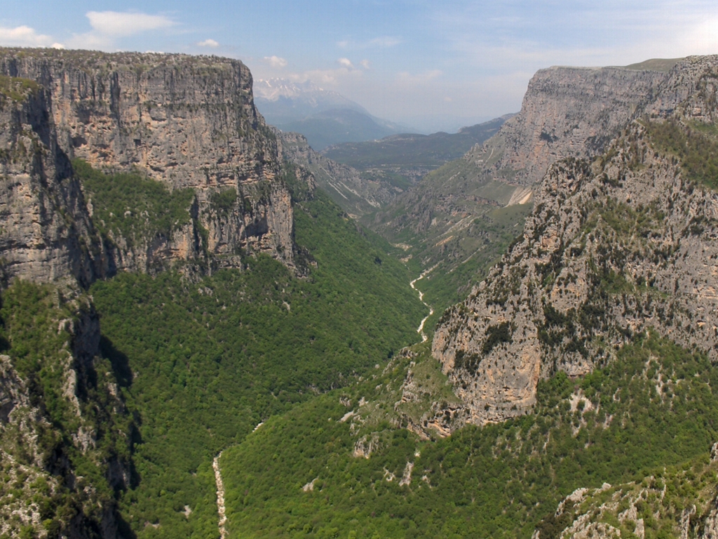
Koukouli () is a village of the Zagori region, in the municipal unit of Tymfi, in northwestern Greece. The village is situated at the southern end of the Vikos Gorge. History The village takes its name from the Greek word of silkworm cocoon; silk production in the wider region of Zagori was popular during the past centuries. The village appears to be founded somewhere in the 13th century. It was included in the treaty signed between the villages of Zagori (there were 14 at the time) and the Ottomans at 1430, which marked the beginning of Ottoman rule in the region. The villages of Zagori formed an autonomous federation for the next centuries. The privileges which were granted to the federation of Zagori and which are due, in the biggest part, to the influence of notable Zagorians over the Sublime Porte, were preserved until 1868. According to these privileges, Zagori was autonomous and self-governed under the surveillance of the Vekili of Zagori. Many inhabitants during the 1 ... [...More Info...] [...Related Items...] OR: [Wikipedia] [Google] [Baidu] |
Kipoi, Ioannina
Kipoi (, before 1928: Μπάγια – ''Bagia'') is a village in the region of Zagori. It belongs to the municipal unit of Tymfi (municipal unit), Tymfi, Ioannina (regional unit), Ioannina regional unit, Greece. The Greek name derives from the many gardens in the surrounding areas (Greek Κήποι=Gardens). The name "Bagia" is Slavic and means "warm (and low) place".A.Kathareios (Inspector of the 1st educational region of Epirus) ''Report of Inspection of Zagorohoria in 1913'' The village has the lowest altitude of all Zagori village and is surrounded by rivers. It is built on a rocky hill, in the southern end of Vikos Gorge. History and culture Kipoi was once the centre of Zagori. After the Balkan Wars and the liberation of Epirus in 1913, the people of Kipi demanded that Kipoi becomes the capital of Zagori, because it is the most central village and because it once was the "capital". In Kipoi, the traditional architectural style of Epirus is well preserved, with stone buil ... [...More Info...] [...Related Items...] OR: [Wikipedia] [Google] [Baidu] |
Iliochori
Iliochori (, "Village of the Sun", before 1927: Δοβρίνοβο - ''Dovrinovo''; ) is one of the Zagori villages in northwest Greece. It is located in the municipal unit of Tymfi in the northern part of the regional unit of Ioannina. According to a local legend, the village was founded as ''Rasciana'', on the river of the same name. However, that site was abandoned because of a lack of drinking water, and the inhabitants scattered to found Iliochori and the nearby town of Laista (ancient Lisinitza). Iliochori was traditionally an agricultural village, with husbandry and cultivation of barley and vetch being among its primary areas of economic activity. Viticulture was also prominent, and the village produced a wine, Dobrovino, that gave it its original name. Caravans leaving from Iliochori carried products from the region to the Balkans for trade. The town suffered severe damage in both World War II and the Greek Civil War and lost a large portion of its population during the ... [...More Info...] [...Related Items...] OR: [Wikipedia] [Google] [Baidu] |
Ioannina (regional Unit)
Ioannina () is one of the regional units of Greece, located in the northwestern part of the country. It is part of the region of Epirus (region), Epirus. Its capital is the city of Ioannina. It is the largest regional unit in Epirus, and one of the largest regional units of Greece, with a population of 160,773 people, according to the 2021 census. Geography Ioannina borders Albania in the north, and the regional units of Kastoria (regional unit), Kastoria in the northeast, Grevena (regional unit), Grevena and Trikala (regional unit), Trikala in the east, Arta (regional unit), Arta in the southeast, Preveza (regional unit), Preveza in the south and Thesprotia in the southwest and west. Ioannina is a mountainous region, dominated by the Pindus mountains, that cover the eastern part of the regional unit. The main subranges of the Pindus are from north to south: Gramos, Smolikas (2,637 m, the highest of the Pindus), Tymfi, Lygkos, Lakmos and Athamanika. The lower Xerovouni mountains ... [...More Info...] [...Related Items...] OR: [Wikipedia] [Google] [Baidu] |
Vrysochori
Vrysochori (, before 1927: Λεσινίτσα - ''Lesinitsa'', ) is one of the Zagori Aromanian ( Vlach) villages (Zagorochoria), in the Ioannina regional unit, Greece. Vrysochori is in the Tymfi municipal unit, and is about 75 km (50 mi) from Ioannina. Location and climate The elevation of Vrysochori is 1157 m (3799 ft) above sea-level. Vrysochori is surrounded by conifer forests and rivers at the foothills of ''Gamila'' of the Tymphis mountain range, and borders the Vikos–Aoös National Park. Vrysochori is the 3rd largest village of Zagori Villages in terms of land size. The village is located in between the second and the fifth highest peaks of Greece, just 5 km away from the Aoos River. It is the only area of Greece where snowbanks stand throughout every season of the year. The forest area which belongs to the village is the 2nd biggest in Zagori (after Laista) and local forest maps are required for trekkers not to be lost in them ... [...More Info...] [...Related Items...] OR: [Wikipedia] [Google] [Baidu] |
Vradeto
Vradeto () is a village in the Greek Zagori region ( Epirus region). It lies at a height of on Mt Tymphe in the Pindus mountain range. It is the highest of the 44 villages of Zagori. It is the middle of the Vikos–Aoös National Park and is about away from Ioannina. It is located only a few kilometers from the Vikos Gorge and near one of the best vantage points, Beloe (Beloi) (perhaps a Slavic word meaning "good view" or "balcony"). It is located also close to an alpine lake called Drakolimni (''Dragon's Lake''), one of several such lakes. The lakes are named after the amphibian newts ('' Ichthyosaura alpestris'') that live in them, around which there are myths of dragons. The myths are echoes of ancient myths about the hero Pindus, son of Macedon, who either befriended or according to another myth killed a dragon. Nearest places * Tsepelovo, east (distance: ) * Kapesovo, south (distance: ) Population History Until the close of the 20th century there was only one way to r ... [...More Info...] [...Related Items...] OR: [Wikipedia] [Google] [Baidu] |


