|
Todke Waterfall
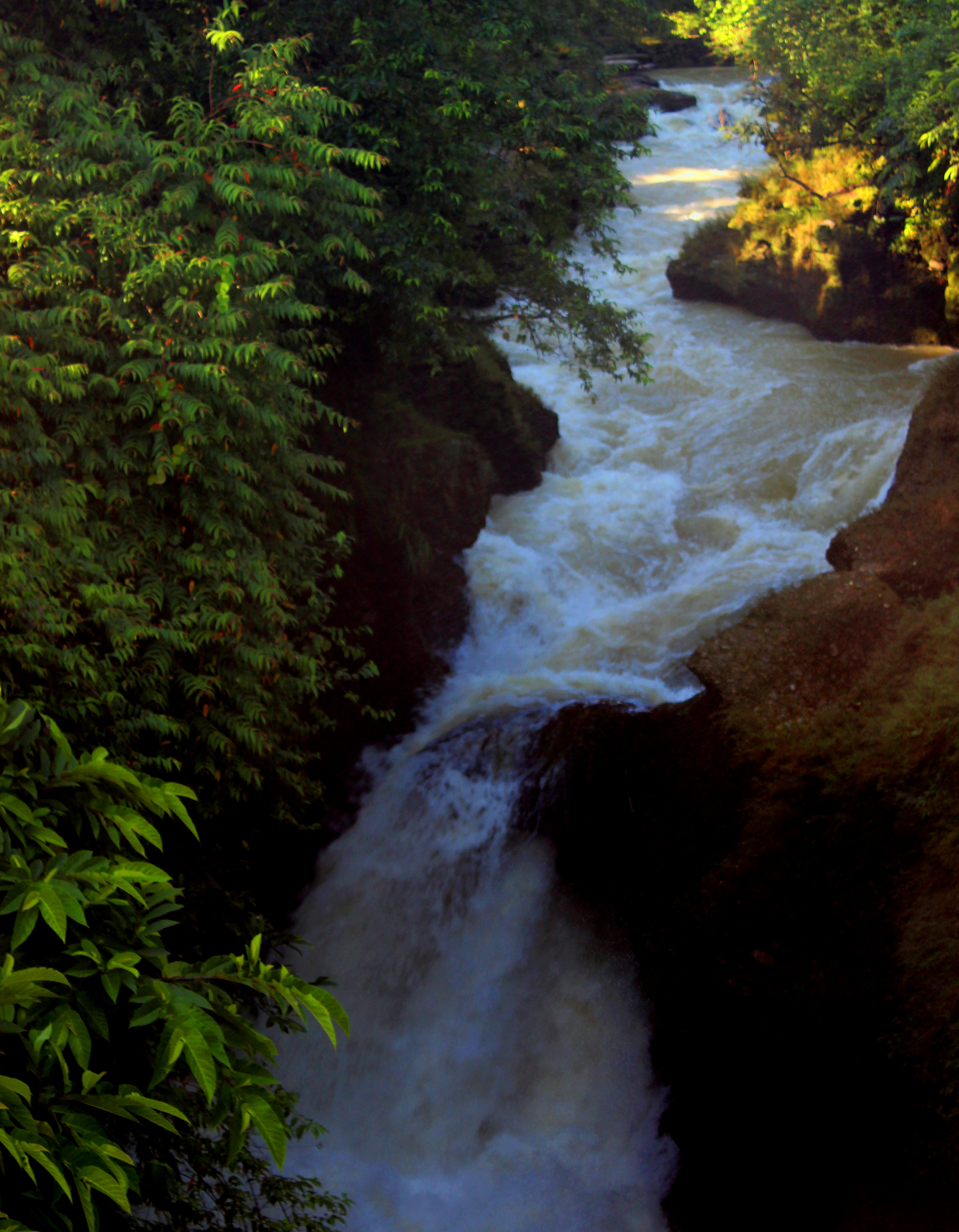
Todke waterfall (Nepali: टोड्के झरना) is located in the hills of Maimajhuwa near Mai Pokhari in Ilam district. The fall feeds the Mai River. It has a height of 85 m. The fall is accessible by trekking from the district headquarter. The local government is initiating to increase tourism in the area by developing roads and lodging facilities near the waterfall. Gallery Todke bridgre.jpg Todke falls 11.jpg Todke falls 13.jpg Todke falls 17.jpg Todke falls 18.jpg See also *List of waterfalls *List of waterfalls of Nepal This is a list of waterfalls in Nepal. They are also called Jharana(Nepali-झरना) in local language. List See also * List of waterfalls References {{Asia topic, List of waterfalls in Waterfalls of Nepal, * Lists of waterfalls by ... References Waterfalls of Nepal Ilam District {{IlamNP-geo-stub ... [...More Info...] [...Related Items...] OR: [Wikipedia] [Google] [Baidu] |
Ilam District
Ilam district () is one of Districts of Province No. 1, 14 districts of Koshi Province of eastern Nepal. It is a Geography of Nepal#The Hill Region, Hill districts of Nepal, district and covers . The 2011 Nepal census, 2011 census counted 290,254 inhabitants. The municipality of Ilam, Nepal, Ilam is the district headquarters and is about from Kathmandu. Ilam attracts many researchers and scientists for the study of medicinal and aromatic plants, orchids, rare birds and the red panda. Ilam stretches from the Terai belt to the upper hilly belt of this Himalayan nation. Etymology The name ''Ilam'' is derived from the Limbu language in which "IL" means twisted and "Lam" means road. Ilam was one of the ten self ruling states of Limbuwan before the reunification of Nepal. Its ruler, King Hangshu Phuba Lingdom of Lingdom dynasty, ruled Ilam as a confederate state of Limbuwan until 1813 AD. The treaty between the other Limbuwan states and the King of Gorkha (Gorkha-Limbuwan Treaty o ... [...More Info...] [...Related Items...] OR: [Wikipedia] [Google] [Baidu] |
Mai River
The Mai Khola is a river in eastern Nepal, the headwater of the Kankai River. Its water is used for irrigation and also powers several hydroelectric plants. Location The Mai Khola is the main tributary of the Kankai. It is a perennial river that originates in springs in the Mahabharat Range about above sea level. It flows from north to south. Major tributaries include the Jog Mai Khola and the Puwa Khola. At its confluence with the Deb Mai Khola, it takes the name of Kankai Mai River, and when it enters the Jhapa District it becomes the Kankai River. The catchment area of the Mai Khola upstream from the Kankai Mai River at Chepte is , and lies entirely within the Ilam District. Mai AWP The Mai Area Water Partnership (AWP) was established after a June 2002 workshop. It is a network of local water-related institutions with the Namsaling Community Development Centre (NCDC), a non-governmental organization, as the host institution. The purpose was to ensure sustainable irrigation ... [...More Info...] [...Related Items...] OR: [Wikipedia] [Google] [Baidu] |
Maimajhuwa
Maimajhuwa is a town and Village Development Committee in Ilam District in the Province No. 1 of eastern Nepal. At the time of the 1991 Nepal census The 1991 Nepal census was a widespread national census conducted by the Nepal Central Bureau of Statistics. Working with Nepal's Village Development Committees at a district level, they recorded data from all the main towns and villages of each ... it had a population of 3,543 persons living in 578 individual households. References External linksUN map of the municipalities of Ilam District Populated places in Ilam District {{IlamNP-geo-stub ... [...More Info...] [...Related Items...] OR: [Wikipedia] [Google] [Baidu] |
Mai Pokhari
Mai Pokhari is a wetland in Ilam District of Nepal that was designated a Ramsar site on 28 October 2008. It is a pilgrimage center for both Hindus and Buddhists. The lake within the wetland which reflects emerald waters has a circumference of about and boats are operated. On the periphery of the lake there is the Maipokhari Botanical Garden of horticultural and ecological importance which houses a rock garden, an orchid house, plants collected from many regions of eastern Nepal, and a green house. Geography The wetland is in the middle hill ranges of the Himalayas at an elevation of about and covers an area of . It is about to the north of Ilam. The wetland has been created due to ground subsidence. The source of water in the wetland is from natural springs and precipitation. It is the main source of fresh water for local people. Flora and fauna The wetland's flora consists of ''Schima'', ''Castanopsis'', laurel oak (''Quercus laurifolia'') and epiphytic orchids. Water lil ... [...More Info...] [...Related Items...] OR: [Wikipedia] [Google] [Baidu] |
List Of Waterfalls
This list of notable waterfalls of the world is sorted by continent, then country, then province, state or territory. A waterfall is included if it is at least tall and has an existing Wikipedia article, or it is considered historically significant based on multiple reliable references. There is no standard way to measure the height or width of a waterfall. No ranking of waterfalls should be assumed because of the heights or widths provided in the list. Many numbers are estimated and measurements may be imprecise. See additional lists of waterfalls by List of waterfalls by height, height, List of waterfalls by flow rate, flow rate and List of waterfalls by type, type. Africa Angola * Kalandula Falls – high Burundi * Kagera waterfalls, Kagera Falls * Rusumo Falls Central African Republic * Boali, Boali Falls Chad * Gauthiot Falls Democratic Republic of the Congo * Boyoma Falls – formerly known as Stanley Falls; highest flow rate in the world * Inga ... [...More Info...] [...Related Items...] OR: [Wikipedia] [Google] [Baidu] |
List Of Waterfalls Of Nepal
This is a list of waterfalls in Nepal. They are also called Jharana(Nepali-झरना) in local language. List See also * List of waterfalls References {{Asia topic, List of waterfalls in Waterfalls of Nepal, * Lists of waterfalls by country, Nepal Lists of landforms of Nepal, Waterfalls ... [...More Info...] [...Related Items...] OR: [Wikipedia] [Google] [Baidu] |
Waterfalls Of Nepal
A waterfall is any point in a river or stream where water flows over a vertical drop or a series of steep drops. Waterfalls also occur where meltwater drops over the edge of a tabular iceberg An iceberg is a piece of fresh water ice more than long that has broken off a glacier or an ice shelf and is floating freely in open water. Smaller chunks of floating glacially derived ice are called "growlers" or "bergy bits". Much of an i ... or ice shelf. Waterfalls can be formed in several ways, but the most common method of formation is that a river courses over a top layer of resistant bedrock before falling onto softer rock, which Erosion, erodes faster, leading to an increasingly high fall. Waterfalls have been studied for their impact on species living in and around them. Humans have had a distinct relationship with waterfalls since prehistory, travelling to see them, exploring and naming them. They can present head of navigation, formidable barriers to navigation along ... [...More Info...] [...Related Items...] OR: [Wikipedia] [Google] [Baidu] |


