|
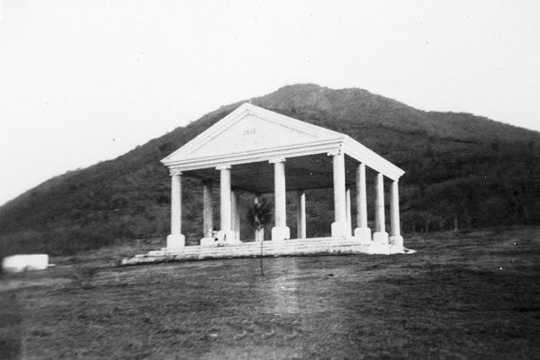
Temple Of Minerva (Guatemala)
The Temple of Minerva was a Greek style temple erected in Guatemala City by the government of president Manuel Estrada Cabrera in 1901 to celebrate the Fiestas Minervalias. Soon, the main cities in the rest of Guatemala built similar structures as well. Temples built in the Republic Several Temples of Minerva were built across Guatemala, and a few of them still stand: See also * Manuel Estrada Cabrera Manuel José Estrada Cabrera (21 November 1857 – 24 September 1924) was the President of Guatemala from 1898 to 1920. A lawyer with no military background, he was a strong ruler (dictator) who modernised the country's industry and transportat ... Notes and references Notes References Bibliography * * * * * * * * External links {{coord, 14.6228, N, 90.5314, W, source:wikidata, display=title Manuel Estrada Cabrera History of Guatemala ... [...More Info...] [...Related Items...] OR: [Wikipedia] [Google] [Baidu] |
Guatemala City
Guatemala City ( es, Ciudad de Guatemala), known locally as Guatemala or Guate, is the capital and largest city of Guatemala, and the most populous urban area in Central America. The city is located in the south-central part of the country, nestled in a mountain valley called Valle de la Ermita ( en, Hermitage Valley). The city is the capital of the Municipality of Guatemala and of the Guatemala Department. Guatemala City is the site of the Mayan city of Kaminaljuyu, founded around 1500 BC. Following the Spanish conquest, a new town was established, and in 1776 it was made capital of the Kingdom of Guatemala. In 1821, Guatemala City was the scene of the declaration of independence of Central America from Spain, after which it became the capital of the newly established United Provinces of Central America (later the Federal Republic of Central America). In 1847, Guatemala declared itself an independent republic, with Guatemala City as its capital. The city was originally ... [...More Info...] [...Related Items...] OR: [Wikipedia] [Google] [Baidu] |
Escuintla Department
Escuintla () is one of the 22 departments of Guatemala. The capital of the department is the city of Escuintla. Escuintla covers an area of 4,384 km² and is situated in the coastal lowland region, directly south of Guatemala City, and bordered by the Pacific Ocean. Escuintla produces about 43 percent of gross domestic product of Guatemala. Municipalities # Escuintla # Guanagazapa # Iztapa # La Democracia # La Gomera # Masagua # Nueva Concepción # Palín # San José # San Vicente Pacaya # Santa Lucía Cotzumalguapa # Sipacate # Siquinalá # Tiquisate Tiquisate () is a town, with a population of 29,193 (2018 census), and a municipality in the Escuintla department of Guatemala Guatemala ( ; ), officially the Republic of Guatemala ( es, República de Guatemala, links=no), is a country i ... Museums * Museo Regional de Arqueología de la Democracia Notes External linksInteractive department map {{Authority control Departments of Guatemala ... [...More Info...] [...Related Items...] OR: [Wikipedia] [Google] [Baidu] |
Diario De Centro América
The ''Diario de Centro América'' is the newspaper of public record in Guatemala. Founded in 1880, it is the official newspaper of the country's government. References * * * External links *''Diario de Centro América'' Newspapers published in Guatemala {{Guatemala-stub ... [...More Info...] [...Related Items...] OR: [Wikipedia] [Google] [Baidu] |
Sacatepéquez
Sacatepéquez () was a city in Guatemala from November 21, 1542 until July 29, 1773 when it was destroyed by the Santa Marta earthquake. Sacatepéquez means ''grasshill'' and gave its name to the Sacatepéquez Department. Sacatepéquez and Antigua Guatemala were the two municipalities belonging to the department of Chimaltenango. On September 12, 1839, the department of Sacatepéquez was created, getting its name from the former city. Antigua Guatemala was made the capital. See also Chajoma The Chajoma () were a Kaqchikel-speaking Maya people of the Late Postclassic period, with a large kingdom in the highlands of Guatemala. According to the indigenous chronicles of the K'iche' and the Kaqchikel, there were three principal Postclas ... Populated places established in 1542 Municipalities of the Sacatepéquez Department History of Guatemala Destroyed cities 1542 establishments in the Spanish Empire {{Guatemala-hist-stub ... [...More Info...] [...Related Items...] OR: [Wikipedia] [Google] [Baidu] |
Quetzaltenango Department
Quetzaltenango is a department in the western highlands of Guatemala. The capital is the city of Quetzaltenango, the second largest city in Guatemala.Rouanet et al 1992, p.14. The department is divided up into 24 municipalities. The inhabitants include Spanish-speaking Ladinos and the K'iche' and Mam Maya groups, both with their own Maya language. The department consists of mountainous terrain, with its principal river being the Samalá River. the department is seismically active, suffering from both earthquakes and volcanic activity. Prior to the Spanish conquest the territory included in the modern department formed a part of the K'iche' Kingdom of Q'umarkaj. The kingdom was defeated by the Spanish under Pedro de Alvarado in a number of decisive battles fought near the city of Quetzaltenango, then known as Xelaju. In the 19th century the territory of the modern department was included in the short-lived Central American state of Los Altos. The department was created by decree ... [...More Info...] [...Related Items...] OR: [Wikipedia] [Google] [Baidu] |
Jalapa Department
Jalapa is a department of Guatemala, in the south east-of the republic. The capital is the city of Jalapa. In 2018 the department of Jalapa had a population of 342,923. The majority is ladino, of predominantly European descent, with sizeable minorities of K'iche' and Poqomam Maya. The main agricultural products are cattle, sorghum, tobacco, onion and maize. Municipalities # Jalapa Xalapa or Jalapa (, ), officially Xalapa-Enríquez (), is the capital city of the Mexican state of Veracruz and the name of the surrounding municipality. In the 2005 census the city reported a population of 387,879 and the municipality of which ... # Mataquescuintla # Monjas # San Carlos Alzatate # San Luis Jilotepeque # San Manuel Chaparrón # San Pedro Pinula Volcanoes * Volcán Jumay References External links all the information about Jalapa [...More Info...] [...Related Items...] OR: [Wikipedia] [Google] [Baidu] |
Huehuetenango Department
Huehuetenango is one of the 22 departments of Guatemala. It is situated in the western highlands and shares borders with the Mexican state of Chiapas in the north and west; with El Quiché in the east, with Totonicapán, Quetzaltenango and San Marcos to the south. The capital is the city of Huehuetenango.ITMB 2005. Huehuetenango's ethnic composition is one of the most diverse in Guatemala. While the Mam are predominant in the department, other Maya groups are the Q'anjob'al, Chuj, Jakaltek, Tektik, Awakatek, Chalchitek, Akatek and K'iche'. Each of these nine Maya ethnic groups speaks its own language. Name The department of Huehuetenango takes its name from the city of the same name which serves as the departmental capital. The name is derived from the Nahuatl language of central Mexico, given by the indigenous allies of the Spanish conquistadors during the Spanish Conquest of Guatemala. It is usually said to mean "place of the elders" but may be a corruption of ... [...More Info...] [...Related Items...] OR: [Wikipedia] [Google] [Baidu] |


