|
States Of The Federated States Of Micronesia
These states are the administrative divisions of the Federated States of Micronesia The Federated States of Micronesia is a federation A federation (also called a federal state) is an entity characterized by a political union, union of partially federated state, self-governing provinces, states, or other regions under a ...: References {{reflist States, Micronesia, Federated States of Federated States of Micronesia geography-related lists ... [...More Info...] [...Related Items...] OR: [Wikipedia] [Google] [Baidu] |
Administrative Divisions Of The Federated States Of Micronesia
The Federated States of Micronesia is a federation A federation (also called a federal state) is an entity characterized by a political union, union of partially federated state, self-governing provinces, states, or other regions under a #Federal governments, federal government (federalism) ... divided into four states, which are further divided into various cities and municipalities. States Cities and Municipalities ''Cities are written in bold.'' See also * ISO 3166-2:FM References External links * * {{Articles on first-level administrative divisions of Oceanian countries Cities Micronesia, Federated States of Micronesia, Federated States of Federated States of Micronesia geography-related lists ... [...More Info...] [...Related Items...] OR: [Wikipedia] [Google] [Baidu] |
Chuuk State
Chuuk State (; also known as Truk) is one of the four states of the Federated States of Micronesia (FSM). It consists of several island groups: Nomoneas, Faichuk, Faichuuk, the Hall Islands, Namonuito Atoll (Magur Islands), Pattiw (Western Islands), and the Nomoi Islands, Mortlock Islands. Chuuk is by far the FSM's most populous state, with 50,000 inhabitants on . Chuuk Lagoon is where most people live. Weno island, in the lagoon, is Chuuk's state capital and the country's biggest city. It may Proposed Chuukese independence referendum, hold a referendum on independence in the near future, although this referendum has been repeatedly postponed. History Indigenous settlement Chuuk was first settled by Austronesian peoples, Austronesians, believed to be from the Lapita culture of Island Melanesia. Archaeological evidence indicates that islands of Fefan, Feefen and Wééné Islands had human settlements in the second and first century BCE. Later evidence indicates that widespread ... [...More Info...] [...Related Items...] OR: [Wikipedia] [Google] [Baidu] |
Weno
Weno, formerly Moen, is an island municipality of Chuuk State of the Federated States of Micronesia (FSM). It is the largest town in the FSM and the capital of Chuuk. It has an estimated area of 20 square kilometers. Population The population was 13,856 at the census taken in 2010. Geography It is located in the Chuuk Lagoon. Its villages are on the coast (Sapuk, Penia, Peniesene, Tunnuk, Mechitiw, Iras, Nantaku, Nepukos, Mwan, Neiwe, and Wichap, Epinup) and serve as the center of commerce. Weno is the state capital and the second-most populous island of the FSM (if the complex of Tol/Wonei, Polle and Patta is counted as one island), with a population of 13,856 at the 2010 census. The highest point is Mount Teroken, elevation 364 m (1,214 ft). Transportation Weno has the only airport in the state, Chuuk International Airport. The road system is not well established in some parts of the island. No public transportation exists, but visitors can use a small taxi ... [...More Info...] [...Related Items...] OR: [Wikipedia] [Google] [Baidu] |
Kosrae
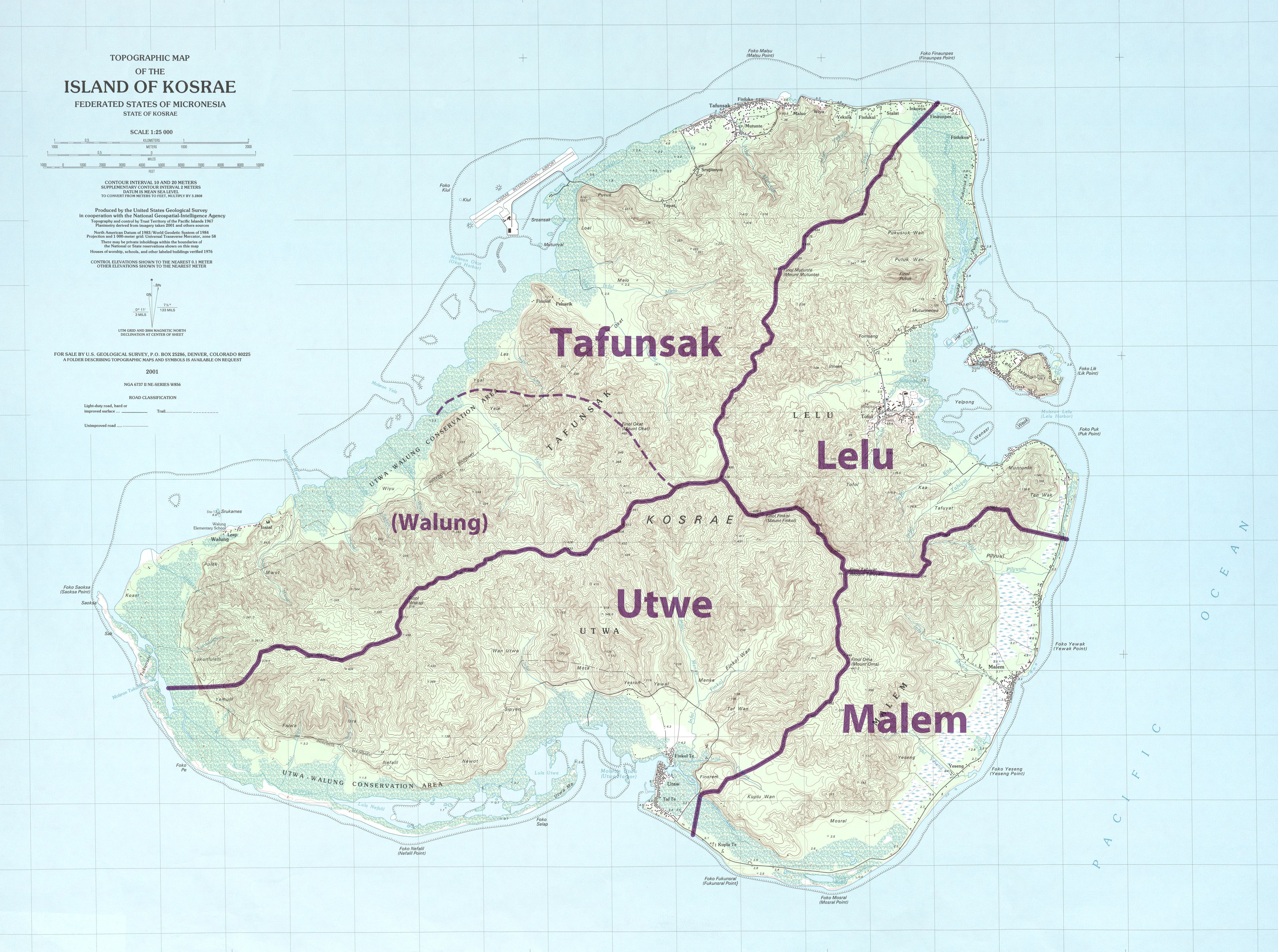
Kosrae ( ), formerly known as Kusaie or Strong's Island, is an island in the Caroline Islands archipelago, and States of Micronesia, state within the Federated States of Micronesia. It includes the main island of Kosrae, traditionally known as Ualung (which means the "high island"), and a few intercoastal islands and islets, the most significant of which (Lelu Island) is inhabited by 1,500 people. Kosrae's land area is , making it the smallest state by area. Sustaining 6,600 people, it is also the smallest by population. Tofol is the state capital, and Mount Finkol is the highest point at . History Archaeological evidence shows that the island was settled at least by the early years of the first millennium AD. This includes the city of Leluh archaeological site, Leluh that existed from about 1250 to 1850 AD, and in its heyday had a population of about 1,500 and covered some . It featured burial pyramids for the nobility. French visitors The French corvette (ship), corvette ... [...More Info...] [...Related Items...] OR: [Wikipedia] [Google] [Baidu] |
Tofol
Tofol village in Lelu Town municipality is the seat of government of the States of the Federated States of Micronesia, state of Kosrae in Federated States of Micronesia, Micronesia, according to the provisions of the Kosrae State Code, Title 2, Chap. 2. It is the most easterly point of Micronesia. Location Tofol is in Lelu, Micronesia, Lelu municipality, located almost directly southwest of Lelu Island. Education Kosrae State Department of Education operates public schools: * Kosrae High SchoolKosrae High School " Kosrae State Department of Education. Retrieved on February 23, 2018. "The school is located in the center of the island in Tofol." References Municipalities of Kosrae {{micronesia-geo-stub ...[...More Info...] [...Related Items...] OR: [Wikipedia] [Google] [Baidu] |
Kolonia
Kolonia is a coastal town and the capital of Pohnpei State in the Federated States of Micronesia (FSM). It's not to be confused with the far smaller Colonia, the capital of the State of Yap. It was also the former FSM capital before being replaced by Palikir in 1989, located nearby to the southwest in the municipality of Sokehs. It has 6,074 people. Description Kolonia Town is located in the north central section of Pohnpei Island. It was formerly part of Nett municipality but has been a separate municipality since May 1965. The population of the town was 6,074 (2010 Census). It is the largest population center on Pohnpei and the commercial hub of the island. The land area of Kolonia amounts to 1.5 km2, with a large number of buildings lying just outside the town limits. The official languages are Pohnpeian and English. Mercedarian Missionaries speak Spanish. History Kolonia's history is deeply marked by Pohnpei's multiple foreign occupiers, and evidence of their ... [...More Info...] [...Related Items...] OR: [Wikipedia] [Google] [Baidu] |
Yap State
Yap State ( or ) is one of the four states of the Federated States of Micronesia, located in the westernmost portion of the country. The state borders Palau to the southwest, Guam to the north, and Chuuk State to the east. According to the state's population census carried out in 2020, the total population is 11,577 residing across a total area of 119.54 sq km (46.15 sq mi), though a large majority of the area is water. The only town area in the state, Colonia, serves as the state capital. What is now current-day Yap State and some parts of Chuuk State were the historical Yapese Empire, which at its peak, controlled 1,300 km of the western Pacific comprising all the inhabited islands and atolls between Yap and Chuuk. The rulers of the chiefdom of Gagil in Yap maintained sovereignty of these islands to the east and extracted resources and tribute, maintaining close economic and political relationships with the different island groups. After losing its influence and becoming inc ... [...More Info...] [...Related Items...] OR: [Wikipedia] [Google] [Baidu] |
Colonia, Yap
Colonia is an urban area between the municipalities of Rull and Weloy which serves as the capital of Yap State, one of the states in the Federated States of Micronesia. It’s not to be confused with Kolonia, the capital of Pohnpei State. It administers both Yap proper and some 13 atolls and islands reaching to the east and south for some . The 2010 Census population was 3,126. A Spanish Catholic mission was established in Colonia in 1885, during Yap's time as a colony of Spain. Tamil Harbor is the main port of Yap State. Ships have to travel through a reef-bordered passageway to reach the port, where there is a small craft wharf. There are various hotels, restaurants, shops and a medical store as well as a hospital and banks in Colonia. Yap is famous for its Rai stones, traditional money made of limestone, which was brought from neighbouring islands in Palau. Many rai stones are now placed in front of meetinghouses and around village courts. Many are kept along pathways ... [...More Info...] [...Related Items...] OR: [Wikipedia] [Google] [Baidu] |
States Of The Federated States Of Micronesia
These states are the administrative divisions of the Federated States of Micronesia The Federated States of Micronesia is a federation A federation (also called a federal state) is an entity characterized by a political union, union of partially federated state, self-governing provinces, states, or other regions under a ...: References {{reflist States, Micronesia, Federated States of Federated States of Micronesia geography-related lists ... [...More Info...] [...Related Items...] OR: [Wikipedia] [Google] [Baidu] |


