|
Sigmaringen
Sigmaringen ( Swabian: ''Semmerenga'') is a town in southern Germany, in the state of Baden-Württemberg. Situated on the upper Danube, it is the capital of the Sigmaringen district. Sigmaringen is renowned for its castle, Schloss Sigmaringen, which was the seat of the principality of Hohenzollern-Sigmaringen until 1850 and is still owned by the Hohenzollern family. Geography Surrounded by wooded hills Sigmaringen lies in the Danube valley, south of the Swabian Alps and around 40 km north of Lake Constance. The surrounding towns are Winterlingen (in the district of Zollernalb) and Veringenstadt in the north, Bingen, Sigmaringendorf, and Scheer in the east, Mengen, Krauchenwies, Inzigkofen, and Meßkirch in the south, and Leibertingen, Beuron, and Stetten am kalten Markt in the west. The town is made up of the following districts: Sigmaringen town center, Gutenstein, Jungnau, Laiz, Oberschmeien, and Unterschmeien. Climate Sigmaringen's climate is classified ... [...More Info...] [...Related Items...] OR: [Wikipedia] [Google] [Baidu] |
Sigmaringen Castle
Sigmaringen Castle () was the princely castle and seat of government for the Princes of Hohenzollern-Sigmaringen. Situated in the Swabian ''Alb'' region of Baden-Württemberg, Germany, this castle dominates the skyline of the town of Sigmaringen. The castle was rebuilt following a fire in 1893, and only the towers of the earlier medieval fortress remain. Schloss Sigmaringen was a family estate of the Swabian Hohenzollern family, a cadet branch of the Hohenzollern family, from which the German Emperors and kings of Prussia came. During the closing months of World War II, Schloss Sigmaringen was briefly the seat of the Vichy French Government after France was liberated by the Allies. The castle and museums may be visited throughout the year, but only on guided tours. It is still owned by the Hohenzollern-Sigmaringen family, although they no longer reside there. Location Sigmaringen is located on the southern edge of the Swabian Jura, a plateau region in southern Baden-W� ... [...More Info...] [...Related Items...] OR: [Wikipedia] [Google] [Baidu] |
Hohenzollern
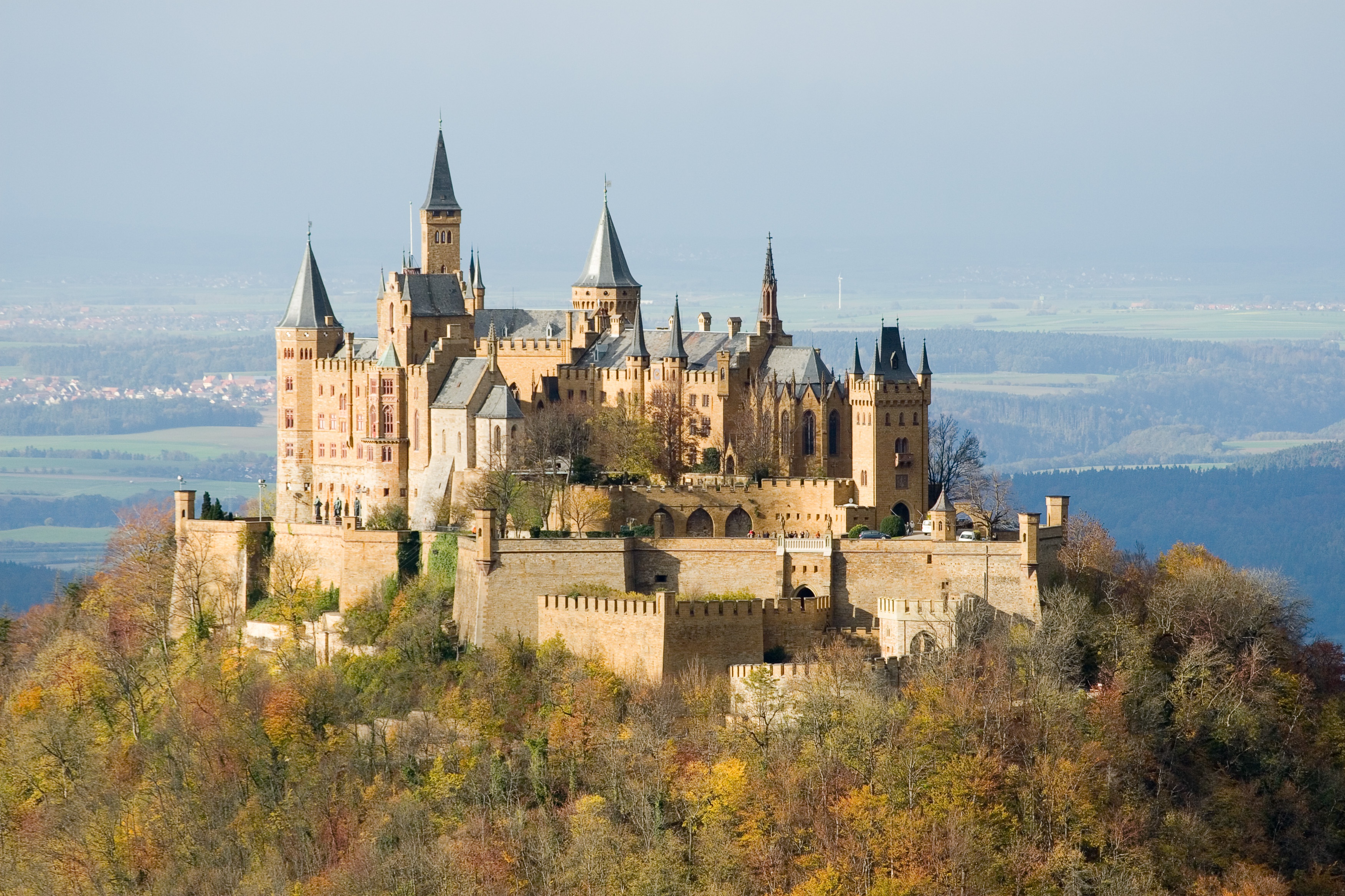
The House of Hohenzollern (, ; , ; ) is a formerly royal (and from 1871 to 1918, imperial) German dynasty whose members were variously princes, electors, kings and emperors of Hohenzollern, Brandenburg, Prussia, the German Empire, and Romania. The family came from the area around the town of Hechingen in Swabia during the late 11th century and took their name from Hohenzollern Castle. The first ancestors of the Hohenzollerns were mentioned in 1061. The Hohenzollern family split into two branches, the Catholic Swabian branch and the Protestant Franconian branch,''Genealogisches Handbuch des Adels, Fürstliche Häuser'' XIX. "Haus Hohenzollern". C.A. Starke Verlag, 2011, pp. 30–33. . which ruled the Burgraviate of Nuremberg and later became the Brandenburg-Prussian branch. The Swabian branch ruled the principalities of Hohenzollern-Hechingen and Hohenzollern-Sigmaringen until 1849, and also ruled Romania from 1866 to 1947. Members of the Franconian branch became Margrave of ... [...More Info...] [...Related Items...] OR: [Wikipedia] [Google] [Baidu] |
Hohenzollern-Sigmaringen
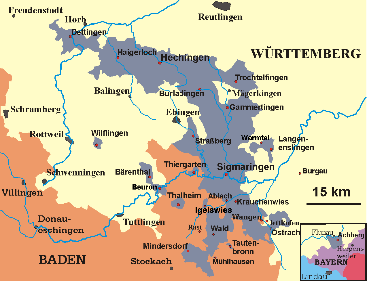
Hohenzollern-Sigmaringen () was a principality in southwestern Germany. Its rulers belonged to the junior House of Hohenzollern#Swabian branch, Swabian branch of the House of Hohenzollern. The Swabian Hohenzollerns were elevated to princes in 1623. The small sovereign state with the capital city of Sigmaringen was Annexation, annexed to the Kingdom of Prussia in 1850 following the abdication of its sovereign in the wake of the revolutions of 1848, then became part of the newly created Province of Hohenzollern. History The junior Swabia, Swabian branch is less well known to history than the senior Burgraviate of Nuremberg#List of burgraves, Franconian line, the latter of which became Burgraviate of Nuremberg, Burgraves of Nuremberg and later ruled Margraviate of Brandenburg, Brandenburg and Prussia, and the German Empire. The County of Hohenzollern-Sigmaringen was created in 1576, upon the partition of the House of Hohenzollern#County of Zollern, County of Hohenzollern, a fief of ... [...More Info...] [...Related Items...] OR: [Wikipedia] [Google] [Baidu] |
Sigmaringen (district)
Sigmaringen is a ''Landkreis'' (district) in the south of Baden-Württemberg, Germany. Neighboring districts are (from north clockwise) Reutlingen, Biberach, Ravensburg, Bodensee, Constance, Tuttlingen, and Zollernalbkreis. History The area of the district was owned by several different states historically. It was split between many minor rulers before the German Mediatisation of the late 18th and early 19th centuries. By 1806 it had become a border area between the Grand Duchy of Baden, the Kingdom of Württemberg, and the much smaller principality of Hohenzollern-Sigmaringen embedded between them. In 1849 Hohenzollern-Sigmaringen became part of the Prussian Province of Hohenzollern (along with the principality of Hohenzollern-Hechingen). At that time it had the of Sigmaringen and Gammertingen, which were merged into the of Sigmaringen in 1925. After WWII it became part of the French-controlled state of Württemberg-Hohenzollern until 1952 when it became part of the moder ... [...More Info...] [...Related Items...] OR: [Wikipedia] [Google] [Baidu] |
Veringenstadt
Veringenstadt ( Swabian: ''Verenga'') is a town in the district of Sigmaringen, in Baden-Württemberg, Germany. It is situated 10 km north of Sigmaringen. Geographical location Veringenstadt is situated in the valley of the Lauchert, a tributary of the Danube, between Gammertingen and Sigmaringen. The municipality area is 3125 hectares.Ignaz Stösser (ist): ''Zahlen und Fakten.'' In: Ders.: ''Wir in Veringen.'' In: ''Schwäbische Zeitung.'' vom 15. Januar 2011. Geology The municipality Veringenstadt lies on the Lauchertgraben (Lauchert trench). East of Veringendorf a petrified sponge reef can be seen, which was created 140 million years ago.''Von Neandertalern und Bohnerzgruben.'' In: ''Wanderbar …die schönsten Routen. Erlebnis Kreis Sigmaringen.'' Landratsamt Sigmaringen, Druckerei Schönebeck, Meßkirch 2004, S. 5–7. History The area of the present municipality Veringenstadt was already settled in early historical times. The town itself is an ancient settle ... [...More Info...] [...Related Items...] OR: [Wikipedia] [Google] [Baidu] |
Sigmaringendorf
Sigmaringendorf ( Swabian: ''Semmerengadorf'') is a small town in the district of Sigmaringen in Baden-Württemberg in Germany. In Sigmaringendorf the small river ''Lauchert'' flows into the Danube The Danube ( ; see also #Names and etymology, other names) is the List of rivers of Europe#Longest rivers, second-longest river in Europe, after the Volga in Russia. It flows through Central and Southeastern Europe, from the Black Forest sou .... There is an open-air-theatre in Sigmaringendorf, it's called Waldbühne Sigmaringendorf. Mayors Since September 2018 Phillip Schwaiger is the mayor of Sigmaringendorf. *Alois Henne (1980-2018) *Wilhelm Siebenrock (1946–1953) *Alois Maucher (1953–1980) References Sigmaringen (district) Populated places on the Danube {{Sigmaringen-geo-stub ... [...More Info...] [...Related Items...] OR: [Wikipedia] [Google] [Baidu] |
Province Of Hohenzollern
The Province of Hohenzollern (, ''Hohenzollern Lands'') was a district of Prussia from 1850 to 1946. It was located in Swabia, the region of southern Germany that was the ancestral home of the House of Hohenzollern, to which the kings of Prussia belonged. The Hohenzollern Lands were formed in 1850 from two principalities that had belonged to members of the Catholic branch of the Hohenzollern family. They were united to create a unique type of administrative district (''Regierungsbezirk'') that was not a true province – a was normally a part of a province – but that had almost all the rights of a Prussian province. The Hohenzollern Lands lost their separate identity in 1946 when they were made part of the state of Württemberg-Hohenzollern following World War II. History The Catholic ruling houses of Hohenzollern-Hechingen and Hohenzollern-Sigmaringen had hereditary treaties with Prussia that went back to 1695 and 1707 respectively. During the German Revolutions of 1848� ... [...More Info...] [...Related Items...] OR: [Wikipedia] [Google] [Baidu] |
Krauchenwies
Krauchenwies is a municipality in the district of Sigmaringen in Baden-Württemberg in Germany. Geography Krauchenwies lies about south of Sigmaringen and north of Lake Constance. It is on the ''Oberschwäbischen Barockstraße'' (west route) and on the southern edge of the conservation area of ''Obere Donau''. The Ablach, which originates on the continental divide, flows through town and on to the Danube. The landscape is hilly and wooded, sloping down to the Danube valley. History Krauchenwies is first mentioned in a document from the Reichenau monastery in 1202. The name appeared as ''Cruchinwis'' (meaning "Cruchin meadow"). By 1216, it had its own parish. Later, the Lords of Leiterberg took over the village and sold it at the end of the 13th century to the Habsburgs. In 1595, Charles II bought Krauchenwies, which has been closely tied to the county of Sigmaringen ever since. Because Hohenzollern-Sigmaringen lands became Prussia Prussia (; ; Old Prussian: ''Pr ... [...More Info...] [...Related Items...] OR: [Wikipedia] [Google] [Baidu] |
Leibertingen
Leibertingen is a municipality in the district of Sigmaringen in Baden-Württemberg, Germany. Geography Geographical location Leibertingen is located 600 to 850 meters above sea level directly over the Danube valley in the Heuberg region, a plateau at the southern bound corner of the Swabian Jura, with a distance of 22 km to Sigmaringen and 24 km to Tuttlingen and belongs to the Naturpark Obere Donau. Of the total area of around 4720 hectares (as of Dec. 31 2010Angaben nach Auskunft aus dem Vorzimmer des Bürgermeisters der Gemeinde Leibertingen, vom 12. Januar 2011.), 2127 hectare are forest, 2328 hectare are farmland and 257 hectares consist of residential and circulation areas.http://www.leibertingen.de/ Homepage der Gemeinde The so-called "Dreiländereck" (Eng. border triangle) is located underneath the nearby Wildenstein mountain. This is where Württemberg ( Irndorf parish), Hohenzollern-Sigmaringen (Beuron parish) and Baden Baden (; ) is a histori ... [...More Info...] [...Related Items...] OR: [Wikipedia] [Google] [Baidu] |
Bingen, Baden-Württemberg
Bingen () is a municipality in the district of Sigmaringen in Baden-Württemberg in Germany. Mayors Jochen Fetzer was elected mayor in 2002. He was reelected in October 2010Vera Romeu (vr): ''Bürgermeisterwahl. Die Wahlbeteiligung übertrifft alle Erwartungen''. In: ''Schwäbische Zeitung'' vom 11. Oktober 2010 and 2018. In 2024 Marco Potas was elected mayor. * Robert Daubenberger (CDU) * 1978–2002: Paul Mayer (CDU) * 2003–2024: Jochen Fetzer (independent) * since 2024: Marco Potas (independent) Points of interest * Hornstein Castle Ruin, first noted in 1271, a former Reichsfestung. Between 1818 and 1869 the castle served as an asylum and prison. It was partly demolished in 1879. The castle's chapel is still in good shape and used for religious ceremonies. It contains medieval altars by Magnus Hops. Famous people * Johann Schreck S.J. (* 1576 Bingen, † 1630 Beijing), also known as ''Terrentius Constantiensis, Deng Yuhan Hanpo, Deng Zhen Lohan'', Jesuit, Missionary to ... [...More Info...] [...Related Items...] OR: [Wikipedia] [Google] [Baidu] |
Scheer, Germany
Scheer ( Swabian: ''Schär'') is a town in the district of Sigmaringen, in Baden-Württemberg, Germany. It is situated on the Danube The Danube ( ; see also #Names and etymology, other names) is the List of rivers of Europe#Longest rivers, second-longest river in Europe, after the Volga in Russia. It flows through Central and Southeastern Europe, from the Black Forest sou ..., 6 km east of Sigmaringen. References Sigmaringen (district) Populated places on the Danube {{Sigmaringen-geo-stub ... [...More Info...] [...Related Items...] OR: [Wikipedia] [Google] [Baidu] |


