|
Serbs In Albania
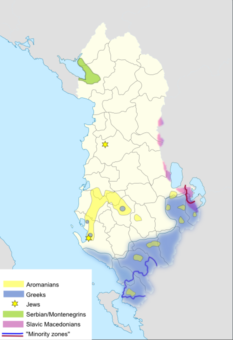
Serbs and Montenegrins (Serbs-Montenegrins) are an ethno-linguistic community in Albania. They are one of the recognized national minorities. The population was concentrated in the region of Vraka, but largely emigrated in the 1990s. The community is bilingual and by majority adhere to Eastern Orthodoxy, while a minority professes Islam. The majority of the Serbo-Montenegrin community came to Albania from Montenegro during the interwar King Zog, Zogist period following 1926 and later from 1938 until 1948. In the latest census (2023), 511 citizens declared themselves as Montenegrins and 586 as Serbs. Terminology The community is commonly known as Serbs-Montenegrins (Montenegrin language, Montenegrin/ sr-Cyrl-Latn, Срби-Црногорци, Srbi-Crnogorci; ), "Serbs" () or "Montenegrins" (). It has also been called the Serbo-Montenegrin minority () by the Council of Europe or simply Serbo-Montenegrins. Demographics In the late 19th and 20th century, of the 600-700 people o ... [...More Info...] [...Related Items...] OR: [Wikipedia] [Google] [Baidu] |
Institute Of Statistics (Albania)
The Institute of Statistics () is an independent public legal entity tasked with producing official statistics in the Republic of Albania. INSTAT is organized at the central level, with regional statistical offices at the local level that operate within its organizational structure, which is approved by a decision of the Assembly, in accordance with the provisions of the legislation in force for independent institutions. Overview The statistical service in the Republic of Albania is carried out by the Institute of Statistics. In 1924, a statistical office was created that kept various economic records at the Ministry of Public Works and Agriculture. The activity of this office was limited to agricultural inventories that included the number of farmers and the type and amount of land use with agricultural and livestock plants, as well as some detailed statistics on industry, trade, export-imports and prices. The statistical service was eventually institutionalized by Decree no. ... [...More Info...] [...Related Items...] OR: [Wikipedia] [Google] [Baidu] |
Grilë
Grilë () is a settlement in the former Gruemirë municipality, Shkodër County, northern Albania. At the 2015 local government reform it became part of the municipality Malësi e Madhe. It is part of the Vraka region, and is inhabited by a minority of Montenegrins Montenegrins (, or ) are a South Slavic ethnic group that share a common ancestry, culture, history, and language, identified with the country of Montenegro. Montenegrins are mostly Orthodox Christians; however, the population also includes ..., who call the village Grilj. History 2010s During the early 2010s linguists Klaus Steinke and Xhelal Ylli seeking to corroborate villages cited in past literature as being Slavic speaking carried out fieldwork in settlements of the area. Grilë in the Shkodër area is one of a number of villages with a Slavophone population that speak a Montenegrin dialect. p. 9. "Am östlichen Ufer des Shkodrasees gibt es heute auf dem Gebiet von Vraka vier Dörfer, in denen ein Teil ... [...More Info...] [...Related Items...] OR: [Wikipedia] [Google] [Baidu] |
Moesia
Moesia (; Latin: ''Moesia''; ) was an ancient region and later Roman province situated in the Balkans south of the Danube River. As a Roman domain Moesia was administered at first by the governor of Noricum as 'Civitates of Moesia and Triballia'. It included most of the territory of modern eastern Serbia, Kosovo, north-eastern Albania, northern parts of North Macedonia (Moesia Superior), Northern Bulgaria, Romanian Dobruja and small parts of Southern Ukraine (Moesia Inferior). Geography In ancient geographical sources, Moesia was bounded to the south by the Haemus (Balkan Mountains) and Scardus (Šar) mountains, to the west by the Drinus (Drina) river, on the north by the Donaris (Danube) and on the east by the Euxine (Black Sea). History The region of Moesia was inhabited chiefly by Thracian, Illyrian, and Thraco-Illyrian peoples. The name of the region comes from Moesi, the Latin name of a Thracian tribe who lived there before the Roman conquest. Parts of Moes ... [...More Info...] [...Related Items...] OR: [Wikipedia] [Google] [Baidu] |
Praevalitana
Praevalitana (also ''Prevalitana'', ''Prevaliana'', ''Praevaliana'' or ''Prevalis'') was a Late Roman province that existed between c. 284 and c. 600. It included parts of present-day Montenegro, Albania, and part of present-day Kosovo. Its capital city was Doclea, later Scodra. Background The Roman Empire conquered the Adriatic-Balkanic region after the Third Illyrian War, in which the Romans defeated Gentius, the last king of Illyria, at Scodra in 168 BC and captured him, bringing him to Rome in 165 BC. Four client-republics were set up, which were in fact governed by Roman administrators. In 27 BC, the region was organized as a Roman province called Illyricum, directly governed by Rome and with Scodra as its capital. Illyricum was split into two in AD 10, as the provinces of Pannonia and Dalmatia. The province of Dalmatia spread inland to cover all of the Dinaric Alps and most of the eastern Adriatic coast, including all of Montenegro. Province Th ... [...More Info...] [...Related Items...] OR: [Wikipedia] [Google] [Baidu] |
Dalmatia
Dalmatia (; ; ) is a historical region located in modern-day Croatia and Montenegro, on the eastern shore of the Adriatic Sea. Through time it formed part of several historical states, most notably the Roman Empire, the Kingdom of Croatia (925–1102), Kingdom of Croatia, the Republic of Venice, the Austrian Empire, and presently the Croatia, Republic of Croatia. Dalmatia is a narrow belt stretching from the island of Rab (island), Rab in the north to the Bay of Kotor in the south. The Dalmatian Hinterland ranges in width from fifty kilometres in the north, to just a few kilometres in the south; it is mostly covered by the rugged Dinaric Alps. List of islands of Croatia, Seventy-nine islands (and about 500 islets) run parallel to the coast, the largest (in Dalmatia) being Brač, Pag (island), Pag, and Hvar. The largest city is Split, Croatia, Split, followed by Zadar, Šibenik, and Dubrovnik. The name of the region stems from an Illyrians, Illyrian tribe called the Dalmatae, w ... [...More Info...] [...Related Items...] OR: [Wikipedia] [Google] [Baidu] |
Constantine VII
Constantine VII Porphyrogenitus (; 17 May 905 – 9 November 959) was the fourth Byzantine emperor of the Macedonian dynasty, reigning from 6 June 913 to 9 November 959. He was the son of Emperor Leo VI and his fourth wife, Zoe Karbonopsina, and the nephew of his predecessor Alexander. Most of his reign was dominated by co-regents: from 913 until 919 he was under the regency of his mother, while from 920 until 945 he shared the throne with Romanos Lekapenos, whose daughter Helena he married, and his sons. Constantine VII is best known for the '' Geoponika'' (τά γεοπονικά), an important agronomic treatise compiled during his reign, and three, perhaps four, books; (bearing in Greek the heading Πρὸς τὸν ἴδιον υἱὸν Ῥωμανόν), (Περὶ τῆς Βασιλείου Τάξεως), '' De Thematibus'' (Περὶ θεμάτων Άνατολῆς καὶ Δύσεως), and '' Vita Basilii'' (Βίος Βασιλείου), though his authorship of ... [...More Info...] [...Related Items...] OR: [Wikipedia] [Google] [Baidu] |
Ottoman Empire
The Ottoman Empire (), also called the Turkish Empire, was an empire, imperial realm that controlled much of Southeast Europe, West Asia, and North Africa from the 14th to early 20th centuries; it also controlled parts of southeastern Central Europe, between the early 16th and early 18th centuries. The empire emerged from a Anatolian beyliks, ''beylik'', or principality, founded in northwestern Anatolia in by the Turkoman (ethnonym), Turkoman tribal leader Osman I. His successors Ottoman wars in Europe, conquered much of Anatolia and expanded into the Balkans by the mid-14th century, transforming their petty kingdom into a transcontinental empire. The Ottomans ended the Byzantine Empire with the Fall of Constantinople, conquest of Constantinople in 1453 by Mehmed II. With its capital at History of Istanbul#Ottoman Empire, Constantinople (modern-day Istanbul) and control over a significant portion of the Mediterranean Basin, the Ottoman Empire was at the centre of interacti ... [...More Info...] [...Related Items...] OR: [Wikipedia] [Google] [Baidu] |
Sanjak Of Scutari
The Sanjak of Scutari or Sanjak of Shkodra (; ; or ''İşkodra Sancağı'') was one of the sanjaks of the Ottoman Empire. It was established after the Ottoman Empire acquired Shkodra after the siege of Shkodra in 1478–9. It was part of the Eyalet of Rumelia until 1867, when it became a part, together with the Sanjak of Skopje, of the newly established Scutari Vilayet. In 1912 and the beginning of 1913 it was occupied by members of the Balkan League during the First Balkan War. In 1914 the territory of Sanjak of Scutari became a part of the Principality of Albania, established on the basis of the peace contract signed during the London Conference in 1913. History Background and formation With short interruptions, the territory of northern Albania, including what would become the Sanjak of Scutari, remained under the rule of the Serbian feudal lords of the state of Duklja and Raška for centuries. After the fall of the Serbian Empire in the mid-14th century, loca ... [...More Info...] [...Related Items...] OR: [Wikipedia] [Google] [Baidu] |
Shkodër
Shkodër ( , ; sq-definite, Shkodra; historically known as Scodra or Scutari) is the List of cities and towns in Albania, fifth-most-populous city of Albania and the seat of Shkodër County and Shkodër Municipality. Shkodër has been List of oldest continuously inhabited cities, continuously inhabited since the Early Bronze Age ( 2250–2000 BC), and has roughly 2,200 years of recorded history. The city sprawls across the Plain of Mbishkodra between the southern part of Lake Skadar, Lake Shkodër and the foothills of the Albanian Alps on the banks of the Buna (Adriatic Sea), Buna, Drin (river), Drin and Kir (river), Kir rivers. Due to its proximity to the Adriatic Sea, Shkodër is affected by a seasonal Mediterranean climate with Continental climate, continental influences. An urban settlement called ''Skodra'' was founded by the Illyrians, Illyrian tribe of Labeatae in the 4th century BCE. It became the capital of the Illyrian kingdom under the Ardiaei and Labeatae and was one ... [...More Info...] [...Related Items...] OR: [Wikipedia] [Google] [Baidu] |
Kamicë-Flakë
Kamicë-Flakë () is a settlement in the former Qendër municipality, Shkodër County, northern Albania. At the 2015 local government reform it became part of the municipality Malësi e Madhe. It has a population of 957. For administrative purposes, it was grouped under the tribal region of Kastrati in the Ottoman period. Its area consists of two previously distinct settlements Kamica (alternatively known in its older form, Kamenicë) and Flaka. History The location ''Kamenica'' appears uninhabited in the Venetian cadastre of the city of Shkodra in 1416–7. It was a location of 300 acres (1.2 km2) that is described as ''partly arable, partly forest, partly used as grazing ground''. The rights of economic activity in this location belonged to the Tuzi tribe (''fis''). In the Ottoman defter of 1485 of the sanjak of Scutari the location isn't mentioned as either grazing ground or as part of a settlement. In a work of Jovan Cvijić it was recorded that in Kamenicë () of the ... [...More Info...] [...Related Items...] OR: [Wikipedia] [Google] [Baidu] |


