|
Sedum Kamtschaticum
''Phedimus kamtschaticus'', the orange stonecrop, is a species of flowering plant in the family Crassulaceae. It is a low-growing herbaceous perennial native to eastern Russia, northeastern China, Korea, and Japan. The species is commonly grown as an ornamental plant, and has escaped cultivation in Europe and the US. Description ''Phedimus kamtschaticus'' is a succulent, clump-forming herbaceous perennial plant. It has a thick, woody, and branched rootstock. The stems grow mostly straight, reaching 15 to 40 cm tall, and may sometimes have tiny, wart-like bumps. The leaves grow either one by one along the stem or in pairs, and rarely in groups of three. They are narrow and spoon-shaped or broad and oval, measuring 2.5–7 cm long and 0.5–3 cm wide. The base of each leaf is narrow and tapers to a point, while the edges near the tip may have small, rounded or sharp teeth. The tip of the leaf is blunt or rounded. The foliage is semi-evergreen; it mostly disappears through winter. Th ... [...More Info...] [...Related Items...] OR: [Wikipedia] [Google] [Baidu] |
Friedrich Ernst Ludwig Von Fischer
Friedrich Ernst Ludwig Fischer (20 February 1782, Halberstadt – 17 June 1854) was a Russian botanist, born in the Holy Roman Empire. He was director of the St Petersburg botanical garden from 1823 to 1850. In 1804 he obtained his medical doctorate from the University of Halle, afterwards working as director of Count Razumoffsky's botanical garden in Gorenki (near Moscow). In 1808 he produced a catalogue of plants of the garden. In 1823, he was appointed director of the imperial botanical garden in St. Petersburg by Alexander I of Russia, Alexander I. Here, he was involved with establishing a herbarium and library, as well as the planning of numerous scientific expeditions into the interior of Russia. During his final years, he served as a medical councillor for the Ministry of the Interior. In 1815, he was elected a corresponding member of the Royal Swedish Academy of Sciences. In 1841, his status was changed to that of foreign member. Selected works * ''Catalogue du Jardin ... [...More Info...] [...Related Items...] OR: [Wikipedia] [Google] [Baidu] |
Carpel
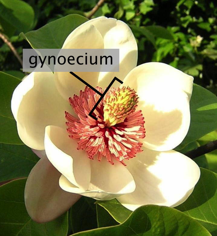
Gynoecium (; ; : gynoecia) is most commonly used as a collective term for the parts of a flower that produce ovules and ultimately develop into the fruit and seeds. The gynoecium is the innermost whorl of a flower; it consists of (one or more) '' pistils'' and is typically surrounded by the pollen-producing reproductive organs, the stamens, collectively called the androecium. The gynoecium is often referred to as the "female" portion of the flower, although rather than directly producing female gametes (i.e. egg cells), the gynoecium produces megaspores, each of which develops into a female gametophyte which then produces egg cells. The term gynoecium is also used by botanists to refer to a cluster of archegonia and any associated modified leaves or stems present on a gametophyte shoot in mosses, liverworts, and hornworts. The corresponding terms for the male parts of those plants are clusters of antheridia within the androecium. Flowers that bear a gynoecium but no stame ... [...More Info...] [...Related Items...] OR: [Wikipedia] [Google] [Baidu] |
Kuril Islands
The Kuril Islands or Kurile Islands are a volcanic archipelago administered as part of Sakhalin Oblast in the Russian Far East. The islands stretch approximately northeast from Hokkaido in Japan to Kamchatka Peninsula in Russia, separating the Sea of Okhotsk from the north Pacific Ocean. There are 56 islands and many minor islets. The Kuril Islands consist of the Greater Kuril Chain and, at the southwest end, the parallel Lesser Kuril Chain. The group termed the 'South Kurils' consists of those of the Lesser Kuril Chain together with Kunashir and Iturup in the Greater Kuril Chain. The Vries Strait between Iturup and Urup forms the Miyabe Line dividing the North and South Kurils. The Kuril Islands cover an area of around , with a population of roughly 20,000. The islands have been under Russian administration since their Invasion of the Kuril Islands, 1945 invasion by the Soviet Union near the end of World War II. Japan claims the four southernmost islands, including two of the ... [...More Info...] [...Related Items...] OR: [Wikipedia] [Google] [Baidu] |
Khabarovsk
Khabarovsk ( ) is the largest city and the administrative centre of Khabarovsk Krai, Russia,Law #109 located from the China–Russia border, at the confluence of the Amur and Ussuri Rivers, about north of Vladivostok. As of the 2021 Russian census, it had a population of 617,441. It was known as ''Khabarovka'' until 1893. The city was the administrative center of the Far Eastern Federal District of Russia from 2002 until December 2018, when the status was given to Vladivostok. As is typical of the interior of the Russian Far East, Khabarovsk has an extreme climate with strong seasonal swings resulting in strong, cold winters and relatively hot and humid summers. History Earliest record Historical records indicate that a city was founded on the site in the eighth century. The Tungusic peoples are indigenous to the city's vicinity. The city was named ( zh, t= 伯力, p=Bólì, labels=no) in Chinese when it was part of the Chinese empire. During the Tang dynasty, Boli was th ... [...More Info...] [...Related Items...] OR: [Wikipedia] [Google] [Baidu] |
Kamchatka
The Kamchatka Peninsula (, ) is a peninsula in the Russian Far East, with an area of about . The Pacific Ocean and the Sea of Okhotsk make up the peninsula's eastern and western coastlines, respectively. Immediately offshore along the Pacific coast of the peninsula runs the Kuril–Kamchatka Trench. The Kamchatka Peninsula, the Commander Islands, and Karaginsky Island constitute Kamchatka Krai of the Russia, Russian Federation. The majority of the 322,079 inhabitants are ethnic Russians, with about 13,000 being Koryaks (2014). More than half of the population lives in Petropavlovsk-Kamchatsky (179,526 in 2010) and nearby Yelizovo (38,980). The Kamchatka Peninsula contains the volcanoes of Kamchatka, a UNESCO World Heritage Site, that form part of the Ring of Fire. Geography Politically, the peninsula forms part of Kamchatka Krai. The southern tip is called Cape Lopatka. (Lopatka is Russian for spade.) The circular bay to the north of this on the Pacific side is Avac ... [...More Info...] [...Related Items...] OR: [Wikipedia] [Google] [Baidu] |
Amur
The Amur River () or Heilong River ( zh, s=黑龙江) is a perennial river in Northeast Asia, forming the natural border between the Russian Far East and Northeast China (historically the Outer Manchuria, Outer and Inner Manchuria). The Amur ''proper'' is long, and has a drainage basin of .Амур (река в Азии) Great Soviet Encyclopedia If including its main stem tributary, the Argun (Amur), Argun, the Amur is long, making it the list of longest rivers, world's tenth longest river. The Amur is an important river for the aquatic animal, aquatic fauna of Northeast Asia. The river basin is home to a variety of large predatory fish such as northern snakehead, Amur pike, taimen, Amur catfish, predatory carp and Elopichthys bambusa, yellowcheek, as wel ... [...More Info...] [...Related Items...] OR: [Wikipedia] [Google] [Baidu] |
Nei Mongol
Inner Mongolia, officially the Inner Mongolia Autonomous Region, is an Autonomous regions of China, autonomous region of China. Its border includes two-thirds of the length of China's China–Mongolia border, border with the country of Mongolia. Inner Mongolia also accounts for a small section of China's China–Russia border, border with Russia (Zabaykalsky Krai). Its capital is Hohhot; other major cities include Baotou, Chifeng, Tongliao, and Ordos City, Ordos. The autonomous region was established in 1947, incorporating the areas of the former Republic of China (1912–1949), Republic of China provinces of Suiyuan, Chahar Province, Chahar, Rehe Province, Rehe, Liaobei, and Xing'an Province, Xing'an, along with the northern parts of Gansu and Ningxia. Its area makes it the List of Chinese administrative divisions by area, third largest Chinese administrative subdivision, constituting approximately and 12% of China's total land area. Due to its long span from east to west, Inn ... [...More Info...] [...Related Items...] OR: [Wikipedia] [Google] [Baidu] |
Liaoning
) , image_skyline = , image_alt = , image_caption = Clockwise: Mukden Palace in Shenyang, Xinghai Square in Dalian, Dalian coast, Yalu River at Dandong , image_map = Liaoning in China (+all claims hatched).svg , mapsize = 275px , map_alt = Map showing the location of Liaoning Province , map_caption = Map showing the location of Liaoning Province , coordinates = , subdivision_type = Country , subdivision_name = China , named_for = —"Liao River, Liao (River)" —"pacification" "Pacified of the Liao (River)" , seat_type = Capital , seat = Shenyang , seat1_type = , seat1 = , parts_type = Divisions , parts_style = para , p1 = 14 Prefectures of China, prefectures , p2 = 100 Counties of China, counties , p3 = 1511 Townships of China, townships , government_type = Provinces of ... [...More Info...] [...Related Items...] OR: [Wikipedia] [Google] [Baidu] |
Jilin
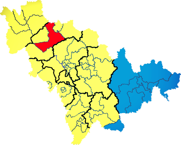
) , image_skyline = Changbaishan Tianchi from western rim.jpg , image_alt = , image_caption = View of Heaven Lake , image_map = Jilin in China (+all claims hatched).svg , mapsize = 275px , map_alt = Map showing the location of Jilin Province , map_caption = Map showing the location of Jilin Province , coordinates = , subdivision_type = Country , subdivision_name = China , named_for = from ''girin ula'', a Manchu language, Manchu phrase meaning "along the river" , seat_type = Capital , seat = , seat1_type = , seat1 = , parts_type = Divisions , parts_style = para , p1 = 9 Prefectures of China, prefectures , p2 = 60 Counties of China, counties , p3 = 1006 Townships of China, townships , government_type = Provinces of China, Province , governing_body = Jilin Provinci ... [...More Info...] [...Related Items...] OR: [Wikipedia] [Google] [Baidu] |
Heilongjiang
Heilongjiang is a province in northeast China. It is the northernmost and easternmost province of the country and contains China's northernmost point (in Mohe City along the Amur) and easternmost point (at the confluence of the Amur and Ussuri rivers). The province is bordered by Jilin to the south and Inner Mongolia to the west. It also shares a border with Russia ( Amur Oblast, Jewish Autonomous Oblast, Khabarovsk Krai, Primorsky Krai and Zabaykalsky Krai) to the north and east. The capital and the largest city of the province is Harbin. Among Chinese provincial-level administrative divisions, Heilongjiang is the sixth-largest by total area, the 20th-most populous, and the second-poorest by GDP per capita after only Gansu province. The province takes its name from the Amur river which marks the border between the People's Republic of China and Russia. Heilongjiang has significant agricultural production, and raw materials, such as timber, oil, and coal. Etymology ... [...More Info...] [...Related Items...] OR: [Wikipedia] [Google] [Baidu] |
Hebei
Hebei is a Provinces of China, province in North China. It is China's List of Chinese administrative divisions by population, sixth-most populous province, with a population of over 75 million people. Shijiazhuang is the capital city. It borders Shanxi to the west, Henan to the south, Shandong and Liaoning to the east, and Inner Mongolia to the north; in addition, Hebei entirely surrounds the direct-administered municipalities of Beijing and Tianjin on land. Its population is 96% Han Chinese, 3% Manchu people, Manchu, 0.8% Hui people, Hui, and 0.3% Mongols in China, Mongol. Varieties of Chinese spoken include Jilu Mandarin, the Beijing dialect of Mandarin, and Jin Chinese. During the Spring and Autumn period, Spring and Autumn and Warring States periods (771–226 BC), the region was ruled by the states of Yan (state), Yan and Zhao (state), Zhao. During the Yuan dynasty (1271–1368), the region was called Zhongshu Sheng, Zhongshu. It was called North Zhili during the ... [...More Info...] [...Related Items...] OR: [Wikipedia] [Google] [Baidu] |
Species Distribution
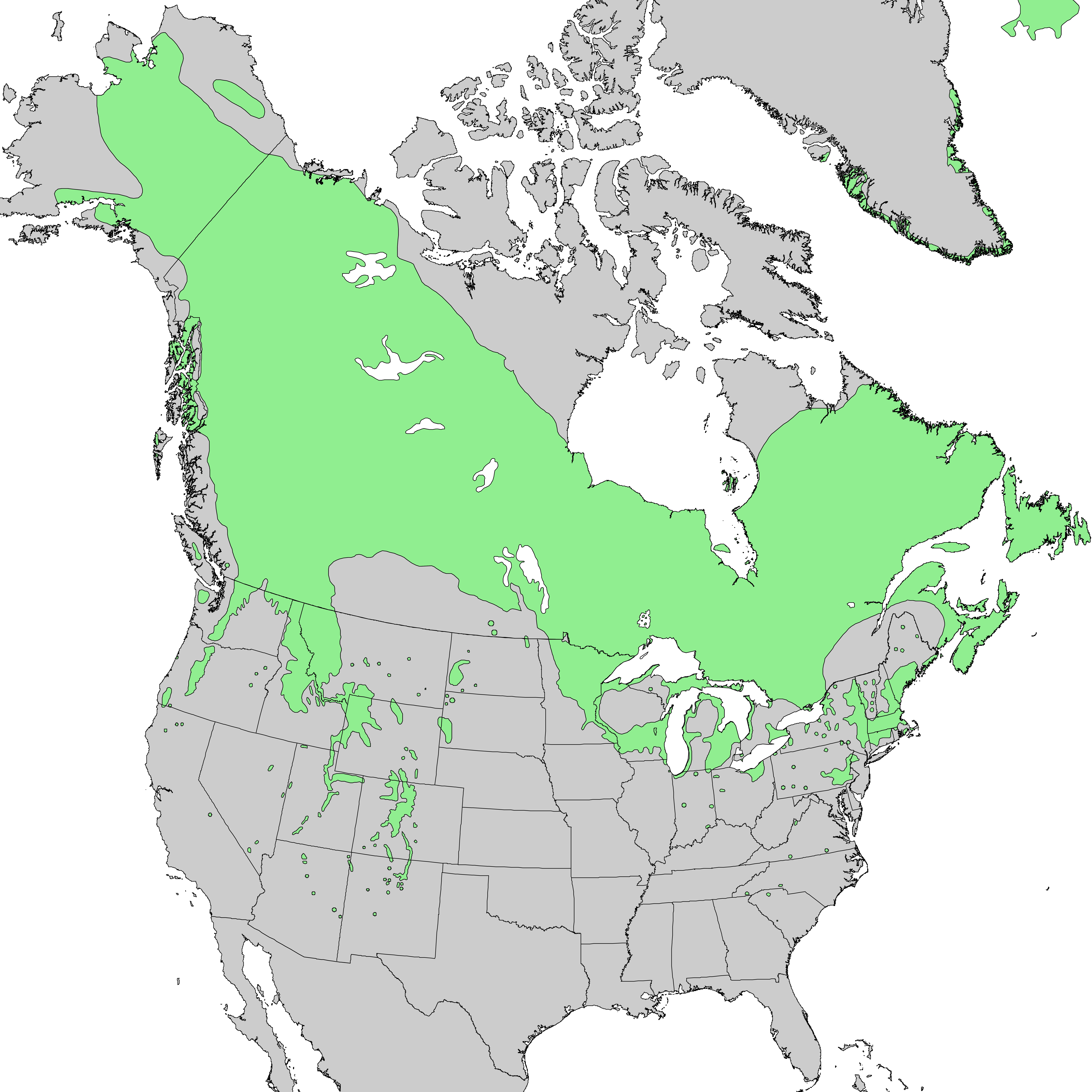
Species distribution, or species dispersion, is the manner in which a biological taxon is spatially arranged. The geographic limits of a particular taxon's distribution is its range, often represented as shaded areas on a map. Patterns of distribution change depending on the scale at which they are viewed, from the arrangement of individuals within a small family unit, to patterns within a population, or the distribution of the entire species as a whole (range). Species distribution is not to be confused with biological dispersal, dispersal, which is the movement of individuals away from their center of origin, region of origin or from a population center of high population density, density. Range In biology, the range of a species is the geographical area within which that species can be found. Within that range, distribution is the general structure of the species population, while dispersion is the variation in its population density. Range is often described with the foll ... [...More Info...] [...Related Items...] OR: [Wikipedia] [Google] [Baidu] |


