|
Red Lake Band Of Chippewa
The Red Lake Indian Reservation () covers in parts of nine counties in Minnesota, United States. It is made up of numerous holdings but the largest section is an area around Red Lake, in north-central Minnesota, the largest lake in the state. This section lies primarily in the counties of Beltrami and Clearwater. Land in seven other counties is also part of the reservation. The reservation population was 5,506 in the 2020 census. The second-largest section () is much farther north, in the Northwest Angle of Lake of the Woods County near the Canada–United States border. It has no permanent residents. Between these two largest sections are hundreds of mostly small, non-contiguous reservation exclaves in the counties of Beltrami, Clearwater, Lake of the Woods, Koochiching, Roseau, Pennington, Marshall, Red Lake, and Polk. Home to the federally recognized Red Lake Band of Chippewa, it is unique as the only "closed reservation" in Minnesota. In a closed rese ... [...More Info...] [...Related Items...] OR: [Wikipedia] [Google] [Baidu] |
Indian Reservation
An American Indian reservation is an area of land land tenure, held and governed by a List of federally recognized tribes in the contiguous United States#Description, U.S. federal government-recognized Native American tribal nation, whose government is Tribal sovereignty in the United States, autonomous, subject to regulations passed by the United States Congress and administered by the United States Bureau of Indian Affairs, and not to the state governments of the United States, U.S. state government in which it is located. Some of the country's 574 List of Native American Tribal Entities, federally recognized tribes govern more than one of the 326 List of Indian reservations in the United States, Indian reservations in the United States, while some share reservations, and others have no reservation at all. Historical piecemeal land allocations under the Dawes Act facilitated sales to non–Native Americans, resulting in some reservations becoming severely fragmented, with pie ... [...More Info...] [...Related Items...] OR: [Wikipedia] [Google] [Baidu] |
Red Lake County, Minnesota
Red Lake County is a county in the Northwestern part of the U.S. state of Minnesota. As of the 2020 census, the population was 3,935, making it the third-least populous county in Minnesota. Its county seat is Red Lake Falls. History Red Lake County was formed on December 24, 1896, from sections of Polk County. It was named for the Red Lake River. Its designated county seat was Red Lake Falls, which had been incorporated (as a village) in 1881. The county has two sites on the National Register of Historic Places: the courthouse and Clearwater Evangelical Lutheran Church. Geography The Red Lake River flows southward into the county from Pennington County. It is joined near Red Lake Falls by the Clearwater River; the combined flow (still known as the Red Lake River) flows southwestward to Huot, where it is augmented by the Black River, which drains the northwestern part of the county. The Red Lake River then flows southwestward into Polk County. The county terrain c ... [...More Info...] [...Related Items...] OR: [Wikipedia] [Google] [Baidu] |
Marshall County, Minnesota
Marshall County is a County (United States), county in the northwestern part of the U.S. state of Minnesota. As of the 2020 United States census, 2020 census, the population was 9,040. Its county seat is Warren, Minnesota, Warren. History The Minnesota legislature created the county on February 25, 1879, with territory partitioned from the southern half of Kittson County, Minnesota, Kittson County, with Warren, Minnesota, Warren (which was first platted that same year) as the county seat. It was named for William Rainey Marshall, who served as Minnesota governor from 1866 to 1870. Marshall County was the location of a claimed Unidentified flying object, UFO incident in 1979, the Val Johnson incident. Geography Marshall County lies on Minnesota's border with North Dakota (across the Red River of the North, Red River, which flows north along the county's western border). The Snake River (Red River of the North tributary), Snake River rises in Polk County, Minnesota, Polk County ... [...More Info...] [...Related Items...] OR: [Wikipedia] [Google] [Baidu] |
Pennington County, Minnesota
Pennington County is a county in the northwestern part of the U.S. state of Minnesota. As of the 2020 census, the population was 13,992. Its county seat is Thief River Falls. History The Wisconsin Territory was established by the federal government effective July 3, 1836, and existed until its eastern portion was granted statehood (as Wisconsin) in 1848. The federal government set up the Minnesota Territory in the remaining territory, effective March 3, 1849. The newly organized territorial legislature created nine counties across the territory in October of that year. One of those original counties, Pembina, had its lower portion partitioned in 1858 by the newly organized Minnesota State legislature to create Polk County. On December 24, 1896, the legislature partitioned the northern portion of Polk to create Red Lake County. Then on November 23, 1910, the northern part of Red Lake was sectioned off to create Pennington County, the penultimate Minnesota county to be creat ... [...More Info...] [...Related Items...] OR: [Wikipedia] [Google] [Baidu] |
Roseau County
Roseau County () is a county in the northwestern part of the U.S. state of Minnesota, along the Canada–U.S. border. As of the 2020 census, the population was 15,331. Its county seat is Roseau. Roseau County borders the Canadian province of Manitoba. Part of the Red Lake Indian Reservation is in Roseau County. History Roseau County was once the home of many Ojibwe, Sioux, and Mandan tribes. Archeologists have found artifacts within the county belonging to these tribes that date back 7,200 years. More recent history includes fur trappers and European-based explorers. By 1822, a fur-trading post was established in the area. In 1885, the future Roseau City hosted four settlers; by 1895 there were 600, and the area was incorporated as Roseau. By the mid-1880s the early settlers of eastern Kittson County were feeling the disadvantage of their location, far from the county seat, and petitioned the government for a separate county. On December 31, 1894, Governor Knute Nelson pr ... [...More Info...] [...Related Items...] OR: [Wikipedia] [Google] [Baidu] |
Koochiching County
Koochiching County ( ) is a county in the U.S. state of Minnesota. As of the 2020 census, the population was 12,062. Its county seat is International Falls. A portion of the Bois Forte Indian Reservation is in the county. A small part of Voyageurs National Park extends into its boundary, with Lake of the Woods County to its northwest. History About 10,000 years ago almost 90% of Koochiching County was covered by Lake Agassiz. When it receded it left low areas of decayed vegetation (muskeg); as a result, three-quarters of northern Koochiching are underlain with 2 to 50 feet of peat. The name "Koochiching" comes from either the Ojibwe word ''Gojijiing'' or Cree ''Kocicīhk'' (recorded in some documents as "Ouchichiq"), both meaning "at the place of inlets," referring to the neighboring Rainy Lake and River. Reverend J.A. Gilfillan recorded their meaning, "according to some, Neighbor lake, according to others a lake somewhere," possibly referring to the neighbouring Rainy Lake ... [...More Info...] [...Related Items...] OR: [Wikipedia] [Google] [Baidu] |
Exclave
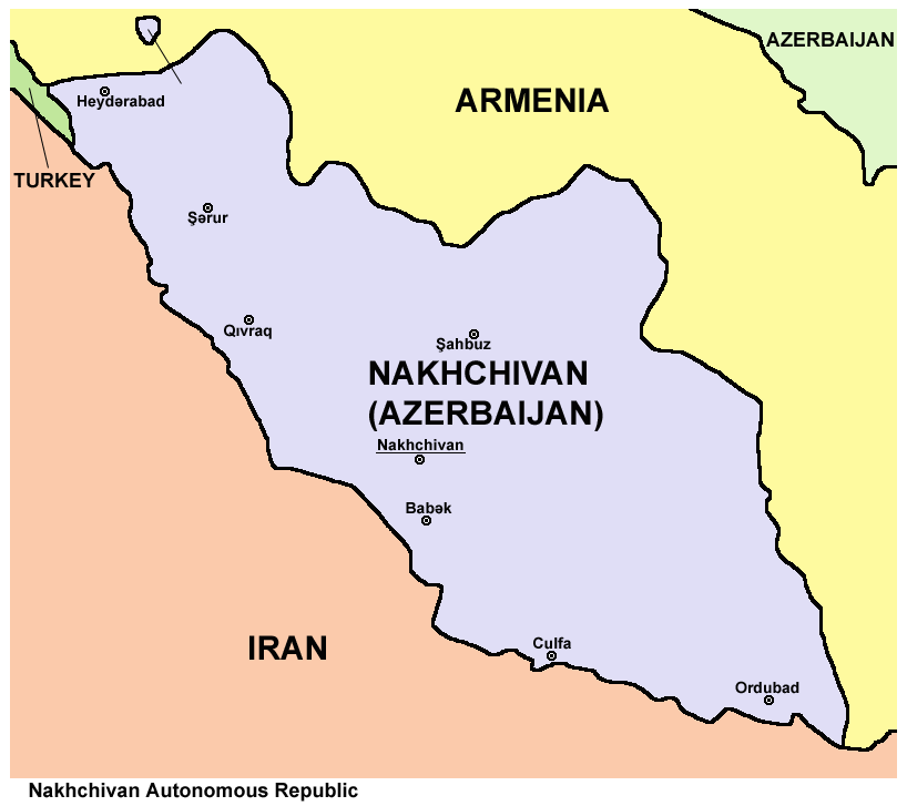
An enclave is a territory that is entirely surrounded by the territory of only one other state or entity. An enclave can be an independent territory or part of a larger one. Enclaves may also exist within territorial waters. ''Enclave'' is sometimes used improperly to denote a territory that is only partly surrounded by another state. Enclaves that are not part of a larger territory are not exclaves, for example Lesotho (enclaved by South Africa), and San Marino and Vatican City (both enclaved by Italy) are enclaved sovereign states. An exclave is a portion of a state or district geographically separated from the main part, by some surrounding alien territory. Many exclaves are also enclaves, but an exclave surrounded by the territory of more than one state is not an enclave. The Azerbaijani exclave of Nakhchivan is an example of an exclave that is not an enclave, as it borders Armenia, Iran, and Turkey. Semi-enclaves and semi-exclaves are areas that, except for possessing ... [...More Info...] [...Related Items...] OR: [Wikipedia] [Google] [Baidu] |
Canada–United States Border
The international border between Canada and the United States is the longest in the world by total length. The boundary (including boundaries in the Great Lakes, Atlantic, and Pacific coasts) is long. The land border has two sections: Canada's border with the Northern Tier (United States), northern tier of the contiguous United States to its south, and with the U.S. state of Alaska to its west. The bi-national International Boundary Commission deals with matters relating to marking and maintaining the boundary, and the International Joint Commission deals with issues concerning boundary waters. The agencies responsible for facilitating legal passage through the international boundary are the Canada Border Services Agency (CBSA) and U.S. Customs and Border Protection (CBP). History 18th century The Treaty of Paris (1783), Treaty of Paris of 1783 ended the American Revolutionary War between Kingdom of Great Britain, Great Britain and the United States. In the second article o ... [...More Info...] [...Related Items...] OR: [Wikipedia] [Google] [Baidu] |
Lake Of The Woods County, Minnesota
Lake of the Woods County is the northernmost county of the U.S. state of Minnesota. As of the 2020 census, the population was 3,763, making it the second-least populous county in Minnesota. Its county seat is Baudette. The county contains the Northwest Angle, the northernmost point of the Lower 48 States, and the U.S. portion of Lake of the Woods, shared with Canada. The county also includes the exclave of Elm Point. Since Alaska has no counties, Lake of the Woods is the northernmost county in the United States. It is also the only county in the United States with four words in its name, although there is a parish in Louisiana called St. John the Baptist Parish, and the United States Census Bureau treats parishes as county equivalents for census purposes. History Lake of the Woods County was named for the lake that covers a large portion of it. Jacques de Noyon, a Frenchman who came from Trois Rivières, Quebec, explored the area in 1688 and was the first European to s ... [...More Info...] [...Related Items...] OR: [Wikipedia] [Google] [Baidu] |
Northwest Angle
The Northwest Angle, known simply as the Angle by locals, and coextensive with Angle Township, is a pene-exclave of northern Lake of the Woods County, Minnesota. Excluding surveying errors, it is the only place in the contiguous United States north of the 49th parallel north, 49th parallel, which forms the border between the U.S. and Canada from the Northwest Angle westward to the Strait of Georgia (between the U.S. state of Washington (state), Washington and the Canadian province of British Columbia). The land area of the Angle is separated from the rest of Minnesota by Lake of the Woods, but shares a land border with Canada. It is one of Canada–United States border#Practical exclaves of the United States, six non-island locations in the 48 contiguous states that are Enclave and exclave#"Practical" enclaves, exclaves and inaccessible districts, practical exclaves of the United States. Oak Island (Minnesota), Oak Island, Angle Inlet, Minnesota, Angle Inlet and Penasse, Minnes ... [...More Info...] [...Related Items...] OR: [Wikipedia] [Google] [Baidu] |


