|
Orange Line (other)
Orange Line may refer to: Public transit in Asia *Orange Line or Delhi Airport Metro Express in Delhi, India *Orange Line (Jaipur Metro) in Jaipur, India *Orange Line (Kanpur Metro), in Kanpur, India * Orange Line (Nagpur Metro), in Nagpur, India *Orange Line (Namma Metro) a planned line in Bengaluru, India * Orange Line (Lahore Metro) in Lahore, Pakistan *Orange Line, KMRT, Kaohsiung, Taiwan *Orange Line (Bangkok), a planned line in Bangkok, Thailand * Line 1 (Busan), South Korea * Line 2 (Incheon), South Korea *Line 3 (Seoul), South Korea * U Line, Uijeongbu, South Korea * Tung Chung line, Hong Kong, China * Zhonghe-Xinlu Line of Taipei Metro, Taipei, Taiwan * PNR Metro South Commuter Line, Manila, Philippines *Ampang Line, Kuala Lumpur *Circle MRT line, Singapore Public transit in Europe * Kaluzhsko-Rizhskaya line, Moscow, Russia * London Overground, London, UK * Paris Métro Line 5, Paris, France * Brussels Metro line 2, Brussels, Belgium *Line 7 (Madrid Metro), Madrid, Spain ... [...More Info...] [...Related Items...] OR: [Wikipedia] [Google] [Baidu] |
Delhi Airport Metro Express
The Delhi Airport Express Line or Orange Line is a Delhi Metro line from New Delhi Metro Station to Dwarka Sector 21, linking Indira Gandhi International Airport. The total length of the line is 22.7 km, of which 15.7 km is underground and 7 km, from Buddha Jayanti Park to Mahipalpur, is elevated. On 27 June 2013 Reliance Infrastructure Ltd. announced to DMRC that they are unable to operate the line beyond 30 June 2013. Following this, DMRC took over operations of Airport Express line from 1 July 2013 with an operations and maintenance team of 100 officials to handle the line. The line runs at a speed of 80 km/h providing for a 19-minute journey from New Delhi to IGI Airport. History The first tenders for line construction were awarded in September 2007. On 23 January 2008, the DMRC awarded a 30-year build-operate-transfer PPP contract to the Reliance Energy- CAF consortium. However, DMRC paid for half of the construction cost and executed tunneling and c ... [...More Info...] [...Related Items...] OR: [Wikipedia] [Google] [Baidu] |
Orange Line (MBTA)
The Orange Line is a rapid transit line operated by the Massachusetts Bay Transportation Authority (MBTA) as part of the MBTA subway system. The line runs south on the surface from Oak Grove station in Malden, Massachusetts through Malden and Medford, paralleling the Haverhill Line, then crosses the Mystic River on a bridge into Somerville, then into Charlestown. It passes under the Charles River and runs through Downtown Boston in the Washington Street Tunnel. The line returns to the surface in the South End, then follows the Southwest Corridor southwest in a cut through Roxbury and Jamaica Plain to Forest Hills station. The Orange Line operates during normal MBTA service hours (all times except late nights) with six-car trains. A 120-car fleet built in 1979–1981 is being replaced with a 152-car CRRC fleet from 2018 to 2023. The Orange Line is fully grade-separated; trains are driven by operators with automatic train control for safety. Wellington Carhouse in Medford ... [...More Info...] [...Related Items...] OR: [Wikipedia] [Google] [Baidu] |
G Line (Los Angeles Metro)
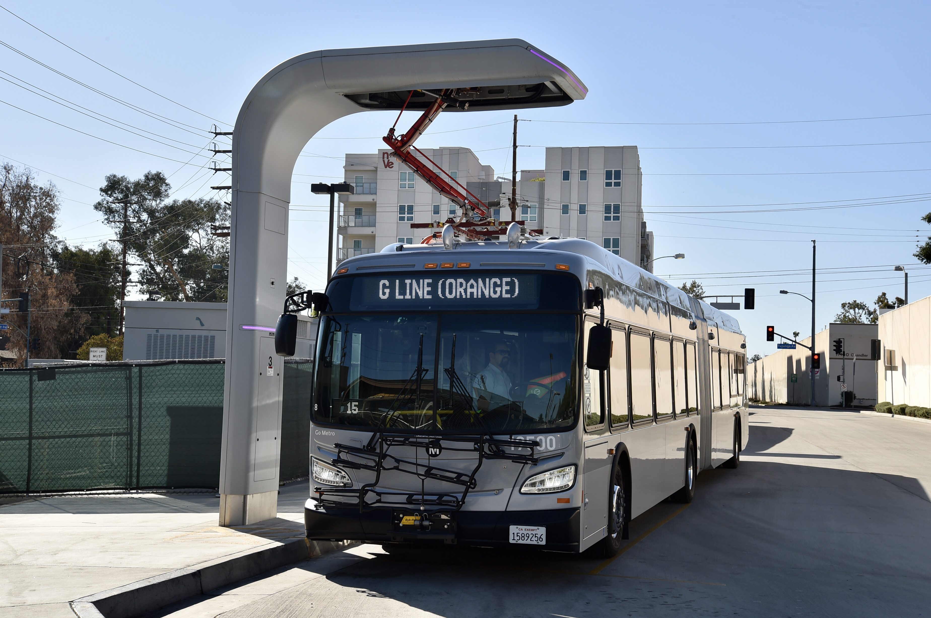
The G Line (formerly the Orange Line) is a bus rapid transit line in Los Angeles, California, operated by the Los Angeles County Metropolitan Transportation Authority (Metro). It operates between and stations in the San Fernando Valley. The G Line uses a dedicated, exclusive right-of-way for the entirety of its route with 17 stations located at approximately intervals; fares are paid via TAP cards at vending machines on station platforms before boarding to improve performance. It is one of the two lines in the Metro Busway system. The line, which opened on October 29, 2005, follows part of the Southern Pacific Railroad's former Burbank Branch Line which provided passenger rail service from 1904 to 1920; it was subsequently used by Pacific Electric streetcars from 1911 to 1952. At North Hollywood station, the G Line connects with the B Line subway which offers service to Downtown Los Angeles via Hollywood. The Metro Orange Line bicycle path runs alongside part of th ... [...More Info...] [...Related Items...] OR: [Wikipedia] [Google] [Baidu] |
Orange Line (Dallas Area Rapid Transit)
The Orange Line (labeled as the Purple Line on maps prior to 2006) is a light rail line operated by the Dallas Area Rapid Transit system in Dallas, Irving, Richardson and Plano, Texas. It runs from DFW Airport via downtown Dallas to Plano. Route The line's current northwestern terminus is DFW Airport Station, located inside Dallas/Fort Worth International Airport. The line proceeds southeast through Irving, providing service to the Irving Convention Center, Las Colinas, and the University of Dallas, before merging with the Green Line north of Bachman Station and proceeding southwest to Downtown Dallas. The Orange Line shares the rest of its route with existing light rail lines, with stops along the Green Line from Bachman to Victory Station, through downtown Dallas on a corridor shared with the Green Line, Blue Line, and Red Line, and then northward along the Red Line corridor through Richardson to Plano. Planned future Orange Line stations include a DFW North ... [...More Info...] [...Related Items...] OR: [Wikipedia] [Google] [Baidu] |
Orange Line (CTA)
The Orange Line is a rapid transit line in Chicago, Illinois, operated by the Chicago Transit Authority as part of the Chicago "L" system. It is approximately long and runs on elevated and at grade tracks and serves the Southwest Side, running from the Loop to Midway International Airport. As of 2021, an average of 11,006 riders board Orange Line trains on weekdays. Route The Orange Line begins in an open cut at a station on the east side of Midway International Airport. From here, the line rises to an elevated viaduct at 55th Street and continues northeast towards the city on railroad right-of-way. Near the intersection of 49th Street and Lawndale Avenue, the line turns east along a CSX right-of-way to a point east of Western Boulevard, then curves north and northwest on embankment structure along CSX right-of-way to Western Boulevard and Pershing Road. From here, the line rises on elevated structure again and makes a curve to cross Archer Avenue, the CSX tracks and Western B ... [...More Info...] [...Related Items...] OR: [Wikipedia] [Google] [Baidu] |
MAX Orange Line
The MAX Orange Line is a light rail service in Portland, Oregon, United States, operated by TriMet as part of the MAX Light Rail system. It connects Portland City Center, Portland State University (PSU), Southeast Portland, Milwaukie, and Oak Grove. The line serves 17 stations from Union Station/Northwest 5th & Glisan to and runs for 20 hours daily with a minimum headway of 15 minutes during most of the day. It averaged 3,480 daily weekday riders in September 2020. The Orange Line starts near Portland Union Station on north end of the Portland Transit Mall in downtown Portland. Within the transit mall, it operates as a southbound through service of the Yellow Line from Union Station/Northwest 5th & Glisan station on 5th Avenue and shares the tracks with the Green Line. Northbound, the Orange Line operates through to the Yellow Line at PSU South/Southwest 6th and College station on 6th Avenue and terminates at Expo Center station in North Portland. South of the transit ... [...More Info...] [...Related Items...] OR: [Wikipedia] [Google] [Baidu] |
Eglinton Crosstown Line
Line 5 Eglinton (also known as the Eglinton Crosstown or the Crosstown) is a light rail line that is under construction in Toronto, Ontario, Canada. Owned by Metrolinx and operated by the Toronto Transit Commission (TTC), the line will be part of the Toronto subway system as its fifth route. The first phase of the line will include 25 stops along Eglinton Avenue, from Mount Dennis station underground to station, after which it will run predominantly at-grade within the street's median to Kennedy station, where it will connect underground with Line 2 Bloor–Danforth and Line 3 Scarborough. The line was conceived in 2007 during the administration of Toronto mayor David Miller as part of Transit City, a large-scale transit expansion plan. Construction of the first phase of the line began in 2011 and was originally expected to be completed in 2020; it has been delayed more than once, and as of November 2021, Metrolinx and Crosslinx (the construction consortium) agreed on a ... [...More Info...] [...Related Items...] OR: [Wikipedia] [Google] [Baidu] |
Broad Street Line
The Broad Street Line (BSL), also known as the Broad Street subway (BSS), Orange Line, or Broad Line, is a subway line owned by the city of Philadelphia and operated by the Southeastern Pennsylvania Transportation Authority (SEPTA). The line runs primarily north-south from the Fern Rock Transportation Center in North Philadelphia through Center City Philadelphia to NRG station at Pattison Avenue in South Philadelphia; the latter station provides access to the stadiums and arenas for the city's major professional sports teams at the South Philadelphia Sports Complex, about a quarter mile away. It is named for Broad Street, under which the line runs for almost its entire length. The line, which is entirely underground except for the northern terminus at Fern Rock, has four tracks in a local/express configuration from Fern Rock to Walnut-Locust and two tracks from Lombard-South to the southern terminus at NRG station. It is one of only two rapid transit lines in the SEPT ... [...More Info...] [...Related Items...] OR: [Wikipedia] [Google] [Baidu] |
U9 (Berlin U-Bahn)
U9 is a line on the Berlin U-Bahn. The line was opened on 28 August 1961 as Line G. Route The path of the U9 is completely underground. It starts in the north at Osloer Straße in Gesundbrunnen and runs through Wedding before passing under the Berlin Ringbahn and running through Moabit, reaching Hansaplatz and Tiergarten before crossing the Berlin Stadtbahn at the Zoo and Kurfürstendamm, eventually leaving western central Berlin by heading to Friedenau and finally Steglitz at Rathaus Steglitz. History First stage of construction After the division of Berlin in 1948, the citizens of West Berlin preferred buses and trams that bypassed East Berlin. Furthermore, the highly populated boroughs of Steglitz, Wedding and Reinickendorf were in need of rapid transit access to the new center of West Berlin south of the Zoo. This prompted the construction of a completely new line, then called line G, becoming the third north–south line after line C (modern U6) and line D (modern U8). ... [...More Info...] [...Related Items...] OR: [Wikipedia] [Google] [Baidu] |
Line 7 (Madrid Metro)
Line 7 of the Madrid Metro is a rapid transit line that originally opened on 17 July 1974. It currently runs between and . History The line has been extended multiple times. It initially ran between and . On 17 May 1975, the line was extended from Pueblo Nuevo to , and was not extended for many years. This was a problem as line 7 was very underused. The problem was solved in 1998 and 1999 when an extension to was opened in four stages. The first stage was between Avenida de América and , opening on 1 April 1998, followed by Gregorio Marañón to . The next section to open extended the line to , and a final section further reached . Pitis, however, was the only station on the Madrid metro to have restricted opening times. At the time, Pitis was a very small village, and the station's main purpose is to provide interchange for Renfe services. Between 1999 and 2018, most trains ran between and , with being served by only a few trains each hour. Beginning in 2019, all trains ... [...More Info...] [...Related Items...] OR: [Wikipedia] [Google] [Baidu] |
.png)


.jpg)

