|
Ollerton Railway Station
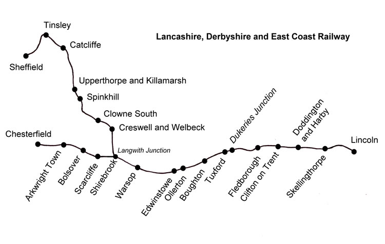
Ollerton railway station is a former railway station in Ollerton, Nottinghamshire, England. History The station was opened by the LD&ECR in 1896 and closed to local passenger traffic in 1955, though Summer holiday excursions to and from the East Coast continued to call until September 1964. The station, goods shed and signalbox were built to standard LD&ECR patterns. Large water tanks were erected at both ends of the site. Former services Two services called at Ollerton in 1922, but not on Sundays. Three trains per day ran between Chesterfield Market Place and Lincoln with a market day extra on Fridays between Langwith Junction and Lincoln. These called at all stations. The truncated remains of this service ended in September 1955. Three trains per day terminated at Ollerton from Nottingham Victoria via Mansfield Central then went back again half an hour or so later. This service was later cut back to Edwinstowe. A fourth train ran to Nottingham Victoria Monday to Friday, ... [...More Info...] [...Related Items...] OR: [Wikipedia] [Google] [Baidu] |
Ollerton
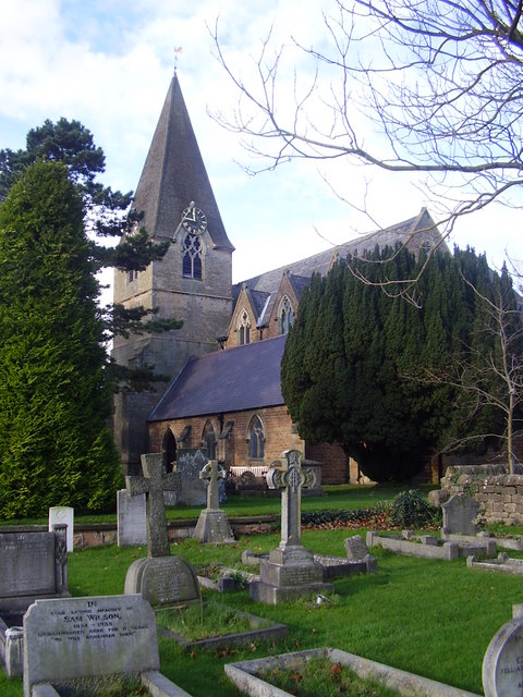
Ollerton is a village and former civil parish, now in the parish of Ollerton and Boughton, in the Newark and Sherwood district, in the county of Nottinghamshire, England, on the edge of Sherwood Forest in the area known as the Dukeries. The population of Ollerton and Boughton at the 2011 census was 9,840. The area is sometimes differentiated locally using the names New Ollerton for the post-1900 expansion, compared with Old Ollerton referring to the original village clustered around the church, river and mill.Statement of case on behalf of Nottinghamshire County Council "''The increase in levels of congestion at A614/A616/A6075 Ollerton Roundabout has also resulted in motorists seeking alternative routes to access and egress the A614, avoiding the Ollerton ... [...More Info...] [...Related Items...] OR: [Wikipedia] [Google] [Baidu] |
Farnsfield
Farnsfield is a large Village#United Kingdom, village and civil parish in Nottinghamshire in Sherwood Forest. It is in the local government district of Newark and Sherwood. The population of the civil parish as at the United Kingdom Census 2001 was 2,681, increasing in the 2011 United Kingdom census, 2011 census to 2,731, and 3,216 at the 2021 United Kingdom census, 2021 census. The village lies in a predominantly farming area. There is no major industry or employer within Farnsfield. The majority of residents of working age commute to work, mostly to Nottingham, Mansfield or Newark-on-Trent, Newark. Farnsfield's facilities include a small Co-op supermarket and Post Office Limited, Post Office, a village bakery, butcher, greengrocer, and other small shops. The village has two Church (building), churches (Anglicanism, Anglican and Methodism, Methodist), a large primary school, and two public houses (The Plough Inn and The Lion). The Southwell Trail, a former railway line dati ... [...More Info...] [...Related Items...] OR: [Wikipedia] [Google] [Baidu] |
Headington
Headington is an eastern suburb of Oxford, in the county of Oxfordshire, England. It is at the top of Headington Hill overlooking the city in the Thames valley below, and bordering Marston, Oxford, Marston to the north-west, Cowley, Oxfordshire, Cowley to the south, and Barton, Oxfordshire, Barton and Risinghurst to the east. The life of the large residential area is centred upon London Road, the main road between London and Oxford. History The site of Headington shows evidence of continued occupation from the Stone Age, as the 2001 field Excavation (archaeology), excavations in Barton, Oxfordshire, Barton Lane found, suggesting a date in the 11th century BC. Pottery was found on the Manor Ground, Oxford, Manor Ground, suggesting an British Iron Age, Iron Age settlement there in the 7th century BC. Roman Britain, Roman kilns from about 300 have been found, including one now on display at the Museum of Oxford. History of Anglo-Saxon England, Anglo-Saxon burial remains from about ... [...More Info...] [...Related Items...] OR: [Wikipedia] [Google] [Baidu] |
Trains Illustrated
''Trains Illustrated'' is a British rail transport magazine. The first edition of ''Trains Illustrated'' was published at the beginning of 1946. Due to post-war paper shortages, issues 1 to 8 appeared at varied intervals in 1946 and 1947. From issue 9 (April 1948) it was published quarterly, from issue 14 (August–September 1949) it became bi-monthly, and from issue 17 (February 1950) it became a monthly publication. The final issue under that title was volume XIV, no.159 (December 1961), after which the sequence continued under the ''Modern Railways'' title. Early issues were edited by Ian Allan and O.J.Morris, with Cecil J Allen taking over from issue 5 and G. Freeman Allen from issue 20; he remained editor until December 1961, when the final issue of Trains Illustrated came out. The journey beyond that continued with ''Modern Railways'', whose first edition was published in January 1962 as Volume XV, no. 160 in a sequence continuing from ''Trains Illustrated''.''Modern Railways ... [...More Info...] [...Related Items...] OR: [Wikipedia] [Google] [Baidu] |
Anston
Anston is a civil parish in South Yorkshire, England, formally known as North and South Anston. The parish of Anston consists of the settlements of North Anston and South Anston, divided by the Anston Brook. History Anston, first recorded as ''Anestan'' is from the Old English ''āna stān'', meaning "single or solitary stone". In the Domesday Book (1086) North and South Anston (''Anestan'' and ''Litelanstan'') were both held by Roger de Busli. South Anston was an ancient parish in the wapentake of Strafforth and Tickhill in the West Riding of Yorkshire. It was a large parish, also known as Anston cum Membris, which also included North Anston and the township of Woodsetts. When civil parishes were created in 1866, Woodsetts became a separate civil parish and the remaining part of the parish became the civil parish of North and South Anston. In 1974 the parish was transferred to the Metropolitan Borough of Rotherham in the new county of South Yorkshire. The original in ... [...More Info...] [...Related Items...] OR: [Wikipedia] [Google] [Baidu] |
Clophill
Clophill is a village and civil parishes in England, civil parish nucleated village, clustered on the north bank of the River Flit, Bedfordshire, England. It is recorded in the Domesday Book of 1086 as ''Clopelle''. "Clop" likely means 'tree-stump' in Old English. However, it also has cognate terms for clay, with which the soil of mid Bedfordshire is rich. Extent and demography In the 1851 census, the men of the parish numbered 560; of these, 238 were agricultural labourers; women numbered. In the 2011 Census the population was 1,750. The contiguous housing of Clophill Road and its side streets falls into the civil and ecclesiastical parishes of Maulden. Church St Mary's old church The old St Mary's Church was built around 1350, and replaced by a new church in the 1840s (250 m boxing the compass, SSW). It gradually fell into ruin, and as an inactive church, had restoration carried out for secular purposes in the early 2010s. Active churches The new St Mary's chur ... [...More Info...] [...Related Items...] OR: [Wikipedia] [Google] [Baidu] |
Boughton (Nottinghamshire) Railway Station
Boughton railway station served the village of Boughton in Nottinghamshire, England from 1897 to 1955 when it was closed. It has since been razed to the ground. Context The station was opened by the LD&ECR on its main line from to Lincoln. The LD&ECR was taken over by the GCR in 1907 and subsequently became part of the LNER in 1923 then British Railways on nationalisation in 1948. The platforms were wooden, similar to the high level platforms at Dukeries Junction. The stationmaster's house was characteristic of the line, but the station buildings were not, they appear to have been made of wood, ''Picture the Past'' but on another page Dow himself says otherwise. The line crossed a series of ridges between river valleys. From |
Edwinstowe Railway Station
Edwinstowe railway station is a former railway station in Edwinstowe, Nottinghamshire, England. History The station was opened by the Lancashire, Derbyshire and East Coast Railway in 1896 and closed by British Railways on 2 January 1956, though the last train ran on 31 December 1955. The station was envisaged as the centre of the line's passenger traffic and was one of only three to have a Refreshment room, the others being and . The station buildings and signalbox followed the company's standard modular architecture pattern. Context From the line entered the valley of the River Maun with Sherwood Forest visible to the north. This was, and is, an area known as The Dukeries, heavily promoted in the railway's literature in the hope of attracting tourist trade. This never materialised in LD&ECR days, but the success of the modern-day Center Parcs near to Edwinstowe suggests the company had the right idea at the wrong time. Former services There never was a Sunday service ... [...More Info...] [...Related Items...] OR: [Wikipedia] [Google] [Baidu] |
Warsop Railway Station
Warsop railway station is a former Train station, railway station in Market Warsop, Nottinghamshire, England. History The station was opened by the Lancashire, Derbyshire & East Coast Railway in March 1897 and closed by British Railways in 1955. The station building made use of the LD&ECR's standard modular architecture. After leaving Shirebrook North railway station, Shirebrook North station, the line crossed the Midland Railway, Midland Nottingham to Worksop line (since 1998 the Robin Hood Line) and passed the LD&ECR Warsop yard near Warsop Junction. This yard is used by DB Cargo UK. To the north was a branch to Warsop Main colliery with extensive marshalling yards, now closed. Shortly after this, in the days before the deep mines penetrating the limestone cap were sunk, the newly built line ran into countryside, crossed Warsop Vale on an embankment, and arrived at Warsop station. Between Warsop and Edwinstowe railway station, Edwinstowe the line climbed from the valley ... [...More Info...] [...Related Items...] OR: [Wikipedia] [Google] [Baidu] |
Robin Hood Line
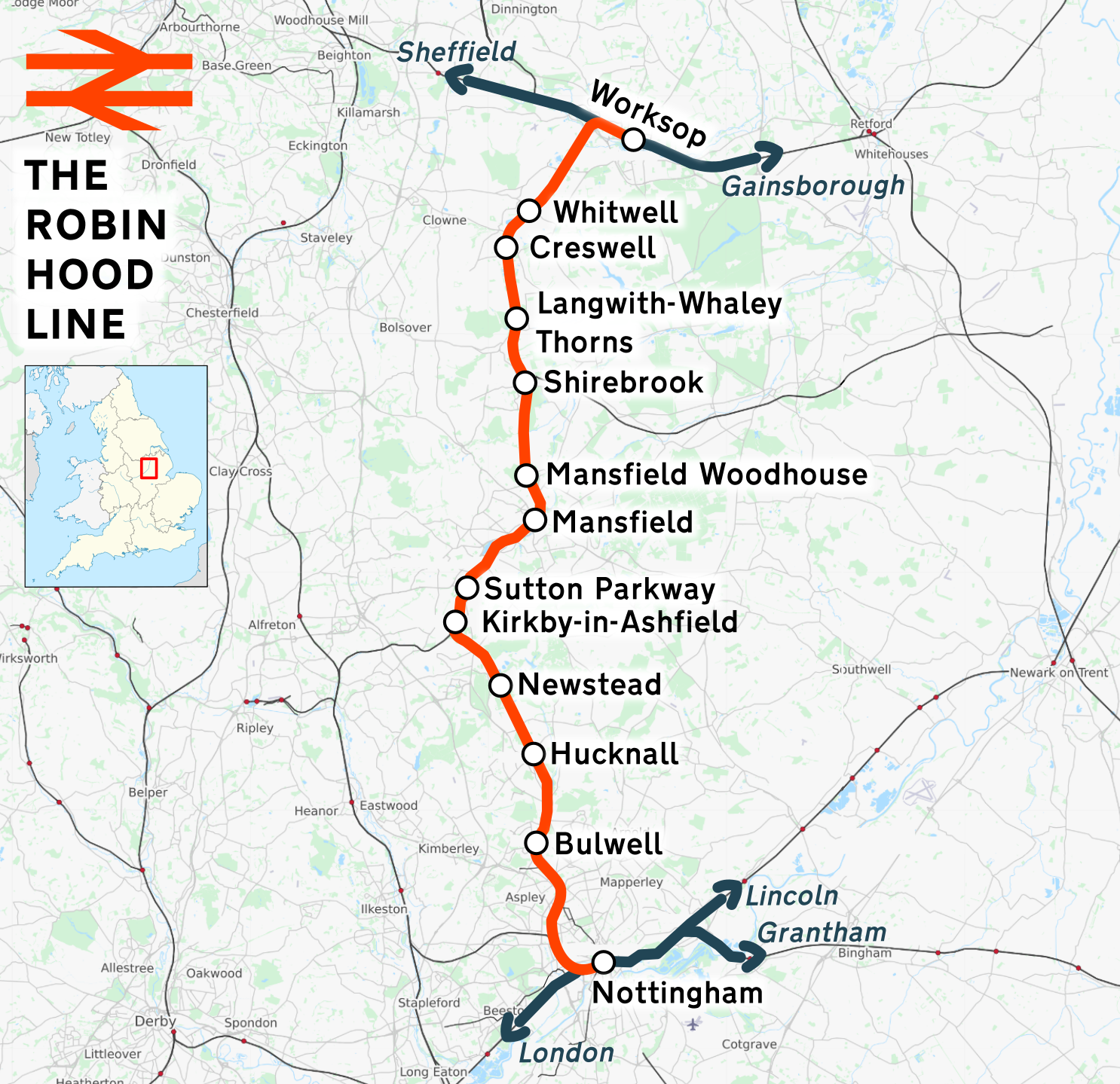
The Robin Hood Line is a railway line running from Nottingham to Worksop, Nottinghamshire, in England. The stations between Shirebrook and Whitwell (inclusive) are in the county of Derbyshire. Passenger services are operated by East Midlands Railway. The line in its present form opened to passengers in stages between 1993 and 1998. Following the Beeching cuts of the 1960s, the line had been freight-only. The cuts had left Mansfield as one of the largest towns in Britain without a railway station. History The majority of the current Robin Hood Line re-uses the former Midland Railway (MR) route from Nottingham to Worksop. However, due to rationalisation leading to track removal in order to save the costs of maintaining the tunnel north of Annesley, the through route was severed in the 1970s. Northwards from Nottingham, the freight-only line remained intact as far as Newstead, where it had served the now closed Newstead Colliery. Southwards from Worksop, the line followed ... [...More Info...] [...Related Items...] OR: [Wikipedia] [Google] [Baidu] |
Dukeries Junction Railway Station
Dukeries Junction, originally Tuxford Exchange, was a railway station near Tuxford, Nottinghamshire, England. The station opened in 1897 and closed in 1950. It was located at the bridge where the Lancashire, Derbyshire and East Coast Railway crossed over the East Coast Main Line (ECML), with sets of platforms on both lines. The high-level location is now part of the High Marnham Test Track. Nearby stations There were two other stations serving Tuxford. was one mile west of the bridge over the ECML, and was half a mile north of the bridge. Context The station was jointly opened by the Lancashire, Derbyshire and East Coast Railway, LD&ECR and Great Northern Railway (Great Britain), GNR on 1 June 1897. It was originally called "Tuxford Exchange", being situated where the LD&ECR's main line from Chesterfield Market Place railway station, Chesterfield Market Place to Lincoln Central railway station, Lincoln (later Lincoln Central) crossed over the GNR's main line from London Ki ... [...More Info...] [...Related Items...] OR: [Wikipedia] [Google] [Baidu] |
Tuxford Central Railway Station
Tuxford is a historic market town and a civil parish in the Bassetlaw district of Nottinghamshire, England. It had a population of 2,809 in the 2021 census. Geography Its nearby towns are Ollerton, Retford, Worksop, Mansfield and Newark-on-Trent. The nearest cities are Lincoln, Sheffield and Doncaster. The town is located near the border with Lincolnshire in The Dukeries. The A6075 passes through east–west and connects the A57 to Ollerton and Mansfield. The East Coast Main Line passes close to the east. The A611 previously went east–west through the town; this is now the A6075. The A611 now goes from Mansfield to Hucknall. The Great North Road runs through the town (now B1164), though the majority of traffic now uses the modern A1 trunk road, which splits the town in two. The town was bypassed in 1967. The section of road, known as Carlton to Markham Moor, or the Sutton-on-Trent, Weston and Tuxford Bypass, was built by Robert McGregor & Sons, with concreting ... [...More Info...] [...Related Items...] OR: [Wikipedia] [Google] [Baidu] |


