|
Ocean Bank (topography)
An ocean bank, sometimes referred to as a fishing bank or simply bank, is a part of the seabed that is shallow compared to its surrounding area, such as a shoal or the top of an underwater hill. Somewhat like continental slopes, ocean bank slopes can upwell as tidal and other flows intercept them, sometimes resulting in nutrient-rich currents. Because of this, some large banks, such as Dogger Bank and the Grand Banks of Newfoundland, are among the richest fishing grounds in the world. There are some banks that were reported in the 19th century by navigators, such as Wachusett Reef, whose existence is doubtful. Types Ocean banks may be of volcanic nature. Banks may be carbonate or terrigenous. In tropical areas some banks are submerged atolls. As they are not associated with any landmass, banks have no outside source of sediments. Carbonate banks are typically platforms, rising from the ocean depths, whereas terrigenous banks are elevated sedimentary deposits. Seamounts, ... [...More Info...] [...Related Items...] OR: [Wikipedia] [Google] [Baidu] |
Deep Sea
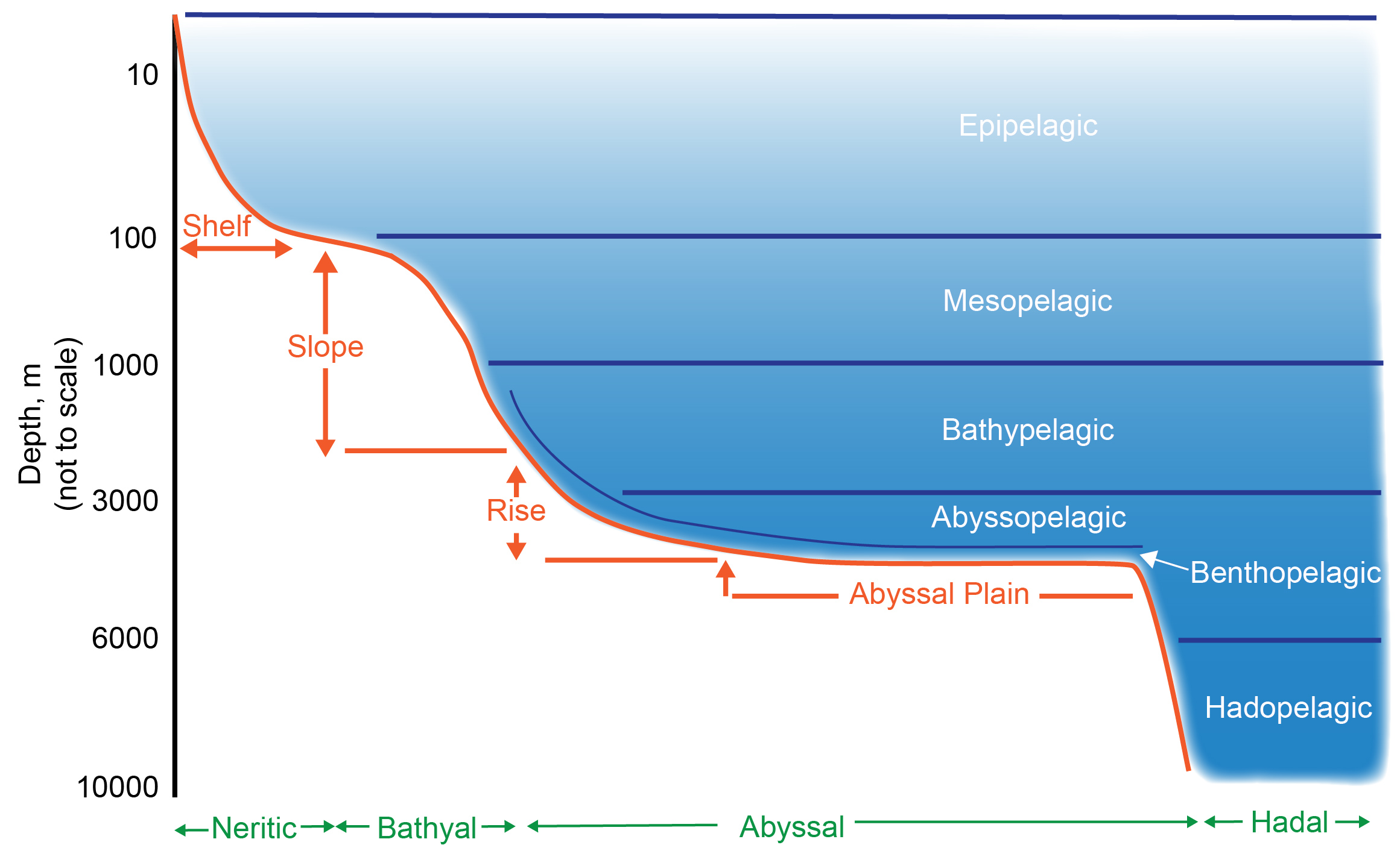
The deep sea is broadly defined as the ocean depth where light begins to fade, at an approximate depth of or the point of transition from continental shelves to continental slopes. Conditions within the deep sea are a combination of low temperatures, darkness, and high pressure. The deep sea is considered the least explored Earth biome as the extreme conditions make the environment difficult to access and explore. Organisms living within the deep sea have a variety of adaptations to survive in these conditions. Organisms can survive in the deep sea through a number of feeding methods including scavenging, predation and filtration, with a number of organisms surviving by feeding on marine snow. Marine snow is organic material that has fallen from upper waters into the deep sea. In 1960, the bathyscaphe ''Trieste'' descended to the bottom of the Mariana Trench near Guam, at , the deepest known spot in any ocean. If Mount Everest () were submerged there, its peak would be more ... [...More Info...] [...Related Items...] OR: [Wikipedia] [Google] [Baidu] |
Spratly Islands
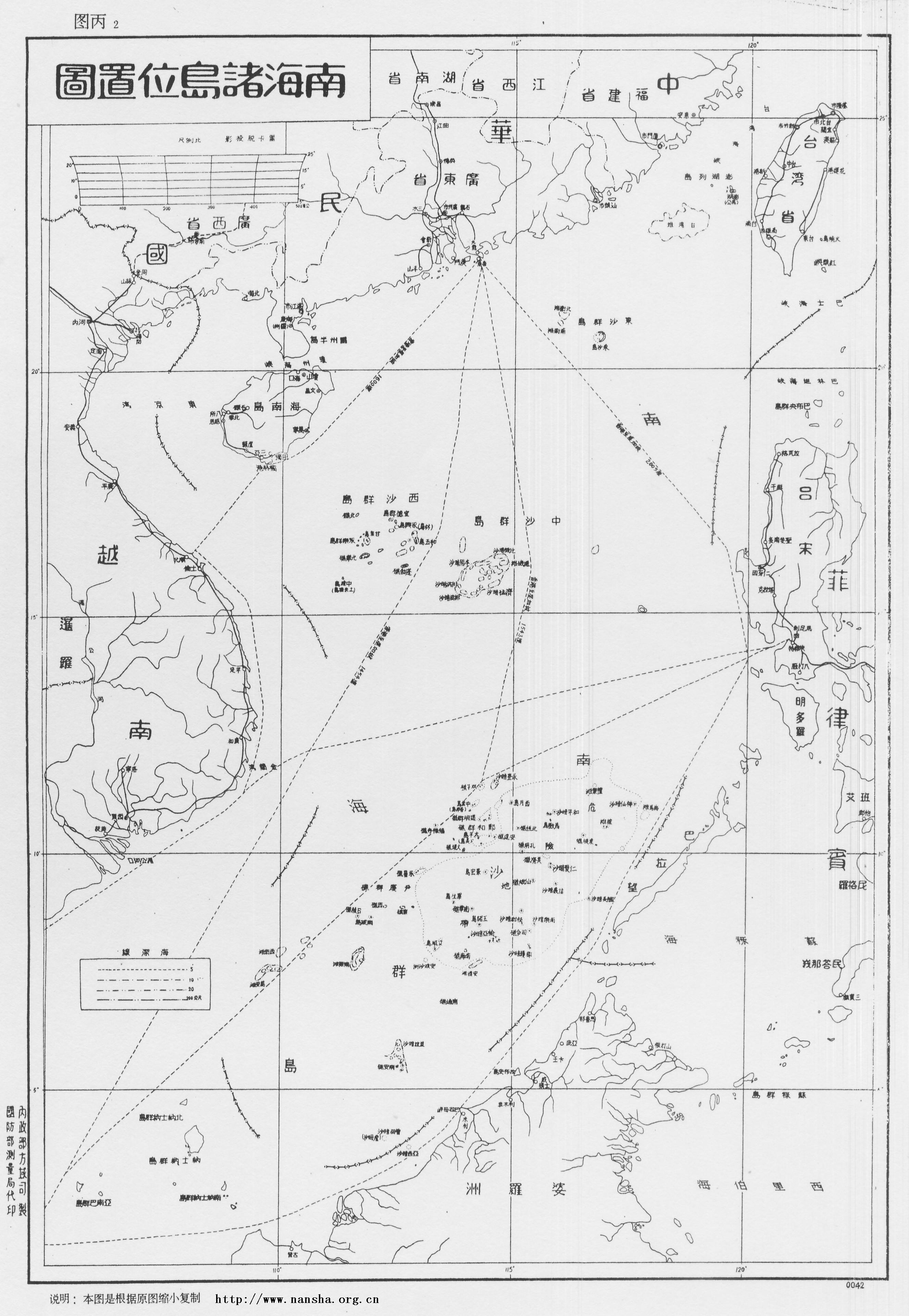
The Spratly Islands (; zh, s=南沙群岛, t=南沙群島, p=Nánshā Qúndǎo; ; ) are a disputed archipelago in the South China Sea. Composed of islands, islets, cays, and more than 100 reefs, sometimes grouped in submerged old atolls, the archipelago lies off the coasts of the Philippines, Malaysia, and southern Vietnam. Named after the 19th-century British whaling captain Richard Spratly who sighted Spratly Island in 1843, the islands contain less than of naturally occurring land area that is spread over hundreds of square km of the South China Sea. The Spratly Islands are one of the major archipelagos in the South China Sea which complicate governance and economics in this part of Southeast Asia due to their location in strategic shipping lanes. The islands are largely uninhabited, but offer rich fishing grounds and may contain significant oil and natural gas reserves, and as such are important to the claimants in their attempts to establish international bounda ... [...More Info...] [...Related Items...] OR: [Wikipedia] [Google] [Baidu] |
Reed Bank
Reed Tablemount (also referred to as Reed Bank, Recto Bank and several other names) is a large tablemount or guyot in the South China Sea north-east of Dangerous Ground and north-east of the Spratly Islands. It covers an area of , but with depths between only . The submerged but hydrocarbon-rich area includes Nares Bank and Marie Louise Bank. Although the Permanent Court of Arbitration ruled in 2016 that the area is within the Philippine exclusive economic zone, economic rights to the area continue to be disputed – mainly by the People's Republic of China – and exploitation of the hydrocarbon reserves by the Philippines were suspended in 2015. The tablemount is in the northeast quadrant of the Philippine's Kalayaan claimed territory, which also includes most of the north and east portions of the Spratly Islands. The area is located off the northwest coast of Palawan, north of Iroquois reef, Pennsylvania reef and the Southern reefs, and east of the northern part of ... [...More Info...] [...Related Items...] OR: [Wikipedia] [Google] [Baidu] |
Great Chagos Bank
The Great Chagos Bank, in the Chagos Archipelago, about south of Maldives, is the largest atoll structure in the world, with a total area of . Islands Despite its enormous size, the Great Chagos Bank is largely a submarine structure. There are only four emerging reefs, mostly located on the western rim of the atoll, except for lonely Nelson Island, which lies wholly isolated in the middle of the northern fringe. These reefs have eight individual low and sandy islands, with a total land area of about . All islands and their surrounding waters are a Strict Nature Reserve since 1998. The total length of the eastern and southern expanses of the bank, as well as the reefs in its central area, are wholly submerged. The islands of the Great Chagos Bank, starting clockwise from the south, are: * Danger Island (slightly more than long from North to South, by wide, land area , vegetated with palm trees up to high. * Eagle Islands ** Île Aigle (Eagle Island, vegetated with hig ... [...More Info...] [...Related Items...] OR: [Wikipedia] [Google] [Baidu] |
Little Bahama Bank
The Bahama Banks are the submerged carbonate platforms located in the archipelago of The Bahamas within the Lucayan Archipelago. The term is usually applied in referring to either the Great Bahama Bank around Andros Island, or the Little Bahama Bank of Grand Bahama Island and Great Abaco, which are the largest of the platforms, and the Cay Sal Bank. The three banks of the Turks and Caicos Islands, namely the Caicos Bank of the Caicos island group, the Turks Bank of the Turks island group, and the submerged Mouchoir Bank, and the two banks north of the Dominican Republic in Hispaniola, namely the submerged Silver Bank and Navidad Bank, are geographically and geologically part of the Lucayan Archipleago, which entire carbonate platform is often generally referred to as the ''Bahamas platform''. Geologic history and structure The limestone that comprises the Banks has been accumulating since at least the Cretaceous period, and perhaps as early as the Jurassic; today the tot ... [...More Info...] [...Related Items...] OR: [Wikipedia] [Google] [Baidu] |
New Caledonia
New Caledonia ( ; ) is a group of islands in the southwest Pacific Ocean, southwest of Vanuatu and east of Australia. Located from Metropolitan France, it forms a Overseas France#Sui generis collectivity, ''sui generis'' collectivity of the French Republic, a legal status unique in overseas France, and is enshrined in a dedicated chapter of the French Constitution. The archipelago, part of the Melanesia subregion, includes the main island of Grande Terre (New Caledonia), Grande Terre, the Loyalty Islands, the Chesterfield Islands, the Belep archipelago, the Isle of Pines (New Caledonia), Isle of Pines, and a few remote islets. The Chesterfield Islands are in the Coral Sea. French people, especially locals, call Grande Terre , a nickname also used more generally for the entire New Caledonia. Kanak people#Agitation for independence, Pro-independence Kanak parties use the name (''pron.'' ) to refer to New Caledonia, a term coined in the 1980s from the ethnic name of the indi ... [...More Info...] [...Related Items...] OR: [Wikipedia] [Google] [Baidu] |
Lansdowne Bank
Lansdowne Bank, sometimes called Landsdowne Bank, is an extensive submerged bank located between the main island of New Caledonia and the Chesterfield Islands, in the easternmost part of the Coral Sea. It covers an area of , p. 26 making it one of the largest banks of the world, has general depths of , and a largely sandy bottom. Two reefs mark the shallowest spots of the bank, but they are still submerged at low tide. Fairway Ridge, also called Fairway Plateau, is a submarine feature shown on some maps in that area. The Lansdowne Bank area marked is far larger than Fairway Plateau, but there are smaller, unnamed plateaus nearby. The Lansdowne Bank area, shown at the northeastern end of [...More Info...] [...Related Items...] OR: [Wikipedia] [Google] [Baidu] |
Georges Bank
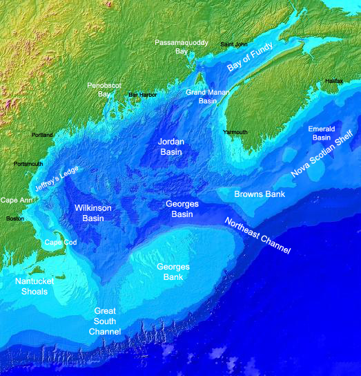
Georges Bank (formerly known as St. Georges Bank) is a large elevated area of the sea floor between Cape Cod, Massachusetts (United States), and Cape Sable Island, Nova Scotia (Canada). It separates the Gulf of Maine from the Atlantic Ocean. The origin of its name is obscure. The 1610 Velasco map, prepared for King James I of England, used the name "S. Georges Banck", a common practice when the name of the English patron saint, St. George, was sprinkled around the English-colonized world. By the 1850s, it was known simply as Georges Bank. Physical environment Georges Bank is the most westward of the great Atlantic fishing banks. The now-submerged portions of the North American mainland are comprised in the continental shelf running from the Grand Banks of Newfoundland to Georges. Georges Bank was part of the North American mainland as recently as 12,000 years ago. Roughly oval in shape, Georges Bank measures about in length by in width. Located offshore, Georges Bank i ... [...More Info...] [...Related Items...] OR: [Wikipedia] [Google] [Baidu] |
Seychelles Bank
The Mascarene Plateau is a submarine plateau in the Indian Ocean, north and east of Madagascar. The plateau extends approximately , from Seychelles in the north to Réunion in the south. The plateau covers an area of over of shallow water, with depths ranging from , plunging to to the abyssal plain at its edges. It is the second-largest oceanic plateau in the Indian Ocean after the Kerguelen Plateau. Geography The northern part of the Mascarene Plateau includes the Agaléga Islands and the Seychelles Islands. The southern part of the Mascarene Plateau includes Hawkins Bank, the Mascarene Islands, Nazareth Bank, the Saya de Malha Bank, and the Soudan Banks. The Mascarene Islands are the mountainous islands of the Cargados Carajos Shoals, Mauritius, Réunion, and Rodrigues. Geology The Indian subcontinent was at one time next to the east coast of Seychelles, but seafloor spreading has moved the landmass to its current position, where it has collided and fused with the c ... [...More Info...] [...Related Items...] OR: [Wikipedia] [Google] [Baidu] |
Saya De Malha
The Saya de Malha Bank (also the Sahia de Malha Bank, modern Portuguese: ''saia de malha'', English: ''mesh skirt'') or Mesh Skirt Bank, is one of the largest submerged ocean banks in the world, a part of the vast undersea Mascarene Plateau. Geography The Saya de Malha Bank lies northeast of Madagascar, southeast of Seychelles, and north of Nazareth Bank, the Cargados Carajos Shoals, and the island of Mauritius, and currently falls mostly under international waters. The closest land is tiny Agaléga (one of the Outer Islands of Mauritius), some further west, followed by the southern Seychellois island of Coëtivy, some northwest. Mauritius administers the whole Saya de Malha Bank as a portion of it lies within its exclusive economic zone. The bank covers an area of , and is composed of two separate structures, the smaller North Bank (also called Ritchie Bank), and the huge South Bank. If the South Bank were recognized as a submerged atoll structure, it would be the largest o ... [...More Info...] [...Related Items...] OR: [Wikipedia] [Google] [Baidu] |
Great Bahama Bank
The Bahama Banks are the submerged carbonate platforms located in the archipelago of The Bahamas within the Lucayan Archipelago. The term is usually applied in referring to either the Great Bahama Bank around Andros Island, or the Little Bahama Bank of Grand Bahama Island and Great Abaco, which are the largest of the platforms, and the Cay Sal Bank. The three banks of the Turks and Caicos Islands, namely the Caicos Bank of the Caicos island group, the Turks Bank of the Turks island group, and the submerged Mouchoir Bank, and the two banks north of the Dominican Republic in Hispaniola, namely the submerged Silver Bank and Navidad Bank, are geographically and geologically part of the Lucayan Archipleago, which entire carbonate platform is often generally referred to as the ''Bahamas platform''. Geologic history and structure The limestone that comprises the Banks has been accumulating since at least the Cretaceous period, and perhaps as early as the Jurassic; today the to ... [...More Info...] [...Related Items...] OR: [Wikipedia] [Google] [Baidu] |


