|
Nari District
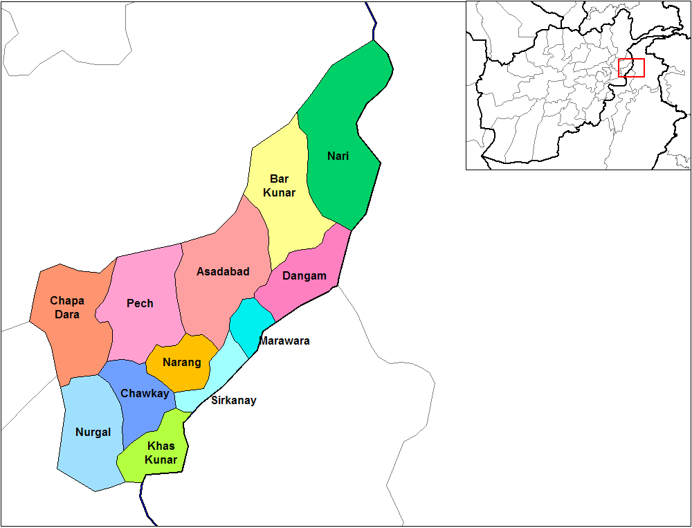
Nari District () is one of the districts of Kunar Province in eastern Afghanistan. It borders Bar Kunar District to the west, Nuristan Province to the north, Khyber Pakhtunkhwa to the east and Dangam district to the south. The population was reported in 2006 as 24,500 residents of which around 60% is ethnic Pashtun and the remaining 40% is Pashai and others. The district center is the village of Nari at 1153 m altitude in a river valley. The arable land is not enough. The residents usually collect wood and beans and sell them. Residents of Nari District have become victims of the Afghanistan–Pakistan border skirmishes in the past. See also *Districts of Afghanistan *Valleys of Afghanistan References External links *District Profile |
Provinces Of Afghanistan
The provinces of Afghanistan ( ''Wilayah, wilāyat'') are the primary administrative divisions. Afghanistan is divided into 34 provinces. Each province encompasses a number of Districts of Afghanistan, districts or usually over 1,000 villages. Provincial governors played a critical role in the reconstruction of the Afghan state following the creation of the new government under Hamid Karzai. According to international security scholar Dipali Mukhopadhyay, many of the provincial governors of the western-backed government were former warlords who were incorporated into the political system. Provinces of Afghanistan Administrative The following table lists the province, capital, number of districts, UN region, region, ISO 3166-2:AF code and license plate code. Demographic The following table lists the province, population in 2024, area in square kilometers and population density. Regions of Afghanistan The following tables summarize data from the demographic ... [...More Info...] [...Related Items...] OR: [Wikipedia] [Google] [Baidu] |
Dangam District
Dangam District is situated in the eastern end of Kunar Province in Afghanistan. It borders Marawara district to the southwest, Asadabad district to the west, Bar Kunar district to the north, Nari district to the northeast and Khyber Pakhtunkhwa in Pakistan to the east. The district is mountainous, but it is also economically underdeveloped. The population of Dangam is approximately 18,803 (2019). Of this, around 98% are Pashtuns and the remaining 2% are Tajiks. There are 50 sub-villages and the district center is Dangam () at 1356 m altitude, located in the central part of the district. Dangam and the region in general has been known for military actions against militant groups. It was reported in 2018 that Pakistani military The Pakistan Armed Forces (; ) are the Military, military forces of Pakistan. It is the List of countries by number of military and paramilitary personnel, world's sixth-largest military measured by Active duty, active military personnel and c ... e ... [...More Info...] [...Related Items...] OR: [Wikipedia] [Google] [Baidu] |
Valleys Of Afghanistan
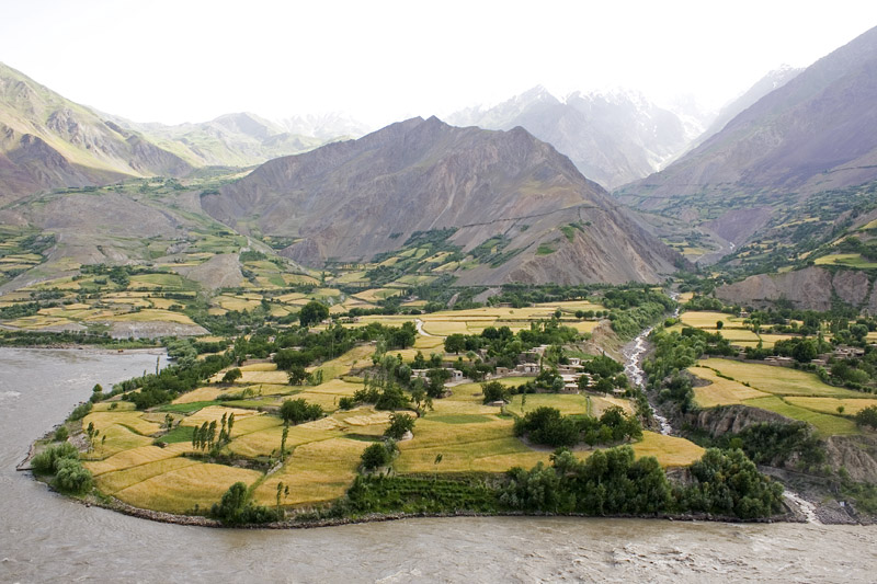
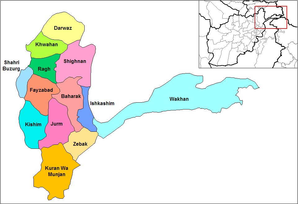
Afghanistan, which is about two-thirds mountainous, contains many valleys. The majority of the valleys are located in parts of northeastern, central, southern and southeastern Afghanistan. The southeastern areas are wetter and are covered by forest with trees such as cypress, oak, populus, poplar, pine etc. The valleys are the most populated regions in the country, and much of the agriculture done takes place either in the valleys or on the high plains. Wakhan Valleys in the Wakhan include: * Sheghnan Valley * Ashava Valley * Darwaz Valley * Drayem Valley * Arsj Valley * Hnjab Valley * Farkhar Valley * Ishkamish District Valley (see Ishkamish District) * Khost i Fereng Valley * Samandan Valley * Andrab Valley * Khenjan Valley * Tala wa Barfak Valley (see Tala wa Barfak District) Southern Hindu Kush Southern Hindu Kush valleys include (among others): * Panj Valley Valley * Korm Valley * Panjdarh Nijrab Valley * Bandavol Valley * Eshpi Valley * Shishil Valley * Kepchaq Valley * ... [...More Info...] [...Related Items...] OR: [Wikipedia] [Google] [Baidu] |
Districts Of Afghanistan
The districts of Afghanistan, known as ''wuleswali'' (, ''wuləswāləi''; , ''wuləswālī''; ''ulasvolik''), are secondary-level administrative units, one level below Provinces of Afghanistan, provinces. The Afghan government issued its first district map in 1973. It recognized 325 districts, counting ''wuleswalis'' (districts), ''alaqadaries'' (sub-districts), and ''markaz-e-wulaiyat'' (provincial center districts). In the ensuing years, additional districts have been added through splits, and some eliminated through merges. In June 2005, the Afghan government issued a map of 398 districts. It was widely adopted by many information management systems, though usually with the addition of ''Sharak-e-Hayratan'' for 399 districts in total. It remains the ''de facto'' standard as of late 2018, despite a string of government announcements of the creation of new districts. The latest announced set includes 421 districts. The country's Central Statistics Office (CSO) and the Indepe ... [...More Info...] [...Related Items...] OR: [Wikipedia] [Google] [Baidu] |
Arable Land
Arable land (from the , "able to be ploughed") is any land capable of being ploughed and used to grow crops.''Oxford English Dictionary'', "arable, ''adj''. and ''n.''" Oxford University Press (Oxford), 2013. Alternatively, for the purposes of agricultural statistics, the term often has a more precise definition: A more concise definition appearing in the Eurostat glossary similarly refers to actual rather than potential uses: "land worked (ploughed or tilled) regularly, generally under a system of crop rotation". In Britain, arable land has traditionally been contrasted with pasturable land such as heaths, which could be used for sheep-rearing but not as farmland. Arable land is vulnerable to land degradation and some types of un-arable land can be enriched to create useful land. Climate change and biodiversity loss are driving pressure on arable land. By country According to the Food and Agriculture Organization of the United Nations, in 2013, the world's arable land amo ... [...More Info...] [...Related Items...] OR: [Wikipedia] [Google] [Baidu] |
Pashayi People
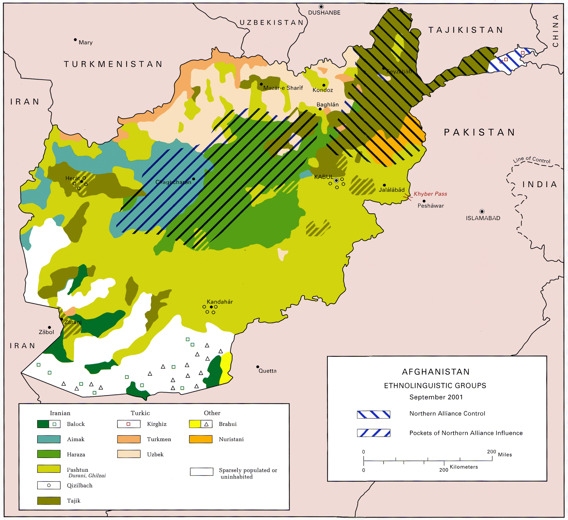
The Pashayi or Pashai, formerly known as the Alina, ( /pəˈʃaɪ/; Pashayi: پشهای, romanised: ''Paṣhəy'') are an Indo-Aryan ethnolinguistic group living primarily in eastern Afghanistan. They are mainly concentrated in the northern parts of Laghman and Nangarhar, also parts of Kunar, Kapisa, Parwan, Nuristan, and a bit of Panjshir. Many Pashai are bilingual in Pashto and sometimes trilingual with Farsi as a third language. Some of the Pashayi have been assimilated by Pashtuns, whereas those in Panjshir and Parwan, have been assimilated by Tajiks. Some Pashayi people are also based in Central Afghanistan, in places such as Jaghori District. History There is no consensus on the origins of the Pashayi. According to Christine Noelle-Karimi, the Pashayis and Nuristanis were native to the Kunar Valley and Laghman Province, near Jalalabad in north-east Afghanistan, until they were displaced to less fertile mountainous region by successive waves of immigration by ... [...More Info...] [...Related Items...] OR: [Wikipedia] [Google] [Baidu] |
Pashtun People
Pashtuns (, , ; ;), also known as Pakhtuns, or Pathans, are an Iranic ethnic group primarily residing in southern and eastern Afghanistan and northwestern Pakistan. They were historically also referred to as Afghans until 1964 after the term's meaning had become a demonym for all citizens of Afghanistan regardless of their ethnic group. The Pashtuns speak the Pashto language, which belongs to the Eastern Iranian branch of the Iranian language family. Additionally, Dari serves as the second language of Pashtuns in Afghanistan, while those in Pakistan speak Urdu and English. In India, the majority of those of Pashtun descent have lost the ability to speak Pashto and instead speak Hindi and other regional languages. There are an estimated 350–400 Pashtun tribes and clans with a variety of origin theories. In 2021, Shahid Javed Burki estimated the total Pashtun population to be situated between 60 and 70 million, with 15 million in Afghanistan. Others who accept the ... [...More Info...] [...Related Items...] OR: [Wikipedia] [Google] [Baidu] |
Khyber Pakhtunkhwa
Khyber Pakhtunkhwa (; ; , ; abbr. KP or KPK), formerly known as the North West Frontier Province (NWFP), is a Administrative units of Pakistan, province of Pakistan. Located in the Northern Pakistan, northwestern region of the country, Khyber Pakhtunkhwa is the fourth largest province of Pakistan by land area and the third-largest province by population. It is bordered by Balochistan, Pakistan, Balochistan to the south; Punjab, Pakistan, Punjab, Islamabad Capital Territory, and Azad Kashmir to the east; and Gilgit-Baltistan to the north and northeast. It shares an Durand Line, international border with Afghanistan to the west. Khyber Pakhtunkhwa has a varied geography of rugged mountain ranges, valleys, rolling foothills, and dense agricultural farms. While it is the third-largest Pakistani province in terms of both its population and Economy of Khyber Pakhtunkhwa, its economy, it is geographically the smallest. Khyber Pakhtunkhwa's share of Pakistan's GDP has historically com ... [...More Info...] [...Related Items...] OR: [Wikipedia] [Google] [Baidu] |
Kunar Province
Kunar (Pashto: ; Dari: ) is one of the 34 provinces of Afghanistan, located in the northeastern part of the country. Its capital is Asadabad. Its population is estimated to be 508,224. Kunar's major political groups include Wahhabis or Ahl-e- Hadith, ''Nazhat-e Hambastagi Milli, Hezb-e Afghanistan Naween, Hezb-e Islami Gulbuddin''. It is one of the four " N2KL" provinces (Nangarhar Province, Nuristan Province, Kunar Province and Laghman Province). N2KL was the designation used by the US and Coalition Forces in Afghanistan for the rugged region along the Afghanistan–Pakistan border opposite Pakistan's Federally Administered Tribal Areas (merged in 2018 with Khyber Pakhtunkhwa). Kunar is the center of the N2KL region. Kunar, along with Nuristan, was part of the borderlands known as Kafiristan, and until a few decades ago, it was never considered a true part of Afghanistan. Kunar is a sparsely populated, mountainous, forested border area. Geography Kunar province is loca ... [...More Info...] [...Related Items...] OR: [Wikipedia] [Google] [Baidu] |
Nuristan Province
Nuristan, also spelled as Nurestan or Nooristan (Pashto: ; Katë: ), is one of the 34 provinces of Afghanistan, located in the eastern part of the country. It is divided into seven districts and is Afghanistan's least populous province, with a population of around 167,000. Parun serves as the provincial capital. Nuristan is bordered on the south by Laghman and Kunar provinces, on the north by Badakhshan province, on the west by Panjshir province, and on the east by Pakistan. The origin of the local Nuristani people has been disputed, ranging from being the indigenous inhabitants forced to flee to this region after refusing to surrender to invaders, to being linked to various ancient groups of people and the Turk Shahi kings. Some Nuristanis claim being descendants of the Greek occupying forces of Alexander the Great. It was formerly called Kafiristan () ("Land of the Infidels") until the inhabitants were forcibly converted from an animist religion with elements from In ... [...More Info...] [...Related Items...] OR: [Wikipedia] [Google] [Baidu] |
Bar Kunar District
Bar Kunar District is situated in the northeastern part of Kunar Province, Afghanistan. It borders Asadabad district to the southwest, Nuristan Province to the northwest, Nari district to the northeast and Dangam district to the southeast. The population is 19,500 (2006) - all Pashtun. The district center is the village of Asmãr () at 983 m elevation in a river valley, located in the most southern part of the district.The district is mountainous and the arable land Arable land (from the , "able to be ploughed") is any land capable of being ploughed and used to grow crops.''Oxford English Dictionary'', "arable, ''adj''. and ''n.''" Oxford University Press (Oxford), 2013. Alternatively, for the purposes of a ... is not enough and people are poor. It is said that the fight against the Soviet Army started in this district External linksAIMS District Map Districts of Kunar Province {{Kunar-geo-stub ... [...More Info...] [...Related Items...] OR: [Wikipedia] [Google] [Baidu] |


