|
Muscatine, Iowa Micropolitan Area
The Muscatine Micropolitan Statistical Area, as defined by the United States Census Bureau, is an area consisting solely of Muscatine County, Iowa, Muscatine County and anchored by the city of Muscatine, Iowa, Muscatine. The Muscatine Micropolitan Statistical Area is also a part of the Quad Cities, Quad Cities Iowa–Illinois Combined Statistical Area (CSA), which has a population of 474,226, making it the 90th-largest List of Combined Statistical Areas, CSA in the nation. As of the United States Census, 2000, 2000 census, the area had a population of 53,905 (though a July 1, 2009 estimate placed the population at 54,179). Counties *Muscatine County, Iowa, Muscatine Communities Places with more than 20,000 inhabitants *Muscatine, Iowa, Muscatine (Principal city) Places with 1,000 to 5,000 inhabitants *Columbus Junction, Iowa, Columbus Junction *Wapello, Iowa, Wapello *West Liberty, Iowa, West Liberty *Wilton, Iowa, Wilton (partial) Places with 500 to 1,000 inhabitants *Fruitlan ... [...More Info...] [...Related Items...] OR: [Wikipedia] [Google] [Baidu] |
Muscatine County, Iowa
Muscatine County is a County (United States), county located in the U.S. state of Iowa. As of the 2020 United States census, 2020 census, the population was 43,235. The county seat is Muscatine, Iowa, Muscatine. The southeastern border is formed by the Mississippi River. Muscatine County comprises the Muscatine, IA Muscatine micropolitan area, Micropolitan Statistical Area, which is included in the Davenport, Iowa, Davenport-Moline, Illinois, Moline, IA-Illinois, IL Quad Cities Metropolitan Area, Combined Statistical Area. History Muscatine County was formed in December 1836 as a part of Wisconsin Territory, partitioned from Des Moines County, Iowa, Des Moines County, which had been organized two years previously. One history suggests that the county was named for Muscatine Island in the Mississippi River. The island lies opposite Muscatine County and was believed to be named after the Mascouten tribe, Algonquian-speaking Indigenous peoples of the Americas, Native Americans who ... [...More Info...] [...Related Items...] OR: [Wikipedia] [Google] [Baidu] |
Atalissa, Iowa
Atalissa is a city in Muscatine County, Iowa, United States. The population was 296 at the 2020 census. It is part of the Muscatine Micropolitan Statistical Area. History Atalissa was platted in 1859. It was named by its founder, William Lundy, for a mining town in California, which in turn was named for an Indian queen Atalissa. From 1974 to 2009 Atalissa was the home of a few dozen intellectually challenged men who worked in a nearby turkey processing plant. They lived together in an old schoolhouse and were taken each workday to the plant, and after expenses were taken out, were paid no more than $65/month. They were removed and relocated by state agencies in 2009, after being found to be living in unacceptable conditions. A 2013 verdict awarded the men a total of $240 million in damages, since reduced to $50,000/man. The men's plight had a profound effect on social services in Iowa, and their experiences and subsequent court case was the subject of the documentary film ' ... [...More Info...] [...Related Items...] OR: [Wikipedia] [Google] [Baidu] |
Morning Sun, Iowa
Morning Sun is a city in Morning Sun Township, Louisa County, Iowa, United States. The population was 752 at the time of the 2020 census. It is part of the Muscatine Micropolitan Statistical Area. History Morning Sun was laid out in 1851 by Cicero Hamilton. Geography Morning Sun is located on the north side of Iowa Highway 78 approximately 1.5 miles north of the Louisa-Des Moines county line. Wapello is about six miles north. According to the United States Census Bureau, the city has a total area of , all land. Demographics 2020 census As of the census of 2020, there were 752 people, 286 households, and 199 families residing in the city. The population density was 967.7 inhabitants per square mile (373.6/km2). There were 316 housing units at an average density of 406.6 per square mile (157.0/km2). The racial makeup of the city was 93.6% White, 0.3% Black or African American, 0.5% Native American, 0.1% Asian, 0.0% Pacific Islander, 1.6% from other races and 3.9% from ... [...More Info...] [...Related Items...] OR: [Wikipedia] [Google] [Baidu] |
Grandview, Iowa
Grandview is a city in Louisa County, Iowa, United States. The population was 437 at the time of the 2020 United States census, 2020 census. It is part of the Muscatine, Iowa, Muscatine Muscatine micropolitan area, Micropolitan Statistical Area. History Grandview was laid out in 1841 by Alvin Clark and Robert Childers. Grandview was Tornadoes of 2007#June 1, seriously affected by an Enhanced Fujita Scale, EF3 tornado on June 1, 2007, which damaged or destroyed dozens of houses and impacted other parts of the city. Geography Grandview is located one half mile east of the junction of US Route 61 and Iowa Highway 92. Wapello, Iowa, Wapello is six miles to the south and Muscatine, Iowa, Muscatine is approximately 12 miles to the northeast. According to the United States Census Bureau, the city has a total area of , all land. Demographics 2020 census As of the United States census, census of 2020, there were 437 people, 186 households, and 109 families residing in the city. The ... [...More Info...] [...Related Items...] OR: [Wikipedia] [Google] [Baidu] |
Fruitland, Iowa
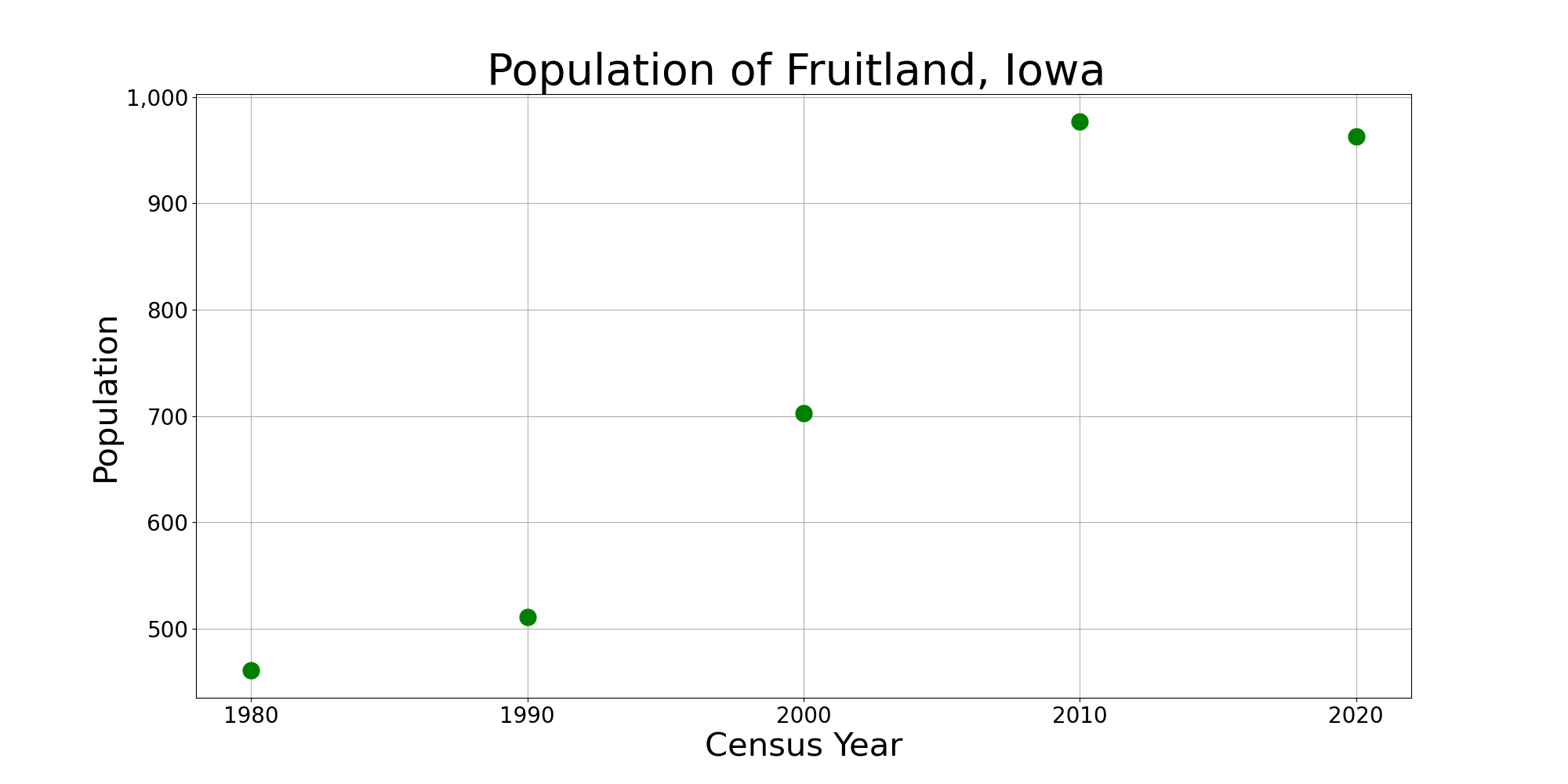
Fruitland is a city in Muscatine County, Iowa, United States. The population was 963 at the time of the 2020 census. It is part of the Muscatine Micropolitan Statistical Area. Geography According to the United States Census Bureau, the city has a total area of , all land. Demographics 2020 census As of the census of 2020, there were 963 people, 337 households, and 280 families residing in the city. The population density was 534.5 inhabitants per square mile (206.4/km2). There were 346 housing units at an average density of 192.1 per square mile (74.2/km2). The racial makeup of the city was 92.6% White, 0.5% Black or African American, 0.0% Native American, 0.0% Asian, 0.0% Pacific Islander, 2.3% from other races and 4.6% from two or more races. Hispanic or Latino persons of any race comprised 6.3% of the population. Of the 337 households, 41.5% of which had children under the age of 18 living with them, 68.0% were married couples living together, 7.1% were cohabitating ... [...More Info...] [...Related Items...] OR: [Wikipedia] [Google] [Baidu] |
Wilton, Iowa
Wilton (formerly Wilton Junction) is a city in Cedar and Muscatine counties in the U.S. state of Iowa. The population was 2,924 at the time of the 2020 census. The Muscatine County portion of Wilton is part of the Muscatine Micropolitan Statistical Area. History The first settler to build a home in the area that was to be known as Wilton in the new state of Iowa (1846) was Mr. Christian Marolf who came in July 1849, and erected of a small log house opposite the German Lutheran church. When he built his home Mr. Marolf could only see the home of Mr. Stearns just west of town on the south side of the Moscow road. Mr. Marolf was soon followed by Mr. Ben Maurer in 1850 whose land now comprises North Wilton and Peter Marolf in 1851, which is now known as Marolf's addition. North Wilton is at present (1947) not within the corporate limits of Wilton. The city was once home to the Wilton German English College from 1894 to 1905. The campus of the college was later turned into Cit ... [...More Info...] [...Related Items...] OR: [Wikipedia] [Google] [Baidu] |
West Liberty, Iowa
West Liberty is a city in Muscatine County, Iowa, United States. The population was 3,858 at the time of the 2020 census. It is part of the Muscatine micropolitan area. West Liberty is located five miles south of Interstate 80 on Historic Highway 6. The city is home to the West Liberty Raceway, located in the Muscatine County Fairgrounds. The Muscatine County Fair takes place in West Liberty in July of each year. History West Liberty was incorporated in 1868, at the junction of the Chicago, Rock Island and Pacific and Burlington, Cedar Rapids and Northern Railroads. Prior to incorporation, the town stood about a half-mile north of its current location, but was relocated to be closer to the railway. The settlement was originally called Wapsinonoc Township, which means smooth surfaced, meandering creek or stream. The name change to Liberty (after Liberty, Ohio, the former home of many of its settlers) is attributed to the wife of the township's first postmaster, Simeon A. Bag ... [...More Info...] [...Related Items...] OR: [Wikipedia] [Google] [Baidu] |
Wapello, Iowa
Wapello is a city in and the county seat of Louisa County, Iowa, United States. The population was 2,084 at the time of the 2020 census. Wapello is part of the Muscatine Micropolitan Statistical Area. History Wapello was platted in the late 1830s. The city's namesake is Wapello, a Meskwaki chief. Geography Wapello is located on the west side of the Iowa River. US Route 61 passes through the community. According to the United States Census Bureau, the city has a total area of , of which is land and is water. Wapello is on the Iowa River. Demographics 2020 census As of the census of 2020, there were 2,084 people, 837 households, and 543 families residing in the city. The population density was 1,664.0 inhabitants per square mile (642.5/km2). There were 900 housing units at an average density of 718.6 per square mile (277.5/km2). The racial makeup of the city was 86.6% White, 0.8% Black or African American, 0.6% Native American, 0.3% Asian, 0.0% Pacific Islander, 5. ... [...More Info...] [...Related Items...] OR: [Wikipedia] [Google] [Baidu] |
Columbus Junction, Iowa
Columbus Junction is a city in Louisa County, Iowa. The population was 1,830 at the 2020 census. It is part of the Muscatine Micropolitan Statistical Area. Columbus Junction is home of the historic Swinging Bridge, found one block south of Highway 92 near downtown. The 262-foot-long steel cable and wood suspension bridge was built in 1922 as an elevated walkway connecting Third and Fourth streets. The Columbus Community School District (which serves Columbus Junction, Columbus City, Fredonia, Cotter, Conesville, and other surrounding townships) is based in Columbus Junction. The school's colors are blue and white and their mascot is a wildcat. The city's largest employer is a Tyson Foods meat processing plant located just north of the city on Highway 70. History Columbus Junction began as a settlement located at the intersection of two railroad lines. The Chicago, Rock Island and Pacific Railroad (also known as the Rock Island ine built an east–west line through the ar ... [...More Info...] [...Related Items...] OR: [Wikipedia] [Google] [Baidu] |
Comma-separated Values
Comma-separated values (CSV) is a text file format that uses commas to separate values, and newlines to separate records. A CSV file stores Table (information), tabular data (numbers and text) in plain text, where each line of the file typically represents one data record (computer science), record. Each record consists of the same number of field (computer science), fields, and these are separated by commas in the CSV file. If the field delimiter itself may appear within a field, fields can be surrounded with quotation marks. The CSV file format is one type of Delimiter-separated values, delimiter-separated file format. Delimiters frequently used include the comma, tab-separated values, tab, space, and semicolon. Delimiter-separated files are often given a ".csv" filename extension, extension even when the field separator is not a comma. Many applications or libraries that consume or produce CSV files have options to specify an alternative delimiter. The lack of adherence to the ... [...More Info...] [...Related Items...] OR: [Wikipedia] [Google] [Baidu] |


