|
List Of Tributaries Of The Yangtze
The Yangtze has a number of direct tributaries. This page lists such tributaries by size, from the estuary upwards in the order of their inflows. Tributaries with a Drainage basin, drainage area greater than 1,000 km2 and a Discharge regime, flow rate greater than 10 m3/s are included. *Period: 1971–2000 References {{reflist Yangtze River Tributaries of the Yangtze River, * Lists of river tributaries, Yangtze ... [...More Info...] [...Related Items...] OR: [Wikipedia] [Google] [Baidu] |
Yangtze
The Yangtze or Yangzi ( or ) is the longest river in Eurasia and the third-longest in the world. It rises at Jari Hill in the Tanggula Mountains of the Tibetan Plateau and flows including Dam Qu River the longest source of the Yangtze, in a generally easterly direction to the East China Sea. It is the fifth-largest primary river by discharge volume in the world. Its drainage basin comprises one-fifth of the land area of China, and is home to nearly one-third of the country's population. The Yangtze has played a major role in the history, culture, and economy of China. For thousands of years, the river has been used for water, irrigation, sanitation, transportation, industry, boundary-marking, and war. The Yangtze Delta generates as much as 20% of China's GDP, and the Three Gorges Dam on the Yangtze is the largest hydro-electric power station in the world. In mid-2014, the Chinese government announced it was building a multi-tier transport network, comprising railway ... [...More Info...] [...Related Items...] OR: [Wikipedia] [Google] [Baidu] |
Sheshui
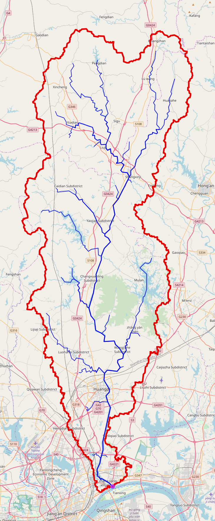
The She River (''She'' pronounced like "shuh"), also known by its Chinese name Sheshui, is a left tributary of the Yangtze in central China. It has a length of 112 km.《辞海》2009年. pp.2000 The route of the She River was noted in the Commentary on the Water Classic. It is the namesake of Shekou in Huangpi District, Wuhan. Shekouxincheng Station is located near the mouth of the She River. Geography The headwaters of the She River flow from Mount Sanjiao ('Triangle Mountain') in Dawu County, Hubei in Xiaogan. The river then travels east across Hong'an County in Huanggang, then entering the Huangpi District of Wuhan. Its watershed area is roughly rectangular in shape. On the lower reaches of the She River, there are several archaeological sites including the Masai archaeological site dating from the Warring States period, the Chengmentan archaeological site (New Stone Age), and the Sangujing archaeological site. ''Warm Winter on the She River'' The ''Warm Winter ... [...More Info...] [...Related Items...] OR: [Wikipedia] [Google] [Baidu] |
Tuo River
The Tuo River () is -long river in Sichuan province of southern China. The Tuo River is one of the major tributaries of the upper Yangtze River (''Chang Jiang''). Geography The river originates at the northwest edge of Sichuan basin. It flows through Jintang, Jianyang, Ziyang, Zizhong, and Neijiang. It flows into Yangtze River in Luzhou, Sichuan. See also * Index: Tributaries of the Yangtze River * List of rivers in China References *Great Soviet Encyclopedia The ''Great Soviet Encyclopedia'' (GSE; , ''BSE'') is one of the largest Russian-language encyclopedias, published in the Soviet Union from 1926 to 1990. After 2002, the encyclopedia's data was partially included into the later ''Great Russian Enc ... {{coord, 28.9036, N, 105.448, E, source:kolossus-dewiki, display=title Rivers of Sichuan Tributaries of the Yangtze River ... [...More Info...] [...Related Items...] OR: [Wikipedia] [Google] [Baidu] |
Chishui River
Chishui River (; historically, Huainanzi"Lecture on Terrains"quote: "何謂六水?曰河水、赤水、遼水、黑水、江水、淮水。") is a major tributary of the upper Yangtze. Its name literally means "red water river"/"red river" because it shows reddish color in lower stream due to a large sediment concentration. With the source in Yunnan Province, it forms part of the boundary between the provinces of Guizhou and Sichuan and flows into Yangtze River in Sichuan. It is sometimes called the River of Wines since there are several types of famous Chinese wines, including Lang Wine, Xi Wine and Maotai, originated along the river. It is also known as the field of a major battle ( the Four Crossing of Chishui) commanded by Mao Zedong in 1935 during the Long March of the Red Army The Workers' and Peasants' Red Army, often shortened to the Red Army, was the army and air force of the Russian Soviet Republic and, from 1922, the Soviet Union. The army was establishe ... [...More Info...] [...Related Items...] OR: [Wikipedia] [Google] [Baidu] |
Qi River (tributary Of Yangtze River)
Qi River () is a river in southwest China's Guizhou and Chongqing. It is long and is a tributary of Yangtze River, draining an area of . It rises in northwestern Guizhou's Tongzi County, and flows generally north, passing through the center of Chongqing and joining the Yangtze River in of Jiangjin District. Qi River flows through Tongzi County and Xishui County of Guizhou Province and Qijiang District, Jiangjin District, Nanchuan District and Banan District of Chongqing City. Qi River's main tributaries include Xiangma River (), Qixi River (), Yangdu River (), Zaodu River (), Tonghui River (), Sunxi River (), and Wenshui River (). History At 20:00 p.m. on June 22, 2020, the "Qijiang Wucha Hydrological Station" () in recorded a water level of , which was higher than the guaranteed water level (). The Qijiang Wucha Hydrological Station reached , topping the previous record of in 1998 China floods The 1998 China floods (1998年中国洪水) lasted from middle of June to th ... [...More Info...] [...Related Items...] OR: [Wikipedia] [Google] [Baidu] |
Jialing River
The Jialing River, formerly known by numerous other names, is a major tributary of the Yangtze River in the Sichuan Basin. It is named after the Jialing Valley in Feng County, Shaanxi through which it flows. The Jialing River's most notable characteristic was formerly its pellucid green waters. It is also notable for its sinuous course in its lower reaches. From Zhangwang Miao (Temple of Zhangfei) in Langzhong to the mouth, the distance as the crow flies is . However the river itself travels . The most tortuous part of its course is between Nanchong and Wusheng County. Names The name Jialing did not come into general use until the Tang Dynasty.. Before that, it was generally known as the Ba, although it also appears as the Lang and Yu as well. In the 19th century, it was known by the Sichuanese as the Small or Little River, by comparison with the Jinsha and Yangtze. Geography The source of the Jialing, in name, is in the Jialin, which means "the tomb of Jia (嘉陵 ... [...More Info...] [...Related Items...] OR: [Wikipedia] [Google] [Baidu] |
Wu River (Yangtze Tributary)
The Wu River () is the largest southern tributary of the Yangtze River. Nearly its entire length of runs within the isolated, mountainous and ethnically diverse province of Guizhou. The river takes drainage from a watershed. The river flows through the Liupanshui, Anshun, Guiyang (the capital), Qiannan, and Zunyi Districts of Guizhou. All nine regions of the province have at least partial drainage to the river. Course The river begins as the ''Sancha'' in western Guizhou and flows eastwards about . It then bends north, west and south in a reach called the Yachi, and receives the Nanming River from the right. After the Yachi reach, the Wu makes a broad arc northeast through central Guizhou, picking up fifteen major tributaries including the Yu, Furong and Ya Rivers and flowing through several large hydroelectric dams. It then crosses the border into the provincial-level municipality of Chongqing, flows past Wulong, and empties into the Yangtze River at Fuling, some east-n ... [...More Info...] [...Related Items...] OR: [Wikipedia] [Google] [Baidu] |
Xiao River
The Xiao River ( zh, c=瀟水, p=Xiāoshuǐ ) is the Main Stream of the upper Xiang River located in Yongzhou, Hunan. As of 2011 Water Census of China, it has a length of from the headwaters to the confluence in the Ping Island of Yongzhou with the Xiang River West Branch (Left Branch) originating from Guangxi. With the tributaries, its drainage basin area is .As of 2011 Water Census of China, the Xiao River was identified as the Main Stem of the Upper Xiang River. 湘江源头在湖南蓝山, 湘江干流全长948公里, 流域面积94,721平方公里 - The source stream of the Xiang is in Lanshan County, the main river of the Xiang has a length of with a drainage basin area of rough , according thn.xinhuanet.como/ref> Night rain on the Xiaoxiang ( ), one of the Eight Views of Xiaoxiang, is located in this river. Geography The Xiao River borders to the south by the Mengzhu Mountains and Gui River of Xi River tributary, to the east by ''Yangming Mountains'' (阳明山), Chongling ... [...More Info...] [...Related Items...] OR: [Wikipedia] [Google] [Baidu] |
Meixi River Bridge
The Meixi River Bridge is an arch bridge which crosses the Meixi River in Fengjie, Chongqing, China. It replaced an earlier suspension bridge across the river built in 1990. Completed in 2000, The bridge was constructed above the river however the reservoir created by the construction of the Three Gorges Dam has increased the height of the water below the bridge and the full clearance is no longer visible. The bridge spans ranking among the longest arch bridges in the world. The bridge is located very near the end of the river and can be seen by boats travelling along the Yangtze River. See also *List of longest arch bridge spans This list of the longest arch bridge spans ranks the world's arch bridges by the length of their main Span (architecture), span. The length of the main span is the most common way to rank bridges as it usually correlates with the engineering compl ... * Meixi River Expressway Bridge External links *https://web.archive.org/web/20121113220849/http://hi ... [...More Info...] [...Related Items...] OR: [Wikipedia] [Google] [Baidu] |
Daning River Bridge
The Daning River Bridge is an arch bridge near Wushan, Chongqing, China. The bridge opened in 2009 carrying traffic on the G42 Shanghai–Chengdu Expressway across the Daning River. The bridge spans making it one of the longest arch bridges in the world. The bridge is also among the highest in the world however the reservoir created by the construction of the Three Gorges Dam has increased the height of the river below the bridge and the full clearance is no longer visible. See also *List of longest arch bridge spans *List of highest bridges in the world This list of highest bridges includes bridges with a deck height of at least . The of a bridge is the maximum vertical drop distance between the bridge deck (the road, rail or other transport bed of a bridge) and the ground or water surface ben ... External linksDaninghe Bridge Hurong - highestbridges.com References Bridges in Chongqing Arch bridges in China Bridges completed in 2009 {{PRChina-bridge-struc ... [...More Info...] [...Related Items...] OR: [Wikipedia] [Google] [Baidu] |
Huangbai River
The Huangbai River or Huangbo River () is a river in China's Hubei Province, a left tributary of the Yangtze River. The Huangbai is located entirely within the prefecture-level city of Yichang. It flows in a southern direction through Yichang's Yiling District and Yuan'an County, to its confluence with the Yangtze, immediately upstream of the Gezhouba Dam. The water level in the river has been raised by the dam, the lowermost section of the river is now somewhat of a harbor on the Gezhouba Reservoir, with numerous wharves and shipyards. The Chinese Sturgeon Museum, part of the Chinese Sturgeon Research Center, is located on a small island called Xiaoxita in the Huangbai River, within Yiling District Yiling District () is a district of the prefecture-level city of Yichang, Hubei province, People's Republic of China. Created on July 30, 2001, the district includes most of the former Yichang County, with the exception of Yichang center city (whi .... References {{coord missi ... [...More Info...] [...Related Items...] OR: [Wikipedia] [Google] [Baidu] |
Qing River
The Qing River () is a right (southern) tributary of the Yangtze River, Yangtze River (Chang Jiang) in Hubei province of south-central China., Geography Course The Qing River river source, Headwaters originate at Teng Long Dong, Tenglong Cave (Teng Long Dong) near Lichuan, Hubei, Lichuan City, in Hubei's southwestern corner. The river is long. Its drainage divide, drainage area is , occupying large portions of the Enshi Tujia and Miao Autonomous Prefecture and Yichang Prefecture-level city. The Qing River (Qing Jiang) confluence with the Yangtze River (Chang Jiang) is at the ancient city of Yidu, Hubei, Yidu in the Yichang Prefecture of Hubei. Dams The Qing River has three large dams on it: the Geheyan Dam, Gaobazhou Dam, and Shuibuya Dam. The Geheyan Dam has a Ship lifts in China, ship lift that can lift vessels of up to 300 tons displacement, to allow water transport upriver from the dam. During the 1998 Yangtze River floods the dam effectively held back the Qing River ... [...More Info...] [...Related Items...] OR: [Wikipedia] [Google] [Baidu] |


