|
List Of Rivers Of Israel
This is a list of rivers of Israel. This list is arranged by drainage basin, with respective tributaries indented under each larger stream's name. Nahal (Hebrew, wiktionary:נחל) and Wadi (Arabic) commonly translate to Stream, more seldom River. Both words, when used as common nouns, also signify '(stream/river) valley'. Streams entirely on the West Bank are not listed here. Mediterranean Sea Rivers emptying into the Mediterranean Sea, listed from north to south. * Nahal Betzet (Arabic: Wadi Karkara) *Nahal Kziv (Arabic: Wadi al-Qarn) * Ga'aton River ** Nahal Meirav * Na'aman River (Hebrew: Nahal Na'aman, Arabic: Nahr al-Na'mein), ancient Belus River * Kishon River ** (Arabic: Wadi Abu Alhiya), formerly Nahal Nahash * Nahal Taninim (Arabic: Wadi az-Zarqa) * Hadera Stream (Arabic: Nahr Akhdar) * Nahal Alexander * Nahal Poleg (Arabic: Wadi al-Faliq) * Yarkon River ** Wadi Qana or Qanah (Hebrew: Nahal Qanah) ** Ayalon River (Arabic: Wadi Musrara) ** (Arabic: Wadi Amuriya) * Naha ... [...More Info...] [...Related Items...] OR: [Wikipedia] [Google] [Baidu] |
Nahal Sorek
Naḥal Sorek (; ), also Soreq, is one of the largest, most important drainage basins in the Judean Hills. It is mentioned in the Book of Judges 16:4 of the Bible as the border between the ancient Philistines and the Tribe of Dan of the ancient Israelites. It is known in Arabic as Wadi es-Sarār, sometimes spelled Surar, and by various names along different segments, such as Wadi Qalunya near Motza, Wadi al-Tahuna, and Nahr Rubin further downstream. Etymology Folk etymology mentioned in the Midrash (''Numbers Rabbah'' 9) states that the ''sorek'' is a "fruitless tree" (the word means "empty" in Hebrew), implying a moral lesson and metaphor suggesting that Samson's involvement in his affair with Delilah was eventually "fruitless". Etymology suggests that "sorek" means "special vine" and refers to the grapes and wines grown in the area. In the Bible Nahal Sorek was the place where Delilah lived, and Samson came to meet her for the first time. It was also the place she entice ... [...More Info...] [...Related Items...] OR: [Wikipedia] [Google] [Baidu] |
Dishon Stream
The Dishon Stream (, Nahal Dishon) is an intermittent stream/''wadi'' in Upper Galilee, Israel. It is 26 kilometers long, starts on the eastern slope of Mount Meron and drains into the Jordan River in the area of the drained Hula Lake. It is one of the largest streams in East Upper Galilee. Its name is a modification of the name of the depopulated Palestinian village of Dayshum. mindat.org reports the following Arabic names associated with the stream: Wadi 'Uba (Ouadi Ouba), Wadi Fara, Wādi Hindāj, Wadi Nab' el Balat, and Wadi Nasir. Parts of the Israel National Trail run through the Dishon valley. Parts of the stream are in the Nahal Dishon Reserve (the central part of the stream) and the Reserve (parts of the slopes of the valley). Major tributaries: Nahal Aviv, Nahal Gush Halav, Nahal Tziv'on. Route 886 runs along the Dishon Stream for the whole length of the Dishon Stream Reserve. It used to be marked for SUV access, which was prohibited in the stream area in 2013. S ... [...More Info...] [...Related Items...] OR: [Wikipedia] [Google] [Baidu] |
Ayun Stream
Ayun Stream (, romanized Nahal Ayun, ''lit.'' Ayun Stream), sometimes spelled Nahal Iyyon, in ''Bureighit'', or in full Nahr Bareighit, is a perennial stream and a tributary of the Jordan River. The stream originates from two springs in the Marjayoun (Merj 'Ayun) valley in southern Lebanon, runs southward for seven kilometers through various irrigation ditches, then flows into Israel near Metulla, where it continues through the Hula Valley in the Galilee Panhandle until emptying in the Hasbani River just before it reaches the Jordan River. Course of the stream The Nahal Ayun originates near Marj Ayun in South Lebanon, flowing about 7 km through the Ayun Valley, branching into numerous irrigation channels until it enters Israel near Metula. From there, the stream flows in a canyon channel descending from about 500 meters above sea level to about 300 meters south of Tel Abel Beit Maacah, then gradually through the Hula Valley. The significant elevation differences have forme ... [...More Info...] [...Related Items...] OR: [Wikipedia] [Google] [Baidu] |
Hasbani River
The Hasbani ( / ALA-LC: ''al-Ḥāṣbānī''; ''Ḥatzbaní'') or Snir Stream ( / ''Nahal Sənir''), is the major tributary of the Jordan River that flows in Lebanon, the Golan Heights and Israel. In the mid-19th century, what the Westerners would call 'Upper Jordan River', the locals called Nahr Hasbani, Arabic for Hasbani River. The Hasbani River derives most of its discharge from two springs in Lebanon, the Wazzani and the Haqzbieh, the latter being a group of springs on the uppermost Hasbani. The Hasbani runs for through the Wadi al-Taym in Lebanon before crossing the border at Ghajar and shortly after joining with the Banias and Dan Rivers at a point in northern Israel, to form the River Jordan. For about downstream of Ghajar, the Hasbani forms the border between Lebanon and the Golan Heights. The Wazzani's and the Haqzbieh's combined discharge averages 138 million m³ per year. About 20% of the Hasbani flow emerges from the Wazzani Spring at Ghajar, close to t ... [...More Info...] [...Related Items...] OR: [Wikipedia] [Google] [Baidu] |
Dan River (Israel)
The Dan (; ) is a tributary of the Jordan River. The sources of the Dan are multiple springs emerging from Tel Dan along underground fault lines. The Dan River joins the Hasbani River at a point in northern Israel to form the River Jordan. The river is so named after the Israelite city of Dan, which was captured by the Tribe of Dan The Tribe of Dan (, "Judge") was one of the twelve tribes of Israel, according to the Torah. According to the Hebrew Bible, the tribe initially settled in the hill lands bordering Tribe of Ephraim, Ephraim and Tribe of Benjamin, Benjamin on the ... during the Judges period. The tribe of Dan conquered the city, named Laish at the time, which was then occupied by Canaanites. Although the Dan River itself is only about 20 km (12 miles) long, its flow provides up to 238 million cubic meters of water annually to the Hulah Valley. In 1966, this was a cause of dispute between Israeli water planners and conservationists, with the latter prevail ... [...More Info...] [...Related Items...] OR: [Wikipedia] [Google] [Baidu] |
Banias River
The Banias (; ) is a river flowing from the Golan Heights to Israel. It is the easternmost of the three main northern tributaries of the Jordan River; together with the Dan River and the Hasbani River, it forms the Jordan River's upper catchment (UCJR). Israel has included the stream in the Hermon nature reserve. Course and streamflow The main source of the Banias River is the Banias spring, located at the southern base of the Hermon mountain range and contributing a discharge of 67·million m3 annually. From there the stream flows south for nine kilometers before draining into the Dan River just north of Sde Nehemia. Along the way, it drains the Guvta Stream (right), the Sa'ar Stream (left), the Pera' Stream (left), and the Sion (Ar.: el-'Asl) Stream (right), with a total drainage area of 158 km2. The total annual streamflow of the river comes to 106 million m3. Flora and fauna The banks of the river abound in willow trees, oriental planes, silver-leaf poplars, Tabor oa ... [...More Info...] [...Related Items...] OR: [Wikipedia] [Google] [Baidu] |
Jordan River
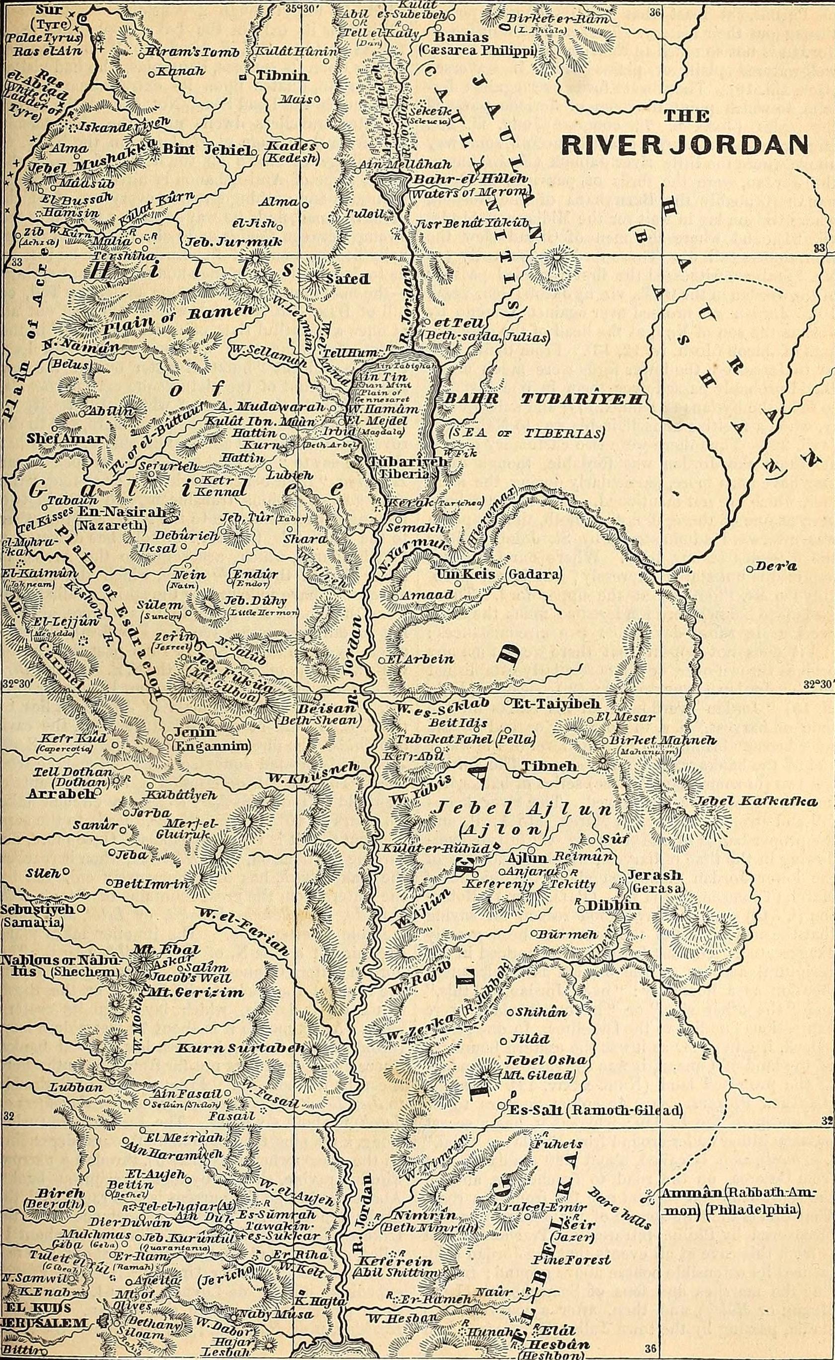
The Jordan River or River Jordan (, ''Nahr al-ʾUrdunn''; , ''Nəhar hayYardēn''), also known as ''Nahr Al-Sharieat'' (), is a endorheic river in the Levant that flows roughly north to south through the Sea of Galilee and drains to the Dead Sea. The river passes by or through Jordan, Syria, Israel, and the Palestinian territories. Jordan and the Israeli-occupied Golan Heights border the river to the east, while Israel and the Israeli-occupied West Bank lie to its west. Both Jordan and the West Bank derive their names in relation to the river. The river holds major significance in Judaism and Christianity. According to the Bible, the Israelites crossed it into the Promised Land and Jesus of Nazareth was baptized by John the Baptist in it. Etymology Several hypotheses for the origin of most of the river's names in modern languages (e.g., Jordan, Yarden, Urdunn), one is that it comes from Semitic 'Yard, on' 'flow down' <√ירד reflecting the river's declivity, possibly a ... [...More Info...] [...Related Items...] OR: [Wikipedia] [Google] [Baidu] |
Dead Sea
The Dead Sea (; or ; ), also known by #Names, other names, is a landlocked salt lake bordered by Jordan to the east, the Israeli-occupied West Bank to the west and Israel to the southwest. It lies in the endorheic basin of the Jordan Rift Valley, and its main tributary is the Jordan River. As of 2025, the lake's surface is below sea level, making its shores the Lowest elevations, lowest land-based elevation on Earth. It is deep, the deepest hypersaline lake in the world. With a salinity of 342 g/kg, or 34.2% (in 2011), it is one of the List of bodies of water by salinity, world's saltiest bodies of water, 9.6 times as Seawater#Salinity, salty as the ocean—and has a density of 1.24 kg/litre, which makes swimming similar to Buoyancy, floating. This salinity makes for a harsh environment in which plants and animals cannot flourish, hence its name. The Dead Sea's main, northern basin is long and wide at its widest point. The Dead Sea has attracted visitors from around th ... [...More Info...] [...Related Items...] OR: [Wikipedia] [Google] [Baidu] |
Nahal Hevron
The Nahal Hevron (נחל חברון; Hebron Stream), known in Arabic as the Wadi al-Khalil upstream and the Wadi al-Samen downstream, is a stream that flows along the border between Judea and the Negev. The source of the Nahal Hevron is in the city of Hebron, and its mouth is its confluence with Nahal Be'er Sheva near the settlement of Omer, Israel, Omer. It is a tributary of the Nahal Be'er Sheva and part of the Besor Stream drainage basin. The stream passes near Dahariya, Beersheba, and the northern Negev before it drains into the Nahal Be'er Sheva. In the territory of the State of Israel, the stream flows through the jurisdictional areas of Meitar, the former Abu Basma Regional Council, Abu Basma, Omer, and Tel Sheva, under the responsibility of the Ministry of Interior (Israel), Ministry of the Interior. Pollution Stream flowing wastewater from cities and industries, and wastewater from sawmills and quarries originating from Palestinian cities, residential areas, and quarri ... [...More Info...] [...Related Items...] OR: [Wikipedia] [Google] [Baidu] |
Nahal Be'er Sheva
The Nahal Be'er Sheva (נַחַל בְּאֵר שֶׁבַע; Beersheba Stream) is a stream in southern Israel which originates just west of Tel Arad, southeast of the Yatir Forest, and is a tributary of the Besor Stream. Its tributaries are the Nahal Yatir, the Nahal Hevron and the Nahal Sakher. It is named for the city of Beersheba, the largest city on its banks. A major archeological site on its banks is Tel Be'er Sheva. It contains many archeological finds, including a Bedouin livestock market at the Well of Abraham, which the Bedouin called the '' Suq al-Waqef'', a winepress and Byzantine-era tombs. It converges with the Besor Stream at a location known as the ''Mifgash'' (מפגש; Meeting place),A.N. Goring-Morris, P. Goldberg, Late Quaternary dune incursions in the southern levant: Archaeology, chronology and palaeoenvironments, Quaternary International, Volume 5, 1990, ISSN 1040-6182 [...More Info...] [...Related Items...] OR: [Wikipedia] [Google] [Baidu] |
Nahal Gerar
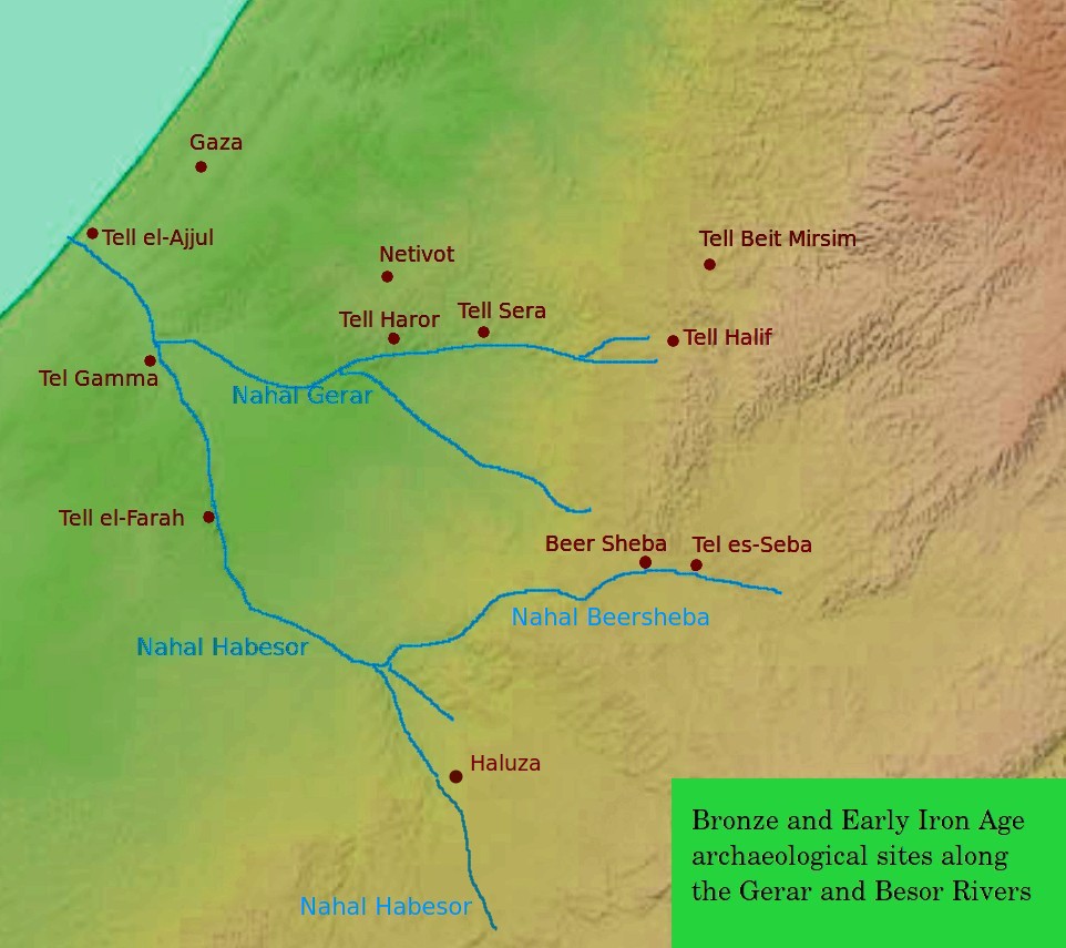
Nahal Gerar, also ''Nachal Grar'' () is a wadi in Israel, in the Negev desert. Its Arabic name is Wadi esh-Sheri'a (also Wady el Sharia and other variations). Along this wadi, there are several important ancient Bronze Age archaeological sites. During the Early Iron Age this was an area of Philistines, Philistine settlement. Geography Nahal Gerar begins on the border between the northern Negev and the southwest foothills of Judaean Mountains, near the village of Lahav (ancient site of Tel Halif). Then the wadi flows west near the city of Lehavim, and along the southern edge of a large Bedouin town of Rahat. Then it flows west along the northwestern edge of the Negev towards the town of Netivot, an agricultural area. Near the village of Re'im, it flows into Nahal Besor, of which it is the main affluent. Nature reserve The lower river area is now part of the Eshkol National Park, a nature reserve used by tourists. Forest have been replanted there, and hiking trails developed. T ... [...More Info...] [...Related Items...] OR: [Wikipedia] [Google] [Baidu] |


