|
Leslie Street Spit
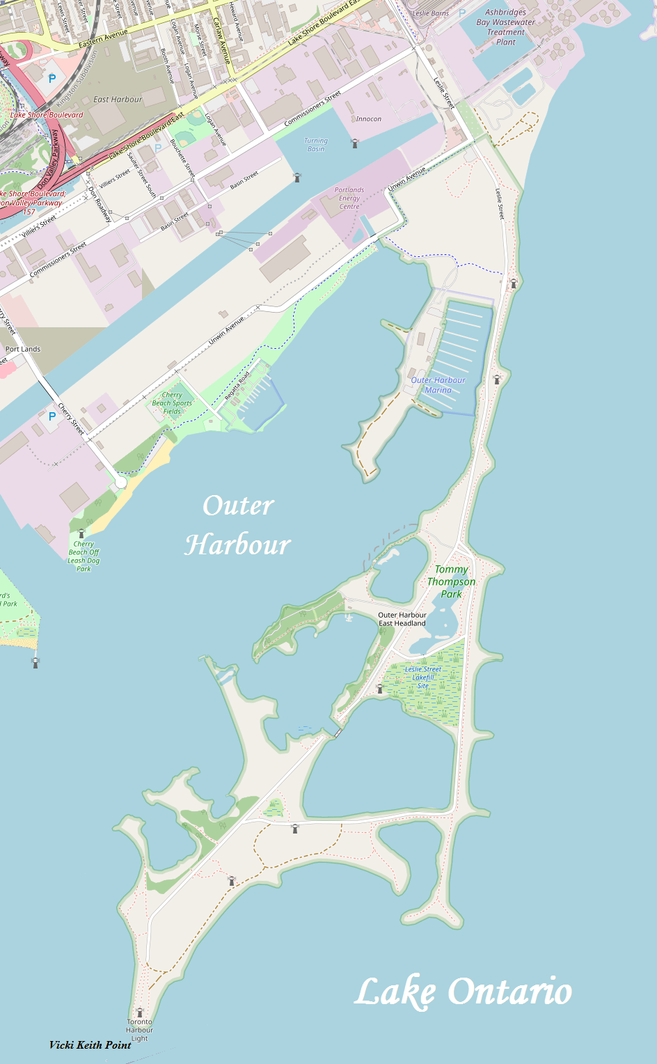
The Leslie Street Spit, or officially the Outer Harbour East Headland, is a human-made headland in Toronto, Ontario, Canada, extending from the city's east end in a roughly southwesterly direction into Lake Ontario. It is about long. The Spit is the result of five decades of lakefilling by the Toronto Port Authority. It was conceived as an extension of Toronto Harbour, and has evolved into a largely passive recreation area. Naturalization had not been planned but the process is now actively managed by the Toronto and Region Conservation Authority. A large portion of it is classified as an Environmentally Sensitive Area (ESA) and it is recognized as an Important Bird Area. Its common name is technically incorrect, since it is not truly a spit, but Torontonians almost never use the official name. The road running along the peninsula is a southern extension of Leslie Street, hence the popular nickname. The Canadian musical group Leslie Spit Treeo, prominent in the 1990s, too ... [...More Info...] [...Related Items...] OR: [Wikipedia] [Google] [Baidu] |
Boating
Boating is the leisurely activity of travelling by boat, or the recreational use of a boat whether powerboats, sailboats, or man-powered vessels (such as rowing and paddle boats), focused on the travel itself, as well as sports activities, such as fishing or waterskiing. It is a popular activity, and there are millions of boaters worldwide. Types of boats Boats (boat types) can be categorized into 3 different types of board categories: unpowered, motor boats, and sailboats. Recreational boats (sometimes called pleasure craft, especially for less sporting activities) fall into several broad categories, and additional subcategories. Broad categories include dinghies (generally under 16 feet (5 m) powered by sail, small engines, or muscle power) usually made from hardwood or inflatable rubber. paddle sports boats (kayaks, rowing shells, canoes), runabouts (15–25 ft. (5–8 m) powerboats with either outboard, sterndrive, or inboard engines), daysailers (14–25 Ft. (4–8 m) sai ... [...More Info...] [...Related Items...] OR: [Wikipedia] [Google] [Baidu] |
Car-free Area
Pedestrian zones (also known as auto-free zones and car-free zones, as pedestrian precincts in British English, and as pedestrian malls in the United States and Australia) are areas of a city or town restricted to use by people on foot or human-powered transport such as bicycles, with non-emergency motor traffic not allowed. Converting a street or an area to pedestrian-only use is called ''pedestrianisation''. Pedestrianisation usually aims to provide better accessibility and mobility for pedestrians, to enhance the amount of shopping and other business activities in the area or to improve the attractiveness of the local environment in terms of aesthetics, air pollution, noise and crashes involving motor vehicle with pedestrians. In some cases, motor traffic in surrounding areas increases, as it is displaced rather than replaced. Nonetheless, pedestrianisation schemes are often associated with significant falls in local air and noise pollution and in accidents, and frequent ... [...More Info...] [...Related Items...] OR: [Wikipedia] [Google] [Baidu] |
Ashbridge's Bay Beach
Ashbridges Bay is a bay and park in Toronto, Ontario, Canada. It is located along Lake Shore Boulevard next to Woodbine Beach in the Beaches. The Martin Goodman Trail and boardwalk run through the park along the bay. The boardwalk runs from Ashbridges Bay in the west to the R. C. Harris Water Treatment Plant in the east along Lake Ontario. It was once part of the marsh that lay east of Toronto Islands and Toronto Harbour. History Namesake The bay is named for Sarah Ashbridge, a British loyalist from Philadelphia whose family once lived nearby on a farm. It was once a five square kilometre marsh on the Don River delta and one of the largest wetlands in Eastern Canada. A breakwall formed on the western end with an outlet into Toronto Bay. Fisherman’s Island and reclamation Unwin Avenue follows the former sandbar or chain of islands once called Fisherman’s Island that once sheltered the bay from the western end of the current Inner Portlands to beyond Leslie Street to near ... [...More Info...] [...Related Items...] OR: [Wikipedia] [Google] [Baidu] |
Marsh
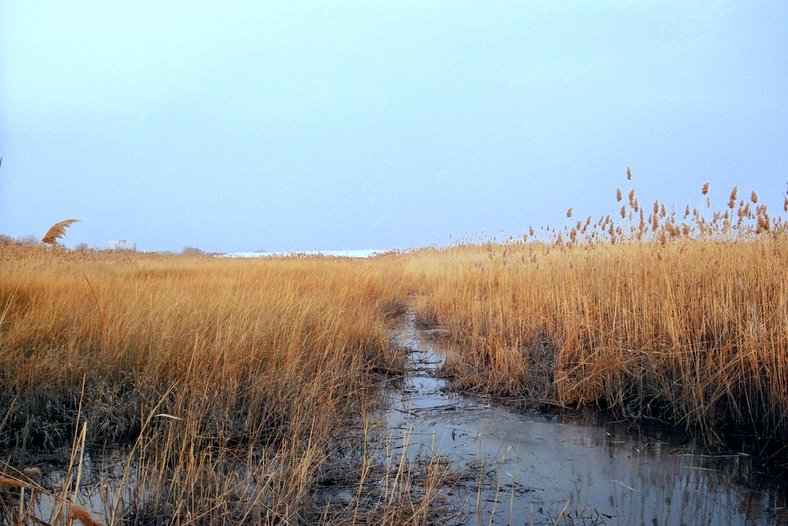
In ecology, a marsh is a wetland that is dominated by herbaceous plants rather than by woody plants.Keddy, P.A. 2010. Wetland Ecology: Principles and Conservation (2nd edition). Cambridge University Press, Cambridge, UK. 497 p More in general, the word can be used for any low-lying and seasonally waterlogged terrain. In Europe and in agricultural literature low-lying meadows that require draining and embanked polderlands are also referred to as marshes or marshland. Marshes can often be found at the edges of lakes and streams, where they form a transition between the aquatic and terrestrial ecosystems. They are often dominated by grasses, rushes or reeds. If woody plants are present they tend to be low-growing shrubs, and the marsh is sometimes called a carr. This form of vegetation is what differentiates marshes from other types of wetland such as swamps, which are dominated by trees, and mires, which are wetlands that have accumulated deposits of acidic peat. Marshes ... [...More Info...] [...Related Items...] OR: [Wikipedia] [Google] [Baidu] |
Dredging
Dredging is the excavation of material from a water environment. Possible reasons for dredging include improving existing water features; reshaping land and water features to alter drainage, navigability, and commercial use; constructing dams, dikes, and other controls for streams and shorelines; and recovering valuable mineral deposits or marine life having commercial value. In all but a few situations the excavation is undertaken by a specialist floating plant, known as a dredger. Usually the main objectives of dredging is to recover material of value, or to create a greater depth of water. Dredging systems can either be shore-based, brought to a location based on barges, or built into purpose-built vessels. Dredging can have environmental impacts: it can disturb marine sediments, creating dredge plumes which can lead to both short- and long-term water pollution, damage or destroy seabed ecosystems, and release legacy human-sourced toxins captured in the sediment. ... [...More Info...] [...Related Items...] OR: [Wikipedia] [Google] [Baidu] |
Embayment
A bay is a recessed, coastal body of water that directly connects to a larger main body of water, such as an ocean, a lake, or another bay. A large bay is usually called a ''gulf'', ''sea'', ''sound'', or ''bight''. A ''cove'' is a small, circular bay with a narrow entrance. A ''fjord'' is an elongated bay formed by glacial action. The term ''embayment'' is also used for , such as extinct bays or freshwater environments. A bay can be the estuary of a river, such as the Chesapeake Bay, an estuary of the Susquehanna River. Bays may also be nested within each other; for example, James Bay is an arm of Hudson Bay in northeastern Canada. Some large bays, such as the Bay of Bengal and Hudson Bay, have varied marine geology. The land surrounding a bay often reduces the strength of winds and blocks waves. Bays may have as wide a variety of shoreline characteristics as other shorelines. In some cases, bays have beaches, which "are usually characterized by a steep upper foreshore wit ... [...More Info...] [...Related Items...] OR: [Wikipedia] [Google] [Baidu] |
Ontario Place
Ontario Place was an entertainment venue, event venue, and park in Toronto, Ontario, Canada. The venue is located on three artificial landscaped islands just off-shore in Lake Ontario, south of Exhibition Place, and southwest of Downtown Toronto. It opened on May 22, 1971, and operated as a theme park centred around Ontario themes and family attractions until 2012 when the Government of Ontario announced that it would close for redevelopment. It has since reopened as a park without an admission fee but without several of the old attractions. The Government of Ontario has made controversial plan to place the 145 acres on a 95-year lease with the Swiss mega-spa builder Therme Group without public consultation or environmental assessments. Since the closure as a theme park, several of the venue's facilities have remained open, once reopened, and one section was redeveloped. The Budweiser Stage operates during the summer season. The Cinesphere, the original IMAX theatre, reopened ... [...More Info...] [...Related Items...] OR: [Wikipedia] [Google] [Baidu] |
PortsToronto
The Toronto Port Authority (TPA), doing business as PortsToronto (PT), is a port authority that is responsible for the management of the Port of Toronto, including the International Marine Passenger Terminal, and Billy Bishop Toronto City Airport. It was established under the '' Canada Marine Act'' as a government business enterprise that is self-funded, with directors appointed by three levels of government – the Government of Canada (through the Minister of Transport), the Government of Ontario and the City of Toronto. The TPA rebranded itself as PortsToronto in 2015. The organization is the successor to the Toronto Harbour Commission (THC) that had managed Toronto Harbour since 1911, paid for through government transfers, harbour and airport fees. As part of a Canada-wide plan of the Government of Canada to turn government commissions into self-sufficient agencies, the TPA was set up in 1999 to take over the port and airport functions of the THC. This was done against the ... [...More Info...] [...Related Items...] OR: [Wikipedia] [Google] [Baidu] |
Keating Channel
The Keating Channel is a long waterway in Toronto, Ontario, Canada. It connects the Don River to inner Toronto Harbour (Toronto Bay) on Lake Ontario. The channel is named after Edward Henry Keating (1844-1912), a city engineer (1892-1898) who proposed the creation of the channel in 1893. The channel was built to connect Ashbridge's Bay to the harbour; later, the Don was diverted into the channel, and its river mouth infilled in the early 1910s. History Prior to the 19th century, the Don River naturally entered Toronto Harbour in two mouths, one roughly near where Keating Channel now flows out and one further south. In the late 19th century, a public works program was started to straighten the lower part of the Don River south of the Winchester Street Bridge. The project was called the "Don Improvement Project". The goal of the project was to alleviate floods on the lower Don that were periodically washing out bridges. It was also done to create additional wharf space for the ... [...More Info...] [...Related Items...] OR: [Wikipedia] [Google] [Baidu] |


