|
Leeswood And Pontblyddyn
Leeswood and Pontblyddyn is a community in Flintshire, Wales in the United Kingdom, including the villages of Leeswood Leeswood ( cy, Coed-llai) is a village, community and electoral ward in Flintshire, Wales, about four miles from the historic market town of Mold. At the 2001 Census, the population was 2,143, reducing slightly to 2,135 at the 2011 Census. It ... and Pontblyddyn. The council was known as Leeswood Community Council before 26 January 2016. It is made of 11 elected councillors, 9 representing the Leeswood ward and 2 representing Pontblyddyn. The community covers the same area as the Leeswood electoral ward of Flintshire County Council, which elects one councillor. References External links Leeswood Community Online Communities in Flintshire {{Flintshire-geo-stub ... [...More Info...] [...Related Items...] OR: [Wikipedia] [Google] [Baidu] |
Flintshire
, settlement_type = County , image_skyline = , image_alt = , image_caption = , image_flag = , image_shield = Arms of Flintshire County Council.svg , shield_size = 100px , shield_alt = , shield_link = , image_blank_emblem = , blank_emblem_alt = , image_map = File: Flintshire UK location map.svg , map_alt = , map_caption = Flintshire shown within Wales , coordinates = , subdivision_type = Sovereign state , subdivision_name = , subdivision_type1 = Constituent country , subdivision_type2 = Preserved county , subdivision_name1 = , subdivision_name2 = Clwyd , established_title ... [...More Info...] [...Related Items...] OR: [Wikipedia] [Google] [Baidu] |
Clwyd
Clwyd () is a preserved county of Wales, situated in the north-east corner of the country; it is named after the River Clwyd, which runs through the area. To the north lies the Irish Sea, with the English ceremonial counties of Cheshire to the east and Shropshire to the south-east. Powys and Gwynedd lie to the south and west respectively. Clwyd also shares a maritime boundary with Merseyside along the River Dee. Between 1974 and 1996, a slightly different area had a county council, with local government functions shared with six district councils. In 1996, Clwyd was abolished, and the new principal areas of Conwy County Borough, Denbighshire, Flintshire and Wrexham County Borough were created; under this reorganisation, "Clwyd" became a preserved county, with the name being retained for certain ceremonial functions. This area of north-eastern Wales has been settled since prehistoric times; the Romans built a fort beside a ford on the River Conwy, and the Normans and Wel ... [...More Info...] [...Related Items...] OR: [Wikipedia] [Google] [Baidu] |
Mold, Flintshire
Mold ( cy, Yr Wyddgrug) is a town and community in Flintshire, Wales, on the River Alyn. It is the county town and administrative seat of Flintshire County Council, as it was of Clwyd from 1974 to 1996. According to the 2011 UK Census, it had a population of 10,058. A 2019 estimate puts it at 10,123. Origin of the name The original Welsh-language place name, ''Yr Wyddgrug'' was recorded as ''Gythe Gruc'' in a document of 1280–1281, and means "The Mound of the Tomb/Sepulchre". The name "Mold" originates from the Norman-French ''mont-hault'' ("high hill"). The name was originally applied to the site of Mold Castle in connection with its builder Robert de Montalt, an Anglo-Norman lord. It is recorded as ''Mohald'' in a document of 1254. History A mile west of the town is Maes Garmon, ("The Field of Germanus"), the traditional site of the "Alleluia Victory" by a force of Romano-Britons led by Germanus of Auxerre against the invading Picts and Scots, which occurred shortly a ... [...More Info...] [...Related Items...] OR: [Wikipedia] [Google] [Baidu] |
Leeswood
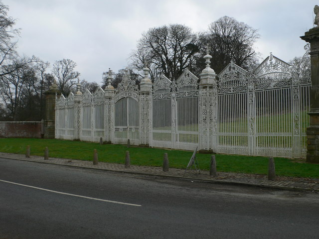
Leeswood ( cy, Coed-llai) is a village, community and electoral ward in Flintshire, Wales, about four miles from the historic market town of Mold. At the 2001 Census, the population was 2,143, reducing slightly to 2,135 at the 2011 Census. It was the centre of attention during the Mold Riot of 1869, where the owners of the mine refused to allow the speaking of the Welsh language in the mines. Around a quarter of Leeswood's resident population has some knowledge of the Welsh language, exceeding the county's average of 21.4%. In all categories of linguistic competency, the ward performs around the Flintshire average, although the proportion of those able only to understand spoken Welsh is higher than the county and national average. The famous White Gates of Leeswood Hall were attributed to the Davies brothers of Wrexham. The family of smiths were known in the 18th Century for their high-quality work using wrought-iron. The Wynne baronets were later to live in Leeswood Hall ... [...More Info...] [...Related Items...] OR: [Wikipedia] [Google] [Baidu] |
Pontblyddyn
Pontblyddyn is a small village outside Leeswood, in Flintshire, Wales and is situated around 8 miles from Wrexham. Plas Teg, one of the most important Jacobean era The Jacobean era was the period in English and Scottish history that coincides with the reign of James VI of Scotland who also inherited the crown of England in 1603 as James I. The Jacobean era succeeds the Elizabethan era and precedes the Ca ... houses in Wales, is located near the village. References Villages in Flintshire {{Flintshire-geo-stub ... [...More Info...] [...Related Items...] OR: [Wikipedia] [Google] [Baidu] |
Delyn (UK Parliament Constituency)
Delyn is a constituency represented in the House of Commons of the UK Parliament since 2019 by Rob Roberts, who was elected as a Conservative, but currently sits as an Independent following sexual harassment allegations. The Delyn Senedd constituency was created with the same boundaries in 1999 (as an Assembly constituency). Constituency profile The seat comprises the mostly industrial Deeside communities of Mostyn, Flint, Mold, Northop and Holywell. Residents are slightly less affluent than the UK average. Boundaries 1983–1997: The Borough of Delyn, and the Borough of Rhuddlan wards of Meliden, Prestatyn Central, Prestatyn East, Prestatyn North, and Prestatyn South West. 1997–2010: The Borough of Delyn. 2010–present: The Flintshire electoral divisions of Argoed, Bagillt East, Bagillt West, Brynford, Caerwys, Cilcain, Ffynnongroyw, Flint Castle, Flint Coleshill, Flint Oakenholt, Flint Trelawney, Greenfield, Gronant, Gwernaffield, Gwernymynydd, Halkyn, Holy ... [...More Info...] [...Related Items...] OR: [Wikipedia] [Google] [Baidu] |
Delyn (Senedd Constituency)
Delyn is a constituency of the Senedd. It elects one Member of the Senedd by the first past the post method of election. Also, however, it is one of nine constituencies in the North Wales electoral region, which elects four additional members, in addition to nine constituency members, to produce a degree of proportional representation for the region as a whole. Boundaries The constituency was created for the first election to the Assembly, in 1999, with the name and boundaries of the Delyn Westminster constituency. It is entirely within the preserved county of Clwyd Clwyd () is a preserved county of Wales, situated in the north-east corner of the country; it is named after the River Clwyd, which runs through the area. To the north lies the Irish Sea, with the English ceremonial counties of Cheshire to th .... As created in 1999, the North Wales region included the constituencies of Alyn and Deeside, Caernarfon, Clwyd West, Clwyd South, Conwy, Delyn, Val ... [...More Info...] [...Related Items...] OR: [Wikipedia] [Google] [Baidu] |
Community (Wales)
A community ( cy, cymuned) is a division of land in Wales that forms the lowest tier of local government in Wales. Welsh communities are analogous to civil parishes in England. There are 878 communities in Wales. History Until 1974 Wales was divided into civil parishes. These were abolished by section 20 (6) of the Local Government Act 1972, and replaced by communities by section 27 of the same Act. The principal areas of Wales are divided entirely into communities. Unlike in England, where unparished areas exist, no part of Wales is outside a community, even in urban areas. Most, but not all, communities are administered by community councils, which are equivalent to English parish councils in terms of their powers and the way they operate. Welsh community councils may call themselves town councils unilaterally and may have city status granted by the Crown. In Wales, all town councils are community councils. There are now three communities with city status: Bangor, St ... [...More Info...] [...Related Items...] OR: [Wikipedia] [Google] [Baidu] |
Ward (Wales)
The wards and electoral divisions in the United Kingdom are electoral districts at sub-national level, represented by one or more councillors. The ward is the primary unit of English electoral geography for civil parishes and borough and district councils, the electoral ward is the unit used by Welsh principal councils, while the electoral division is the unit used by English county councils and some unitary authorities. Each ward/division has an average electorate of about 5,500 people, but ward population counts can vary substantially. As of 2021 there are 8,694 electoral wards/divisions in the UK. England The London boroughs, metropolitan boroughs and non-metropolitan districts (including most unitary authorities) are divided into wards for local elections. However, county council elections (as well as those for several unitary councils which were formerly county councils, such as the Isle of Wight and Shropshire Councils) instead use the term ''electoral division''. In shi ... [...More Info...] [...Related Items...] OR: [Wikipedia] [Google] [Baidu] |
Electoral Ward (Wales)
The wards and electoral divisions in the United Kingdom are electoral districts at sub-national level, represented by one or more councillors. The ward is the primary unit of English electoral geography for civil parishes and borough and district councils, the electoral ward is the unit used by Welsh principal councils, while the electoral division is the unit used by English county councils and some unitary authorities. Each ward/division has an average electorate of about 5,500 people, but ward population counts can vary substantially. As of 2021 there are 8,694 electoral wards/divisions in the UK. England The London boroughs, metropolitan boroughs and non-metropolitan districts (including most unitary authorities) are divided into wards for local elections. However, county council elections (as well as those for several unitary councils which were formerly county councils, such as the Isle of Wight and Shropshire Councils) instead use the term ''electoral division''. In s ... [...More Info...] [...Related Items...] OR: [Wikipedia] [Google] [Baidu] |
Flintshire County Council
Flintshire County Council is the unitary local authority for the county of Flintshire, one of the principal areas of Wales. It is based at County Hall in Mold. Elections take place every five years. The last election was on 5 May 2022. History Flintshire County Council was first created in 1889 under the Local Government Act 1888, which established elected county councils to take over the administrative functions of the quarter sessions. That county council and the administrative county of Flintshire were abolished in 1974, when the area merged with neighbouring Denbighshire to become the new county of Clwyd. Flintshire was unusual in retaining exclaves right up until the 1974 reforms. The contiguous part of the county was split to become three of the six districts of Clwyd: Alyn and Deeside, Delyn, and Rhuddlan. The county's exclaves of Maelor Rural District and the parish of Marford and Hoseley both went to the Wrexham Maelor district. Under the Local Government (Wales ... [...More Info...] [...Related Items...] OR: [Wikipedia] [Google] [Baidu] |

