|
Kuroshio Current
The , also known as the Black Current or is a north-flowing, warm ocean current on the west side of the North Pacific Ocean basin. It was named for the deep blue appearance of its waters. Similar to the Gulf Stream in the North Atlantic, the Kuroshio is a powerful western boundary current that transports warm equatorial water poleward and forms the western limb of the North Pacific Gyre, North Pacific Subtropical Gyre. Off the East Coast of Japan, it merges with the Oyashio Current to form the North Pacific Current. The Kuroshio Current has significant effects on both physical and biological processes of the North Pacific Ocean, including nutrient and sediment transport, major pacific storm tracks and regional climate, and Pacific mode water formation.Terazaki, Makoto (1989) "Recent Large-Scale Changes in the Biomass of the Kuroshio Current Ecosystem" in Kenneth Sherman and Lewis M. Alexander (eds.), Biomass Yields and Geography of Large Marine Ecosystems (Boulder: Westview) AAA ... [...More Info...] [...Related Items...] OR: [Wikipedia] [Google] [Baidu] |
Ocean Gyre
In oceanography, a gyre () is any large system of ocean surface currents moving in a circular fashion driven by wind movements. Gyres are caused by the Coriolis effect; planetary vorticity, horizontal friction and vertical friction determine the circulatory patterns from the '' wind stress curl'' (torque). ''Gyre'' can refer to any type of vortex in an atmosphere or a sea, even one that is human-created, but it is most commonly used in terrestrial oceanography to refer to the major ocean systems. Gyre formation The largest ocean gyres are wind-driven, meaning that their locations and dynamics are controlled by the prevailing global wind patterns: easterlies at the tropics and westerlies at the midlatitudes. These wind patterns result in a wind stress curl that drives Ekman pumping in the subtropics (resulting in downwelling) and Ekman suction in subpolar regions (resulting in upwelling). Ekman pumping results in an increased sea surface height at the center of the gyre ... [...More Info...] [...Related Items...] OR: [Wikipedia] [Google] [Baidu] |
Manila Galleon
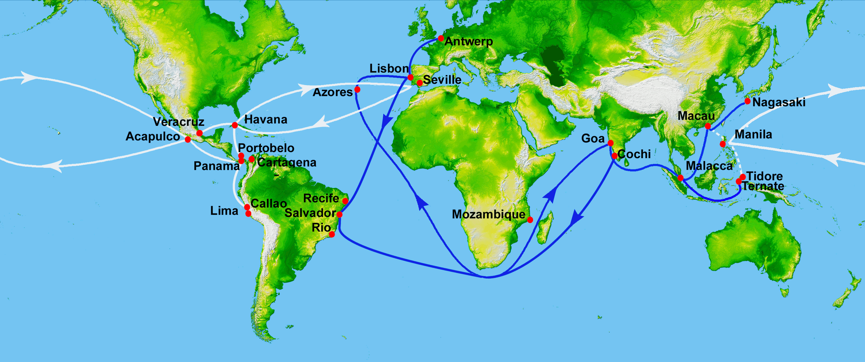
The Manila galleon (; ) refers to the Spain, Spanish trading Sailing ship, ships that linked the Philippines in the Spanish East Indies to Mexico (New Spain), across the Pacific Ocean. The ships made one or two round-trip voyages per year between the ports of Manila and Acapulco from the late 16th to early 19th century. The term "Manila galleon" can also refer to the trade route itself between Manila and Acapulco that was operational from 1565 to 1815. The Manila galleon trade route was inaugurated in 1565 after the Augustinians, Augustinian friar and navigator Andrés de Urdaneta pioneered the ''tornaviaje'' or return route from the Philippines to Mexico. Urdaneta and Alonso de Arellano made the first successful round trips that year, by taking advantage of the Kuroshio Current. The galleons set sail from Cavite, in Manila Bay, at the end of June or the first week of July, sailing through the northern Pacific and reaching Acapulco in March to April of the next calendar year. T ... [...More Info...] [...Related Items...] OR: [Wikipedia] [Google] [Baidu] |
California Current
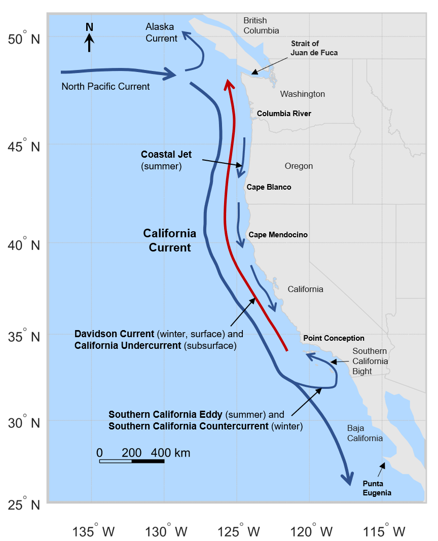
The California Current () is a cold water Pacific Ocean ocean current, current that moves southward along the western coast of North America, beginning off southern British Columbia and ending off southern Baja California Sur. It is considered an Eastern boundary current due to the influence of the North American coastline on its course. It is also one of six major coastal currents affiliated with strong upwelling zones, the others being the Humboldt Current, the Canary Current, the Benguela Current, the Oyashio Current, and the Somali Current. The California Current is part of the North Pacific Gyre, a large swirling current that occupies the northern basin of the Pacific. The related California Current Conservation Complex is a grouping of federally-designated marine protected areas that have been on the UNESCO list of tentative World Heritage Site, World Heritage Sites since 2017, which includes the following areas found throughout the current: the Point Reyes National Seashore ... [...More Info...] [...Related Items...] OR: [Wikipedia] [Google] [Baidu] |
Polar Region
The polar regions, also called the frigid zones or polar zones, of Earth are Earth's polar ice caps, the regions of the planet that surround its geographical poles (the North and South Poles), lying within the polar circles. These high latitudes are dominated by floating sea ice covering much of the Arctic Ocean in the north, and by the Antarctic ice sheet on the continent of Antarctica and the Southern Ocean in the south. Definitions The Arctic has various definitions, including the region north of the Arctic Circle (currently Epoch 2010 at 66°33'44" N), or just the region north of 60° north latitude, or the region from the North Pole south to the timberline. The Antarctic is usually defined simply as south of 60° south latitude, or the continent of Antarctica. The 1959 Antarctic Treaty uses the former definition. The two polar regions are distinguished from the other two climatic and biometric belts of Earth, a tropics belt near the equator, and two middle latitud ... [...More Info...] [...Related Items...] OR: [Wikipedia] [Google] [Baidu] |
Atlantic Ocean
The Atlantic Ocean is the second largest of the world's five borders of the oceans, oceanic divisions, with an area of about . It covers approximately 17% of Earth#Surface, Earth's surface and about 24% of its water surface area. During the Age of Discovery, it was known for separating the New World of the Americas (North America and South America) from the Old World of Afro-Eurasia (Africa, Asia, and Europe). Through its separation of Afro-Eurasia from the Americas, the Atlantic Ocean has played a central role in the development of human society, globalization, and the histories of many nations. While the Norse colonization of North America, Norse were the first known humans to cross the Atlantic, it was the expedition of Christopher Columbus in 1492 that proved to be the most consequential. Columbus's expedition ushered in an Age of Discovery, age of exploration and colonization of the Americas by European powers, most notably Portuguese Empire, Portugal, Spanish Empire, Sp ... [...More Info...] [...Related Items...] OR: [Wikipedia] [Google] [Baidu] |
Bōsō Peninsula
The is a peninsula that encompasses the entirety of Chiba Prefecture on Honshu, the largest island of Japan. It is part of the Greater Tokyo Area. It forms the eastern edge of Tokyo Bay, separating it from the Pacific Ocean. The peninsula covers approximately . Description The Bōsō Peninsula is defined by the Pacific Ocean to its east and south, Tokyo Bay to the west, and the Edo and Tone rivers to the north. The Bōsō Hill Range forms the backbone of the south of the peninsula, and much of the area is hilly. Mount Atago in Minamibōsō and Kamogawa is the highest point on the peninsula with an altitude of . From south to north the Bōsō Hill Range gives way to the Shimōsa Plateau, which covers much of the area of northern Chiba Prefecture, and ends in the lower areas around the Tone River. The northern and western parts of the Bōsō Peninsula are highly urbanized. The Shimōsa Plateau and the coastal lowlands and interior river valleys are chiefly used for rice cul ... [...More Info...] [...Related Items...] OR: [Wikipedia] [Google] [Baidu] |
Okinawa Trough
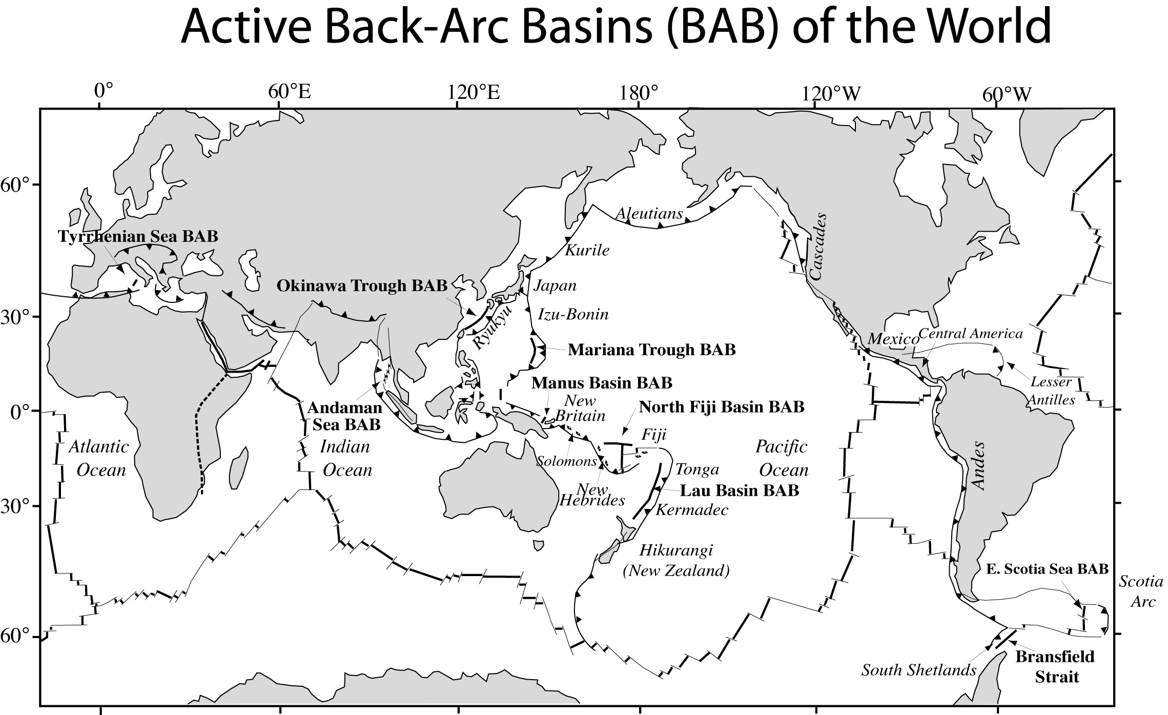
The (also called , literally "China-Ryukyu Border Trough") is a seabed feature of the East China Sea. It is an active, initial back-arc rifting basin which has formed behind the Ryukyu arc-trench system in the West Pacific. It developed where the Philippine Sea Plate is subducting under the Eurasia Plate. Description It is a back-arc basin formed by extension within the continental lithosphere behind the far deeper Ryukyu Trench-arc system. The thickness of the crust in the northern Okinawa Trough is 30 km, thinning to 10 km in the southern Okinawa Trough. It has a large section more than deep and a maximum depth of . The Okinawa Trough still in an early stage of evolving from arc type to back-arc activity, and features volcanoes such as the Yonaguni Knoll IV. Implications for the China–Japan maritime boundary Interpretations The existence of the Okinawa Trough complicates descriptive issues in the East China Sea.Ji, Guoxing. (1995) "Maritime Jurisdiction in t ... [...More Info...] [...Related Items...] OR: [Wikipedia] [Google] [Baidu] |
Ryukyu Islands
The , also known as the or the , are a chain of Japanese islands that stretch southwest from Kyushu to Geography of Taiwan, Taiwan: the Ryukyu Islands are divided into the Satsunan Islands (Ōsumi Islands, Ōsumi, Tokara Islands, Tokara and Amami Islands, Amami) and Okinawa Prefecture (Daitō Islands, Daitō, Miyako Islands, Miyako, Yaeyama Islands, Yaeyama, Senkaku Islands, Senkaku, Okinawa Islands, Okinawa, Sakishima Islands (further divided into the Miyako Islands, Miyako and Yaeyama Islands), and Yonaguni as the westernmost). The larger ones are mostly volcanic islands and the smaller mostly coral island, coral. The largest is Okinawa Island. The climate of the islands ranges from humid subtropical climate (Köppen climate classification ''Cfa'') in the north to tropical rainforest climate (Köppen climate classification ''Af'') in the south. Precipitation is very high and is affected by the rainy season and typhoons. Except the outlying Daitō Islands, the island chain ha ... [...More Info...] [...Related Items...] OR: [Wikipedia] [Google] [Baidu] |
Sea Of Japan
The Sea of Japan is the marginal sea between the Japanese archipelago, Sakhalin, the Korean Peninsula, and the mainland of the Russian Far East. The Japanese archipelago separates the sea from the Pacific Ocean. Like the Mediterranean Sea, it has almost no tides due to its nearly complete enclosure from the Pacific Ocean. This isolation also affects faunal diversity and salinity, both of which are lower than in the open ocean. The sea has no large islands, bays or capes. Its water balance is mostly determined by the inflow and outflow through the straits connecting it to the neighboring seas and the Pacific Ocean. Few rivers discharge into the sea and their total contribution to the water exchange is within 1%. The seawater has an elevated concentration of Oxygen saturation, dissolved oxygen that results in high biological productivity. Therefore, fishing is the dominant economic activity in the region. The intensity of shipments across the sea has been moderate owing to politi ... [...More Info...] [...Related Items...] OR: [Wikipedia] [Google] [Baidu] |
Mindanao Current
The Mindanao Current (MC) is a southward current in the western Pacific Ocean that transports mass and freshwater between ocean basins. It is a low-latitude western boundary current that follows the eastern coast of the Philippine island group and its namesake, Mindanao. The MC forms from the North Equatorial Current (NEC) that flows from east to west between 10-20°N. As it travels west, the NEC reaches its western limit: the coast of the Philippines. Once it encounters shallower waters near land, it “splits” into two branches: one moves northward and becomes the Kuroshio current and one moves southward and becomes the Mindanao Current. The process of splitting is called a bifurcation. The Mindanao Current flows towards the equator and is most intense near the surface, reaching maximum speeds of 1.3 ms^. It can be observed until depths of 1000 m near the Philippine coast and extends until 350 km offshore. The MC transports climatic signals and in doing so, influences the reg ... [...More Info...] [...Related Items...] OR: [Wikipedia] [Google] [Baidu] |
Luzon
Luzon ( , ) is the largest and most populous List of islands in the Philippines, island in the Philippines. Located in the northern portion of the List of islands of the Philippines, Philippine archipelago, it is the economic and political center of the nation, being home to the country's capital city, Manila, as well as Quezon City, the country's most populous city. With a population of 64 million , it contains 52.5% of the country's total population and is the List of islands by population, 4th most populous island in the world. It is the List of islands by area, 15th largest island in the world by land area. ''Luzon'' may also refer to one of the three primary Island groups of the Philippines, island groups in the country. In this usage, it includes the Luzon Mainland, the Batanes and Babuyan Islands, Babuyan groups of islands to the north, Polillo Islands to the east, and the outlying islands of Catanduanes, Marinduque and Mindoro, among others, to the south. The islands o ... [...More Info...] [...Related Items...] OR: [Wikipedia] [Google] [Baidu] |


