|
Kullu District
Kullu () is a List of districts in India, district in Himachal Pradesh, India. It borders Shimla district to the south, Mandi district, Mandi and Kangra district, Kangra districts to the west, Kinnaur district, Kinnaur to the east and the Lahaul and Spiti district, Lahaul and Spiti district to the north and east. The largest valley in this mountainous district is the Kullu Valley. The Kullu valley follows the course of the Beas River, and ranges from an elevation of 833m above sea level at Aut to 3330m above sea level at the Atal Tunnel South Portal, below the Rohtang Pass. The town of Kullu, located on the right side of the Beas River, serves as the administrative headquarters of the Kullu district. The Kullu district also incorporates several riverine tributary valleys of the Beas, including those of the Parvati River (Himachal Pradesh), Parvati, Sainj, and Tirthan rivers, and thus some regions somewhat distant from the Kullu valley. The economy of the district relies mainly on ... [...More Info...] [...Related Items...] OR: [Wikipedia] [Google] [Baidu] |
List Of Districts Of Himachal Pradesh
The northern India, Indian state of Himachal Pradesh is divided into 12 districts, the Revenue department of which is headed by a Deputy Commissioner (India), Deputy Commissioner or District Magistrate, an officer belonging to the Indian Administrative Service. The district magistrate or the deputy commissioner is assisted by a number of officers belonging to Himachal Administrative Service and other Himachal state services. A District Judge serves as the head of the Judiciary of the district. Courts subordinate to him include those of the Civil Judges, Senior Civil Judges, and Judicial Magistrates. A Superintendent of Police (India), Superintendent of Police, an officer belonging to the Indian Police Service is entrusted with the responsibility of maintaining law and order and related issues of the district. He is assisted by the officers of the Himachal Police Service and other Himachal Police officials. A Deputy Conservator of Forests, an officer belonging to the Indian Fo ... [...More Info...] [...Related Items...] OR: [Wikipedia] [Google] [Baidu] |
Lahaul And Spiti District
The Lahaul and Spiti district is a high-altitude district in Himachal Pradesh, north India. This entirely mountainous district consists of two geographically distinct as well as formerly separate political-administrative units, called Lahaul () and Spiti (; or ). Lahaul and Spiti is the largest district by area in Himachal Pradesh, and one of the least populous districts in the whole of India. Kyelang (also spelled as 'Keylong') in Lahaul is the headquarters of the whole district, while Spiti also has a subdivisional headquarters, at Kaza. Geography Physical Geologically located in the Himalayas and the Tibetan Plateau, Lahaul and Spiti district is connected to Manali through the Rohtang Pass. Lahaul has three valleys, the Chandra valley (locally known as Rangloi valley), the Bhaga valley (locally known as Ghar valley), and the Chandra-Bhaga valley (locally known as Pattan valley, and further on as Chenab valley). The confluence of the Chandra and the Bhaga rivers ... [...More Info...] [...Related Items...] OR: [Wikipedia] [Google] [Baidu] |
Punjab, India
Punjab () is a States and union territories of India, state in northwestern India. Forming part of the larger Punjab, Punjab region of the Indian subcontinent, the state is bordered by the States and union territories of India, Indian states of Himachal Pradesh to the north and northeast, Haryana to the south and southeast, and Rajasthan to the southwest; by the Indian union territory, union territories of Jammu and Kashmir (union territory), Jammu and Kashmir to the north and Chandigarh to the east. To the west, it shares an international border with the identically named Pakistani province of Punjab, Pakistan, Punjab, and as such is sometimes referred to as East Punjab or Indian Punjab for disambiguation purposes. The state covers an area of 50,362 square kilometres (19,445 square miles), which is 1.53% of India's total geographical area, making it List of states and union territories of India by area, the 19th-largest Indian state by area out of 28 Indian states (20th larges ... [...More Info...] [...Related Items...] OR: [Wikipedia] [Google] [Baidu] |
Independence Of India
The Indian independence movement was a series of historic events in South Asia with the ultimate aim of ending British Raj, British colonial rule. It lasted until 1947, when the Indian Independence Act 1947 was passed. The first nationalistic movement took root in the newly formed Indian National Congress with prominent moderate leaders seeking the right to appear for Indian Civil Service examinations in British India, as well as more economic rights for natives. The first half of the 20th century saw a more radical approach towards self-rule. The stages of the independence struggle in the 1920s were characterised by the leadership of Mahatma Gandhi and Congress's adoption of Gandhi's policy of non-violence and Salt March, civil disobedience. Some of the leading followers of Gandhi's ideology were Jawaharlal Nehru, Vallabhbhai Patel, Abdul Ghaffar Khan, Maulana Azad, and others. Intellectuals such as Rabindranath Tagore, Subramania Bharati, and Bankim Chandra Chattopadhyay spr ... [...More Info...] [...Related Items...] OR: [Wikipedia] [Google] [Baidu] |
Presidencies And Provinces Of British India
The provinces of India, earlier presidencies of British India and still earlier, presidency towns, were the administrative divisions of British governance in South Asia. Collectively, they have been called British India. In one form or another, they existed between 1612 and 1947, conventionally divided into three historical periods: *Between 1612 and 1757, the East India Company set up Factory (trading post), "factories" (trading posts) in several locations, mostly in coastal India, with the consent of the Mughal Empire, Mughal emperors, Maratha Empire or local rulers. Its rivals were the merchant trading companies of Portugal, Denmark, the Netherlands, and France. By the mid-18th century three ''Presidency towns'': Madras, Bombay and Calcutta, had grown in size. *During the period of Company rule in India, 1757–1858, the Company gradually acquired sovereignty over large parts of India, now called "Presidencies". However, it also increasingly came under British government ove ... [...More Info...] [...Related Items...] OR: [Wikipedia] [Google] [Baidu] |
Punjab Province (British India)
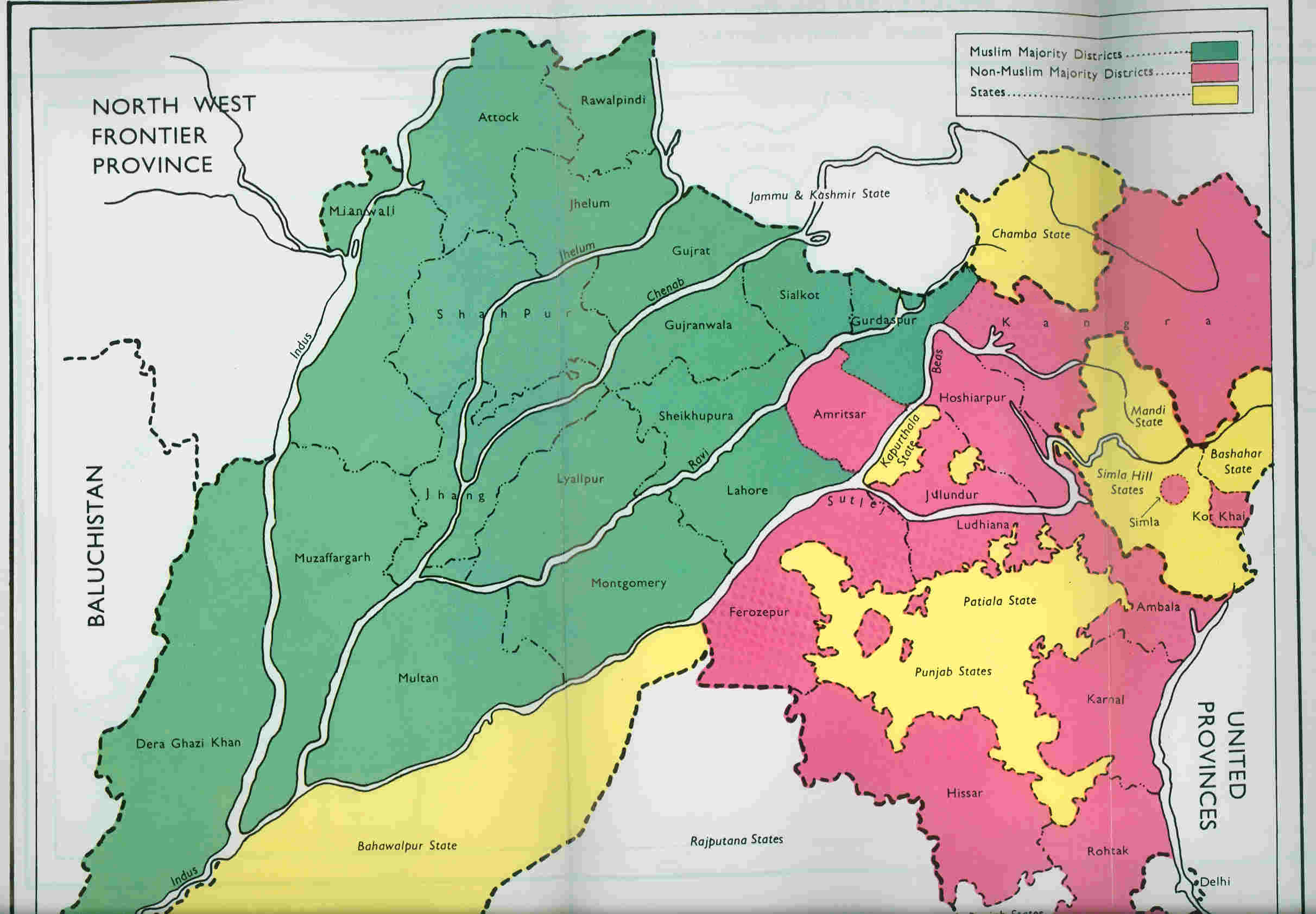
The Punjab Province, officially the Province of the Punjab, was a Presidencies and provinces of British India, province of British India, with its capital in Lahore and summer capitals in Murree and Simla. At its greatest extent, it stretched from the Khyber Pass to Delhi; and from the Babusar Pass and the borders of Tibet to the borders of Sind Division, Sind. Established in 1849 following #History, Punjab's annexation, the province was Partition of India#Punjab, partitioned in 1947 into West Punjab, West and East Punjab; and incorporated into Pakistan and India, respectively. Most of the Punjab, Punjab region was annexed by the East India Company on Second Anglo-Sikh War, 29 March 1849 following the company's victory at the Battle of Gujrat, battle of Gujrat in northern Punjab, a month prior. The Punjab was the last major region of the Indian subcontinent to fall to British imperialism. Immediately following its annexation, the Punjab was annexed into the Bengal Presidency a ... [...More Info...] [...Related Items...] OR: [Wikipedia] [Google] [Baidu] |
British Empire
The British Empire comprised the dominions, Crown colony, colonies, protectorates, League of Nations mandate, mandates, and other Dependent territory, territories ruled or administered by the United Kingdom and its predecessor states. It began with the English overseas possessions, overseas possessions and trading posts established by Kingdom of England, England in the late 16th and early 17th centuries, and colonisation attempts by Kingdom of Scotland, Scotland during the 17th century. At its height in the 19th and early 20th centuries, it became the List of largest empires, largest empire in history and, for a century, was the foremost global power. By 1913, the British Empire held sway over 412 million people, of the world population at the time, and by 1920, it covered , of the Earth's total land area. As a result, Westminster system, its constitutional, Common law, legal, English language, linguistic, and Culture of the United Kingdom, cultural legacy is widespread. ... [...More Info...] [...Related Items...] OR: [Wikipedia] [Google] [Baidu] |
Sikh Empire
The Sikh Empire was a regional power based in the Punjab, Punjab region of the Indian subcontinent. It existed from 1799, when Maharaja Ranjit Singh captured Lahore, to 1849, when it was defeated and conquered by the East India Company, British East India Company following the Second Anglo-Sikh War. At its peak in the mid-19th century the empire extended from Gilgit and Tibet under Qing rule, Tibet in the north to the Thar Desert, deserts of Sindh in the south and from the Khyber Pass in the west to the Sutlej in the east, and was divided into eight provinces. Religiously diverse, with an estimated population of 4.5 million in 1831 (making it the List of countries by population in 1800, 19th most populous state at the time), it was the last major region of the Indian subcontinent to be annexed by the British Raj, British Empire. In 1799, Ranjit Singh of Sukerchakia Misl captured Lahore from the Sikh triumvirate which had been ruling it Sikh period in Lahore#Sikh triumvirate ... [...More Info...] [...Related Items...] OR: [Wikipedia] [Google] [Baidu] |
Ranjit Singh
Ranjit Singh (13 November 1780 – 27 June 1839) was the founder and first maharaja of the Sikh Empire, in the northwest Indian subcontinent, ruling from 1801 until his death in 1839. Born to Maha Singh, the leader of the Sukerchakia Misl, Ranjit Singh survived smallpox in infancy but lost sight in his left eye. At the age of ten years old, he fought his first battle alongside his father. After his father died around Ranjit's early teenage years, he became leader of the Misl. Ranjit was the most prominent of the Sikh leaders who opposed Zaman Shah, the ruler of Durrani Empire, during his third invasion. After Zaman Shah's retreat in 1799, he captured Lahore from the Sikh triumvirate which had been ruling it since 1765. At the age of 21, he was formally crowned at Lahore. Before his rise, the Punjab had been fragmented into a number of warring Sikh (known as misls), Muslim and Hindu states. A large part of Punjab was under direct Durrani control. By 1813, Ranjit Sin ... [...More Info...] [...Related Items...] OR: [Wikipedia] [Google] [Baidu] |
Raja Jagat Singh
Raja Jagat Singh was a Rajput ruler of the Nurpur kingdom. History When the Nurpur kingdom was being heavily taxed in 1630 by the Mughals, its king Raja Jagat Singh instead of taxing sided with people, who were starving during the famine and paid taxes from his own pocket. A lack of rain for three years caused the Deccan famine of 1630–32. It affected the Gujarat, Malwa, and Deccan regions while the Mughals carried out a war campaign. While the entire province lay dead, Shah Jahan's war camp was “fair and spacious, plentifully stored with all provisions, being supplied with all things from all parts, far and near”. While people in the entire province were dying due to famine caused by his own army, Shah Jahan was collecting money to build the Taj Mahal, the construction of which began on 1632. Taxes in the Mughal Empire were among the highest in the world; according to the estimates of J.N.U scholar Shireen Moosvi, Mughals took 56.7% of total produce from peasants. Wh ... [...More Info...] [...Related Items...] OR: [Wikipedia] [Google] [Baidu] |
Naggar Castle
Naggar Castle is a medieval castle, located in Kullu, Himachal Pradesh, India India, officially the Republic of India, is a country in South Asia. It is the List of countries and dependencies by area, seventh-largest country by area; the List of countries by population (United Nations), most populous country since .... Built by Raja Sidh Singh of Kullu around 1460 A.D, it was taken over by the Himachal Pradesh Tourism Development Corporation (HPTDC), to run as a heritage hotel, in 1978. History It was the official seat of kings for centuries. According to a legend, Raja Sidh Singh used stones from the abandoned palace (Gardhak) of Rana Bhonsal to build the castle. Gallery See also * Naggar, an ancient town in Kullu district of Himachal Pradesh References {{coord, 32.112, 77.165, display=title Kullu Fortifications in India ... [...More Info...] [...Related Items...] OR: [Wikipedia] [Google] [Baidu] |
Rohtang Pass
Rohtang Pass (Rohtang , literally meaning "pile of corpses"Polgreen, Lydia. ''New York Times''. Accessed 31 July 2010.) is a high mountain pass (elevation ) on the eastern end of the Pir Panjal Range of the Himalayas around from Manali, Himachal Pradesh, Manali in the Indian state of Himachal Pradesh, the pass serves as a vital link between the verdant Kullu district, Kullu Valley and the arid, high-altitude regions of Lahaul and Spiti district, Lahaul and Spiti Valleys of Himachal Pradesh, India. Known for its dramatic topography and stunning panoramic views, Rohtang Pass attracts travelers, photographers, and nature enthusiasts from across the world. The journey to the pass itself is marked by a striking contrast—lush green hills gradually giving way to rugged, snow-clad peaks and barren alpine terrain. To make the scenic route accessible to visitors, the Himachal Pradesh Tourism Development Corporation (HPTDC) operates a daily sightseeing tour to Rohtang Pass from Mall ... [...More Info...] [...Related Items...] OR: [Wikipedia] [Google] [Baidu] |


