|
Jajinci
Jajinci ( sr-Cyrl, Јајинци, ) is an urban neighborhood located in the municipality of Voždovac, in Belgrade, Serbia. It was the site of the worst carnage in Serbia during World War II when German occupational forces executed nearly 80,000 people, many of them prisoners of the nearby Banjica concentration camp. Jewish women and children from German Sajmište concentration camp, killed in a special gas truck on their way to Belgrade were also buried here. Location Jajinci is located in the Lipnica creek valley. Once a small village far from downtown Belgrade, Jajinci today has grown into one continuous metropolitan area with the rest of the city. It borders the neighborhoods of Banjica on the north, Kumodraž on the east, and Selo Rakovica on the south. The eastern border of the neighborhood is marked by the Jelezovac creek, which also forms a border with the municipality of Rakovica. Characteristics Boža Radulović, merchant, brought the first car in Belgrade on 3 ... [...More Info...] [...Related Items...] OR: [Wikipedia] [Google] [Baidu] |
Banjica Concentration Camp
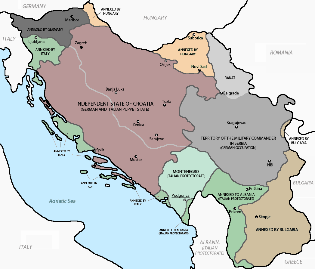
The Banjica concentration camp (, sr-Cyrl-Latn, Бањички логор, Banjički logor) was a Nazi German concentration camp in the Territory of the Military Commander in Serbia, the military administration of the Third Reich established after the Invasion and occupation of Yugoslavia during World War II. In response to escalating resistance, the German army instituted severe repressive measures – mass executions of civilian hostages and the establishment of concentration camps. Located in the Banjica neighborhood of Dedinjea suburb of Belgradeit was originally used by the Germans as a center for holding hostages. The camp was later used to hold anti-fascist Serbs, Jews, Roma, captured Partisans, Chetniks and other opponents of Nazi Germany. By 1942, most executions occurred at the firing ranges at Jajinci, Marinkova Bara and the Jewish cemetery. Banjica was operational from July 1941 to October 1944. It was jointly run by German occupiers under the command of Gesta ... [...More Info...] [...Related Items...] OR: [Wikipedia] [Google] [Baidu] |
Subdivisions Of Belgrade
Serbia's capital city of Belgrade is divided into 17 municipality, municipalities. Most of the Municipalities of Serbia, municipalities are situated on the southern side of the Danube and Sava rivers, in the Šumadija region. Three municipalities (Zemun, Novi Beograd, and Surčin) are on the northern bank of the Sava, in the Syrmia region, and the municipality of Palilula (Belgrade), Palilula, spanning the Danube, is in both the Šumadija and Banat regions. Municipalities Governmental structure A municipality is a part of the territory of the City of Belgrade, in which certain operations of local self-government laid down by the City Charter are run. Pursuant to the Constitution, legislation, present Charter and bylaws of the municipality, the citizens participate in conducting operations of the municipality through the councilors elected to the municipal assembly, civil initiative, local citizens’ meeting and referendum. The bodies of the municipality are: *Municipa ... [...More Info...] [...Related Items...] OR: [Wikipedia] [Google] [Baidu] |
Jelezovac
Jelezovac ( sr-Cyr, Јелезовац) is an urban neighborhood of Belgrade, the capital of Serbia. It is located in the municipality of Rakovica. Though official city documents refer to the area as part of the Sunčani Breg-Jelezovac settlement, the neighborhood which developed in the western part of the Jelezovac area is known as Miljakovac III. Jelezovac remains as the name for the brook and its, still partially non-urbanized valley. Location Jelezovac area occupies entire central-east part of the Rakovica municipality, adjoining the Voždovac municipality and its neighborhood of Jajinci (sub-neighborhoods Rasadnik and Mala Utrina). It is bordered by Kanarevo Brdo and southeast extension of Banjica II are on the north and Miljakovac II and Miljakovac Forest on the northwest. Central western section is urbanized as Miljakovac III while on the south it reaches the Kružni Put thoroughfare, and the neighborhoods of Resnik (to the west) and Selo Rakovica (to the east). ... [...More Info...] [...Related Items...] OR: [Wikipedia] [Google] [Baidu] |
Territory Of The Military Commander In Serbia
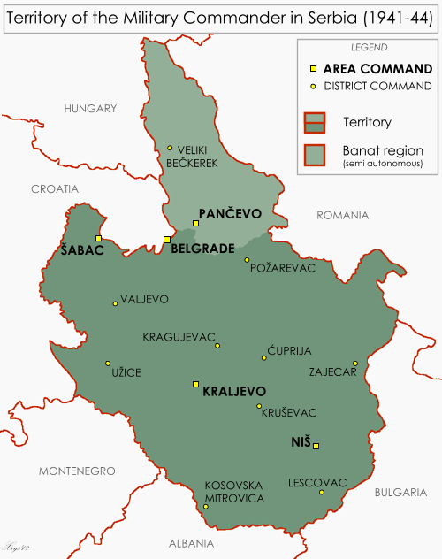
The Territory of the Military Commander in Serbia (; ) was the area of the Kingdom of Yugoslavia that was placed under a military government of occupation by the Wehrmacht following the invasion, occupation and dismantling of Yugoslavia in April 1941. The territory included only most of modern central Serbia, with the addition of the northern part of Kosovo (around Kosovska Mitrovica), and the Banat. This territory was the only area of partitioned Yugoslavia in which the German occupants established a military government. This was due to the key rail and the Danube transport routes that passed through it, and its valuable resources, particularly non-ferrous metals. On 22 April 1941, the territory was placed under the supreme authority of the German military commander in Serbia, with the day-to-day administration of the territory under the control of the chief of the military administration staff. The lines of command and control in the occupied territory were never unified, ... [...More Info...] [...Related Items...] OR: [Wikipedia] [Google] [Baidu] |
Kumodraž
Kumodraž ( sr-cyr, Кумодраж, ) is an urban neighborhood of Belgrade, Serbia. It is located in Belgrade's municipality of Voždovac. Location Kumodraž is located in the central-eastern part of the municipality, in the lower section of the Kumodraž field (''Kumodraško polje''), within the valley of ''Kumodraški potok creek''. Eastern and southern borders of the neighborhood are marked by a series of hills: Torlak, Golo Brdo, Stražarska Kosa, and the Kumodraž area is a source of many other creeks apart from the one that gave its name to the neighborhood: Rakovički potok (flows through the neighborhoods of Selo Rakovica and Rakovica), ''Lipica'' ( Jajinci), ''Zavojnička reka'' (a tributary to the Bolečica river), ''Bubanj potok'' (flows through Bubanj Potok, also a tributary to the Bolečica), ''Kamena voda'', etc. To the north, Kumodraž is bordered by the neighborhood of Voždovac, to the north-west by Veliki Mokri Lug and to the east by Jajinci. Population ... [...More Info...] [...Related Items...] OR: [Wikipedia] [Google] [Baidu] |
Banjica
Banjica (, ) is an urban neighborhood of Belgrade, the capital of Serbia. It's divided between Belgrade's municipalities of Savski Venac (western half) and Voždovac (eastern half). Location Banjica is located 5–6 kilometers south of the center of Belgrade ( Terazije), on the Banjica hill. On the southwest, the hill descends into the valley and neighborhood of Lisičji Potok and further continues into the hill and woods of Topčider while on the southwest and souuth it descends into the valley of the creek of ''Kaljavi potok'', bordering the neighborhoods of Kanarevo Brdo (south-west) and Jajinci (south). To the west, Banjica extends into the elite neighborhood of Dedinje while the eastern side is covered by the Banjica forest, a long narrow belt of deciduous woodland along the Boulevard of Liberation, which used to separate Banjica from the neighborhoods of Voždovac and Trošarina. Nowadays those neighborhoods are connected to Banjica. Geography There are two for ... [...More Info...] [...Related Items...] OR: [Wikipedia] [Google] [Baidu] |
Selo Rakovica
Selo Rakovica () is an urban neighborhood of Belgrade, the capital of Serbia. It is located in Belgrade's municipality of Voždovac and should not be confused with the neighborhood of Rakovica in the municipality of the same name. Location Selo Rakovica is located in the central part of the municipality, in the valley of the creeks of Rakovički potok and ''Milošev potok'', some 10 kilometers south-east of downtown Belgrade. Once a small village distant from downtown, Selo Rakovica today grew into one continuous built-up area with the rest of the city, bordering the neighborhoods of Jajinci on the north and Pinosava on the south. Characteristics At the time, Selo Rakovica got the official prefix ''selo'' (Serbian for "village") to make a distinction from the much larger, industrial suburb of Rakovica. However, in the 1970s, Selo Rakovica was also annexed to the Belgrade City proper (''uža teritorija grada'') but the style ''Selo'' remained in an unofficial use. It is comple ... [...More Info...] [...Related Items...] OR: [Wikipedia] [Google] [Baidu] |
Voždovac
Voždovac ( sr-Cyrl, Вождовац, ) is a Subdivisions of Belgrade, municipality of the city of Belgrade. According to the 2022 census results, the municipality has a population of 174,864 inhabitants. The municipality is located in the south-central part of the urban area of Belgrade and in the central section of the wider Belgrade City area. It stretches meridionally (north to south) for almost , spreading to the south more than any other municipality of Belgrade. Due to its shape, it borders more municipalities than any other: Vračar on the north, Zvezdara on the north-east, Grocka on the east, Sopot, Serbia, Sopot on the south, Barajevo on the south-west, Čukarica and Rakovica, Belgrade, Rakovica on the west and Savski Venac on the north-west. History The municipality of Voždovac originates from 1904. In 1945 Belgrade was divided into districts (''rejon'') and Voždovac became part of District VI. In 1952 the districts were abolished and the municipalities re-establish ... [...More Info...] [...Related Items...] OR: [Wikipedia] [Google] [Baidu] |
Slavija (Belgrade)
Slavija Square ( sr-cyr, Трг Славија, Trg Slavija) is a major commercial junction between the intersections of Kralja Milana, Beogradska, Makenzijeva, Svetosavska, Bulevar oslobođenja, Deligradska and Nemanjina streets in Belgrade. The square was previously named Dimitrije Tucović Square after the prominent Serbian socialist. Location Slavija is located less than south of Terazije (downtown Belgrade), at an altitude of . The square itself belongs entirely to the municipality of Vračar, though the municipality of Savski Venac begins immediately to the west. The Slavija neighborhood which surrounds the square borders the neighborhoods of Cvetni Trg in the north, Grantovac and Krunski Venac in the north and north-east, and Englezovac and Savinac in the south-east, all in Vračar. The Manjež park is to the north, while West Vračar is to the west, both in Savski Venac. History 19th century Until the 1880s, the area around Slavija was a large pool on the easter ... [...More Info...] [...Related Items...] OR: [Wikipedia] [Google] [Baidu] |
Rakovica (Belgrade)
Rakovica ( sr-cyr, Раковица, ) is a municipality of the city of Belgrade. According to the 2022 census results, the municipality has 104,456 inhabitants. The municipality of Rakovica is located south of downtown Belgrade. It is bordered by the municipalities of Savski Venac on the north, Voždovac on the east and Čukarica on the west and south. Its neighborhood of Resnik marks the southernmost point of the Belgrade City Proper (''uža teritorija grada''). History The first settlement on the territory of present-day Rakovica was mentioned in the Ottoman 1560 population census as a village called ''Vlaha''. Tradition has it that the place got its name after the crayfish (Serbian: ''rak'', ''rakovica''), which allegedly inhabited the Rakovički potok which streamed through the village. The first mention of the monastery, under the name of ''Racauicense monasterium'', was by Feliks Petančić in 1502. The village gradually turned into a suburb and then the neighborhood of ... [...More Info...] [...Related Items...] OR: [Wikipedia] [Google] [Baidu] |
Kafana
Kafana is a type of local coffeehouse, bistro or tavern, common in the countries of Southeast Europe, which originally served coffee and other warm drinks while today usually also offer alcoholic beverages and food. Many kafanas feature live music performances or themed nights. The concept of a social gathering place for men to drink alcoholic beverages and coffee originated coterminously in Europe and Western Asia. It became popular in the Ottoman Empire and spread to Southeast Europe during Ottoman rule, further evolving into the contemporary kafana. Nomenclature and etymology This distinct type of establishment is known by several slightly differing names depending on country and language: * (Plural, pl. ) / (pl. ) ** (), pl. ) ** () or (), pl. or ** (), pl. * (), pl. () * () or (), pl. () * , pl. * , pl. The word itself, irrespective of regional differences, is derived from the Turkish language, Turkish 'coffeehouse', which is in turn derived from the Pe ... [...More Info...] [...Related Items...] OR: [Wikipedia] [Google] [Baidu] |
List Of Belgrade Neighbourhoods And Suburbs
A list is a Set (mathematics), set of discrete items of information collected and set forth in some format for utility, entertainment, or other purposes. A list may be memorialized in any number of ways, including existing only in the mind of the list-maker, but lists are frequently written down on paper, or maintained electronically. Lists are "most frequently a tool", and "one does not ''read'' but only ''uses'' a list: one looks up the relevant information in it, but usually does not need to deal with it as a whole".Lucie Doležalová,The Potential and Limitations of Studying Lists, in Lucie Doležalová, ed., ''The Charm of a List: From the Sumerians to Computerised Data Processing'' (2009). Purpose It has been observed that, with a few exceptions, "the scholarship on lists remains fragmented". David Wallechinsky, a co-author of ''The Book of Lists'', described the attraction of lists as being "because we live in an era of overstimulation, especially in terms of information, ... [...More Info...] [...Related Items...] OR: [Wikipedia] [Google] [Baidu] |


