|
Israeli Settlement Timeline
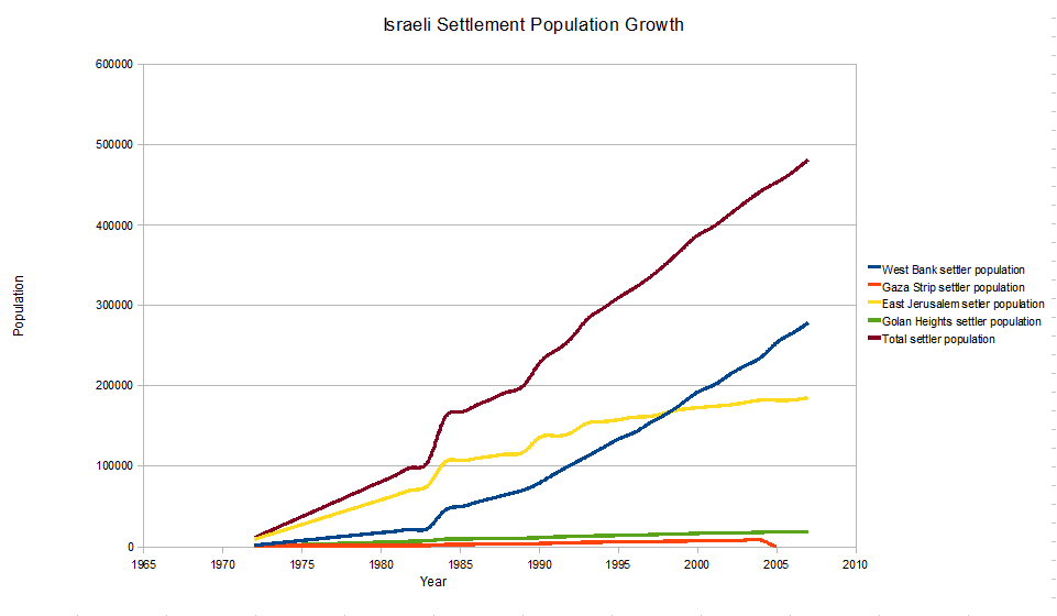
This is a timeline of the development of and controversy over Israeli settlements. As of January 30, 2022 the West Bank settlement population was 490,493 and the settler population in the Golan Heights was almost 27,000 and in East Jerusalem the settler population was around 220,000. 1967 * The cease-fire agreement following the 1967 Six-Day War leaves Israel in control of a number of areas captured during hostilities. * From Jordan, Israel gains control of the West Bank, including East Jerusalem. * From Egypt, Israel gains control of the Sinai Peninsula up to the Suez Canal, and the Gaza Strip. * From Syria, Israel gains control of most of the Golan Heights, which since 1981 has been administered under the Golan Heights Law. * The municipal borders of Jerusalem are extended to include all of the Old City as well as other areas. Residents within the new municipal borders are offered the choice between citizenship (subject to a few restrictions) and permanent residency ... [...More Info...] [...Related Items...] OR: [Wikipedia] [Google] [Baidu] |
Annexation
Annexation ( Latin ''ad'', to, and ''nexus'', joining), in international law, is the forcible acquisition of one state's territory by another state, usually following military occupation of the territory. It is generally held to be an illegal act.: "Annexation means the forcible acquisition of territory by one State at the expense of another State. It is one of the principal modes of acquiring territory... in contrast to acquisition a) of terra nullius by means of effective occupation accompanied by the intent to appropriate the territory; b) by cession as a result of a treaty concluded between the States concerned (Treaties), or an act of adjudication, both followed by the effective peaceful transfer of territory; c) by means of prescription defined as the legitimization of a doubtful title to territory by passage of time and presumed acquiescence of the former sovereign; d) by accretion constituting the physical process by which new land is formed close to, or becomes attached ... [...More Info...] [...Related Items...] OR: [Wikipedia] [Google] [Baidu] |
United Nations
The United Nations (UN) is an intergovernmental organization whose stated purposes are to maintain international peace and security, develop friendly relations among nations, achieve international cooperation, and be a centre for harmonizing the actions of nations. It is the world's largest and most familiar international organization. The UN is headquartered on international territory in New York City, and has other main offices in Geneva, Nairobi, Vienna, and The Hague (home to the International Court of Justice). The UN was established after World War II with the aim of preventing future world wars, succeeding the League of Nations, which was characterized as ineffective. On 25 April 1945, 50 governments met in San Francisco for a conference and started drafting the UN Charter, which was adopted on 25 June 1945 and took effect on 24 October 1945, when the UN began operations. Pursuant to the Charter, the organization's objectives include maintaining internationa ... [...More Info...] [...Related Items...] OR: [Wikipedia] [Google] [Baidu] |
United Nations Security Council Resolution 446
United Nations Security Council resolution 446, adopted on 22 March 1979, concerned the issue of Israeli settlements in the "Arab territories occupied by Israel since 1967, including Jerusalem".United Nations Security Council Resolution 446 22 March 1979 This refers to the of the , East Jerusalem and the |
Ariel (city)
Ariel ( he, אֲרִיאֵל; ar, اريئيل) is an urban Israeli settlement organized as a city council in the central West Bank, part of the Israeli-occupied territories, approximately east of the Green Line and west of the Jordan border. Ariel was first established in 1978 and its population was in , composed of veteran and young Israelis, English-speaking immigrants, and immigrants from the Former Soviet Union, with an additional influx of above 10,000 students from Ariel University.Ariel municipality Official website It is the fourth largest Jewish settlement in the West Bank, after Modi'in Illit, [...More Info...] [...Related Items...] OR: [Wikipedia] [Google] [Baidu] |
Yamit
Yamit ( he, ימית) was an Israeli settlement in the northern part of the Sinai Peninsula with a population of about 2,500 people. Yamit was established during Israel's occupation of the peninsula from the end of the 1967 Six-Day War until that part of the Sinai was handed over to Egypt in April 1982, as part of the terms of the 1979 Egypt–Israel peace treaty. Prior to the return of the land to Egypt, all the homes were evacuated and bulldozed. History Located in the Rafah Plain region south of the Gaza Strip, Yamit was envisioned as a large city for 200,000 people that would create a buffer zone between the Gaza Strip and the Sinai Peninsula. It was built on land in a 140,000 dunam (14,000 hectare) area from which some 1,500 Bedouin families of the Al-Ramilat tribes had been secretly expelled under the direct orders of the then-defense minister Moshe Dayan and Southern Command head Ariel Sharon. Construction of Yamit began in January 1975. When the first fifty residents ... [...More Info...] [...Related Items...] OR: [Wikipedia] [Google] [Baidu] |
Camp David Accords (1978)
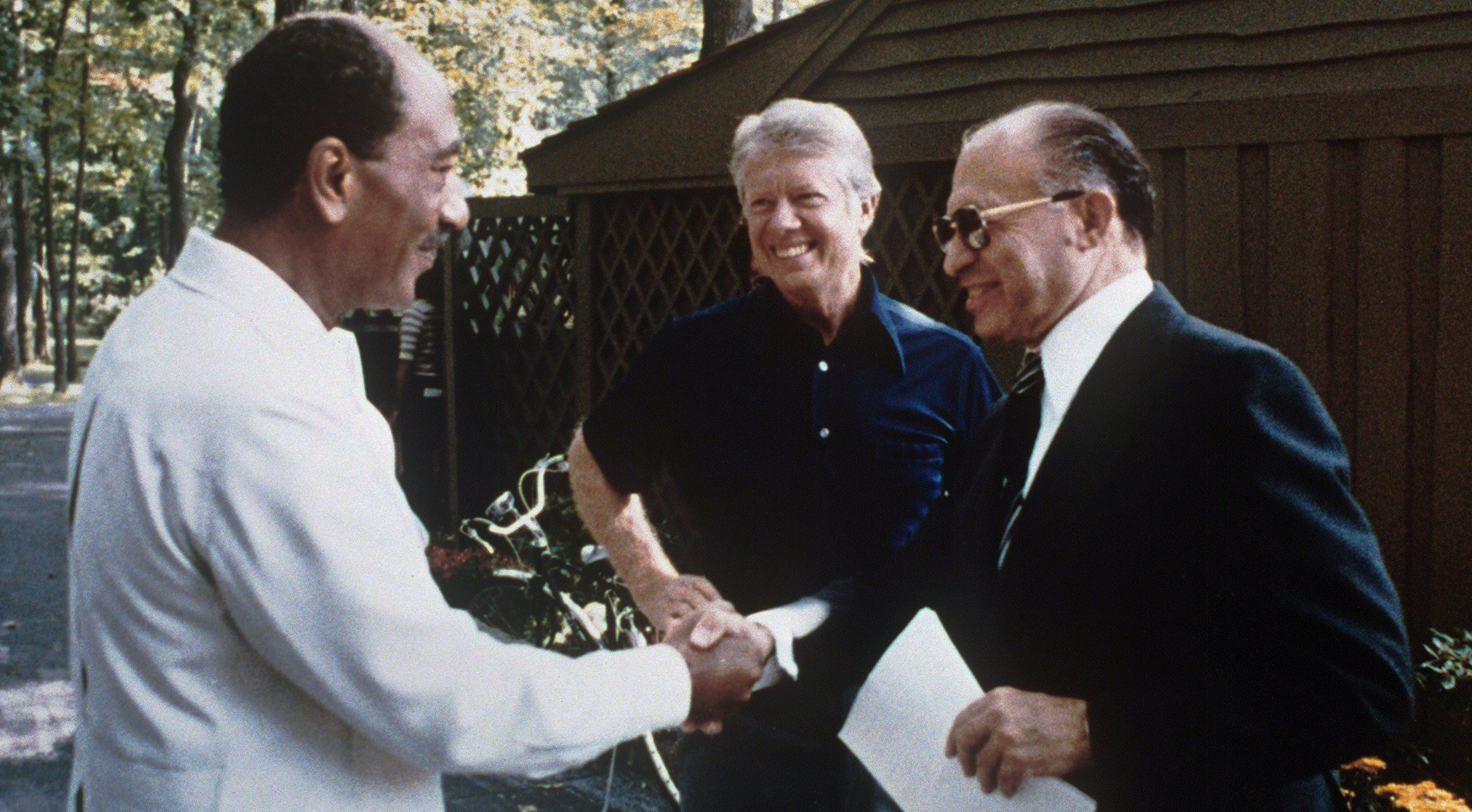
The Camp David Accords were a pair of political agreements signed by Egyptian President Anwar Sadat and Israeli Prime Minister Menachem Begin on 17 September 1978, following twelve days of secret negotiations at Camp David, the country retreat of the President of the United States in Maryland.Camp David Accords – Israeli Ministry of Foreign Affairs The two framework agreements were signed at the and were witnessed by President Jimmy Carter. The second of these framework ... [...More Info...] [...Related Items...] OR: [Wikipedia] [Google] [Baidu] |
Karnei Shomron
Karnei Shomron ( he, קַרְנֵי שׁוֹמְרוֹן, lit. "Rays (of light) of Samaria") is an Israeli settlement organized as a local council established in 1977 in the West Bank, east of Kfar Saba. Karnei Shomron is located northeast of Tel Aviv and north of Jerusalem. In it had a population of . The international community considers Israeli settlements in the West Bank illegal under international law, but the Israeli government disputes this. History According to ARIJ, Israel confiscated land from four nearby Palestinian villages of in order to construct Karnei Shomron: *713 dunams from Jinsafut, *512 dunams from Deir Istiya, * 229 dunams from Kafr Laqif, *216 dunams from Hajjah.Hajja village profile [...More Info...] [...Related Items...] OR: [Wikipedia] [Google] [Baidu] |
Beit El
Beit El or Beth El ( he, בֵּית אֵל) is an Israeli settlement and local council located in the Binyamin Region of the West Bank. The Orthodox Jewish town was settled in 1977-78 by the ultranationalist group Gush Emunim. It is located in the hills north of Jerusalem, east of the Palestinian city of al-Bireh, adjacent to Ramallah. In September 1997, Beit El was awarded local council status. The head of the local council is Shai Alon. In its population was . Its current population is 6,500 residents. The international community considers Israeli settlements in the West Bank illegal under international law, but the Israeli government disputes this. The Ulpana neighbourhood was evacuated when it emerged that it was built on private Palestinian land. The World Zionist Organization (WZO) halted land transactions in the Aleph neighbourhood of Beit El after it emerged that some 250 buildings there were constructed illegally, and fraud was suspected. Geography Beit El, with a ... [...More Info...] [...Related Items...] OR: [Wikipedia] [Google] [Baidu] |
Elkana
Elkana or Elqana ( he, אֶלְקָנָה) is an Israeli settlement and Local council (Israel), local council in the north-western Samarian hills in the West Bank, located 3.1 km to the east of the Green Line (Israel), Green Line and the city of Rosh HaAyin.Lands Authority first published tenders for the new homes West Bank settlement of Elkana in November of 2013 - Retrieved 5 September 2014 It was founded in 1977 by a group from Gush Emunim of religious and non-religious Jews, and by July 2020 it had a population of 3858. Israeli settlements in the West Bank are considered illegal under international law, but the Israeli government disputes this. [...More Info...] [...Related Items...] OR: [Wikipedia] [Google] [Baidu] |
Ma'ale Adummim
Ma'ale Adumim ( he, מַעֲלֵה אֲדֻמִּים; ar, معالي أدوميم) is an urban Israeli settlement organized as a city council in the West Bank, seven kilometers () east of Jerusalem. Ma'ale Adumim achieved city status in 1991. In 2015 its population was . It is located along Highway 1, which connects it to Jerusalem and the Tel Aviv Metropolitan Area. The international community considers Israeli settlements in the West Bank illegal under international law, but the Israeli government disputes this. Etymology The town name "Ma'ale Adumim" is taken from two mentions made of an area marking the boundaries between two Israelite tribes in the Book of Joshua. At , in a passage on the inheritance of the Tribe of Judah, it is stated that from the Stone of Bohan the border went up to Debir from the Valley of Achor, turning north to Gilgal, which faces the Ascent of Adummim south of the ravine. At , in a description of the inheritance by the casting of lots t ... [...More Info...] [...Related Items...] OR: [Wikipedia] [Google] [Baidu] |
Kiryat Arba
:''This article is mainly about the modern Israeli settlement, not the biblical town'' Kiryat Arba or Qiryat Arba ( he, קִרְיַת־אַרְבַּע, , Town of the Four) is an urban Israeli settlement on the outskirts of Hebron, in the southern West Bank. Founded in 1968, in it had a population of . The international community considers Israeli settlements illegal under international law, but the Israeli government disputes this. Biblical town: etymology and location In the Hebrew Bible Kiryat Arba is mentioned in the Hebrew Bible as the former name of Hebron and as the place where Abraham's wife, Sarah, has died: "And Sarah died at Kiriath-arba (that is, Hebron)" (). The Book of Joshua says: "Now the name of Hebron formerly was Kiriath-arba; this Arba was the greatest man among the Anakim." (). It is also a place listed as Nehemiah as where some of the people of Judah are living. There is no reference to Hebron in Nehemiah. Identification Some researchers identify Tel ... [...More Info...] [...Related Items...] OR: [Wikipedia] [Google] [Baidu] |


