|
Geology Of Iceland
The geology of Iceland is unique and of particular interest to geologists. Iceland lies on the divergent boundary between the Eurasian plate and the North American plate. It also lies above a hotspot, the Iceland plume. The plume is believed to have caused the formation of Iceland itself, the island first appearing over the ocean surface about 16 to 18 million years ago. The result is an island characterized by repeated volcanism and geothermal phenomena such as geysers. The eruption of Laki in 1783 caused much devastation and loss of life, leading to a famine that killed about 25% of the island's population and resulted in a drop in global temperatures, as sulfur dioxide was spewed into the Northern Hemisphere. This caused crop failures in Europe and may have caused droughts in India. The eruption has been estimated to have killed over six million people globally. Between 1963 and 1967, the new island of Surtsey was created off the southwest coast by a volcanic eruption. ... [...More Info...] [...Related Items...] OR: [Wikipedia] [Google] [Baidu] |
Iceland Mid-Atlantic Ridge Map
Iceland is a Nordic island country between the North Atlantic and Arctic Oceans, on the Mid-Atlantic Ridge between North America and Europe. It is culturally and politically linked with Europe and is the region's westernmost and most sparsely populated country. Its capital and largest city is Reykjavík, which is home to about 36% of the country's roughly 380,000 residents (excluding nearby towns/suburbs, which are separate municipalities). The official language of the country is Icelandic. Iceland is on a rift between tectonic plates, and its geologic activity includes geysers and frequent volcanic eruptions. The interior consists of a volcanic plateau with sand and lava fields, mountains and glaciers, and many glacial rivers flow to the sea through the lowlands. Iceland is warmed by the Gulf Stream and has a temperate climate, despite being a latitude just south of the Arctic Circle. Its latitude and marine influence keep summers chilly, and most of its islands have a pol ... [...More Info...] [...Related Items...] OR: [Wikipedia] [Google] [Baidu] |
Mid-Atlantic Ridge
The Mid-Atlantic Ridge is a mid-ocean ridge (a Divergent boundary, divergent or constructive Plate tectonics, plate boundary) located along the floor of the Atlantic Ocean, and part of the List of longest mountain chains on Earth, longest mountain range in the world. In the North Atlantic, the ridge separates the North American plate, North American from the Eurasian plate and the African plate, north and south of the Azores triple junction. In the South Atlantic, it separates the African plate, African and South American plate, South American plates. The ridge extends from a junction with the Gakkel Ridge (Mid-Arctic Ridge) northeast of Greenland southward to the Bouvet triple junction in the South Atlantic. Although the Mid-Atlantic Ridge is mostly an underwater feature, portions of it have enough elevation to extend above sea level, for example in Iceland. The ridge has an average spreading rate of about per year. Discovery A ridge under the northern Atlantic Ocean was first ... [...More Info...] [...Related Items...] OR: [Wikipedia] [Google] [Baidu] |
Tuya
A tuya is a flat-topped, steep-sided volcano formed when lava erupts through a thick glacier or ice sheet. They are rare worldwide, being confined to regions which were covered by glaciers and had active volcanism during the same period. As lava that erupts under a glacier cools very quickly and cannot travel far, it piles up into a steep-sided hill. If the eruption continues long enough, it either melts all the ice or emerges through the top of the ice and then creates normal-looking lava flows that make a flat cap on top of the hill. Discovering and dating the lava flows in a tuya has proven useful in reconstructing past glacial ice extents and thicknesses. Formation Tuyas are a type of subglacial volcano that consists of nearly horizontal beds of lava capping outward-dipping beds of fragmental volcanic rocks, and they often rise in isolation above a surrounding plateau. Tuyas are found in Iceland, British Columbia, the Santiam Pass region in Oregon, the Tuva, Tyva Republic i ... [...More Info...] [...Related Items...] OR: [Wikipedia] [Google] [Baidu] |
Interglacial
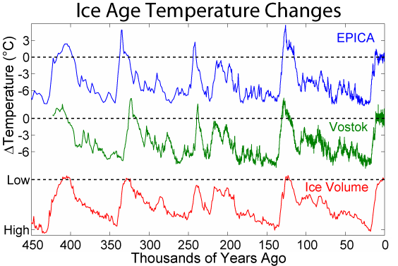
An interglacial period (or alternatively interglacial, interglaciation) is a geological interval of warmer global average temperature lasting thousands of years that separates consecutive glacial periods within an ice age. The current Holocene interglacial began at the end of the Pleistocene, about 11,700 years ago. Pleistocene During the 2.5 million years of the Pleistocene, numerous glacials, or significant advances of continental ice sheets, in North America and Europe, occurred at intervals of approximately 40,000 to 100,000 years. The long glacial periods were separated by more temperate and shorter interglacials. During interglacials, such as the present one, the climate warms and the tundra recedes polewards following the ice sheets. Forests return to areas that once supported tundra vegetation. Interglacials are identified on land or in shallow epicontinental seas by their paleontology. Floral and faunal remains of species pointing to temperate climate and indicating a ... [...More Info...] [...Related Items...] OR: [Wikipedia] [Google] [Baidu] |
Nunatak
A nunatak (from Inuit language, Inuit ) is the summit or ridge of a mountain that protrudes from an ice field or glacier that otherwise covers most of the mountain or ridge. They often form natural pyramidal peaks. Isolated nunataks are also called glacial islands, and smaller nunataks rounded by glacial action may be referred to as rognons. The word is of Greenlandic language, Greenlandic origin and has been used in English since the 1870s. Description The term ''nunatak'' is typically used in areas where a permanent ice sheet is present and the ridge protrudes above the sheet.J. J. Zeeberg, ''Climate and Glacial History of the Novaya Zemlya Archipelago, Russian Arctic''. pp. 82–84 Nunataks present readily identifiable landmark reference points in glaciers or ice caps and are often named. While some are isolated, they can also form dense clusters, such as Queen Louise Land in Greenland. Nunataks are generally angular and jagged, hampering the formation of glacial ice on thei ... [...More Info...] [...Related Items...] OR: [Wikipedia] [Google] [Baidu] |
Lithosphere
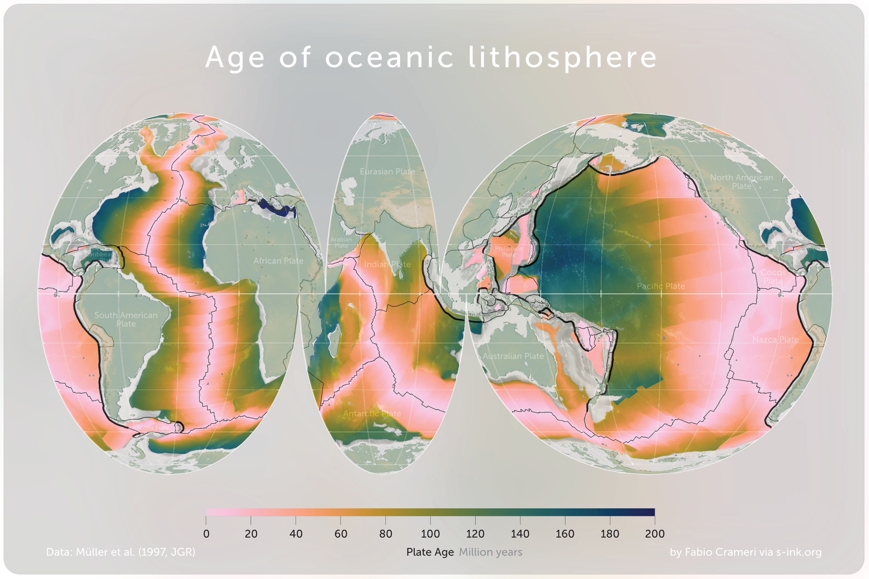
A lithosphere () is the rigid, outermost rocky shell of a terrestrial planet or natural satellite. On Earth, it is composed of the crust and the lithospheric mantle, the topmost portion of the upper mantle that behaves elastically on time scales of up to thousands of years or more. The crust and upper mantle are distinguished on the basis of chemistry and mineralogy. Earth's lithosphere Earth's lithosphere, which constitutes the hard and rigid outer vertical layer of the Earth, includes the crust and the lithospheric mantle (or mantle lithosphere), the uppermost part of the mantle that is not convecting. The layer below the lithosphere is called the asthenosphere, which is the weaker, hotter, and deeper part of the upper mantle that is able to convect. The lithosphere–asthenosphere boundary is defined by a difference in response to stress. The lithosphere remains rigid for very long periods of geologic time in which it deforms elastically and through brittle f ... [...More Info...] [...Related Items...] OR: [Wikipedia] [Google] [Baidu] |
Land Bridge
In biogeography, a land bridge is an isthmus or wider land connection between otherwise separate areas, over which animals and plants are able to cross and colonize new lands. A land bridge can be created by marine regression, in which sea levels fall, exposing shallow, previously submerged sections of continental shelf; or when new land is created by plate tectonics; or occasionally when the sea floor rises due to post-glacial rebound after an ice age. Prominent examples Former land bridges * The Bassian Plain, which linked Australia to Tasmania * The Antarctic Land Bridge, which connected South America, Antarctica, and Australia during the Late Cretaceous and Early Paleogene * The Bering Land Bridge (aka Beringia), which intermittently connected Alaska (Northern America) with Siberia (North Asia) as sea levels rose and fell under the effect of ice ages * GAARlandia, a hypothesized land bridge which potentially connected the Greater Antilles with South America d ... [...More Info...] [...Related Items...] OR: [Wikipedia] [Google] [Baidu] |
Mantle Plume
A mantle plume is a proposed mechanism of convection within the Earth's mantle, hypothesized to explain anomalous volcanism. Because the plume head partially melts on reaching shallow depths, a plume is often invoked as the cause of volcanic hotspots, such as Hawaii or Iceland, and large igneous provinces such as the Deccan and Siberian Traps. Some such volcanic regions lie far from tectonic plate boundaries, while others represent unusually large-volume volcanism near plate boundaries. Concepts Mantle plumes were first proposed by J. Tuzo Wilson in 1963 and further developed by W. Jason Morgan in 1971 and 1972. A mantle plume is posited to exist where super-heated material forms ( nucleates) at the core-mantle boundary and rises through the Earth's mantle. Rather than a continuous stream, plumes should be viewed as a series of hot bubbles of material. Reaching the brittle upper Earth's crust they form diapirs. These diapirs are "hotspots" in the crust. In particular, ... [...More Info...] [...Related Items...] OR: [Wikipedia] [Google] [Baidu] |
Crust (geology)
In geology, the crust is the outermost solid shell of a planet, dwarf planet, or natural satellite. It is usually distinguished from the underlying mantle by its chemical makeup; however, in the case of icy satellites, it may be defined based on its phase (solid crust vs. liquid mantle). The crusts of Earth, Mercury, Venus, Mars, Io, the Moon and other planetary bodies formed via igneous processes and were later modified by erosion, impact cratering, volcanism, and sedimentation. Most terrestrial planets have fairly uniform crusts. Earth, however, has two distinct types: continental crust and oceanic crust. These two types have different chemical compositions and physical properties and were formed by different geological processes. Types of crust Planetary geologists divide crust into three categories based on how and when it formed. Primary crust / primordial crust This is a planet's "original" crust. It forms from solidification of a magma ocean. Toward the end o ... [...More Info...] [...Related Items...] OR: [Wikipedia] [Google] [Baidu] |
Rift
In geology, a rift is a linear zone where the lithosphere is being pulled apart and is an example of extensional tectonics. Typical rift features are a central linear downfaulted depression, called a graben, or more commonly a half-graben with normal faulting and rift-flank uplifts mainly on one side. Where rifts remain above sea level they form a rift valley, which may be filled by water forming a rift lake. The axis of the rift area may contain volcanic rocks, and active volcanism is a part of many, but not all, active rift systems. Major rifts occur along the central axis of most mid-ocean ridges, where new oceanic crust and lithosphere is created along a divergent boundary between two tectonic plates. ''Failed rifts'' are the result of continental rifting that failed to continue to the point of break-up. Typically the transition from rifting to spreading develops at a triple junction where three converging rifts meet over a hotspot. Two of these evolve to t ... [...More Info...] [...Related Items...] OR: [Wikipedia] [Google] [Baidu] |
Greenland
Greenland is an autonomous territory in the Danish Realm, Kingdom of Denmark. It is by far the largest geographically of three constituent parts of the kingdom; the other two are metropolitan Denmark and the Faroe Islands. Citizens of Greenland are full Danish nationality law, citizens of Denmark and European Union citizenship, of the European Union. Greenland is one of the Special territories of members of the European Economic Area#Overseas countries and territories, Overseas Countries and Territories of the European Union and is part of the Council of Europe. It is the List of islands by area, world's largest island, and lies between the Arctic Ocean, Arctic and Atlantic oceans, east of the Arctic Archipelago, Canadian Arctic Archipelago. It is the location of the northernmost point of land in the world; Kaffeklubben Island off the northern coast is the world's Northernmost point of land, northernmost undisputed point of land—Cape Morris Jesup on the mainland was thought to ... [...More Info...] [...Related Items...] OR: [Wikipedia] [Google] [Baidu] |
Seafloor Spreading
Seafloor spreading, or seafloor spread, is a process that occurs at mid-ocean ridges, where new oceanic crust is formed through volcanic activity and then gradually moves away from the ridge. History of study Earlier theories by Alfred Wegener and Alexander du Toit of continental drift postulated that continents in motion "plowed" through the fixed and immovable seafloor. The idea that the seafloor itself moves and also carries the continents with it as it spreads from a central rift axis was proposed by Harold Hammond Hess from Princeton University and Robert Dietz of the U.S. Naval Electronics Laboratory in San Diego in the 1960s. The phenomenon is known today as plate tectonics. In locations where two plates move apart, at mid-ocean ridges, new seafloor is continually formed during seafloor spreading. Significance Seafloor spreading helps explain continental drift in the theory of plate tectonics. When oceanic plates diverge, tensional stress causes fractures to occur i ... [...More Info...] [...Related Items...] OR: [Wikipedia] [Google] [Baidu] |


